
What Are The Things To Do In Pasikudah? Know The Place Where The Indian Ocean Forgets How to Be Rough

With Pasikudah getting its first floating dining platform thanks to Sun Siyam, this coastal town around 35 km away from Batticaloa is going to offer a more luxurious experience. 

While this is a delightful upgrade, the first thing I noticed in Pasikudah was the silence. 

With the sands and turquoise waters that almost looked surreal, it was away from the crowds. 

Also, the absence of crashing surf and urgent pull made exploring the shoreline easier for me. There was no need for reminders to stay close to the shore. 

Furthermore, in the south, at Unawatuna Beach and Mirissa Beach, the Indian Ocean threw itself at land with real intent. 

At Pasikudah on the eastern coast, it was just a gentle lapping, the kind of sound that makes you lower your voice without realizing it.

The shore here waits for the Ocean to arrive!

How To Reach Pasikudah?

Pasikudah is at a distance of around 300 kilometers from Colombo. 

So, if you are traveling from Colombo or straight from the Bandaranaike International Airport, it will be a road journey of five to six hours. 

A little taxing it may sound, but it can be a wonderful opportunity for cultural exploration. The road takes you through the Cultural Triangle of Anuradhapura, Polonnaruwa, and Kandy.

The key destinations on this circuit also include the Sigiriya Rock Fortress and the Dambulla Royal Cave

However, during my trip to Sri Lanka, I took the 6075 Batticaloa Special train from Colombo Fort to the Valaichchenai Railway Station. 

This is the closest to Pasikudah, and you can reach the coastal town in 15-20 minutes in a tuk-tuk. 

The train started at 3:15 PM and reached Valaichchenai Railway Station at 10:50 PM. I was traveling in a third-class compartment, and the ticket price was LKR 1400. 

There are two other train options from Colombo Fort to Pasikudah. The first one leaves at 6 AM and reaches Valachchenei at 2:40 PM.

Also, the last train for the day departs the Colombo Fort Station at 7 PM and reaches Valachchenei at 3:23 AM.

Pasikudah: A Place With A Multilayered History

Pasikudah shows Tamil influence in its naming, and it is roughly translated to “Green Algae Bay.”

The name is, of course, not flattering for a place that looks this beautiful. However, it ties the link perfectly to the past when Pasikudah was a working fishing settlement.

It became a resort town much later. 

Furthermore, Pasikudah is the place where the Dutch first landed in Sri Lanka in 1602. I could see the traces of that Colonial period scattered everywhere. 

There were old buildings, a slender lighthouse, and a fort dating to 1628 with sweeping views over the coastline, about 20 minutes away near Kalkudah.

2004 And 2009: Two Landmark Years For The History Of Pasikudah And Sri Lanka 

The history of Pasikudah got erased twice in recent years. 

The Tsunami in 2004 hit this stretch of coast hard. 

Also, decades of Civil War kept Pasikudah off the tourist map entirely until the war ended in 2009, like Kilinochchi and Mullaitivu

Standing on the beach, I watched families wade out into water that barely reached their knees even 400 meters from shore.

It was hard to picture how quiet and forgotten this coastline was less than two decades ago. 

The recovery of this resort town has been consistent and in places quite luxurious. 

However, the bones of an old fishing village are still there.

What Are The Things To Do In Pasikudah? 

Pasikudah is not a beach that you visit for drama or some out-of-the-box adventure. 

You can chase that in the moody coastline I found in Mannar or the raw remoteness of Vavuniya

Here the water is the whole point, and the things to do in Pasikudah revolve around that. 

1. Exploring The Shallow Reef Coastline 

Exploring The Shallow Reef Coastline 

Pasikudah has one of the longest stretches of shallow reef coastline in the world. 

I walked out nearly 500 meters from the shore one morning, and the water still sat at my waist.

It was dreamy, and it felt like the ocean had turned into a very warm and large swimming pool. 

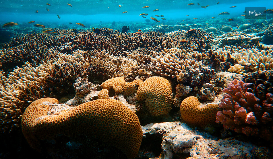
Also, the shallow gradient makes it an ideal snorkeling spot. 

I spent an afternoon drifting over coral patches just offshore. I watched for the reef fish that dart in and out of the structures close to the resort strip. 

Diving operators here also run trips further out for anyone wanting more depth than the bay itself provides.

Moreover, if you are traveling with kids, it is one of the safest beaches in Sri Lanka. So, you will usually notice families visiting this beach and not the usual surf crowd. 

2. Experiencing The Rawness Of Kalkudah

The tuk-tuk ride to Kalkudah in the north was a brilliant decision as it impressed me with its quieter and rawer feel. 

Kalkudah had fewer sun loungers and resorts and more fishermen. 

I spent half a day in a coastline that was not fully smoothed out yet.

3. Exploring Beyond The Beach

I wanted to get inland for at least one day. 

So, I took a drive south and reached Batticaloa town. Batticaloa had its own Dutch fort and a slower, more local rhythm than the resort strip.

I loved wandering its lagoon-side streets in the afternoon and talked to fishermen whose families had been working in the same waters for generations.  

Then I explored the lagoon system of Batticaloa by bicycle and saw rice paddies, water buffalo, and small fishing communities up close. 

I rented the bicycle from a local operator, and they charged me 300 LKR per hour. 

4. A Visit To The Somawathiya National Park

A Visit To The Somawathiya National Park

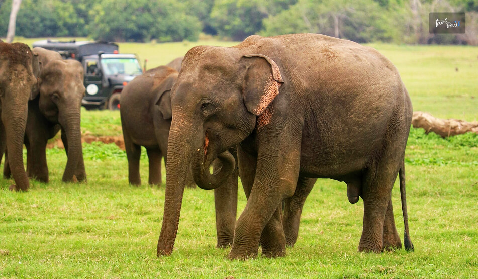
The Somawathiya National Park is at a distance of around 68 km from Pasikudah. It is a protected site known for its biodiversity. 

It has leopards, elephants, water buffalo and various species of birds, 

Also, it is a prominent pilgrimage site with the stupa housing the relic (the right canine tooth) of Lord Buddha. 

The experience at Somawathiya National Park was very different from the time at the beach, and the Somawathiya Chaitya reminded me of the Great Stupa at Sanchi in Madhya Pradesh, India. 

Overall, Pasikudah rewarded me as a place to slow down. However, with enough history and the spiritual vibe of the Stupa, my time here was more rewarding.

Share on Social Media

Sibashree is a travel, culture, and leisure writer who has been writing since the age of 12 and professionally since 2014. With more than a decade of travel writing experience and journeys across India and several parts of the world, she brings a deeply personal and thoughtful perspective to her work. A student of English Literature and Mass Communication, Sibashree has always viewed travel as more than movement — for her, it has been a way of understanding people, cultures, and herself. Her passion for spiritual exploration has also led her to many unusual and meaningful destinations over the years. Outside of writing, Sibashree enjoys watching European cinema, reading about global politics, and reflecting on the stories hidden within everyday places.

Leave a Reply

Your email address will not be published. Required fields are marked *

title-img Related

READ MORE world's end sri lanka

World’s End, Sri Lanka: Chasing the View Before the Clouds Roll In

BY  Sibashree Aug 31, 2026

Nobody tells you how early a '5 AM start' actually feels until you are standing in the dark outside your Nuwara Eliya guesthouse, breakfast pack in hand, waiting for a tuk-tuk.   But that is the deal with World's End.  The view is clear from about 9 AM to 10 AM.  After that, clouds roll in off the valley and swallow the whole thing whole.   I had heard this enough times before arriving that I did not question the alarm. And I am glad I did not.  By the time I reached the escarpment, the drop in front of me was still clear enough to see the coast, some 80 kilometres away.  World's End is a sheer escarpment inside Horton Plains National Park, in Sri Lanka's central highlands.   You have to take a circular hiking trail to reach it, and the same route also takes you to Baker's Falls and a smaller companion viewpoint called Mini World's End.  It has become one of the most-hiked routes in the country precisely because the effort-to-reward ratio is so favourable.  It is a manageable walk for a view most people only expect to earn after a serious trek.  World’s End, Sri Lanka: At A Glance  Location Horton Plains National Park, central highlands  Elevation at start About 2,100 metres  Drop at World's End Approximately 870–880 metres  Circular trail distance 9–9.5 km (Red Bridge → Mini World's End → World's End → Baker's Falls → back)  Typical hike duration 2.5–4 Hours  Park hours 6 AM to 6 PM  Best time to visit January to March (Driest Months). You must arrive by 6 AM regardless of season.  Nearest base Nuwara Eliya   Why The Early Start Actually Matters This is not exaggerated marketing. World's End genuinely clouds over by mid-morning most days, often as early as 9 AM.  The park opens at 6 AM, and the guidance from pretty much every guide, driver, and fellow hiker I spoke to was the same.  Get there at opening, start walking immediately, and don't dawdle at Mini World's End if clear skies at the main viewpoint are your priority.   I reached World's End a little under an hour and a half after setting off and had maybe twenty clear minutes before the first wisps of cloud started drifting up from the valley below.  There is no public transport directly to Horton Plains from Nuwara Eliya.  So you are looking at a hired tuk-tuk, car, or a pre-booked tour.  The PickMe app works if you would rather arrange it yourself the night before.   Whatever you choose, the pre-dawn logistics are worth planning a day ahead, since most hotels won't have breakfast ready at 4:30 AM and will instead hand you a packed breakfast to eat on the trail.  The Hike Itself The full loop runs roughly 9 to 9.5 kilometres and is considered moderate rather than difficult.  It is mostly flat with some gentle inclines.   It is well-marked, and it is notably the only national park in Sri Lanka where you are allowed to walk the trail without a mandatory guide.   From the Red Bridge entrance, it is about 2 kilometres to Mini World's End.  Then on to the main viewpoint, before the trail loops back via Baker's Falls, one of the widest waterfalls in the country, and a good spot to slow down once the pressure of beating the clouds is behind you.  Along the way, expect sambar deer grazing close to the trail.  They are genuinely unbothered by hikers here.  I also spotted purple-faced langurs, giant squirrels, and a decent range of highland birdlife.   Leopards are present in the wider Horton Plains area, but sightings are rare enough that I would not build any expectations around it.  Mini World's End Vs. The Main Event  It is easy to treat Mini World's End as a warm-up and rush past it.  However, it is worth a few minutes on its own terms.  A smaller drop, fewer people at that hour, and in some ways a calmer view than the more crowded main viewpoint!  Some hikers reverse the usual direction of the loop specifically to hit World's End last rather than first.  Either way works, but going clockwise from Red Bridge (Mini World's End, then World's End, then Baker's Falls) is the standard and the one most guides default to.  Planning Your Visit World's End earns its reputation honestly.  It is one of the few views in Sri Lanka that lives up to the hype, provided you respect the clock.   The hike itself is forgiving enough for most fitness levels.  Also, the wildlife along the way is a pleasant bonus, and the payoff at the escarpment, on a clear morning, is the kind of view that makes the 5 AM alarm feel like a fair trade.  Entry Fees  Expect to pay in the region of USD 20–25 per foreign adult visitor. Also, you will have to pay a separate vehicle fee if you are driving or being driven in.  The total for a couple with a hired tuk-tuk can run well over what the headline entry fee alone suggests. Fees are collected in USD or LKR at the park entrance.  What To Pack  Pack layers as it is cold enough at 2,100 metres before dawn to want a proper jacket. However, you will likely be down to a T-shirt by mid-hike.   Add sturdy shoes, water, the breakfast pack, and a hat for once the sun burns through.   The terrain does not demand technical gear, but the temperature swing from predawn to midday catches people out.  Best Time Of Year  January to March is generally the driest and most reliable stretch for clear views.  However, the daily mist pattern matters more than the season.  Even in the driest months, arriving after 9 AM risks losing the view entirely. An early start in a wetter month can still pay off.  Where This Fits In A Sri Lanka Itinerary  World's End is a natural pairing with a Nuwara Eliya stay. It is often combined with tea estate visits, Adam's Peak, or the train journey onward to Ella.   Given the early start and 3–4-hour round trip, I would treat it as a dedicated half-day rather than trying to combine it with much else that same morning.  By the time you are back at the entrance, most of the day's clear-view window has already closed anyway.

READ MORE Anuradhapura

What Are The Best Places To See In The Sacred City Of Anuradhapura, Sri Lanka? 

BY  Sibashree Apr 21, 2026

Anuradhapura is a part of the Golden Triangle of Sri Lanka along with the Dambulla Royal Cave Enclave, Polonnaruwa, and Sigiriya Rock Fortress.  Furthermore, the Sacred City of Anuradhapura, a UNESCO World Heritage Site, was built from the “cutting of a Bodhi Tree” or the “Tree of Enlightenment.”  Before 993, when it was abandoned due to an invasion, it was the political and religious capital of Ceylon, the previous name for Sri Lanka.  Also, if Jaffna attracted me with its Tamil Culture and Hindu Temples, Anuradhapura was a great calling because it was the first place to adopt Buddhism outside India, the country I belong to.  Moreover, Jetavanaramaya, the early 4th-century BCE Stupa, was once the “third-largest man-made building in the world,” with an original height of 122 meters.  However, while the Jetavanaramaya Stupa continues to evoke awe with its grandeur and mystery, the other ruins and remains of Anuradhapura also wait to tell you the history and cultural richness of the region.  So, here is a brief discussion on the places I visited in Anuradhapura.  What Are The Places To Visit In Anuradhapura?  I was staying in a guest house near the Sacred City of Anuradhapura. I rented a bicycle from my guest house for LKR 500, and I took the back route as the staff in the guesthouse guided me.  Off the main road, the cycling experience was beautiful, and I loved spotting the roaming peacocks and little children waving at me.  Beyond the charming views and ambiance, I noticed one more thing. In Anuradhapura, the past and the present walk side by side.  There have been no evictions of the locals in the name of preserving or promoting the ancient ruins and remains in a UNESCO World Heritage Site.  Nevertheless, after talking to the local children for a while, I reached the entrance of the Anuradhapura Sacred City. The entry fee was around 9500 LKR or INR 2800.  However, remember that the ticket includes archaeological sites such as Jetavanaramaya, Abhayagiriya, Ruwanwelisaya, and Thuparamaya. So, if you want to explore other sites such as the Isurumuniya Viharaya, you will need to pay separate fees.  Nevertheless, these are the places I visited in Anuradhapura.  “This sacred city was established around a cutting from the 'tree of enlightenment', the Buddha's fig tree, brought there in the 3rd century B.C. by Sanghamitta, the founder of an order of Buddhist nuns.  Anuradhapura, a Ceylonese political and religious capital that flourished for 1,300 years, was abandoned after an invasion in 993.  Hidden away in dense jungle for many years, the splendid site, with its palaces, monasteries, and monuments, is now accessible once again.” - UNESCO World Heritage Convention.  1. Abhayagiri Vihara Stupa Complex The Abhayagiri Vihara Gargantuan Stupa is magnificent, and the brick stupa creates a contrast against the bright blue sky and the lush greenery of Anuradhapura.  King Vattagamani Abhaya or Valagamba founded this Stupa in the first century BCE. This prominent center of Mahayana Buddhism remains an active place of worship.  Also known as the Northern Monastery or Uttara Vihara, it changed the course of Buddhism in Sri Lanka by deviating from the monolithic tradition of Theravada Buddhism.  Moreover, the Abhayagiri Vihara Stupa is the first Stupa in Sri Lanka to house the tooth relic of Buddha.  Also, the Abhayagiri Dagoba or Stupa at the epicenter of the Abhayagiri Vihara Complex is one of the largest stupas in Sri Lanka.  The Structure And Architecture Of The Abhayagiri Vihara Apart from the Stupa or Dagoba, most parts of the Abhayagiri Vihara are in ruins. There were living houses for the monks and students, libraries, dinner halls, and meeting halls surrounding the Stupa.  Here is a detailed overview of the structures as I saw them. However, the heat will be scorching, and you will find langur monkeys roaming around.  So, try to be there by 6 AM, when the gates open, or after 4 PM. The Sacred City remains open till 8 PM. However, it will take you around an entire day if you want to explore the major ruins of the Anuradhapura Sacred City. The Dagoba Or The Stupa  The Stupa or Dagoba in the Abhayagiri Vihara is in a well-preserved condition. The massive bell-shaped structure of the stupa has a height of around 120 meters, and at its widest, the circumference is close to 350 meters.  The dome, made of brick and lime mortar, has four entrances, and you will find a Devatakotuva or a cylindrical spire and Hataraskotuva or a square-shaped structure as the crowns of the Stupa.  Image Houses, Refectories, And Sub Shrines  I saw the remains of various refectories, image houses, living complexes, and sub-shrines around the stupa.  Among the smaller stupas, the Indikatu Seya and Silasobbhakandaka Cetiya are the most common.  Meeting Halls The remains of the meeting halls or Uposathagharas have been found in the complex.  These Uposathagharas were multi-storied, and Ratnaprasadaya or the jewel mansion was most prominent among them.  Congregation Hall The Sannipatasala, or the congregation hall near the southern entrance of the stupa, is the largest hall in the complex.  The image of Nagaraja, or the king of snakes, or Virupaksha, the protector of the Western Direction, was found in this congregation hall, which is now in ruins.  You can see this image at the Abhayagiri Museum.  Abhisheka Mandapa Or Anointing Pavilion The Abhisheka Mandapa had a stepped entrance, and people believe it to be the place where the statues of Lord Buddha and other Bodhisattvas were consecrated.  Some even consider this the bathing house or Snanghara.  Stone Slabs  Many stone slabs with inscriptions in Nagari Script have been found in this site.  Again, there are two moon stones in Anuradhapura, and one was found at the Queen’s Pavilion and the other at Mahasena’s Palace.  These moon stones are significant features of Buddhist stupas or shrines, as these semi-circular stone structures depict the Buddhist Samasara.  The Dining Room The dining room or hall of the Abhayagiri Vihara has a stone-clad trough, and it is ideal for storing or serving rice that could feed 5000 monks.  Furthermore, there was a dining area, hearths, underground channels, grinding stones, and a sundial in the site Faxian or Fa-Hien described as the dining hall.  The dining hall also has two courtyards.  The Bodhi Tree Shrine The Bodhi Tree Shrine, or the Bodhighara is a subsidiary shrine of the Abhayagiri Stupa. As a token of Buddha’s enlightenment, Sanghamitta, a Buddhist nun from India, brought saplings of the Bodhi Tree.  She planted the saplings in Abhayagiri, and many patrons built small aediculae-like shrines around these trees.  These sub-shrines had images of Lord Buddha in a meditative or Samadhi posture and his footprints.  Moreover, excavation of Buddha statues took place in the Bodhighara sites, and one of them is from the 3rd century BCE, and these resemble the sculptures of the great Gupta dynasty in India.  You can visit the Anuradhapura Archaeological Museum if you want to see these Buddha statues. The Ponds  The tanks and reservoirs near the living quarters were the main sources of water for the complex.  However, water in these reservoirs or tanks came from the Kuttam Pokana or Twin Ponds to the far east of the Stupa.  Moreover, these rectangular ponds were built by Aggabodhi I in the 6th or 7th century CE, and they have shallow ridges, and the inner walls are made of polished stone.  However, for me, the most fascinating thing was the stone slab with the motif of a hooded cobra.  Also, this hooded cobra or Naga establishes a deep connection with India, as Nagas and water have deep connections in Indian mythology.  As I walked further, I came across the Elephant Pond or Eth Pokuna. It is the largest artificial tank in Sri Lanka, and it is the main water supply for all the tanks and reservoirs in the Vihara Complex.  Here also, I noticed a depiction of a hooded cobra on a stone slab.  At the end of exploring the Abhayagiri Vihara Stupa Complex, I must tell you that you must read a little about the place before a visit.  Otherwise, it will be difficult for you to catch up when the guide shares the details.  2. Jethawanaramaya Stupa You will also find the Jetavanaramaya Stupa in the Sacred City of Anuradhapura. It was one of the largest man-made structures in the world, and it ranked only after the Great Pyramids of Giza.  The original height of this structure was 122 meters, and after restoration, the height is now 71 meters.  The stupa, built by King Mahasena in the 3rd Century AD, is a part of a large Jetavana Vihara complex that used to house around 200 monks. Also, like the Abhayagiri Vihara, it has a brick architecture.  This once again indicates how ancient Anuradhapura was a hub of brick production. In fact, Ruwanwelisaya, the most sacred stupa of the country inside the Anuradhapura Sacred City Complex, also had a brick architecture.  However, for the recent restoration, they used cement in the outer layer of the stupa.  Moreover, massive excavation works have taken place in the Sacred City of Anuradhapura, and the gold panels showing the imagery of the Bodhisattva and the partial inscriptions of the Prajñāpāramitā Sutra.  Now, Prajñāpāramitā Sutra is the foundational text of Mahayana Buddhism. This shows how the Jethawanaramaya Stupa was the hub of different Buddhist thoughts and schools. However, you can see these gold panels now at the Colombo Museum.  Also, I came to know about another fascinating thing from a monk here, that the stupa used to have a diamond in the crown. It used to turn aside lightning during the monsoon season.  3. The Gleaming White Ruwanwelisaya Stupa  The Ruwanwelisaya Stupa is most famous among the locals and followers of Buddhism.  Now, unlike the Ritigala Forest Monastery, the Ruwanwelisaya Stupa or the other stupas in the complex are live hubs of Buddhist practices.  Also, the Ruwanwelisaya Stupa is especially famous for housing the remains of Lord Buddha.  Originally, the Ruwanwelisaya Stupa was much smaller than the Jethawanaramaya Stupa. However, thanks to continuous maintenance, it now stands at a height of 100 meters.  Now, this was my experience in the ancient ruins of Anuradhapura. If you want to explore more, you can visit the Kaudulla National Park, at a distance of less than 2 hours, and the Hurulu Eco Park, at a distance of 1 hour and 50 minutes.   Location And How To Reach Anuradhapura?  Anuradhapura City is located on the banks of the Malwathu Oya. It is the capital of the central-west region of Sri Lanka and the district of Anuradhapura.  Anuradhapura is a 4-hour journey from Colombo and Kandy.  Once I explored the top attractions in Kandy, I took a minivan, which cost me LKR 1600. Now, you will also get private and public buses.  However, I had luggage and wanted to keep the schedule flexible. So, I chose the minivan.  Things To Remember For A Trip To Anuradhapura The Sun is merciless in Anuradhapura, even if you visit the Sacred City in winter. It becomes unbearable past 11 AM.  So, you have to really start early.  Also, carry water and wear full-sleeve clothes to maintain the dignity of the place and protect your skin from the Sun.  Moreover, as I have mentioned, visiting a place like Anuradhapura demands preparation. So, study well and have basic ideas about these stupas beforehand. 

READ MORE Diyaluma Waterfall

Diyaluma Waterfall, Sri Lanka: The Eternal Memoir Of Love (Location, Hiking, And More)

BY  Sibashree Mar 16, 2026

After visiting the Nine Arch Bridge and the iconic blue trains, my next stop was the Diyaluma Waterfall, at a distance of around 45 km.  Now, Sri Lanka is full of hidden gems. Along with the Ritigala Forest Monastery, this waterfall has also offered me a slice of offbeat Sri Lanka.  Furthermore, the Diyaluma Waterfall, with a height of 220 meters, is the second-tallest waterfall in Sri Lanka, and it has many natural infinity pools.  If those were not reasons enough, Diyaluma Waterfall is irresistible for the local tragic love story associated with it. Also, it is a place of great ecological importance.  Moreover, the journey from Ella to Poonagala and the trek further offer an equally unforgettable experience.  Here are more details about visiting the Diyaluma Waterfall, its location, transport options, history, hiking experience, and more.  Where Is Diyaluma Waterfall?  The Diyaluma Waterfall is on the Colombo-Badulla highway in the Badulla district of Sri Lanka.  Koslanda, around 6 km west, is the closest town to the Diyaluma Waterfall.  Furthermore, it is located at a distance of around 30 km from Ella. Also, the waterfall is located about 196 km away from Kandy, the cultural hub of central Sri Lanka.  Moreover, the Kirindi Oya River has formed this waterfall. This river starts flowing near Bandarawela and flows across the central part of Sri Lanka.  How To Reach The Diyaluma Falls, Sri Lanka?  Tuk-tuks are easily available from Ella to Poonagala. Further, from the Poonagala village at the top, you have to do a short hike to reach the Diyaluma Falls.  However, you can also hike from Koslanda. This is a bottom-to-top hike and way more difficult than the top-to-bottom hike from Poonagala.  Also, the tuk-tuk to the Poonagala village cost me LKR 4000.  Moreover, remember that you have to inform your tuk-tuk driver that you need to go to the upper Diyaluma Falls and trek down from there. 1. Hiking From Poongala To Diyaluma Falls  Carry an offline map when hiking from Poongala to the Diyaluma Falls as the network is inconsistent here.  Furthermore, you must take your tuk-tuk driver as a guide or a different local guide for the hike.  My trek to the falls started from the Makaldenya Junction, and I walked for around 30 minutes to reach the Upper Diyaluma Waterfall.  The path is even, and that is why you need to wear proper hiking shoes with a good grip. Also, long and dry grasses cover the entire route.  You will find all the infinity pools here, and taking a bath is a must, considering the heat and strain of walking downhill.  Then, I took a walk of around 10 minutes to reach the Lower Diyaluma Fall. From there, you can see water falling into the valley from a height of 220 meters.  Also, this is the moment you realize the meaning of the Diyaluma Waterfalls. The name is a combination of Diya and Haluma.  Moreover, the name means the “liquid light” or a “rapid flow of water.”  2. Hiking From Koslanda To Diyaluma Falls  The hike from Koslanda is difficult. However, it offers an amazing view of the waterfall from the Diyaluma Falls Bridge below.  Furthermore, the hike takes around 20 to 30 minutes, and on this hiking route, you will find many snacks and coconut shops.  What Are The Things To Do At Diyaluma Falls?  To enjoy hiking and other activities at the Diyaluma Falls, you have to arrive a little early. The waterfalls are open from 6 AM to 5 PM.  Then, you can enjoy a bath in the infinity pools, relax on the rocks, or talk to the locals. In fact, I got to know about the history of this waterfall when talking to a local hiker.  1. Swimming In The Natural Infinity Pools Of The Diyaluma Waterfall On the edge of the main Diyaluma Waterfall, you will find the main natural infinity pool. Also, you will find many other natural infinity pools formed by the Upper Diyaluma Waterfall.  However, you must check with the locals and take enough precautions before getting into the water.  2. Relaxing On The Surrounding Rocks It may not sound very appealing to you. However, for me, who always cherishes TheLowDownUnder Travel experiences, it is a great thing to experience.  Sitting on a rock and seeing streaks of water gushing from a height of 220 meters. You don’t get to see these scenes often, right? Also, don’t forget to bring a towel if you want to sit on the rocks and relax.  3. Talking To The Locals  I come from a country where cricket is the religion. Sri Lanka also has a celebrated cricket team and has produced legends such as Sanath Jayasuriya, Kumar Sangakkara, Muttiah Muralitharan, and Arjuna Ranatunga.  So, it was great fun talking about cricket.  Then, a local guy shared the history of the Diyaluma Waterfall and the tragic love story associated with it. The History Of The Diyaluma Waterfall  A king once fell in love with a lady. However, she was from a lower caste, and the societal norms did not allow them to get married. So, they fled. Unfortunately, people against it chased them down, and the lady fell into the waterfall and died.  Safety Norms To Follow While Visiting The Diyaluma Falls  No set rule exists for the visitors to the Diyaluma Falls, and that is probably the most concerning matter.  The tourist inflow here is high, and most of them are adrenaline junkie.  So, stand on the edge and swim in the infinity pools, but with caution. Moreover, avoid visiting the waterfall in the monsoon season, from September to early December.  Even if you hike in these months, do not swim in the waterfall.  Overall, the Diyaluma Waterfall remains the symbol of the grandeur of nature, and the myths associated with it make it more intriguing.  So, if you are in Sri Lanka, don’t miss a hike to this waterfall, which is also at the epicenter of a unique ecosystem.  Moreover, enjoy the serenity and spirituality in the air.