Explore
The Unexplored

Luang Prabang, Kotor Montenegro, Great Barrier Island Raja Ampat, Jaffna, Tucumán, Suva Fiji, Nuuk Greenland São Tomé, and Chios Greece.

title img

Paradise On Earth

Find The Perfect Escape.
Kiri Vehera

Kiri Vehera, Polonnaruwa: Walking Around Sri Lanka’s Best-Preserved Milk Stupa

BY  Sibashree Sep 29, 2026

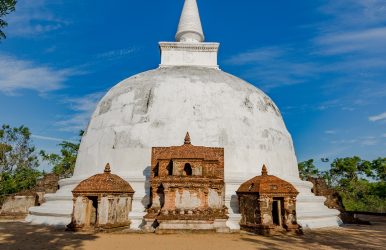
I got a glimpse of the Kiri Vehera through a gap in the trees.  It was milky white, and even early in the morning, it looked the brightest among the surrounding ruins.  Also, it is fascinating that the stupa is one of the few in Sri Lanka to have its original structure even after around 900 years.  Locals say that when the stupa was discovered amidst the jungle, its chunam, or lime coating,g was still intact.  Thus, it got its name as Kiri Vehera, or Milk White Stupa.  Furthermore, along with being the best-preserved stupa, it is also a classic example of Bubulakara, or the bubble-shaped form of stupa.  Kiri Vehera At A Glance DetailFactMeaning“Milk Stupa”It was originally called Rupavati Chetiya.BuilderQueen Subhadda, consort of Parakramabahu I (1153–1186)She was also known as Bhaddavati.TypeBubbulakara (bubble-shaped) stupa on three receding terracesHeightAround 24 meters for the damaged stupa. Base diameterAbout 26.8 metersTerraceAbout 57.6 metersRankSecond-largest stupa at PolonnaruwaStatusStill an active place of worshipEntry FeeIncluded in the $25 Polonnaruwa ticket. Hours7 AM to 5:30 PM My Walk Around The Milk Stupa Kiri Vehera is just north of Lankathilaka. I just took a short walk over after the image house to reach this stupa.  First Impressions Of The White Dome As I have mentioned, the white plaster of the dome glowed against the blue sky.  It has the simplest design with very little ornamentation.  Polonnaruwa’s builders kept this design deliberately simple. Small subsidiary stupas dot the platform, and the scale felt human rather than overwhelming. The Devatā Carvings Most People Miss Don’t miss a close look at devatā-koṭuva.  It has the most unusual carvings of deities, and these are uncommon for a stupa.  This drum-like structure has carvings of eight divine figures in a folded-hand posture. It looks like they are worshipping Lord Buddha.  Circling The Stupa With Respect I saw devotees visiting the stupa and offering flowers. They lit oil lamps and walked around the stupa as part of their prayer rituals. Also, you have to keep your shoes outside the brick fence.  History And Architecture The stupa dates to the reign of Parakramabahu I. Furthermore, it is part of the king’s vision to build a large monastic university, Alahana Pirivena.  Also, the building programme of the king helped reshape Polonnaruwa. Queen Bhaddavati And The Rupavati Chetiya The Mahavamsa credits the building of this stupa to Queen Bhaddavati.  As a woman, I appreciated the fact that the best-preserved monument in the ancient city is a queen’s commission, not a king’s. The Terraces And Dimensions  The architectural design of the monument features a stupa positioned directly in the center of an expansive square terrace, with each side stretching roughly 57.6 meters (189 feet).  The main dome spans a diameter of 26.8 meters (88 feet) at its base.  From the ground up to its fractured spire, the entire monument reaches an approximate height of 24 meters (80 feet). Supporting the core structure are three stepped basal terraces, traditionally called pesavas.  Standing between 0.9 and 1.2 meters (3 to 4 feet) high, these tiers likely functioned as pathways for devotional walking rituals (circumambulation) or as ledges for leaving flowers.  This design element directly mirrors ancient Indian architecture seen at historic sites like Sanchi. Sitting atop the dome is the hatareskotuva (a square tee) built from solid brick, measuring about 7.4 meters (24 feet 4 inches) wide and 3.7 meters (12 feet) tall.  Resting directly above this square section is the devata-kotuva (the enclosure of the deities), a rounded drum that is 2.9 meters (9 feet 6 inches) wide and 2.3 meters (7 feet 8 inches) high.  This circular tier is decorated with carvings of eight gods shown praying with their hands joined in deep respect.  The final crowning element is the kota (spire), which extends upward for another 7 meters (23 feet), though fragments of the spire have eroded away over the centuries. The Relic Chambers And The Interior Of The Stupa In the early 1900s, British archaeologist H. C. P. Bell conducted systematic excavations that offered a rare glimpse into the inner architecture of the stupa.  During his investigation, Bell uncovered a winding, 25-foot (7.6-meter) tunnel carved out centuries earlier by grave robbers targeting the structure's sacred treasures.  After clearing out this passageway, his team discovered two upper relic chambers that had unfortunately already been broken into and stripped of their valuables. The first looted chamber spanned roughly 11 feet 2 inches (3.4 meters) wide. It originally housed structural foundations meant to secure a yantragala (a traditional stone reliquary). It also had a sacred Mahameru stone, which serves as a symbolic representation of the cosmic mountain. Crucially, a third, lower chamber escaped destruction.  Because the historical looters had not dug deep enough, this final vault remained perfectly sealed and intact.  Out of preservation and respect, Bell’s archaeological team made the deliberate decision to leave this third chamber unopened. Why The Plaster Survived When the jungle was cleared after roughly 700 years of neglect, the lime plaster was in near-perfect condition.  Engineers describe these plasters as closer to lime-concrete than ordinary stucco.  That waterproof skin explains why brick has not crumbled here as it has elsewhere. Kiri Vehera Vs Rankot Vehera: Two Ways To Read A Stupa I compared Polonnaruwa’s two great stupas on the same day. Each of them has a different mood. Rankot is impressive because of its size, while Kiri Vehera impresses by its survival. FeatureKiri VeheraRankot VeheraBuilderQueen Bhaddavati (12th century)King Nissanka Malla (1187–1196)HeightAbout 24 Meters54 MetersSurfaceOriginal lime plaster largely intactExposed brick, like most stupas of its era.Best forPreservation and quiet worshipSheer scale How I Would Fit It Into A Day I spent about 45 minutes here, then moved on to Gal Vihara before the midday heat.  Also, it is a short walk from Lankathilaka and offers the strongest contrast in appearance. The image house is a ruin, and the Buddha statue there is headless. However, this stupa has had the same structure since the time of its foundation.  Photography Tips With its human scale, Kiri Vehera is a favorite of photo enthusiasts.  However, if you are visiting the stupa mid-day, the mid-day glare will bounce off the white plaster.  On the other hand, morning and late afternoon, with softer light, are better times of the day for photography.  Also, never take selfies posing back to the stupa, as it is disrespectful, and the guides will stop you if you even try to do that.  Why Kiri Vehera Matters Today The ruins of the Anuradhapura Sacred City and other remains of Polonnaruwa raise a question. What did these monuments look like when they were finished?  Kiri Vehera is the only monument to offer an answer to this.  Also, as a living worship shrine, it is a site that allows you to slow down.  So, if you are rushing past it on the way to Gal Vihara, you will miss the quiet centre of the northern complex.

lankathilaka viharaya

Lankathilaka Viharaya, Polonnaruwa: Inside Sri Lanka’s Largest Image House

BY  Sibashree Bhattacharya Sep 29, 2026

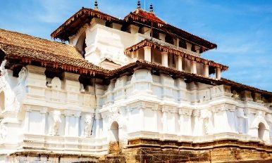
Lankathilaka Viharaya welcomed me with two towering walls on both sides of the path leading to the iconic Buddha statue.   This clay-brick statue of Buddha has been lying headless for centuries now. It could be wear and tear or vandalism, leaving such a magnificent work of art destroyed.   Luckily. I reached Lankathilaka Viharaya on a weekday morning, and it was before the tourist buses arrived.  So, I enjoyed the calm ambiance of the image house and the other surrounding ruins in the complex.   On the way to the image house, I noticed many ruins, including stupas and small pillars, which looked like they had been cut off at the top.   Nevertheless, as I reached the image house, the main attraction of the site, this is what I saw.   Lankathilaka Viharaya At A Glance  Detail Fact Location Alahana Pirivena, Polonnaruwa ancient city, south of Kiri Vehera Builder King Parakramabahu I (1153–1186) Restored Under King Vijayabahu IV (inscription, 1270–1272) Type Gedige (vaulted) brick image house. It used to have five storeys. Height About 17 Meters The tallest entrance pillar is 17.7 Meters.  Wall thickness About 4 Meters Headless Buddha statue Made of clay bricks The original height of the statue was around 12.5 meters.   Time needed 30 to 45 minutes.  My Walk Into The Nave Lankathilaka is in the northern monastic zone of Polonnaruwa.  So, this time I reached it by bicycle from the main ticket office and museum. The rental charge was LKR 400 for a day.   The Approach And The Twin Pillars  The brick pillars framing the entrance were enormous. The tallest pillar still has a height of around 17.7 meters.   The carvings on the pillars were intricate. However, I could not decipher what those figures were.   Inside The Headless Buddha’s Chamber  Barefoot on warm stone, I walked a narrow aisle between walls about 4 meters thick, and the standing Buddha appeared at the far end, cut off above the shoulders.   The chamber does not have a roof. So, daylight completely bathes the statue and the chamber.   Also, the image house has two stairways that lead to the entrance.   Each step is around 4 inches in width and 1 foot in height. Furthermore, the steps run in an ascending order.   So, you have to walk sideways on the steps, avoiding turning your back on the standing Buddha statue. Here, your back will stay against the wall.   The Unique Architectural Style And Elements  The image house has a Geḍi-ge architectural style, in which a semi-spherical or arched-shaped vaulted roof is the signature.   Today, you cannot see the roof. However, the remains speak for the sophistication of the architecture.   Furthermore, I saw the depiction of a Nagini on the balustrade here.   Usually, we see a Naag, or male serpent, with guard stones and a moonstone at any temple entrance.   So, the Nagini structure here is rare.   Here, it is carved on the inner face of the balustrade near the entrance. It has equal hoods as the male counterpart carved on the opposite side.   I am not sure about the interpretations. However, apparently, it looked like the equal role and power of the male and female serpents as guardians of the place.   Light, Sound And Stillness  I was standing halfway down the aisle.   Standing there, I could only listen to my footsteps and distant birdsong. The walls were so thick that they muffled the noise of the outside world.   This silence is what makes the place feel so devotional, even when the scorching rays of the sun reach the chamber and statue without any shelter.   I stayed there for 1 hour, and along with the headless Buddha statue, the Nagini carvings stayed with me.   I come from a land where the divine feminine and the divine masculine are one, and they are incomplete without each other.   Did the Nagini carving opposite the Naag carving here also indicate the same? I am not sure, but I had this thought even after leaving Lankathilaka Viharaya.   History: Why This Image House Exists Polonnaruwa was a royal capital from the 11th to 13th centuries.  Also, King Parakramabahu I turned it into a city of monasteries, reservoirs, and shrines.  Parakramabahu I And The Alahana Pirivena  Lankathilaka was under the Alahana Pirivena monastery.  Also, it is the largest image house of ancient Sri Lanka.   Furthermore, it is one of three gedige shrines at Polonnaruwa, alongside Thuparama and Tivanka.  The Vijayabahu IV Restoration  An inscription records that Vijayabahu IV renovated it about a century later.   These repairs changed a lot of the original architecture of the image house.   Also, if you visit the National Museum in Colombo today, you will find dwarf-like stucco heads from Tivanka and Lankatilaka.  From Abandoned Capital To World Heritage  By the early 14th century, Polonnaruwa had been abandoned, and the jungle slowly covered its monuments until 19th-century excavations began.   UNESCO listed the city in 1982.   Walking the nave today, I found it hard to believe this shell sat under vegetation for centuries.  How Lankathilaka Compares With Polonnaruwa’s Other Gedige Shrines Polonnaruwa has three vaulted image houses, and I visited all three in one day.   Seeing them back to back showed me what makes Lankathilaka special with its sheer scale.  Shrine What stands out Lankathilaka Walls about 17 meters high Colossal headless standing Buddha Thuparama Gedige Best-preserved early brick-and-stone temple, with a barrel-vaulted roof. Tivanka Image House Largest thrice-bent Buddha image, with surviving Jataka murals.  If you only have time for one, I would choose Lankathilaka for drama and Tivanka for painted detail.  Planning Your Visit  Lankathilaka needs no separate ticket as the Polonnaruwa ancient city ticket covers all sites.  Tickets And Timings  Item Detail Foreign adult ticket US$25 Site hours 7 am–6 pm daily CCF ticket counters 7 AM to 5 PM Online tickets Valid for 90 days Guide Charges LKR 2500-3000 for three to four hours.   Pair It With Kiri Vehera And Gal Vihara  Time Stop Notes 7:30 AM Lankathilaka About 40 minutes 8:20 AM Kiri Vehera About 30 minutes 9:00 AM Gal Vihara About 45 minutes  Is Lankathilaka Worth Visiting?  Yes, Lankathilaka Viharaya is worth visiting.  It is compact, and a ticket to this Vihara is included in the ancient city ticket.   Furthermore, for photographers, it is a favorite spot because of the scale it offers. Bring a wide-angle lens or use the ultra-wide mode of your phone to capture the stupa perfectly.   Also, if you are facing a shortage of time, visit Lankathilaka Viharaya on a combined trip to Gal Vihara. 

Manaslu vs Langtang

Manaslu vs Langtang: Which Nepal Trek Is Best For Two Weeks?

BY  Sibashree Bhattacharya Sep 28, 2026

Only got two weeks in Nepal? Then why does choosing a trek suddenly feel harder than choosing what to eat after a long day on the trail? The Manaslu Circuit Trek and Langtang Valley Trek can both put you among some seriously spectacular Himalayan scenery, but they offer very different kinds of adventures. Nepal gives you exactly 14 days. How you spend them depends entirely on your lungs, your legs, and how fast you want to burn through your battery. Do you crave a grueling high-altitude grind? Or maybe a balanced pace, something that leaves breathing room for Kathmandu’s chaotic alleys, Pokhara’s lakeside views, and slow morning coffees. This suits you better. Manaslu vs Langtang: Two paths stand out. However, Manaslu is a beast. It is a sprawling, fiercely remote backcountry commitment that drags you right up to the ragged edge of the Larkya La Pass at 5,106 meters. You will sweat for every single mile. Langtang takes the opposite approach. Think of it as a concentrated shot of pure Himalaya, alpine forests, ancient stone villages, and razor-sharp peaks all colliding into a tight, fast-moving itinerary. You get the iconic Kyanjin Gompa without the endless weeks of approach march. The routes break down like this. Manaslu vs Langtang: The Difference At A Glance Here’s a quick comparison of the two treks. FeatureManaslu Circuit TrekLangtang Valley TrekDurationAround 14–18 daysAround 7–10 daysDifficultyModerate to challengingModerateHighest pointLarkya La, 5,106 mKyanjin area and viewpointsMain highlightRemote circuit and high passLangtang Valley and Himalayan sceneryAccessLonger journey to trailheadEasier accessAtmosphereMore remoteMore establishedBest forLonger Himalayan adventureShorter trekking holiday One important thing jumps out immediately: Manaslu takes more of your holiday. The route involves a lengthy approach to the trailhead, with many days following: The Budhi Gandaki Valley, acclimatization at higher elevations, crossing Larkya La before continuing toward Dharapani. Langtang trims the fat. When you only have two weeks in Nepal, a tighter geographic footprint changes the entire game. You can blitz through the Langtang loop in roughly seven days; that leaves a massive pocket of spare time burning a hole in your pocket. Why rush? We routinely ignore the absolute luxury of empty space on a calendar. Landslides bury mountain roads. Flights stall; muscles fail. Sometimes you just want to get lost in Kathmandu's chaotic, incense-heavy bazaars for another afternoon. A rigid itinerary fractures under the slightest pressure. What Is The Difference Between Manaslu vs Langtang? Forget simple mileage or altitude metrics; the true divide lies in the soul of the march. Manaslu is an expansive, slow-burning odyssey that morphs across shifting ecological zones. Langtang delivers an immediate punch. It funnels you straight into a spectacular glacial amphitheater without demanding weeks of punishing approach marches. Manaslu Circuit Trek Manaslu demands respect. The circuit rings Mount Manaslu via ghost-quiet hamlets, plunging gorges, and raw, fractured alpine topography. The lower trails suffocate in lush subtropical greenery. Then—almost overnight—the forest dies, leaving you exposed on a stark, wind-scoured moonscape. Down in the lower part of the route, you'll see plenty of greenery, but things change as you gain height. The villages show more Tibetan influence, trees become less common, and the mountains seem to take over the whole view. Along the way, you'll come across: Remote Himalayan villages Tibetan-influenced culture The Budhi Gandaki Valley Manaslu mountain views High-altitude landscapes Larkya La Pass Fewer trekkers in some sections of the route And then comes the big moment: Larkya La at 5,106 meters. Once you reach that pass, it feels different from simply arriving at a viewpoint. You have spent days climbing toward it. And the landscape has changed dramatically along the way. That's part of Manaslu's appeal. The destination matters, sure, but the journey is a major part of the experience, and each day feels like another page in the same mountain story. Langtang Valley Trek Langtang feels different from the start. Most trekkers begin near Syabrubesi and follow the valley toward Kyanjin Gompa. Moreover, the trail winds through forests and small villages at first, then the views open up as you climb higher, with bigger peaks appearing around you. Along the way, you can expect: Rhododendron and other forested trails Traditional mountain villages Langtang mountain views Kyanjin Gompa Glacial scenery Snow-covered peaks High viewpoints around Kyanjin Kyanjin begs you to drop your pack. Drop an extra night into the itinerary. You need to explore the immediate crags or go for a steep side-summit if the skies clear and your knees feel good. Moreover, you face no brutal, high-altitude col here; Langtang drops the handcuffs and lets you dictate the mountain rhythm. Why stress? This fluid schedule pays massive dividends when you still need a healthy chunk of time to go feral exploring the rest of Nepal. Which Trek Is More Difficult: Manaslu vs Langtang? Between Manaslu vs Langtang, Manaslu breaks bodies. Strip away the romanticism, and you face a brutal reality. This takes longer days, unyielding vertical gains, and the looming specter of the Larkya La pass. Expect bone-deep exhaustion. Larkya La punches straight up to 5,106 meters; underestimate that thin air at your own peril. Mountain weather plays dirty—whiteouts and flash blizzards instantly turn a standard pass crossing into a high-stakes survival exercise. Do not miscalculate Langtang, though. Furthermore, it is no afternoon promenade; you will spend consecutive, soul-crushing days marching entirely uphill, hammering your quads and forcing your lungs to adapt to the altitude. The shorter distance simply makes the overall trip easier to manage. Here are the main differences: Altitude: Higher on Manaslu Pass crossing: Manaslu includes Larkya La Walking days: Usually longer on Manaslu Terrain: Both have varied mountain trails Acclimatization: Important on both routes Overall commitment: Greater on Manaslu Manaslu vs Langtang Difficulty Langtang offers a remarkably gentle introduction for greenhorns tackling their maiden Himalayan voyage. The logistics feel entirely manageable; the trail spans fewer days. Yet, do not misjudge the thin air. Moreover, short trails do not justify reckless vertical sprinting. Manaslu demands rigorous logistical planning and major time commitments. This is largely because of grueling, high-altitude pass crossings, relentless day-long slogs, and unforgiving weather on the upper ridges. Craving a rugged, multi-day test? If your boots have already survived grueling multi-day backpacking stints, Manaslu brings the exact brand of raw suffering you probably crave. But raw muscular fitness tells only half the story. The ultimate difficulty depends on an intricate web of variables: Your past performance on grueling ten-hour marches, The wisdom in your acclimatization schedule, The unpredictable whims of high-mountain blizzards. Manaslu vs Langtang: Which One Is Best For Mountain Views This is where comparing the two gets interesting. Both routes have incredible mountain views, but the scenery changes in different ways. On Manaslu, you gradually move from green valleys into rough alpine terrain as you climb higher. Langtang covers forests, villages, wide valley views, glaciers, and snowy peaks along a much shorter trail. Manaslu Circuit Trek One memorable thing about the Manaslu route is how noticeably the environment changes as you gain elevation. You begin among greener lower valleys and gradually move into a harsher alpine world. The Budhi Gandaki Valley narrows and grows more dramatic, while enormous peaks begin filling the surrounding skyline. The journey can include: The Manaslu range Deep river valleys Snow-covered Himalayan peaks Alpine terrain Larkya La Remote settlements surrounded by mountains There isn't just one dramatic landscape. The scenery keeps evolving, and that matters because a long trek can sometimes feel repetitive. Moreover, Manaslu counters that by constantly changing the journey's visual character. One morning may feel green and sheltered, while several days later you're walking through an austere high-altitude landscape. Here, rock, snow, and enormous mountain walls dominate everything around you. Langtang Valley Trek Langtang has its own visual personality. Lower sections are wrapped in forests, while the valley gradually opens as you climb. Near Kyanjin, the scenery becomes much more alpine, with snowy peaks and glacial landscapes taking center stage. Highlights include: Langtang Lirung Forested valleys Open alpine landscapes Glacial terrain Kyanjin Gompa Surrounding mountain viewpoints Since Langtang is a shorter trek, you won't pass through as many landscape types as you would on the Manaslu Circuit. Still, that's not really a drawback. Sometimes a shorter route is all you need. You wake up, step outside, see the mountains in front of you, and suddenly the long journey to Nepal feels completely worth it. And the best part? You can enjoy that Himalayan experience without spending your entire two-week holiday on the trail. How Many Days Do You Need For Each Trek? If you have only two weeks, this could be the part that settles the decision. Manaslu uses up a bigger chunk of your holiday, whereas Langtang leaves you with more time for other places and activities. It's also worth counting the travel to and from the trail, acclimatization days, and any unexpected delays instead of focusing only on the days you'll actually spend walking. Manaslu Circuit Trek Itinerary A typical Manaslu Circuit Trek takes around 14–18 days, although the exact length depends on your route, transport, acclimatization days, and walking pace. The trek usually starts around Machha Khola, then follows the Budhi Gandaki Valley through higher settlements before reaching and crossing Larkya La. From there, the trail continues toward Dharapani. Trying to pack the whole journey into too few days can leave you rushing when you should be enjoying the trail. Furthermore, there's one thing you can't negotiate with in the mountains: altitude. Your body needs time to adjust, especially when you're heading above 5,000 meters. Moreover, a well-paced itinerary gives you room to acclimatize and enjoy the villages and scenery instead of spending every evening worrying about how quickly you need to walk the following day. Langtang Valley Trek Itinerary Steering your boots toward the Langtang Valley Trek usually takes about 7 to 10 days, depending on your transport, trail pacing, and whether you detour up nearby ridges. The standard march kicks off around Syabrubesi, snakes up through the belly of the valley to Kyanjin Gompa, then retraces those same steps back down. Furthermore, because this trek wraps up so quickly, Langtang fits like a glove if you only have a tight two-week window for your entire Nepalese escape. That leftover time? It is pure gold. You can easily wander through Kathmandu's chaotic alleys before tying your boots, catch a bus to another destination afterward, or just pocket a buffer day for peace of mind. Moreover, anyone who has ever bounced along Nepal's cliffside roads or watched mountain weather turn on a dime knows things rarely go off without a hitch. Having that extra day up your sleeve keeps you from panicking when the inevitable travel hiccup strikes. Manaslu Circuit Trek vs Langtang Valley Trek: Cost and Accessibility Every single backpacker eventually stares down the barrel of the financial bottom line, wondering just how hard a trek will hit their wallet. Your grand total swings wildly based on trail longevity, bureaucratic permit fees, rugged transit, teahouse lodging, and whether you shell out cash for a seasoned guide or a porter to shoulder your heavy pack. Langtang keeps things refreshingly painless on the bank account. Why? Getting from Kathmandu to the trailhead is relatively straightforward. The journey wraps up quickly. You face far fewer nights of paying for high-altitude beds and hot plates of dal bhat. Manaslu demands a completely different level of pre-trip hustle. Because the government classifies it as a restricted trekking zone, you cannot just wander in. Moreover, you absolutely must secure specialized permits and lock down certified group arrangements beforehand. Even the grueling overland transit to the remote starting point eats up precious calendar days, a logistical hurdle that naturally inflates your upfront expenses. Transportation to and from the trailhead Trekking permits Guide requirements Teahouse accommodation Food and drinks Number of trekking days Porter services, if required Tallying the nightly bill for a solitary Himalayan trail-lodge completely misses the grander financial picture. Both routes rely on local teahouses, yet prices wildly fluctuate based on altitude, season, and amenities. Do not just skim the daily ledger. A cheaper path often bleeds your wallet dry if the itinerary drags on, or if permits and bush-plane transit spike the total. Look at the macro scale instead. To map an honest budget, calculate the expedition as a whole. Stack food, transport, paperwork, and guide services against your total days afield. Which Trek Fits Your Travel Style? This is probably where the choice about Manaslu vs Langtang starts to make a lot more sense. Put the glossy brochures aside for a minute and think about the kind of trip you actually want. Do you like the idea of spending day after day walking farther into the mountains, with the trail becoming a bigger part of your holiday? Or would you prefer a shorter Himalayan trek that still gives you great views, while leaving a few days to explore Kathmandu, head to Pokhara, or see somewhere else in Nepal? There's little point in choosing a route just because it looks impressive on paper. Think about your available time, your hiking experience, and how much of your holiday you want to spend on the trail. Moreover, sometimes the best trek isn't the longest one; it's the one that fits comfortably into the trip you already have in mind. Choose The Manaslu Circuit Trek If You Want: A remote Himalayan adventure A high mountain pass Longer days on the trail A less crowded trekking experience Tibetan-influenced mountain culture A complete circuit-style journey More varied landscapes Manaslu makes particular sense if trekking is the main event of your Nepal holiday. You're not simply popping into the mountains for a few days. You're gradually traveling deeper into the Himalayan landscape and experiencing a route that unfolds over many stages. There is something satisfying about that kind of progression: start lower down, keep walking, gain altitude, cross a major pass, and eventually emerge on the other side of the circuit. Choose The Langtang Valley Trek If You Want: A shorter trek Easier access A first Himalayan trekking experience More flexibility in your itinerary Time for other Nepal destinations A beautiful mountain valley without crossing a high pass Langtang is especially convenient if your two weeks aren't exclusively about trekking. Perhaps you want to spend time exploring Kathmandu's temples and courtyards, maybe Pokhara is on your list, or perhaps you'd like a wildlife trip to Chitwan. With a seven-to-ten-day Langtang itinerary, those options are easier to fit in, and you don't have to turn every day of the holiday into a race against the calendar. Best Time For The Manaslu Circuit Trek And Langtang Valley Trek For both routes, spring and autumn are traditionally popular trekking seasons because conditions are generally more favorable for mountain travel and visibility. Moreover, Spring runs from March to May and can bring milder conditions at lower elevations, along with blooming rhododendrons. [Source: Hiking Nepal] Autumn, particularly September through November, is widely associated with clearer mountain views and generally favorable trekking conditions. Spring: March to May, with warmer conditions and blooming rhododendrons Autumn: September to November, known for clearer mountain views Winter: Colder and snowier at higher elevations Monsoon: Wetter trails, clouds, rain, and possible road disruptions For Manaslu, pay close attention to the weather around Larkya La Pass. Snow and poor visibility can make the crossing much tougher. Thus, it's smart to leave some flexibility in your schedule in case mountain conditions change. Langtang isn't completely free from winter snow either, especially at higher elevations. Moreover, during the monsoon, you may also hit wetter trails, cloudy views, and road delays on the way to or from the trailhead. That's why the season you choose really matters. It shouldn't be something you check a few days before leaving. Checking typical weather conditions, trail conditions, and potential travel delays before booking can make the whole trek much easier to manage. Manaslu Circuit Trek Or Langtang Valley Trek for Two Weeks? Here’s how I’d look at it in practical terms. If your two weeks are mainly about trekking, Manaslu can fit the plan, as long as you leave enough time for acclimatization, transport, and the occasional delay. Most of your holiday will be spent in the mountains, though, so you won't have much room for random detours or last-minute changes. If you want your two weeks to include trekking plus other Nepal experiences, Langtang gives you much more breathing room. Say you have eight or nine days to spend in the mountains. Moreover, that works quite comfortably for Langtang, while fitting Manaslu into the same window would mean keeping a much closer eye on the schedule once transport and acclimatization are factored in. One slow day on the trail, a delayed road journey, or rough weather near a high pass can throw a tightly packed itinerary off balance pretty quickly. Manaslu vs Langtang: Which One Should You Choose? The Manaslu Circuit Trek vs Langtang Valley Trek choice really comes down to what you want from your time in Nepal. Manaslu offers a longer, more remote journey with ever-changing landscapes, villages with strong Tibetan influences, tougher mountain terrain, and the big achievement of crossing Larkya La at 5,106 meters. Langtang, on the other hand, packs a lot into a shorter, easier-to-reach trek, with forest trails, mountain villages, snowy peaks, Kyanjin Gompa, and impressive Himalayan views without tackling a major high pass. Before you book, I'd look beyond those beautiful trekking photos for a moment. Moreover, you need to check how many days you'll actually spend walking and review the altitude profile. You can also consider the transport involved, and be honest with yourself about how comfortable you are with long days in the mountains. Then ask yourself a simple question: Do I want most of my two weeks in Nepal to revolve around the trek, or would I rather make the mountains just one part of a bigger Nepal adventure? answer should make the choice a lot clearer. After that, well, the serious business begins: sorting out your packing list, choosing your teahouses, and pretending you'll stop taking photos after the next spectacular mountain view.

title img

Escapades

“Into the wild, I go. Losing my way but finding my soul.” - John Muir
READ MORE best beaches in Florida Gulf Coast

What Are The Best Beaches In Florida Gulf Coast? Know The Top Names For Every Type Of Traveler

BY  Sibashree May 20, 2026

I have seen the wavy Atlantic side, and now the Florida Gulf Coast stands on the opposite pole of the spectrum.  The turquoise water here is so calm and shallow that you will feel the comfort and familiarity of swimming in a large swimming pool.  Furthermore, the water here is crystal clear, and the beaches have soft while sand. Also, the sunset views from the beaches are amazing.  So, the best beaches in Florida Gulf Coast are ideal for every type of traveler, from families to nature lovers and couples.  Moreover, the activities here are versatile.  You can attend the lively beach pier festivals and explore the hidden gems, perfect for world-class shell collecting.  Also, the emerald-green waters here are ideal for deep-sea fishing.  You can even play with wild dolphins near the shore and gorge on fresh seafood very close to the sand.  If nothing else, you can even relax on the quartz sand that never gets hot enough to burn your feet.  So, you have to just find out the perfect slice of paradise you are looking for.  What Are The Best Beaches In Florida Gulf Coast? A Quick Summary Best Beaches in Florida Gulf Coast Why So Famous?Clearwater BeachSugar-White SandExcellent Family Resorts Lively Night-Pier Festivals Siesta Key Beach99% Pure Quartz SandThe Stays Cool Even In The Hot Sun Naples BeachFrequent Dolphin SightingsHigh-End DiningHistoric Pier ViewsOverall, a Luxury Atmosphere Sanibel IslandWorld-Class Shelling DestinationPristine NatureQuet, Laid-Back VibeDestin BeachDazzling Emerald Green WaterWorld’s Luckiest Fishing VillageAnna Maria IslandA Hidden GemStrict Building LimitsPreserving Old-Florida CharmUncrowded Stores Pensacola BeachStriking Eco TrailsBudget-Friendly LodgingProtected Gulf Islands National Seashore A Detailed Discussion On The Best Beaches In Florida Gulf Coast  Having shared the list of the best beaches in Florida Gulf Coast, I now want to delve deeper. So, here is more about why you will love the best beaches in the Florida Gulf Coast.  1. Clearwater Beach With its vibrant atmosphere and wide shorelines, Clearwater Beach has been one of the top beaches in America, fetching ranks among the top beaches in America.  Furthermore, it is the ideal destination if you want a fusion of city amenities and beach relaxation.  Moreover, it has the famous Pier 60, which makes the nightlife in Clearwater Beach the most happening.  • Best Activities In Clearwater Beach  Parasailing, jet-skiing, taking pirate-themed boat cruises, and watching the nightly sunset celebrations at the pier are the best things to do in Clearwater Beach.  • Clearwater Beach Nearby Attractions  You can visit the Clearwater Marine Aquarium, Caladesi Island State Park, and Captain Bligh's Landing Mini Golf near Clearwater Beach.  • What Is The Best Time To Visit Clearwater Beach?  March to May is the ideal time to visit Clearwater Beach. The weather remains warm in these months.  However, the summer is not intense yet, and there is still time for the humidity to shoot up and storms to arrive suddenly in the afternoon.  • Who Is Clearwater Beach Best For?  Clearwater Beach is the best for families with children, young couples, and solo travelers who enjoy a bustling resort-town atmosphere. • Parking Info Parking at Clearwater Beach can be challenging.  However, you can use the public parking garages on Coronado Drive or catch the Clearwater Ferry to skip traffic. I opted for the latter.  • Water Clarity The water here is very clear, calm, and shallow.  Furthermore, the brilliant light blue hue makes it perfect for wading.  • Restaurants Nearby The restaurants near Clearwater Beach are Frenchy’s Rockaway Grill (famous for grouper sandwiches), Palm Pavilion Beachside Grill, and Ocean Hai. 2. Siesta Key Beach Siesta Key Beach near Sarasota has earned a global reputation thanks to its distinct sand composition.  With 99% pure quartz, the sand looks like powdered sugar, and it does not get hot even when the Sun is scorching.  Furthermore, it has a massive playground, professional tennis courts, a large concession pavilion, and highly active lifeguards, creating a highly active and safe environment for families.  In addition, the wide-open western view of the beach offers flawless sunsets. This stunning sunset view here is often celebrated with the local Sunday night Siesta Key Drum Circle.  Popular Activities  The Siesta Key Beach is popular for a host of water sports, including kayaking, stand-up paddleboarding, and snorkeling near the Point of Rocks area. 3. Naples Beach High-end sophistication meets natural coastal beauty in Naples Beach. It promises a quiet, refined, and more luxurious vacation experience.  Luxury Atmosphere  Backed by million-dollar mansions, manicured parks, high-end boutiques, and upscale golf resorts, Naples Beach offers the most luxurious experience.  Naples Pier  The historic pier of Naples Beach extends into the Gulf. Thus, it is an ideal spot for walking, fishing, and viewing the coast.  Romantic Travel Angle  You can choose Naples Beach for a romantic date as it is the place where couples can enjoy sunset strolls, fine oceanfront dining, and book luxury spa treatments. Dolphin Spotting  Naples Beach is ideal for dolphin spotting, as you can find dolphins frequently swimming close to the shorelines.  You can easily find them from the beach or the pier.  4. Sanibel Island Sanibel Island is an eco-focused paradise. It stretches from east to west instead of north to south.  Due to this unique geography, the island acts as a natural banana-shaped scoop for treasures from the Gulf.  • Shell Collection Sanibel Island is known as the "Shelling Capital of the World.” Here, people practice the Sanibel Stoop to gather rare shells.  • Nature Lovers  The island has no traffic lights or high-rise buildings. Thus, it enjoys a raw and authentic coastal environment.  Furthermore, the lack of light pollution makes it ideal for stargazing.  • Wildlife Refuges  Over half of Sanibel Island is protected. The J.N. "Ding" Darling National Wildlife Refuge especially demands special attention.  It is home to manatees and roseate spoonbills.  • Quiet Beaches  Sanibel Island has quiet beaches that offer complete solitude. For example, Bowman's Beach offers absolute solitude.  Fortunately, many beaches on the island are not commercialized, and there will be no music and crowds.  5. Destin Beach Destin Beach is in the Florida Panhandle. It showcases a dramatic landscape shift, and the amazing color of the water here creates the magic of the Caribbean.  Emerald Green Water Destin Beach has a combination of pure Appalachian quartz sand and shallow water. Furthermore, the water here looks bright emerald in color.  Fishing Opportunities  Destin Beach is home to the largest charter fishing fleet in the state. Furthemore, it offers world-class deep-sea fishing excursions.  Adventure Activities  Snorkeling at the Destin Jetties, renting pontoon boats, and exploring the famous, lively Crab Island sandbar are the best adventure activities here. 6. Anna Maria Island You will go on a trip back in time in Anna Maria. You will not find fast food chains or tall condo buildings here, thanks to the strict local laws.  Thus, the island remains peaceful. Also, thanks to the lack of a crowd, the island enjoys a slow pace of life, and the beaches here are devoid of massive tourist crowds.  Furthermore, I loved getting around Anna Maria Island on bicycles, and you can even take a free island trolley to move around.  Also, you will find locally owned boutiques and donut shops on Pine Avenue.  Moreover, you can read a book under an umbrella, walk along peaceful shores, and escape modern city noise. 7. Pensacola Beach Pensacola Beach is on Santa Rosa Island. It stands out with a fusion of a rich military history and the pristine appeal of the national park coastlines.  Moreover, Pensacola Beach is one of the most budget-friendly beaches on the Florida Gulf Coast. You will find affordable beachfront hotels, condo rentals, and dining options compared to those in Southwest Florida.  Furthemore, the Pensacola Beach Boardwalk, the historic Fort Pickens, and regular spectacular airshows by the Blue Angels are the prime family attractions.  In addition, it is bordered by miles of protected, footprint-free sand dunes within the Gulf Islands National Seashore, which offer the most amazing Gulf views.  What Are The Best Florida Gulf Coast Beaches For Families?  Are you traveling with your family, especially with your children?  Then, you have to choose beaches that have calm waves, convenient amenities, and offer  maximum safety.  In this context, Clearwater Beach can be an excellent choice as it has central lifeguards, shallow drop-offs, and endless beachfront playgrounds.  On the other hand, Siesta Key Beach, with its quartz sand, ensures that children can roam around the sands comfortably and without the fear of burning their feet. This beach also has excellent picnic areas.  Moreover, if you are looking for a budget-friendly option, Pensacola Beach is an amazing choice.  What Are The Quietest Beaches On The Florida Gulf Coast?  If you want to escape the crowds, blaring music, and jet-ski traffic, Sanibel Island is the best place to visit.  Here, nature takes center stage.  Secondly, Anna Maria Island is a popular choice, and it offers miles of residential, tranquil shoreline. You will not find high-rise commercial resorts.  Moreover, if you want to find a true hidden gem, you can visit Pass-a-Grille Beach at the southern tip of St. Pete Beach, which offers a historic, sleepy beach-town atmosphere.  What Are The Best Florida Gulf Coast Beaches For Couples? If you are planning a romantic getaway with upscale experiences, Naples Beach will be the best place to visit.  I loved the sunset at Naples Beach, and it has historic piers.  Furthermore, you have to take a few steps from the water to find a world-class fine dining facility.  Another romantic beach destination for couples is Captiva Island. It is just north of Sanibel.  This island has a secluded vibe, and you will find many sunset cruises and romantic rental cottages.  In addition, Longboat Key near Sarasota comes with quiet, private, and beachfront resorts. These resorts are ideal for couples who want seamless relaxation. What Is The Prettiest Beach On The Florida Gulf Coast? Siesta Key Beach is widely considered the prettiest due to its dazzling white sand made of pure quartz.  striking contrast between the powder-white shoreline and the calm, light-blue Gulf water creates a breathtaking, picture-perfect tropical landscape. Which Gulf Coast Beach Has The Clearest Water? Destin Beach and the Emerald Coast region feature the clearest water.  The lack of river runoff combined with a unique offshore current keeps the water brilliantly transparent, reflecting a gorgeous, Caribbean-like emerald-green hue. Are Florida Gulf Coast Beaches Better Than Atlantic Coast Beaches? Yes, for travelers prioritizing relaxation, the Florida Gulf Coast beaches are the better choice.  The Gulf Coast offers significantly calmer water, softer sand, warmer sea temperatures, and stunning nightly sunsets.  The Atlantic Coast is better suited for surfing, big waves, and sunrises. What Is The Best Time To Visit Florida Gulf Coast Beaches?  Here is a season-wise breakdown of the best time to visit Florida Gulf Coast beaches.  The Best Time To Visit Florida Gulf Coast Beaches Florida Gulf Beaches Conditions Spring (March to May) The Best Time to VisitWarm TemperaturePleasant WeatherMinimal RainSummer (June to August)Very Hot and HumidDaily Afternoon ThunderstormsHigher Crowds of Families Due to Summer BreaksAutumn (September–November)Warm WeatherLower Hotel Rates Daily Weather Can Change Winter (December–February)Mild and Dry WeatherChilly Weather, Not Suitable for SwimmingPerfect for Snowbirds, Sightseeing, and Shelling Hurricane Season Tips  The Hurricane Season in Florida starts from 1st June and continues till 30th November. Furthermore, the hurricane activity takes place in August and September.  So, if you are planning a visit during these months, you must check regular updates from the National Hurricane Center.  Budget Advice  You must travel to Florida Beaches in late April, May, or October to find the best balance of lower accommodation rates and great beach weather. What Are The Things To Do On Florida Gulf Coast Beaches?  Dolphin Cruises: Book a catamaran tour to watch wild bottlenose dolphins jump through boat wakes. Snorkeling: Explore sunken ruins, artificial reefs, and look for sea turtles near rocky points. Paddleboarding: Rent a board to glide over the calm, glassy morning waters of the Gulf. Sunset Watching: Gather on the sand facing west to witness vibrant orange, pink, and purple horizons. Shell Collecting: Walk the tide lines at sunrise to find sand dollars, olives, and conch shells. Fishing: Drop a line off a historic wooden pier or hire a deep-sea charter boat. Getting To The Florida Gulf Coast: Best Airports To Fly Into Picking the right airport can save hours of driving once you land, since the Gulf Coast stretches across several hundred miles of Florida's western edge.  Tampa International Airport  Tampa International Airport is the most convenient hub for the northern Gulf beaches.   It sits roughly 25 to 30 minutes from Clearwater Beach and about an hour from Siesta Key and Anna Maria Island, making it the best choice if your trip centers on the Tampa Bay area or Sarasota.  Southwest Florida International Airport   Southwest Florida International Airport in Fort Myers is the better option for Sanibel Island and Naples Beach, putting you within 30 to 45 minutes of both, compared to the two-plus hours it would take from Tampa.  Northwest Florida Beaches International Airport And Destin-Fort Walton Beach Airport   For Destin Beach and the Emerald Coast, Northwest Florida Beaches International Airport near Panama City and Destin-Fort Walton Beach Airport both sit within a 30-minute drive of the beach.  They are far more convenient than routing through Pensacola or Tallahassee.  Pensacola International Airport  Pensacola International Airport is naturally the closest option for Pensacola Beach and the Gulf Islands National Seashore, generally under 20 minutes from the sand.  If your itinerary spans multiple beach towns, flying into Tampa and driving south along US-41 or I-75 lets you string together Clearwater, Siesta Key, and Sanibel Island in one loop without backtracking.   Renting a car is close to essential for this kind of multi-beach trip, since public transit along the Gulf Coast is limited outside the trolley systems that operate within individual beach towns.  Fares into Tampa and Fort Myers tend to be the most competitive of the group, since both airports carry heavier low-cost-carrier traffic.  Destin and Pensacola routes are comparatively thinner and can carry a premium, particularly during the June-to-August peak season.   Booking flights three to four months out, and mid-week if your schedule allows it, generally produces the better fares across all four airports.  Travel Tips For Visiting Best Florida Gulf Coast Beaches Parking is a genuine problem for visiting most Florida Gulf Coast beaches. So, you want to find a decent parking spot, and you can reach the beaches before 9 AM on the weekend.  You can even use local beach trolleys to avoid full lots.  Moreover, you have to be careful about the beach regulations. Using glass bottles, drinking alcohol, and using open fires are prohibited on most Gulf beaches.  Also, not every beach in the Florida Gulf Coast is pet-friendly. Especially public beaches, such as Siesta Key, have strict guidelines regarding the prohibition of pets.  So, if you want to enjoy a beach holiday with your pet, choose places such as Fort De Soto Dog Beach, Davis Islands Dog Beach, Brohard Paw Park & Beach, and Bonita Beach Dog Park. Read Also: The Ultimate Jaffna Beach Guide: What Are The Best Beaches Near Jaffna, Sri Lanka? Which Is The Best Tropical Beach In The World? Top 10 Best Tropical Beaches Top 10 Naples Italy Beaches You Can’t Miss!

READ MORE how is it possible for ski jumpers to stay in the air so long and how do they train for that

How Is It Possible For Ski Jumpers To Stay In The Air Long And How To They Train For That?

BY  Sibashree May 18, 2026

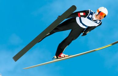
Suppose we jump high in the air. We can stay in the air for around half a second. Michael Jordan could even stay off the ground for only one second.  Now, at many events at the Winter Olympics, we see athletes showing strength and athleticism in the air.  However, ski jumping beats them all in terms of jumping high in the air and staying afloat for so long.  Here, you need to understand the physics of sports. Also, for many of us, the ski jump is a mesmerizing event in the Winter Games, showcasing sports physics in action.  The athlete who travels the farthest and shows the best style while flying and landing becomes the winner of the event.  Ski jumpers can fight gravity, and they can turn their bodies and skis into a wing to stay in the air for 5 to 7 seconds.  Within that span, they can travel almost the length of a football field while staying in the air.  But how is it possible for ski jumpers to stay in the air so long, and how do they train for that?  Let’s delve into the details.  How To Fly?  The answer lies in three important concepts of sports physics.  These are drag, lift, and gravity.  Gravity is the force that pulls any object in flight down. Gravity is a force that works on everybody, and ski jumpers cannot avoid it.  However, ski jumpers, as they move, interact with the air. Now, this interaction further produces lift.  Lift refers to an upward force projected by the air for an upward movement of an object.  In this scenario, if the force of gravity and the force of lift balance each other, an object can fly or glide.  However, producing lift is only possible when the object is moving. Moving objects collide with air particles and push them aside.  Pushing air downward creates an equal, upward reaction known as lift. Here it follows Newton’s third law “For every action, there is an equal and opposite reaction.” You can increase lift by boosting your speed, expanding your surface area, or optimizing your angle of attack (the object's tilt against the airflow).  If this angle is too flat, you generate no lift. If it is too steep, the object stalls.              The Car Window Example  If the concept feels complicated, you can experience the same by just sticking your hand out of a moving car window.  If you keep your hand perfectly flat, it will yield no movement.  However, if you tilt your palm slightly upward, it will force the incoming wind downward. Thus, your hand will be pushed up immediately.  It is a clear example of lift.  The same particle collisions that generate lift also create drag. Drag is a resistive force that slows objects down.  As an object loses speed, its lift drops, cutting the flight short. Because of this, ski jumpers use highly precise body positions to maximize their lift while minimizing speed-killing drag. A Brief History Of The V-Style  The history of ski jumping goes back to the 1800s. Norwegian skiers first started competing for distance on snowy slopes. However, for most of the sport's history, jumpers kept their skis pressed tightly together, parallel to each other, all the way through the flight. The 1980s brought a major change to these practices.  A Swedish jumper named Jan Boklöv began spreading his skis apart mid-air, forming the V-shape you now see in every competition. He drew criticism from experts and judges who considered it a “bad style” because it looked unconventional.  However, Boklöv's V-style increased his jump distances by as much as 10%, simply by giving his body and skis more surface area to catch the air. Then, ignoring the style was impossible.  Within a few years, every serious competitor had switched to the V-style, and judges stopped penalizing it. Even today, it remains a standard technique, and it is the same aerodynamic principle that more surface area means more lift. How To Fly On Skis?  We need to observe the skiers to understand how it is possible for ski jumpers to stay in the air so long and how they train for that. You will see a skier starting on a high slope, and then they move downhill. They generate speed by skiing in this way.  They also reduce drag by squatting and steer very carefully to minimize the friction between the ramp and skis.  So, when they reach the end, the speed will be close to 60 miles or 96 kms per hour.  Once airborne, ski jumpers use aerodynamics to fight gravity and extend their flight.  While they cannot generate enough lift to stay in the air indefinitely, maximizing this upward force slows their descent and carries them further down the hill. To achieve the longest flight possible, athletes lean forward until their bodies and skis are nearly parallel to the snow.  By spreading their skis into a V-shape just outside their body's silhouette, they gain two major aerodynamic advantages. The spread position creates a larger surface area to catch the wind and generate lift. So they get an expanded surface area.  They also get an optimal angle of attack. The forward tilt places them at the perfect angle relative to the airflow to maximize upward pressure. As the jumper glides forward, drag continuously pushes back against them, draining their forward momentum.  Because lift relies entirely on speed, this deceleration causes the upward force to fade away. As drag robs the athlete of their speed, gravity takes complete control, pulling them faster and faster toward the landing zone. The Takeoff: The Hardest Half-Second Out of everything a ski jumper does, takeoff is the most difficult skill to master. It happens in under half a second.  Furthermore, when the jumper reaches the end of the ramp, known as the "table," they must explosively extend their legs and spring forward and slightly upward. They will do it all while still moving at nearly 60 miles per hour. However, if they jump too early, they will lose speed and distance. Once again, jumping too late can cause a loss of control of their body position in the air, which can be dangerous. In addition, the takeoff also sets the jumper's angle of attack for the entire flight.  Because there's no way to make major corrections once airborne, a fraction-of-a-second error in the takeoff can throw off the aerodynamic position for the whole jump.  This is why ski jumpers spend years drilling this single movement until it becomes automatic. How Ski Jumpers Actually Train? Physics explains the reason why ski jumpers fly so far. However, the training behind it is equally crucial.  Training AreaWhat It InvolvesWhy It MattersStrength and Explosive PowerSquats, box jumps, and plyometric drillsBuilds the fast-twitch power needed for the powerful, split-second leg extension at takeoffSummer Training on Artificial TracksYear-round practice on in-run tracks covered with porcelain or plastic bristles instead of snowLet athletes drill their approach, takeoff, and body position even outside the winter monthsWind Tunnel SessionsFine-tuning arm position, back angle, and ski spread with coachesFlight position is highly sensitive to drag and lift, so small posture adjustments can shave off dragVideo and Biomechanical AnalysisFrame-by-frame review of the in-run, takeoff, flight, and landing from multiple camera anglesHelps compare an athlete's actual form against ideal aerodynamic positionsMental PreparationVisualization techniques and gradual exposure, starting on smaller hills and building up to normal and large hillsBuilds the psychological conditioning needed to launch off a mountainside ramp at speed How Do Judges Score A Jump? The judges will not just assess the ski jump based on the distance covered. So, the question of who becomes the winner depends on the distance and the style.  Scoring ComponentHow It WorksPurposeDistance Points• Measured against the K-point (a reference point on the hill). • Landing exactly on it earns a fixed score, with points added or subtracted for every meter beyond or short of it.Rewards how far the athlete actually travelsStyle Points•Five judges score the flight and landing, including body position in the air and control of the landing in the "telemark" position (one foot in front of the other, knees bent). •Each judge scores up to 20 points; the highest and lowest scores are dropped, and the middle three are added to the distance score.Rewards technique and control, not just distance.Gate and Wind CompensationOfficials apply point adjustments in real time based on wind conditions, since headwinds increase lift and tailwinds reduce it.Prevents a gust of wind from unfairly helping or hurting a competitor's final score. Normal Hill Vs. Large Hill Vs. Ski Flying Not all ski jumps are the same size, and the hill itself determines how far a "long" jump actually is. Hill TypeK-Point (Target Landing Distance)NotesNormal HillUp to 109 metersSmaller competition hillLarge Hill110–184 metersUsed for most Olympic ski jumping eventsSki Flying Hill185 meters or moreIt is a separate discipline where athletes can stay airborne longer, sometimes covering well over 200 meters. The larger the hill, the faster the in-run speed and the longer the flight. That is why ski flying produces the most extreme examples of the physics described earlier. It is maximum lift, sustained over the longest possible time. Record-Breaking Flights The current men's ski flying world record stands at 254.5 meters. Domen Prevc completed it in Planica, Slovenia, on 30 March 2025. (Source: Guinness World Records).  Among women’s ski flying, Nika Prevc holds the record. She completed the jump of 236 meters in Vikersund, Norway, on 14 March 2025. These extreme distances are a direct demonstration of the lift-versus-drag balance. The longer an athlete can hold an efficient aerodynamic position without losing speed to drag, the farther gravity has to work to finally pull them down. How Is It Possible For Ski Jumpers To Stay In The Air Long? The Rules Follow The Physics So, you can see there is pure physics at play behind how it is possible for ski jumpers to stay in the air so long and how they train for that.  However, the body of an athlete, equipment choices, and the wind can impact the quality of the jump in many ways.  Also, there are a lot of rules and regulations to keep a ski jump fair.  You will see many officials changing the starting and ending points up and down the slope during the events.  This adjustment happens to ensure a safe landing, depending on the speed of the wind.  When the headwinds are faster, there will be more lift and longer jumps. As a result, an athlete can go past the safe zone for landing.  Moreover, the regulations of a ski jump will also depend on the height and weight of a skier.  Usually, skis have to be “145% of the skier's height.” Also, if the skier has a body mass index of less than 21, they will get shorter skis.  Again, long skis are not the best in every case. When the ski is heavy, you will need more lift to fly and stay in the air.  Also, you have to wear a tight-fitting suit. You cannot wear anything that will need additional lift.  So, when you see a skiing event, think of how the skiers have also mastered the concept of physics. Why Is Ski Jumping Riskier Than It Looks? Ski jumping looks graceful. However, we cannot undermine how physically demanding and risky the sport is.  Athletes fly through the air at highway speeds with only their skis and body position keeping them stable.  A poor landing, a sudden gust of crosswind, or a small error in the takeoff can cause a loss of balance that's difficult to correct mid-flight.  This is part of why regulations are so strict. The rules on suit tightness, ski length relative to height and BMI, and the ability of officials to adjust the start gate are all safety and fairness measures. Wind is the biggest variable officials can't fully control. Which is why competitions are sometimes paused or delayed when crosswinds pick up. It is also why the point-compensation system exists to account for conditions that shift mid-competition. How Is It Possible For Ski Jumpers To Stay In The Air Long? Some Quick Questions And Answers Here are some quick questions and answers related to how ski jumpers stay in the air for long. 1. Why Do Ski Jumpers Spread Their Skis Into A V-Shape? It increases their surface area and creates a better angle of attack, both of which generate more lift and let them fly farther. 2. How Fast Do Ski Jumpers Go Before Takeoff? Around 60 miles per hour (96 km/h) by the time they reach the end of the ramp. 3. How Long Do Ski Jumpers Actually Stay In The Air?  Roughly 5 to 7 seconds in standard competition, and even longer during ski flying events on the largest hills. 4. Is Ski Jumping Scored Only On Distance?  No. Final scores combine distance points with style points awarded by judges for body position and landing control. 5. What Is The Difference Between Ski Jumping And Ski Flying?  Ski flying happens on larger hills built for greater distances. It allows longer flights and higher speeds than standard normal or large hill ski jumping. Read Also: Car Travel On PaxTravelTweaks: How Does It Help In Smartly Planning Budget-Friendly Road Trips? IWantThatFlight Offering Cheap Flights: The Best Hack For Traveling On A Budget

READ MORE best places for whale watching California

What Are The Best Places For Whale Watching California? Know The Prime Locations 

BY  Sibashree May 18, 2026

Key Takeaways For Whale Watching In California  1. Southern California is an ideal destination for whale watching throughout the year. Furthermore, you can spot different species of whales at various times of the year. 2. Monterey Bay in Central California is the most prominent spot for whale watching. The deep submarine canyon makes it an ideal place for whale spotting. 3. The Gulf of the Farallones in Northern California is another important place for whale watching in California. It is a unique combination of diverse marine life and a marine sanctuary. You can spot whales here from the month of December to May. California is the best state in the USA for spotting whales.  Furthermore, according to the report of Ocean Today, “Today, nearly 24,000 gray whales continue their annual migration along the coast of North America, giving humans a glimpse of these majestic creatures that live in the deep.” These whales come from the waters of Alaska, and they travel for 6000 miles to reach the Mexican bays in the winter.  The balmy bays and waters offer the ideal conditions for mating for these whales.  Furthermore, in the spring season, these whales take the calves to the north while traveling along the California coast.  What Are The Best Places For Whale Watching California?  If you are planning whale watching in California, you can wait for the most mesmerizing experience.  While gray whales are the prime attractions, you can also spot other types of whales and marine animals in California.  Blue Whales Humpbacks Dolphins  Orcas.  All these marine animals travel from north to south and vice versa along the coast every year.  Moreover, if you are a whale watcher, you will get many opportunities to spot this marine life from Dana Point to Mendocino.  However, each region offers a distinct attraction, and you have to make a timely visit to the right places.  So, what are the right places? Let’s find out, and here, I will start with a quick summary.  California Regions Prime Viewing Spots Peak Season Target Whale SpeciesSouthernDana Point Newport Beach San Diego Year-Round - Gray Whale in Winter- Blue Whale in Summer CentralMonterey Bay Moss Landing Big Sur Year-Round - Humpback Whale- Blue Whale- Gray Whale Orca Northern Point Reyes Farallon Islands Mendocino December to May- Gray Whale- Humpback Whale- Orca  1. Southern California  Southern California is one of the best places for whale watching, as the whales take this route while returning to Alaska in the springtime.  Furthermore, in Southern California, the important spots for whale watching are: La Jolla Cove Dana Point Channel Island Moreover, the La Jolla Cove, among others, is a part of the San Diego-La Jolla Underwater Park Ecological Reserve.  Also, you can reach the La Jolla Cave after taking a 15-minute drive from the amazing Scripps Institution of Oceanography. This institute remains open to the public.  Best Time For Whale Watching In Southern California  Southern California is ideal for year-round whale watching. Here, I am quoting what Wesley Turner, a “former marine science educator associated with Newport Landing Whale Watching,” shared on Travel+Leisure.  She said,  “I do not believe there is a best time of year to come out whale watching in Southern California.” She also added that different species of marine life rule the waters at different times. Nevertheless, if you want to spot sea lions, dolphins, humpback whales, and gray whales in California, you must visit between January and April.  Again, May to September is the best time for spotting finback whales and blue whales.  Moreover, if you want to spot minke whales, you can plan a trip between May and September.  2. Central California  During a morning whale-watching tour from Monterey Harbor, humpbacks were visible within 20 minutes of leaving the dock. The submarine canyon here goes up to 2.5 miles at its greatest depth, and it is the reason why Monterey is so rich as a marine mammal habitat.  Moreover, the canyon here is just offshore. So, you do not always need to get into the boat to spot marine life.  In fact, if you are doing a road trip around Big Sur, you can spot whales from the clifftop roads along the Pacific Coast Highway.  Prime shore-vantage points include the dramatic headlands of Point Lobos State Natural Reserve and the trail overlooks at Garrapata State Park.  The visibility from Point Lobos was surprisingly good, although binoculars helped considerably. However, if you are planning whale watching from the cliff top, you will need patience. You can relax and dine in seaside restaurants such as Sierra Mar and wait for the whales or marine animals to appear.  For a closer look, daily boat tours depart right from Old Fisherman's Wharf in Monterey.  The Experience With Monterey Bay Whale Watch  Moreover, Monterey Bay Whale Watch is a company operated by Nancy Black. Nancy is a marine biologist, and she offers a four-hour excursion daily for spotting the whales.  She has worked with whales for 30 years. So, you know what kind of experience you have on board.  Her team specializes in tracking the bay's famous spring Orca pods as they enter the canyon to hunt.  Moss Landing Also, Moss Landing is the heart of the Monterey Bay, where the submarine canyon begins. Because the deep water starts right at the pier, you can often see humpbacks feeding just off the beach, alongside the local sea otters of Elkhorn Slough.  In addition, San Simeon and Avila Beach are excellent vantage points in the region. What Is The Best Time For Whale Watching In Central California  Monterey Bay, in the truest sense, is a year-round destination for whale watching. However, the best time to visit will depend on the type of species you want to visit.  For example, April to November is the ideal time for spotting blue whales and humpback whales.  On the other hand, if you want to see migrating gray whales, December to April is the ideal time.  3. Northern California  Do not waste your time on whale watching in San Francisco Bay. Or, do not expect the whales to swim beneath the Golden Gate Bridge.  Instead, you can travel 25 miles from the coast, and there, you will find the Gulf of the Farallones.  It is a marine sanctuary, covering an area of 3295 square miles. Furthermore, a minimum of 25 species of threatened or endangered species breed and are fed here. Also, it has thirty-six mammal species, including the following names.  Humpback Whales Gray Whales Blue Whales Pacific White-Sided Dolphins Sea Lions Harbor Seals.  Moreover, here you will find an important white shark population.  Also, the Outdoor Adventure Club, organizing different kayak tours for whale watching, is ideal for people looking for a serious adrenaline rush.  This tour takes place near Davenport Landing, which is at a distance of 65 miles from San Francisco.  Moreover, the Mendocino Coast is located north of San Francisco. It is ideal for hiking along the Mendocino Headlands State Park and spotting whales.  What Is The Best Time For Whale Watching In Northern California? December to May is the best time for whale watching in Northern California if you are planning to see orcas and gray whales.  In addition, May to November is the ideal time to spot humpback whales. Moreover, July to October is the best time for spotting blue whales.  Top Shore-Based Whale Watching Locations In California  If you do not want to go on a boat ride for whale watching, you can choose the following destinations. 1. Point Dume (Malibu)  Point Dume rises dramatically over the Santa Monica Bay. This Malibu highland is an incredible vantage point for gray whales, which are migrating close to the beach. December to April is the ideal time for whale watching from this vantage point. Also, you can spot blows and breaches clearly from these cliffside trails without binoculars. Moreover, from here, you can spot local pods of bottlenose dolphins playing in the surf below. 2. Point Vicente (Palos Verdes)  Point Vicente is the home to the annual whale count of the Los Angeles Littoral Society. Furthermore, the interpretive center of this rocky peninsula sits on a high bluff, offering unobstructed, panoramic views of the Pacific Ocean.  Also, the whales here pass very close to the rocky shoreline as the whale migration path starts becoming narrower after this point. 3. Bodega Head (Sonoma County)  Bodega Head is a magnificent granite promontory that looks prehistoric as it juts out into the ocean. So, standing on it felt like I was directly in the path of the migrating marine life. Furthermore, as it offers sweeping views of the Pacific Ocean, it becomes easier to spot humpbacks in the summer and gray whales in the winter. Volunteer docents often set up scopes here on weekends to help visitors scan the water.  4. Mendocino Headlands State Park  Mendocino Headlands State Park has windswept cliffs surrounding the historic village of Mendocino and accessible walking trails. The high coastal bluffs are ideal platforms for spotting gray mother whales guiding their new calves to the north in the springtime. Furthermore, thanks to the sheer drop-offs, the whales come very close to the crashing whitewater below. 5. Garrapata State Park (Big Sur)  The Garrapata State Park is on the northern edge of the Big Sur coast. You can take any of the oceanfront trails here that run right along the cliff edge. Due to the steep, elevated topography, the cliff edge offers a perfect natural viewing point platform above the deep water.  A Quick California Whale Watching Calendar  Here is a consolidated calendar for whale watching in California. Know which species you can spot in which month. Months Species To Spot January Gray Whales February Gray Whales March Gray Whales April Gray Whales Humpbacks May Blue Whales June Blue Whales July Blue Whales August Blue Whales Humpbacks September Blue Whales Humpbacks October Humpbacks November Humpbacks December Gray Whales  What Are The Things To Pack For Whale Watching In California?  You have to be prepared if you are planning whale watching in California. You have to carry sunscreen, hats, and sunglasses.  Furthermore, you have to bring motion patches or pill medications to avoid seasickness and other discomfort.  In addition, you will need the right clothing, light, and layers. Most importantly, have the right temperament and patience for spotting whales and other fascinating marine animals. Quick-Reference Tips For First-Time Whale Watching In California  Practical Tips Why It Matters Actionable StrategyTake Motion Sickness Tablets The strong swells of the Pacific Ocean can cause nausea.Take a tablet one hour before the journey starts.Wear Layers The offshore temperatures are 10 to 15 degrees colder than the coastal area.Bring a windproof jacket, a warm beanie, and light gloves. Bring Binoculars Whales often surface far from the boat or deep off the coastal cliffs. Use a waterproof pair of 8x42 or 10x42 binoculars for scanning. Choose Morning Tours Morning sea conditions are calmer, and the winds are gentler.Book the earliest departure time available.Check Weather Forecasts Rough winds and harsh sea conditions often lead to tour cancellations.Look at marine forecasts the night before and call the office to confirm. Arrive Early Parking near popular harbors and boat docks fills up incredibly fast. Arrive at the dock at least 45 to 60 minutes before the journey starts. Responsible Whale-Watching Practices In California You have to follow responsible whale-watching practices in California to avoid disturbing the marine mammals. Also, you have to abide by the National Oceanic and Atmospheric Administration (NOAA) guidelines and choose certified operators for the tours. Here are more details. 1. Follow NOAA Distance Guidelines  The stringent guidelines of NOAA aim to protect the marine mammals from vessel harassment. Federal law requires all boats, kayaks, and jet skis to maintain a minimum distance of 100 yards from whales.  Extending this buffer zone offers additional protection for endangered humpback or blue whales. Furthermore, a whale once approached our vessel on its own. The operator placed the engine in neutral and waited for the animal to swim away safely. This is another NOAA guideline. 2. Never Feed Wildlife According to the Marine Mammal Protection Act, feeding a marine mammal is strictly illegal. Furthermore, when you attempt to feed sea lions, dolphins, or whales, you disrupt their natural foraging instincts and alter their migratory behavior.  Also, this practice conditions wild animals to associate boats with food, which dramatically increases their risk of propeller strikes, net entanglements, and hazardous interactions with humans.  So, you have to keep the trash and food stored inside the vessel. 3. Choose Certified Operators  If you are booking a commercial excursion, you must pick a company dedicated to marine conservation.  That is why you have to look for operators certified by organizations like Whale Sense or those partnered with local marine sanctuaries.  When a tour operator and the captain are responsible, they will prioritize the animal's welfare over close-up photos.  Also, our captain approached all the animals slowly from the side. This is a great move to avoid pinning them against the shoreline. Moreover, when the captains see other boats waiting, they can limit the viewing time to 30 minutes. 4. Avoid Disturbing Migration Routes  Whales travel thousands of miles along the California coast on a very tight, energetic budget. Forcing a whale to change its course or dive prematurely wastes vital energy, which can be catastrophic for mothers traveling with young calves.  Boat operators must never cut off a whale's path, herd a pod, or drive a vessel directly through a group of migrating mammals. Peaceful, parallel observation ensures they reach their destinations safely. Read Also: Loranocarter+California: Is It Worth Visiting The Place? Why Is Sequoia National Park Famous? 6 Best Places To Visit In California

title img

Wanderlust

“I don’t know where I am going. But I’m on my way.” - George Fairman
READ MORE Kiri Vehera

Kiri Vehera, Polonnaruwa: Walking Around Sri Lanka’s Best-Preserved Milk Stupa

BY  Sibashree Sep 29, 2026

I got a glimpse of the Kiri Vehera through a gap in the trees.  It was milky white, and even early in the morning, it looked the brightest among the surrounding ruins.  Also, it is fascinating that the stupa is one of the few in Sri Lanka to have its original structure even after around 900 years.  Locals say that when the stupa was discovered amidst the jungle, its chunam, or lime coating,g was still intact.  Thus, it got its name as Kiri Vehera, or Milk White Stupa.  Furthermore, along with being the best-preserved stupa, it is also a classic example of Bubulakara, or the bubble-shaped form of stupa.  Kiri Vehera At A Glance DetailFactMeaning“Milk Stupa”It was originally called Rupavati Chetiya.BuilderQueen Subhadda, consort of Parakramabahu I (1153–1186)She was also known as Bhaddavati.TypeBubbulakara (bubble-shaped) stupa on three receding terracesHeightAround 24 meters for the damaged stupa. Base diameterAbout 26.8 metersTerraceAbout 57.6 metersRankSecond-largest stupa at PolonnaruwaStatusStill an active place of worshipEntry FeeIncluded in the $25 Polonnaruwa ticket. Hours7 AM to 5:30 PM My Walk Around The Milk Stupa Kiri Vehera is just north of Lankathilaka. I just took a short walk over after the image house to reach this stupa.  First Impressions Of The White Dome As I have mentioned, the white plaster of the dome glowed against the blue sky.  It has the simplest design with very little ornamentation.  Polonnaruwa’s builders kept this design deliberately simple. Small subsidiary stupas dot the platform, and the scale felt human rather than overwhelming. The Devatā Carvings Most People Miss Don’t miss a close look at devatā-koṭuva.  It has the most unusual carvings of deities, and these are uncommon for a stupa.  This drum-like structure has carvings of eight divine figures in a folded-hand posture. It looks like they are worshipping Lord Buddha.  Circling The Stupa With Respect I saw devotees visiting the stupa and offering flowers. They lit oil lamps and walked around the stupa as part of their prayer rituals. Also, you have to keep your shoes outside the brick fence.  History And Architecture The stupa dates to the reign of Parakramabahu I. Furthermore, it is part of the king’s vision to build a large monastic university, Alahana Pirivena.  Also, the building programme of the king helped reshape Polonnaruwa. Queen Bhaddavati And The Rupavati Chetiya The Mahavamsa credits the building of this stupa to Queen Bhaddavati.  As a woman, I appreciated the fact that the best-preserved monument in the ancient city is a queen’s commission, not a king’s. The Terraces And Dimensions  The architectural design of the monument features a stupa positioned directly in the center of an expansive square terrace, with each side stretching roughly 57.6 meters (189 feet).  The main dome spans a diameter of 26.8 meters (88 feet) at its base.  From the ground up to its fractured spire, the entire monument reaches an approximate height of 24 meters (80 feet). Supporting the core structure are three stepped basal terraces, traditionally called pesavas.  Standing between 0.9 and 1.2 meters (3 to 4 feet) high, these tiers likely functioned as pathways for devotional walking rituals (circumambulation) or as ledges for leaving flowers.  This design element directly mirrors ancient Indian architecture seen at historic sites like Sanchi. Sitting atop the dome is the hatareskotuva (a square tee) built from solid brick, measuring about 7.4 meters (24 feet 4 inches) wide and 3.7 meters (12 feet) tall.  Resting directly above this square section is the devata-kotuva (the enclosure of the deities), a rounded drum that is 2.9 meters (9 feet 6 inches) wide and 2.3 meters (7 feet 8 inches) high.  This circular tier is decorated with carvings of eight gods shown praying with their hands joined in deep respect.  The final crowning element is the kota (spire), which extends upward for another 7 meters (23 feet), though fragments of the spire have eroded away over the centuries. The Relic Chambers And The Interior Of The Stupa In the early 1900s, British archaeologist H. C. P. Bell conducted systematic excavations that offered a rare glimpse into the inner architecture of the stupa.  During his investigation, Bell uncovered a winding, 25-foot (7.6-meter) tunnel carved out centuries earlier by grave robbers targeting the structure's sacred treasures.  After clearing out this passageway, his team discovered two upper relic chambers that had unfortunately already been broken into and stripped of their valuables. The first looted chamber spanned roughly 11 feet 2 inches (3.4 meters) wide. It originally housed structural foundations meant to secure a yantragala (a traditional stone reliquary). It also had a sacred Mahameru stone, which serves as a symbolic representation of the cosmic mountain. Crucially, a third, lower chamber escaped destruction.  Because the historical looters had not dug deep enough, this final vault remained perfectly sealed and intact.  Out of preservation and respect, Bell’s archaeological team made the deliberate decision to leave this third chamber unopened. Why The Plaster Survived When the jungle was cleared after roughly 700 years of neglect, the lime plaster was in near-perfect condition.  Engineers describe these plasters as closer to lime-concrete than ordinary stucco.  That waterproof skin explains why brick has not crumbled here as it has elsewhere. Kiri Vehera Vs Rankot Vehera: Two Ways To Read A Stupa I compared Polonnaruwa’s two great stupas on the same day. Each of them has a different mood. Rankot is impressive because of its size, while Kiri Vehera impresses by its survival. FeatureKiri VeheraRankot VeheraBuilderQueen Bhaddavati (12th century)King Nissanka Malla (1187–1196)HeightAbout 24 Meters54 MetersSurfaceOriginal lime plaster largely intactExposed brick, like most stupas of its era.Best forPreservation and quiet worshipSheer scale How I Would Fit It Into A Day I spent about 45 minutes here, then moved on to Gal Vihara before the midday heat.  Also, it is a short walk from Lankathilaka and offers the strongest contrast in appearance. The image house is a ruin, and the Buddha statue there is headless. However, this stupa has had the same structure since the time of its foundation.  Photography Tips With its human scale, Kiri Vehera is a favorite of photo enthusiasts.  However, if you are visiting the stupa mid-day, the mid-day glare will bounce off the white plaster.  On the other hand, morning and late afternoon, with softer light, are better times of the day for photography.  Also, never take selfies posing back to the stupa, as it is disrespectful, and the guides will stop you if you even try to do that.  Why Kiri Vehera Matters Today The ruins of the Anuradhapura Sacred City and other remains of Polonnaruwa raise a question. What did these monuments look like when they were finished?  Kiri Vehera is the only monument to offer an answer to this.  Also, as a living worship shrine, it is a site that allows you to slow down.  So, if you are rushing past it on the way to Gal Vihara, you will miss the quiet centre of the northern complex.

READ MORE lankathilaka viharaya

Lankathilaka Viharaya, Polonnaruwa: Inside Sri Lanka’s Largest Image House

BY  Sibashree Sep 29, 2026

Lankathilaka Viharaya welcomed me with two towering walls on both sides of the path leading to the iconic Buddha statue.   This clay-brick statue of Buddha has been lying headless for centuries now. It could be wear and tear or vandalism, leaving such a magnificent work of art destroyed.   Luckily. I reached Lankathilaka Viharaya on a weekday morning, and it was before the tourist buses arrived.  So, I enjoyed the calm ambiance of the image house and the other surrounding ruins in the complex.   On the way to the image house, I noticed many ruins, including stupas and small pillars, which looked like they had been cut off at the top.   Nevertheless, as I reached the image house, the main attraction of the site, this is what I saw.   Lankathilaka Viharaya At A Glance  Detail Fact Location Alahana Pirivena, Polonnaruwa ancient city, south of Kiri Vehera Builder King Parakramabahu I (1153–1186) Restored Under King Vijayabahu IV (inscription, 1270–1272) Type Gedige (vaulted) brick image house. It used to have five storeys. Height About 17 Meters The tallest entrance pillar is 17.7 Meters.  Wall thickness About 4 Meters Headless Buddha statue Made of clay bricks The original height of the statue was around 12.5 meters.   Time needed 30 to 45 minutes.  My Walk Into The Nave Lankathilaka is in the northern monastic zone of Polonnaruwa.  So, this time I reached it by bicycle from the main ticket office and museum. The rental charge was LKR 400 for a day.   The Approach And The Twin Pillars  The brick pillars framing the entrance were enormous. The tallest pillar still has a height of around 17.7 meters.   The carvings on the pillars were intricate. However, I could not decipher what those figures were.   Inside The Headless Buddha’s Chamber  Barefoot on warm stone, I walked a narrow aisle between walls about 4 meters thick, and the standing Buddha appeared at the far end, cut off above the shoulders.   The chamber does not have a roof. So, daylight completely bathes the statue and the chamber.   Also, the image house has two stairways that lead to the entrance.   Each step is around 4 inches in width and 1 foot in height. Furthermore, the steps run in an ascending order.   So, you have to walk sideways on the steps, avoiding turning your back on the standing Buddha statue. Here, your back will stay against the wall.   The Unique Architectural Style And Elements  The image house has a Geḍi-ge architectural style, in which a semi-spherical or arched-shaped vaulted roof is the signature.   Today, you cannot see the roof. However, the remains speak for the sophistication of the architecture.   Furthermore, I saw the depiction of a Nagini on the balustrade here.   Usually, we see a Naag, or male serpent, with guard stones and a moonstone at any temple entrance.   So, the Nagini structure here is rare.   Here, it is carved on the inner face of the balustrade near the entrance. It has equal hoods as the male counterpart carved on the opposite side.   I am not sure about the interpretations. However, apparently, it looked like the equal role and power of the male and female serpents as guardians of the place.   Light, Sound And Stillness  I was standing halfway down the aisle.   Standing there, I could only listen to my footsteps and distant birdsong. The walls were so thick that they muffled the noise of the outside world.   This silence is what makes the place feel so devotional, even when the scorching rays of the sun reach the chamber and statue without any shelter.   I stayed there for 1 hour, and along with the headless Buddha statue, the Nagini carvings stayed with me.   I come from a land where the divine feminine and the divine masculine are one, and they are incomplete without each other.   Did the Nagini carving opposite the Naag carving here also indicate the same? I am not sure, but I had this thought even after leaving Lankathilaka Viharaya.   History: Why This Image House Exists Polonnaruwa was a royal capital from the 11th to 13th centuries.  Also, King Parakramabahu I turned it into a city of monasteries, reservoirs, and shrines.  Parakramabahu I And The Alahana Pirivena  Lankathilaka was under the Alahana Pirivena monastery.  Also, it is the largest image house of ancient Sri Lanka.   Furthermore, it is one of three gedige shrines at Polonnaruwa, alongside Thuparama and Tivanka.  The Vijayabahu IV Restoration  An inscription records that Vijayabahu IV renovated it about a century later.   These repairs changed a lot of the original architecture of the image house.   Also, if you visit the National Museum in Colombo today, you will find dwarf-like stucco heads from Tivanka and Lankatilaka.  From Abandoned Capital To World Heritage  By the early 14th century, Polonnaruwa had been abandoned, and the jungle slowly covered its monuments until 19th-century excavations began.   UNESCO listed the city in 1982.   Walking the nave today, I found it hard to believe this shell sat under vegetation for centuries.  How Lankathilaka Compares With Polonnaruwa’s Other Gedige Shrines Polonnaruwa has three vaulted image houses, and I visited all three in one day.   Seeing them back to back showed me what makes Lankathilaka special with its sheer scale.  Shrine What stands out Lankathilaka Walls about 17 meters high Colossal headless standing Buddha Thuparama Gedige Best-preserved early brick-and-stone temple, with a barrel-vaulted roof. Tivanka Image House Largest thrice-bent Buddha image, with surviving Jataka murals.  If you only have time for one, I would choose Lankathilaka for drama and Tivanka for painted detail.  Planning Your Visit  Lankathilaka needs no separate ticket as the Polonnaruwa ancient city ticket covers all sites.  Tickets And Timings  Item Detail Foreign adult ticket US$25 Site hours 7 am–6 pm daily CCF ticket counters 7 AM to 5 PM Online tickets Valid for 90 days Guide Charges LKR 2500-3000 for three to four hours.   Pair It With Kiri Vehera And Gal Vihara  Time Stop Notes 7:30 AM Lankathilaka About 40 minutes 8:20 AM Kiri Vehera About 30 minutes 9:00 AM Gal Vihara About 45 minutes  Is Lankathilaka Worth Visiting?  Yes, Lankathilaka Viharaya is worth visiting.  It is compact, and a ticket to this Vihara is included in the ancient city ticket.   Furthermore, for photographers, it is a favorite spot because of the scale it offers. Bring a wide-angle lens or use the ultra-wide mode of your phone to capture the stupa perfectly.   Also, if you are facing a shortage of time, visit Lankathilaka Viharaya on a combined trip to Gal Vihara. 

READ MORE Gal Vihara

Gal Vihara, Polonnaruwa: Sitting Before The Four Rock-Cut Buddhas And Vishnu (2026 Guide)

BY  Sibashree Sep 24, 2026

Gal Vihara drew me in for more than the massive rock-cut Buddhas.  Some may argue that it was a deliberate attempt to showcase Hindu deities as subordinate to Buddha or Buddhist figures.  However, I see this as an effort for political and religious integration.  We know about Gongalegoda Banda, who put up a fight against the British in 1848, which was a decade before the first mass uprising in India in 1857 (The Sepoy Mutiny).  He worshipped Vishnu, not Buddha, before he started the war against the British.  Now, the Gal Vihara in Polonnaruwa is an important landmark where I could see this integration.  Very few notice that the Vijjadhara Guha, the semi-artificial cave for sorcerers, has Lord Vishnu and Lord Brahma as the attendants to Lord Buddha.  In Hinduism, we see the exact opposite version of it, with some versions depicting Lord Buddha as one of the 10 avatars of Lord Vishnu.  That can be a separate discussion. However, in this article, I will discuss what I saw at Gal Vihara, the history, and everything else you need to know.  This is one of the reasons why Sri Lanka gets such a high footfall. For example, Financial Chronicle reported an arrival of 198,235 tourists from January to August 2025. In 2026, the number was 1,535,122 for the same period, according to the Economic Times, LK.  Gal Vihara At A Glance DetailWhat to KnowOriginal nameUttararama, "the northern monastery." Built byKing Parakramabahu I, who reigned 1153–1186 CELocationNorthern part of the ancient city of Polonnaruwa, North Central ProvinceThe imagesFour Buddha images from one granite slab.Two seated, one standing, one reclining.SizesReclining figure about 14 meters long, standing figure about 7 meters tallTicketPart of the Polonnaruwa ticket.Free for locals and US$25 for a foreign adult.$12 for foreign children. Timing7 AM to 5 PMTime needed1–2 hours hereBest timeEarly morning for softer light and fewer people My Time Before The Four Buddhas It was mid-morning when I reached the northern end of the ruins.  I removed my shoes and started walking toward the rock face.  Then I spotted where the walls stood, from the figures that once had their own brick image house and the remains of the low stone foundations.  Figuring out that outline helped me identify how enclosed and dim the images once were, before the walls fell and the sky opened above them. The Seated Buddha I saw the depiction of Lord Buddha in his meditating pose in the cave of the Vijjadharas. It is the leftmost cave among all.  He is the Dharmadhatu or Vairocana, and in the Mahayana tradition, he is worshipped as the cosmic Buddha.  Furthermore, there were four bas-relief Buddhas at the top of the statue and on the sides.  The guide told me that these small statues represent the four directions of the world, and they are the embodiments of Dharmakaya, or the “all-encompassing body of law.”  However, another version says that two of them are Lord Brahma and Lord Vishnu, present as guardian deities to Lord Buddha.  The Excavated Cave And Seated Buddha This cave on the right also has a rock-cut Buddha sculpture in a meditating pose.  The sculpture is modest. However, you must not miss the stone inscription next to this shrine.  It is a record of the religious reforms of King Parakramabahu. Later, he also asked them to draw up a code of conduct, which is recorded in this inscription.  Uttararama is also where Parakramabahu I gathered monks to purify the Buddhist community. The Reclining Buddha The reclining Buddha here depicts entering parinirvana.  It is 14 meters in length, and the details here drew my attention.  There is a gentle dip in the pillow beneath the head. Also, there are lotus symbols on the pillow end and on the soles of the feet. I was dumbstruck and had goosebumps at the same time, standing at the feet and then following the line of the body along the rock.  It was so lively! The Standing Figure And The Ananda Debate Next, I visited the standing Buddha statue where Buddha is standing with his arms crossed over his chest. The facial expression of this 7-meter-tall figure is sorrowful.  The most popular version is that it is the figure of Ananda, the disciple of Buddha. He was grieving as the lord entered parinirvana.  However, another version completely rejects this idea and says that it is Lord Buddha himself.  They find the expression of a subtle smile, and they say that here Lord Buddha is standing after two weeks of his enlightenment.  The History: Parakramabahu I And The Northern Monastery The Culavamsa chronicle credits King Parakramabahu for the construction of Gal Vihara.  He built it to strengthen Theravada Buddhism and unify Sri Lanka.  Natural Marbling As Part Of The Design Carvers used the natural marbling in the granite to create the life-like effect of the sculptures.  In the softer morning light, I could see how the veins in the stone follow the lines of the carving, which is another reason I would visit early. Photography And Respect You can take photographs here. However, it is a sign of disrespect to turn your back to the statues to take selfies.  Furthermore, if you want to film Gal Vihara, you will need prior approval from the authority.  Getting Around Polonnaruwa You must take a cycle or a tuk-tuk between the ruins.  Six to eight hours by bicycle covers the whole site. The charge will be around LKR 400 to LKR 1000 for the entire day.  A Half-Day Itinerary Around Gal Vihara TimeStopNotes7:30 AMTicket office and Polonnaruwa MuseumKnow the context of the ancient city before the ruins.8:30 AMRoyal Palace and QuadrangleVisit the central monuments while it is still cool. 10:30 AMAlahana Pirivena areaVisit the monastic ruins near Gal Vihara.11:30 AMGal ViharaAllow 1 to 2 hours to explore the vihara.1:00 PMLunch and restAvoid peak midday heat.4:30 PMParakrama Samudra shoreObserve the quieter light on the reservoir.  Nearby Places To Combine With Gal Vihara Don’t miss the Polonnaruwa Museum, run by the CCF beside the Parakrama Samudra sluice gate. It houses findings from the excavations at the site since 1981.  Also, if you want a wildlife experience, you can consider Minneriya, which is also amazing for sunset views.  Latest Updates For 2026 Visitors To Gal Vihara The Thuparama Image House in Polonnaruwa, a 12th-century vaulted brick shrine, received US-funded conservation support, announced in January 2025. Furthermore, the CCF now runs an eTicket portal for Sigiriya, Anuradhapura, Polonnaruwa, and other heritage sites. You can purchase these tickets up to 90 days before the visit.

title img

Travelogue

“If we stayed in one place, we’d have roots instead of feet.” - Rachel Wolchin
READ MORE United Airlines flight UA82 emergency

How Does United Airlines Flight UA82 Emergency Change Air Travel?

BY  Sibashree Jun 6, 2026

Today, frequent travelers are forced to think about long-haul travel safety due to the United Airlines flight UA82 emergency.  However, what does the investigation into the Newark-to-Delhi diversion make apparent? What is the impact of the emergency landing on modern air travel? In this article, I will share how systemic cooling failures impact modern wide-body fleets in an advanced “wide-body fleet.” Moreover, this incident shows how increasing operational hiccups can disturb your upcoming travel plans.  Key Takeaways The Boeing 787-9 Dreamliner faced a sudden failure of its electronics cooling system mid-air.  Then, the cabin crew members route the flight back to the departure runway to ensure passenger safety.  As a result, the Federal Aviation Authorities have started a complete review of the maintenance records on an emergency basis.  Why Did This Mid-Flight Crisis Happen? With expert analysis and the observation of our in-house air-travel specialists, I can say that busy flight schedules are the main reason behind this emergency landing.  As the flight schedules have become more rigorous and with extreme heat, there is extreme strain on the aircraft systems.  Furthermore, the cooling malfunction happened almost immediately after the jet reached cruising height.  Then, as the FlightRadar24 Telemetry data confirms, the jet had a fast and secure descent to the Newark Liberty International Airport. Now, if you observe or analyze this incident closely, you will certainly have concerns regarding the aviation trends.  Moreover, according to safety protocols, a pilot has to pay attention when the dashboard warning lights are persistent.  If they ignore or cascade technical problems, those can lead to massive cancellations of flights like the KLM British Airways Flight Cancellations. An Analysis Of The Flight Information  Examining the flight data precisely is important to understand what triggered the emergency.  So, I have curated the specifications of the aircraft that got diverted.  Furthermore, I have taken the data from the Federal Aviation Administration (FAA) to create a perfect sequence of the things that happened.  Moreover, once you know the accurate logistics details, you will understand why the pilot quit the oceanic crossing abruptly.  The Complete Official Incident Metrics  Flight DataIncident DataAirline United AirlinesFlight Number UA82RouteEWR to DELAircraft TypeBoeing 787-9 DreamlinerLocationOver the Atlantic Ocean Date 26th May 2026Time21:15 EDTDeparture AirportNewark (EWR)Destination Airport Delhi (DEL)Diversion or The Emergency Landing AirportNewark Liberty International Airport (EWR)Reason for the Emergency The Malfunction of the Electronic Cooling SystemSafety StatuesAll Crew Members and Passengers are SafeEmergency Response of the Pilot Aborting MissionEmergency LandingSafe LandingConfirmed at EWRFlight Delays/CancellationThe Flight was Cancelled.Passengers Had to Rebook the Flight. Investigation Update from the Federal Aviation AuthoritiesFAA Maintenance Review is Ongoing Now. Timeline of the IncidentsWarning Issued at 22:45 PM.Landing at 23:50 PM. Reactions of the PassengersSudden Anxiety but Safe Landing.  How Do Route Suspensions Affect Passengers?  Operational problems in the modern aviation sector do not happen in isolation because the sector is highly interconnected.  So, when a commercial jet of a major carrier has an emergency landing, you can see the ripple effect in different international terminals on an immediate basis.  Also, whenever there is an incident like this, the impacted travelers look for alternative routes and flights. Thus, there is chaos, and booking bottlenecks are inevitable.  You can consider the case of the “American Airlines Doha Flight Suspension” as an example. It caused travel plan disruptions and problems for many globetrotters.  Furthermore, if we go by the National Transportation Safety Board (NTSB) norms, we will see how mechanical inspections are important for equipment-related diversions.  Moreover, airlines cannot risk continuing a flight with technical faults over the open ocean. Also, specialists or dedicated maintenance crew members have to assess the plane and certify it before it starts passenger service again.  Why Do Advanced Airlines Systems Fail?  After a series of investigations and consultations with experts, I have identified why advanced systems fail in commercial flights. 1. Sensor Malfunctions If the internal temperature measurement is wrong or faulty, it can lead to emergency ground protocols that are unnecessary.  2. Gaps In Maintenance  If there is a miss in the regular inspections, even the small problems can lead to major technical faults.  3. Software Glitches  Sometimes, the main avionics computer can make mistakes while reading the right thermal output from the engine bay.  The faulty reading can cause missing a maintenance schedule or setting an unnecessary maintenance schedule. 4. Environmental Stress  When a plane has to fly through extreme weather conditions and face challenges in abnormal weather patterns, it can cause massive stress on plane components. 5. Hardware Degradation  When the planes have to perform heavy operations for many years, the physical cooling system or the entire cooling system becomes very weak. How To Mitigate The Associated Risks Of Such Sudden Landings?  When a plane flies regularly for leisure or business, the mechanical variables will be tracked.  Furthermore, similar technical glitches have been observed in the abrupt landing of the “Delta Flight DL153 diversion.”  Also, according to the experts in aviation, a pilot needs to intervene in the critical electronic faults and problems continuously.  Moreover, the cockpit display of a plane continues to share early warnings. When those warnings are ignored, the complete structure of the aircraft will be impacted.  So, overall, being vigilant about a particular aircraft model can cause travel delays. You must have access to a real-time flight status alert system that will keep you ahead of emergency changes in the schedule.  How Can The Crew Members Ensure Adherence To Airline Protocols And Ensure Passenger Safety?  Cabin crews have to attend strict and continuous training to manage these emergency conditions.  Furthermore, the pilot has to rely on the SOPs or the standard operating procedures whenever they hear the onboard alarm.  In this case, when the cooling failure happened, the captain made a quick return to the trajectory.  Like this, the strict and definite procedures stop minor hardware or technical faults from becoming massive disasters.  “The United Flight UA195 diversion Halifax” has recently shown a successful practice of maintaining protocols.  Moreover, the pilot and the crew members have to maintain their nerves when there are chances of a mid-air descent. This is important for the safety of the passengers.  IATA, or the International Air Transport Association (IATA), always appreciates crews who put more importance on caution and safety over stringent schedules. How Do All These Factors Impact Your Summer Travel?  As the global airlines become more stringent about their maintenance windows, you will have to make necessary adjustments to your schedule.  In simple words and according to our in-house data, these strict maintenance windows and sudden groundings can make wide-body jets less available.  As a result, the number of planes available will be fewer and the booking capacities will be tighter. This will further cause a price surge.  You can take the cancellation of hundreds of flights by American Airlines in August as an example.  So, when you need to make a reservation for international flights, you must check the flight status regularly.  When you are proactive in your approach, you will not have to wait at an unknown departure gate.  Moreover, you must have travel insurance if you are making a flight journey crossing an ocean in the peak season.  What Are The Steps To Protect Your Upcoming Travel Plan?  You have to follow these steps if you want to avoid impacts on your upcoming travel plan.  Have A Backup Plan  If your primary airlines or the primary airlines routes do not work, you have to find an alternative flight.  Review The Policies Of The Airlines You have to read and understand the complete compensation rules whenever there is a flight cancellation due to mechanical reasons.  Keep Your Contact Information Updated Add the right and updated contact information in the booking app or platform. Thus, the airlines will be able to inform you about delays in the flight schedule immediately. Pack Your Essentials  Keep extra chargers and essential medications in your carry-bag in case there is a delay or disruption in the flight.  Overall, the incident of the United Airlines Flight UA82 emergency landing shows how flight crew members can ensure the safety of the passengers with proactive measures and awareness. Read Also: Discount Codes Ttweakflight: How Can You Save A Few Dollars On Your Upcoming Air Trip? IWantThatFlight Offering Cheap Flights: The Best Hack For Traveling On A Budget How Much Cash Can I Carry In Domestic Flight? Know The Airport Rules

READ MORE things to do in Santorini

What Are The Things To Do In Santorini? A Complete Guide For Travelers 

BY  Barsha Apr 24, 2026

Santorini is a place that people from around the world dream of visiting.  Irrespective of whether you are looking for a romantic holiday with your partner or a wholesome travel experience with your family, the Island has a lot to offer for your needs and requirements.  To emphasize, the Greek Island sailing tour also provides you with the opportunity to connect with yourself.  However, many remain completely confused about what to do when they visit the place. Well, the Island is really small. Often, people think there isn't much to do when they visit the Island. Apart from visiting the beautiful villages of Fira and Oia, there are multiple things to do in Santorini.  When I visited the place, I conducted very detailed research, which allowed me to experience and explore Santorini in the most optimal way. Keeping this in mind, I have prepared a guide for you so that you can navigate around the beautiful Island and explore as much as possible. Well, here are the top things to do in Santorini.  What Are The Major Things To Do In Oia, Santorini? You can do several things at Oia Village in Santorini. Moreover, this includes taking photos of the famous blue domes, watching the sunset at the castle, and various other activities.  Let’s learn in detail about the things to do in Santorini (Oia) 1. Watching Sunset From Castle The Castle of Angio’s Nikolas offers the best spot for watching the sunset at Oia. The dilapidated castle rests on one of the highest points in the Islands. The island offers the best location to watch the sun gradually set, sinking into the blue ocean, with a shimmering golden glow on the water's surface.  But the place gets very crowded fast. Speaking from personal experience, you should always arrive early to get the best spot for the best experience. 2. Clicking Photos Of The Blue Domes The blue-domed churches have given Santorini its identity. The moment you picture Santorini in your mind, you think of the blue-domed churches only.  As a result, people often think that Santorini is full of blue domes. However, that is not really the case. On the contrary, I realized there are only a few blue domes. But clicking pictures of the blue domes should definitely be at the top of your priority list.  3. Why Are Luxury Stays So Special? Santorini has become one of the most popular places in the world. As a result, tourists from all over the world come to the island.  This often makes things a little crowded and suffocating for people. I generally choose to travel in a more cost-effective way.  But lately, I have realized that you may have to pay a little extra to get a premium experience at any place.  Hence, I decided to spend some quality time during my stay in a luxury cave hotel in Oia. Moreover, that felt like one of the best decisions that I had ever made. The experience was really gorgeous and relaxing. Additionally, I got the opportunity to explore Oia early in the morning and later in the evening. The crowd is generally not around early in the morning. As a result, you can explore the village in a whole new way. 4. Exploring Around The Streets Of Oia A simple walk through the streets of Oia can easily introduce you to a new world of magic. This will allow you to explore the best places for photos and panoramic shots.  You should always try to explore the village during the evening. I personally found things getting really crowded once it was day. Thus. I advise you to stay in the village for a night rather than just taking a day trip. Staying there at night should be convenient. It will allow you to explore things in your own way. 5. Visiting The Amoudi Bay People who are afraid of stairs should not consider visiting Amoudi Bay. I am a traveller, and hence I try to keep myself fit. But even I had to put in some extra effort while climbing up.  You will not really feel the pain while climbing down. But it is going to be a different story while climbing up and on the way back. The place is worth exploring. There are multiple restaurants in the place that serve some of the best seafood. The spot remains the closest place for swimming in the ocean.  6. Buying Some Local Souvenirs  There are several shops in Oia. You should always explore the streets. Moreover, while exploring the streets, you will find some of the best local shops and artisans. These artisans make the best merchandise to take home and gift to your friends and family. These are the most important activities among all the things to do in Santorini, Oia.  Things To Do In Santorini (Fira) While you are done with exploring Oia, now you should consider the things to do in Santorini (Fira). Well, exploring the village should give you the perfect experience.  Here are the things that you should explore. 1. Explore Around The Village Fira, as a village, is absolutely different from Oia. Travellers can easily find American restaurant chains here. You can easily find restaurants like McDonald's. You will also find the local souvenir shop and Greek tavernas. This place has its own beauty that is very different from what you get to see in Oia. However, the village is much larger than Oia. You should always try to take early morning and evening walks. The early-morning and evening walks allow you to avoid the crowd. 2. Explore The Nightlife Of The Place I have travelled to several coastal destinations around the globe with some of the most bustling nightlife, such as Pattaya and Goa. In contrast, I have realized that Santorini is not really much of a party Island. Hence, there is not much of a bustling nightlife in Santorini.  However, Fira has a couple of club-like spots as well. But, they are considerably small, and you do not really get to party here in the conventional way with loud music. But these places are great for having fun with friends and family. You can have a couple of drinks while talking to your friends. When I visited Santorini, I arrived with a group of friends. Thus, we had a lot of fun despite it not being a party city. 3. The Fun Of Staying In A Cliffside Hotel Fira generally remains less crowded than Oia. But the affordable places can still be crowded.  On the other hand, staying at a luxury hotel with facilities like a pool, a balcony, and a good view can help you avoid the crowd.  4. Going To The Museums Travelers with a keen interest in Greek History should definitely visit museums. Thira has multiple museums.  I thoroughly enjoyed my visit to the Prehistoric Museum of Thira. Moreover, the place exhibits some of the most ancient jewelry and figures.  Additionally, they also have a massive collection of fossils of various prehistoric creatures. 5. Going To The Old Port You can go to the Old Port if you want to explore some adventure. But again, do not go there if you hate stare cases. The path to the Old Port has almost 588 steps, which are very slippery. However, if you want, you can always hop on the back of a donkey. A donkey is a very famous mode of transportation in Santorini. Thus, people who have problems climbing stairs should ride a donkey. But it is very risky at the same time, as the road becomes very slippery with donkey excrement spilt all over. As a result, you should always choose the cable car. You can even take the cable car on the way down. Thus, the cable car makes visiting the Old Port really convenient. Visiting the old port is one of the most exciting and adventurous things to do in Santorini. Which Are The Best Beaches To Visit In Santorini? Santorini is all about the cliffs and the beaches. Hence, let’s have a look at the best beaches to visit in Santorini. 1. Kamari Beach The Kamari beach is one of the black beaches in Santorini. It is one of the most mesmerizingly beautiful places to spend the day. When we think of beaches, what comes to mind is silver sand. But that is not really the case over here. In contrast, this beach is full of black rocks. The black rocks generally get really hot in the summer.  You can also wear water shoes, which will protect your feet from the heat of the rock. The place has many shops and bars along the beach.  2. Perissa Beach Perissa beach is another long beach in Santorini. This beach is great for those who want to spend some quality time with their friends and family in the water.  The spots near the restaurants and the bars generally remain a little busier than the others.  Thus, you can spend only the necessary time near the restaurants if you do not want to stay long in crowded areas.  For the rest of the time, feel free to stay near the open, less crowded areas. 3. Red Beach The red beach is also one of the most famous beaches in Santorini. As you can understand from the name itself, the sand on the beach is red. The Red Beach is located near Akrotiri. The beach is a 15-minute walk from the bus stop.  As a result, you may have to walk on some rocks. Keeping this in mind, you should wear decent shoes to protect your feet while walking. The place is a little remote from the crowded suburbs, so you will not find any snacks or water if you want. Keep These In Mind While Visiting Santorini When I think about the things to do in Santorini, a plethora of them actually come to my mind. But, doing all the activities may not actually be possible during a short trip. You can explore volcanoes, visit the ancient ruins of Akrotri, go kayaking, go scuba diving, and explore the marine life. In addition to taking a wine tour, going for helicopter rides is also one of the most exciting things to do in Santorini. But whatever you wish to do, you should always do proper budgeting before going on the trip. Moreover, this will make your trip more cost-effective and enjoyable. Frequently Asked Questions  Here are answers to some of the most commonly asked questions about things to do in Santorini. 1. What Should I Not Miss In Santorini? A traveler can do several things when he or she visits Santurini. However, doing all of them cannot be possible.You should not miss the iconic sunset from the Oia Castle. Apart from that, you should also not miss out on several other things, like a donkey ride to the New Port, exploring volcanoes. 2. Can I Flush My Toilet Paper In Santorini? Flushing toilet paper down the toilet does not fall under the list of right things to do in Santorini. Hence, you can not flush it down.You will have to dispose of used toilet paper in the special garbage disposal bin located near the toilet seat. This is a common practice in most places in Greece. 3. How Many Days In Santorini Is Enough? A three- to five-day trip is great for visiting Santorini. Moreover, this will allow you to complete all the things to do in Santorini. Read Also: The Best Luxury Villas Greece Le Collectionist: Why Are They Unique? Chios Greece Travel Guide: How To Explore Chios Beyond Santorini? 9 Best Beaches In Greece That You Must Visit Once In Your Life

READ MORE What is the oldest country

What Is The Oldest Country In The World? Japanese And Other Civilizations Still Alive Today 

BY  Sibashree Apr 1, 2026

While Iran, one of the oldest countries in the world, is fighting back against the joint attack of the USA and Israel, it’s the correct moment to look back at the ancient civilizations of our world.  So, what is the oldest country in the world?  While some say it is Japan, some vouch for India, and China remains the oldest continuous civilization in the world.  Here, I have picked 10 countries that I can call the “Immortal Ten” because of the human resilience they have shown and how they have survived.  What Is The Oldest Country In The World?  The current geopolitical map, in fact, did not exist for a long time.  Most of the countries that are members of the United Nations came into being in the aftermath of 20th-century decolonization or the dissolution of Soviet-era empires.  But what lies under the modern borders and changing flags is a much deeper level of human history.  Although historians generally use continuous sovereignty to measure longevity.  However, a government can lose its sovereignty to an invader, but that does not necessarily mean the end of the culture.  The true measures of a lasting civilization are cultural continuity, the survival of language,  religion, social cohesion, and identity beyond the ruin of even the most magnificent palaces. So, each civilization that qualifies for this list has withstood conquest, colonization, or internal upheaval without losing its very foundation.  Here are the ten oldest civilizations that are still living today. 1. China, The Oldest Continuous Civilization In The World  China traces its origins back to the Shang Dynasty (c. 1600 BC) over 3,500 years ago.  The oracle bone script of the Shang did not simply get lost like the hieroglyphics of Egypt or the cuneiforms of Mesopotamia. Instead, it gradually transformed into the modern Chinese writing system in use today.  Furthermore, the "Imperial Logic" of China, a centralized bureaucracy under moral guidance by Confucianism, was the charter of the Han Dynasty. It continued to be the underpinning even through the rise and fall of the many dynasties.  Even when the country was dominated by foreign powers such as the Mongols (Yuan Dynasty) or the Manchus (Qing Dynasty), they did not "unmake" China.  Rather, the new rulers were "Sinicized, " taking on the Chinese ways of administration and language so as to stay in power.  The present-day People's Republic of China utilizes a model of central governance that is reflective of the bureaucratic mindset of the emperors who ruled the country some two millennia ago. 2. Egypt: The Tital Of Antiquity  Egyptian civilization rose to prominence around 3100 BC under Pharaoh Narmer, at least in theory.  For 3,000 years, it set the standard for administration, engineering, and art.  The native religion faded with Christianity, and later Islam, and Coptic was mostly replaced by Arabic.  Still, the Egyptian character stayed rooted in the Nile.  Foreign powers, such as the Persians, Romans, Ottomans, and British, could never fully erase that identity.  Furthermore, Cairo held a central role in Islamic thought for centuries.  Today, Egypt remains the most culturally influential nation in the Arab world. The people have outlasted every empire that tried to control them. 3. Iran: The Persian Resilience  Iran, once called Persia, ruled the world from 550 BC when Cyrus the Great built the Achaemenid Empire.  The culture soaked up new rulers instead of losing itself.  After Alexander took over, he started wearing Persian royal clothes.  When Islam came in the 7th century through Arab rule, Persians embraced the faith but kept their language and built a unique style of art and religion. Thus, eventually, the formation of Shi'a Islam happened.  Farsi stayed strong with its roots unchanged and gave rise to poetry that shaped global thought, in particular through Rumi and Hafez.  Now, Iran's Islamic Republic stands where the ancient emperors once did, same land, same heartland, 2,500 years later! 4. India: The Land Of Spirituality India's story starts with the Indus Valley Civilization (c 2500 BC).  After it faded, the Vedic traditions in the Ganges Valley shaped Hinduism.  Also, the thing is, India has always had this "Diversity in Unity. "  It survived Mughal rule and the British Raj without giving up its core values or spiritual roots.  Local languages, epics like the Mahabharata, and daily life structures held strong through centuries of outside control.  After its independence from British Rule in 1947, India became the world's largest democracy, built on an ancient foundation that still holds together today. 5. Greece: The Land Of Philosophy  Greek civilization had its beginnings in the Bronze Age with the Mycenaeans (c. 1100 BC). Furthermore, its most flourishing period was the 5th-century BC "Golden Age" of Athens.  After the Greek city-states were absorbed by Rome to some extent, Greek culture became the very foundation of the Roman Empire.  In the Byzantine Empire, Greek was the language of the state as well as the church, and it was through these that Classical knowledge was preserved through the Middle Ages.  Even under four centuries of Ottoman rule, Greeks maintained their identity through the Orthodox Church and the use of their ancient language.  Moreover, when modern Greece was liberated in 1830, in essence, it was not a matter of creating a new identity. It was about celebrating a nation and a culture that has been around for three thousand years. 6. Japan: The Land Of The Oldest Continuous Hereditary Monarchy Japan has the world's oldest continuous hereditary monarchy, beginning with a legendary founding in 660 BC and first documented records in the 6th century AD.  It modernized rapidly during the Meiji Restoration in 1868 without losing its traditional values.  Furthermore, unified by one language and Shinto and Buddhism, Japan was never colonized by a Western power.  Even after World War II destroyed much of its infrastructure, the imperial institution stayed intact as a symbol of continuity.  Probably more or less, Japan's blend of advanced industry and old social norms contributes to its stability.  Today, the nation remains one of the most enduring civilizations in history. 7. Ethiopia: The Highland Fortress Ethiopia stands as a symbol of African endurance.  Its origins go back to the Aksumite Empire (c. 100 AD), which was among the earliest nations to adopt Christianity in the 4th century.  For over seven hundred years, the Solomonic Dynasty, which asserted its lineage from the biblical King Solomon, ruled the country.  The challenging terrain of Ethiopia enabled it to be the only African country that was never colonized (although it was under an Italian occupation for a short time in the 1930s).  The Ethiopian Orthodox Church and the Ge'ez script were cultural foundations. It preserved national identity and sovereignty when the rest of the continent was carved up by Europe. 8. Jewish Civilization Starting in the kingdoms of Israel and Judah more than 3,000 years ago, Jewish civilization stands as the most remarkable example of cultural resilience in history.  After the Romans destroyed Jerusalem, the Jews spread out worldwide in a diaspora. Normally, a nation without a territory would lose its identity in a few generations.  However, Jewish civilization, through religious law (Halakha), the Hebrew script, and a strong tradition of education, was able to survive as a "portable nation".  The founding of the State of Israel in 1948 was the political expression of a cultural memory that had been kept alive for over 2,000 years. 9. Armenia: The First Christian State Armenia has been located in the Caucasus region for at least 3,000 years.  It was the first country to make Christianity its official religion in 301 AD.  Yes, the Armenian people had many influences. The Persian, Roman, Ottoman, and Soviet!   They still maintained their unique alphabet (created in the 5th century) and their national church.  Not even the atrocities of the 1915 genocide were able to sever the cultural connection of the modern Republic of Armenia with its ancient Bronze Age heritage. 10. Korea: The Hermit Continuity The Korean culture started with the kingdom of Gojoseon. Further, its cultural identity resulted in a unified nation by the 7th century.  Surrounded by a peninsula, Korea had its unique Hangul script and Confucian values. Thus, despite cultural influences from China and a very harsh period of Japanese colonization (1910-1945), it never lost its identity.  Even though North and South are separate nowadays, they both have the same original myths, language, and sense of ancestors' pride.

title img

Trending Travel Features

“Make a bucket list and fill it with dreams without any boundaries.” - Annette White
READ MORE Kiri Vehera

Kiri Vehera, Polonnaruwa: Walking Around Sri Lanka’s Best-Preserved Milk Stupa

BY  Sibashree Sep 29, 2026

I got a glimpse of the Kiri Vehera through a gap in the trees.  It was milky white, and even early in the morning, it looked the brightest among the surrounding ruins.  Also, it is fascinating that the stupa is one of the few in Sri Lanka to have its original structure even after around 900 years.  Locals say that when the stupa was discovered amidst the jungle, its chunam, or lime coating,g was still intact.  Thus, it got its name as Kiri Vehera, or Milk White Stupa.  Furthermore, along with being the best-preserved stupa, it is also a classic example of Bubulakara, or the bubble-shaped form of stupa.  Kiri Vehera At A Glance DetailFactMeaning“Milk Stupa”It was originally called Rupavati Chetiya.BuilderQueen Subhadda, consort of Parakramabahu I (1153–1186)She was also known as Bhaddavati.TypeBubbulakara (bubble-shaped) stupa on three receding terracesHeightAround 24 meters for the damaged stupa. Base diameterAbout 26.8 metersTerraceAbout 57.6 metersRankSecond-largest stupa at PolonnaruwaStatusStill an active place of worshipEntry FeeIncluded in the $25 Polonnaruwa ticket. Hours7 AM to 5:30 PM My Walk Around The Milk Stupa Kiri Vehera is just north of Lankathilaka. I just took a short walk over after the image house to reach this stupa.  First Impressions Of The White Dome As I have mentioned, the white plaster of the dome glowed against the blue sky.  It has the simplest design with very little ornamentation.  Polonnaruwa’s builders kept this design deliberately simple. Small subsidiary stupas dot the platform, and the scale felt human rather than overwhelming. The Devatā Carvings Most People Miss Don’t miss a close look at devatā-koṭuva.  It has the most unusual carvings of deities, and these are uncommon for a stupa.  This drum-like structure has carvings of eight divine figures in a folded-hand posture. It looks like they are worshipping Lord Buddha.  Circling The Stupa With Respect I saw devotees visiting the stupa and offering flowers. They lit oil lamps and walked around the stupa as part of their prayer rituals. Also, you have to keep your shoes outside the brick fence.  History And Architecture The stupa dates to the reign of Parakramabahu I. Furthermore, it is part of the king’s vision to build a large monastic university, Alahana Pirivena.  Also, the building programme of the king helped reshape Polonnaruwa. Queen Bhaddavati And The Rupavati Chetiya The Mahavamsa credits the building of this stupa to Queen Bhaddavati.  As a woman, I appreciated the fact that the best-preserved monument in the ancient city is a queen’s commission, not a king’s. The Terraces And Dimensions  The architectural design of the monument features a stupa positioned directly in the center of an expansive square terrace, with each side stretching roughly 57.6 meters (189 feet).  The main dome spans a diameter of 26.8 meters (88 feet) at its base.  From the ground up to its fractured spire, the entire monument reaches an approximate height of 24 meters (80 feet). Supporting the core structure are three stepped basal terraces, traditionally called pesavas.  Standing between 0.9 and 1.2 meters (3 to 4 feet) high, these tiers likely functioned as pathways for devotional walking rituals (circumambulation) or as ledges for leaving flowers.  This design element directly mirrors ancient Indian architecture seen at historic sites like Sanchi. Sitting atop the dome is the hatareskotuva (a square tee) built from solid brick, measuring about 7.4 meters (24 feet 4 inches) wide and 3.7 meters (12 feet) tall.  Resting directly above this square section is the devata-kotuva (the enclosure of the deities), a rounded drum that is 2.9 meters (9 feet 6 inches) wide and 2.3 meters (7 feet 8 inches) high.  This circular tier is decorated with carvings of eight gods shown praying with their hands joined in deep respect.  The final crowning element is the kota (spire), which extends upward for another 7 meters (23 feet), though fragments of the spire have eroded away over the centuries. The Relic Chambers And The Interior Of The Stupa In the early 1900s, British archaeologist H. C. P. Bell conducted systematic excavations that offered a rare glimpse into the inner architecture of the stupa.  During his investigation, Bell uncovered a winding, 25-foot (7.6-meter) tunnel carved out centuries earlier by grave robbers targeting the structure's sacred treasures.  After clearing out this passageway, his team discovered two upper relic chambers that had unfortunately already been broken into and stripped of their valuables. The first looted chamber spanned roughly 11 feet 2 inches (3.4 meters) wide. It originally housed structural foundations meant to secure a yantragala (a traditional stone reliquary). It also had a sacred Mahameru stone, which serves as a symbolic representation of the cosmic mountain. Crucially, a third, lower chamber escaped destruction.  Because the historical looters had not dug deep enough, this final vault remained perfectly sealed and intact.  Out of preservation and respect, Bell’s archaeological team made the deliberate decision to leave this third chamber unopened. Why The Plaster Survived When the jungle was cleared after roughly 700 years of neglect, the lime plaster was in near-perfect condition.  Engineers describe these plasters as closer to lime-concrete than ordinary stucco.  That waterproof skin explains why brick has not crumbled here as it has elsewhere. Kiri Vehera Vs Rankot Vehera: Two Ways To Read A Stupa I compared Polonnaruwa’s two great stupas on the same day. Each of them has a different mood. Rankot is impressive because of its size, while Kiri Vehera impresses by its survival. FeatureKiri VeheraRankot VeheraBuilderQueen Bhaddavati (12th century)King Nissanka Malla (1187–1196)HeightAbout 24 Meters54 MetersSurfaceOriginal lime plaster largely intactExposed brick, like most stupas of its era.Best forPreservation and quiet worshipSheer scale How I Would Fit It Into A Day I spent about 45 minutes here, then moved on to Gal Vihara before the midday heat.  Also, it is a short walk from Lankathilaka and offers the strongest contrast in appearance. The image house is a ruin, and the Buddha statue there is headless. However, this stupa has had the same structure since the time of its foundation.  Photography Tips With its human scale, Kiri Vehera is a favorite of photo enthusiasts.  However, if you are visiting the stupa mid-day, the mid-day glare will bounce off the white plaster.  On the other hand, morning and late afternoon, with softer light, are better times of the day for photography.  Also, never take selfies posing back to the stupa, as it is disrespectful, and the guides will stop you if you even try to do that.  Why Kiri Vehera Matters Today The ruins of the Anuradhapura Sacred City and other remains of Polonnaruwa raise a question. What did these monuments look like when they were finished?  Kiri Vehera is the only monument to offer an answer to this.  Also, as a living worship shrine, it is a site that allows you to slow down.  So, if you are rushing past it on the way to Gal Vihara, you will miss the quiet centre of the northern complex.

READ MORE lankathilaka viharaya

Lankathilaka Viharaya, Polonnaruwa: Inside Sri Lanka’s Largest Image House

BY  Sibashree Sep 29, 2026

Lankathilaka Viharaya welcomed me with two towering walls on both sides of the path leading to the iconic Buddha statue.   This clay-brick statue of Buddha has been lying headless for centuries now. It could be wear and tear or vandalism, leaving such a magnificent work of art destroyed.   Luckily. I reached Lankathilaka Viharaya on a weekday morning, and it was before the tourist buses arrived.  So, I enjoyed the calm ambiance of the image house and the other surrounding ruins in the complex.   On the way to the image house, I noticed many ruins, including stupas and small pillars, which looked like they had been cut off at the top.   Nevertheless, as I reached the image house, the main attraction of the site, this is what I saw.   Lankathilaka Viharaya At A Glance  Detail Fact Location Alahana Pirivena, Polonnaruwa ancient city, south of Kiri Vehera Builder King Parakramabahu I (1153–1186) Restored Under King Vijayabahu IV (inscription, 1270–1272) Type Gedige (vaulted) brick image house. It used to have five storeys. Height About 17 Meters The tallest entrance pillar is 17.7 Meters.  Wall thickness About 4 Meters Headless Buddha statue Made of clay bricks The original height of the statue was around 12.5 meters.   Time needed 30 to 45 minutes.  My Walk Into The Nave Lankathilaka is in the northern monastic zone of Polonnaruwa.  So, this time I reached it by bicycle from the main ticket office and museum. The rental charge was LKR 400 for a day.   The Approach And The Twin Pillars  The brick pillars framing the entrance were enormous. The tallest pillar still has a height of around 17.7 meters.   The carvings on the pillars were intricate. However, I could not decipher what those figures were.   Inside The Headless Buddha’s Chamber  Barefoot on warm stone, I walked a narrow aisle between walls about 4 meters thick, and the standing Buddha appeared at the far end, cut off above the shoulders.   The chamber does not have a roof. So, daylight completely bathes the statue and the chamber.   Also, the image house has two stairways that lead to the entrance.   Each step is around 4 inches in width and 1 foot in height. Furthermore, the steps run in an ascending order.   So, you have to walk sideways on the steps, avoiding turning your back on the standing Buddha statue. Here, your back will stay against the wall.   The Unique Architectural Style And Elements  The image house has a Geḍi-ge architectural style, in which a semi-spherical or arched-shaped vaulted roof is the signature.   Today, you cannot see the roof. However, the remains speak for the sophistication of the architecture.   Furthermore, I saw the depiction of a Nagini on the balustrade here.   Usually, we see a Naag, or male serpent, with guard stones and a moonstone at any temple entrance.   So, the Nagini structure here is rare.   Here, it is carved on the inner face of the balustrade near the entrance. It has equal hoods as the male counterpart carved on the opposite side.   I am not sure about the interpretations. However, apparently, it looked like the equal role and power of the male and female serpents as guardians of the place.   Light, Sound And Stillness  I was standing halfway down the aisle.   Standing there, I could only listen to my footsteps and distant birdsong. The walls were so thick that they muffled the noise of the outside world.   This silence is what makes the place feel so devotional, even when the scorching rays of the sun reach the chamber and statue without any shelter.   I stayed there for 1 hour, and along with the headless Buddha statue, the Nagini carvings stayed with me.   I come from a land where the divine feminine and the divine masculine are one, and they are incomplete without each other.   Did the Nagini carving opposite the Naag carving here also indicate the same? I am not sure, but I had this thought even after leaving Lankathilaka Viharaya.   History: Why This Image House Exists Polonnaruwa was a royal capital from the 11th to 13th centuries.  Also, King Parakramabahu I turned it into a city of monasteries, reservoirs, and shrines.  Parakramabahu I And The Alahana Pirivena  Lankathilaka was under the Alahana Pirivena monastery.  Also, it is the largest image house of ancient Sri Lanka.   Furthermore, it is one of three gedige shrines at Polonnaruwa, alongside Thuparama and Tivanka.  The Vijayabahu IV Restoration  An inscription records that Vijayabahu IV renovated it about a century later.   These repairs changed a lot of the original architecture of the image house.   Also, if you visit the National Museum in Colombo today, you will find dwarf-like stucco heads from Tivanka and Lankatilaka.  From Abandoned Capital To World Heritage  By the early 14th century, Polonnaruwa had been abandoned, and the jungle slowly covered its monuments until 19th-century excavations began.   UNESCO listed the city in 1982.   Walking the nave today, I found it hard to believe this shell sat under vegetation for centuries.  How Lankathilaka Compares With Polonnaruwa’s Other Gedige Shrines Polonnaruwa has three vaulted image houses, and I visited all three in one day.   Seeing them back to back showed me what makes Lankathilaka special with its sheer scale.  Shrine What stands out Lankathilaka Walls about 17 meters high Colossal headless standing Buddha Thuparama Gedige Best-preserved early brick-and-stone temple, with a barrel-vaulted roof. Tivanka Image House Largest thrice-bent Buddha image, with surviving Jataka murals.  If you only have time for one, I would choose Lankathilaka for drama and Tivanka for painted detail.  Planning Your Visit  Lankathilaka needs no separate ticket as the Polonnaruwa ancient city ticket covers all sites.  Tickets And Timings  Item Detail Foreign adult ticket US$25 Site hours 7 am–6 pm daily CCF ticket counters 7 AM to 5 PM Online tickets Valid for 90 days Guide Charges LKR 2500-3000 for three to four hours.   Pair It With Kiri Vehera And Gal Vihara  Time Stop Notes 7:30 AM Lankathilaka About 40 minutes 8:20 AM Kiri Vehera About 30 minutes 9:00 AM Gal Vihara About 45 minutes  Is Lankathilaka Worth Visiting?  Yes, Lankathilaka Viharaya is worth visiting.  It is compact, and a ticket to this Vihara is included in the ancient city ticket.   Furthermore, for photographers, it is a favorite spot because of the scale it offers. Bring a wide-angle lens or use the ultra-wide mode of your phone to capture the stupa perfectly.   Also, if you are facing a shortage of time, visit Lankathilaka Viharaya on a combined trip to Gal Vihara. 

READ MORE Manaslu vs Langtang

Manaslu vs Langtang: Which Nepal Trek Is Best For Two Weeks?

BY  Sibashree Sep 28, 2026

Only got two weeks in Nepal? Then why does choosing a trek suddenly feel harder than choosing what to eat after a long day on the trail? The Manaslu Circuit Trek and Langtang Valley Trek can both put you among some seriously spectacular Himalayan scenery, but they offer very different kinds of adventures. Nepal gives you exactly 14 days. How you spend them depends entirely on your lungs, your legs, and how fast you want to burn through your battery. Do you crave a grueling high-altitude grind? Or maybe a balanced pace, something that leaves breathing room for Kathmandu’s chaotic alleys, Pokhara’s lakeside views, and slow morning coffees. This suits you better. Manaslu vs Langtang: Two paths stand out. However, Manaslu is a beast. It is a sprawling, fiercely remote backcountry commitment that drags you right up to the ragged edge of the Larkya La Pass at 5,106 meters. You will sweat for every single mile. Langtang takes the opposite approach. Think of it as a concentrated shot of pure Himalaya, alpine forests, ancient stone villages, and razor-sharp peaks all colliding into a tight, fast-moving itinerary. You get the iconic Kyanjin Gompa without the endless weeks of approach march. The routes break down like this. Manaslu vs Langtang: The Difference At A Glance Here’s a quick comparison of the two treks. FeatureManaslu Circuit TrekLangtang Valley TrekDurationAround 14–18 daysAround 7–10 daysDifficultyModerate to challengingModerateHighest pointLarkya La, 5,106 mKyanjin area and viewpointsMain highlightRemote circuit and high passLangtang Valley and Himalayan sceneryAccessLonger journey to trailheadEasier accessAtmosphereMore remoteMore establishedBest forLonger Himalayan adventureShorter trekking holiday One important thing jumps out immediately: Manaslu takes more of your holiday. The route involves a lengthy approach to the trailhead, with many days following: The Budhi Gandaki Valley, acclimatization at higher elevations, crossing Larkya La before continuing toward Dharapani. Langtang trims the fat. When you only have two weeks in Nepal, a tighter geographic footprint changes the entire game. You can blitz through the Langtang loop in roughly seven days; that leaves a massive pocket of spare time burning a hole in your pocket. Why rush? We routinely ignore the absolute luxury of empty space on a calendar. Landslides bury mountain roads. Flights stall; muscles fail. Sometimes you just want to get lost in Kathmandu's chaotic, incense-heavy bazaars for another afternoon. A rigid itinerary fractures under the slightest pressure. What Is The Difference Between Manaslu vs Langtang? Forget simple mileage or altitude metrics; the true divide lies in the soul of the march. Manaslu is an expansive, slow-burning odyssey that morphs across shifting ecological zones. Langtang delivers an immediate punch. It funnels you straight into a spectacular glacial amphitheater without demanding weeks of punishing approach marches. Manaslu Circuit Trek Manaslu demands respect. The circuit rings Mount Manaslu via ghost-quiet hamlets, plunging gorges, and raw, fractured alpine topography. The lower trails suffocate in lush subtropical greenery. Then—almost overnight—the forest dies, leaving you exposed on a stark, wind-scoured moonscape. Down in the lower part of the route, you'll see plenty of greenery, but things change as you gain height. The villages show more Tibetan influence, trees become less common, and the mountains seem to take over the whole view. Along the way, you'll come across: Remote Himalayan villages Tibetan-influenced culture The Budhi Gandaki Valley Manaslu mountain views High-altitude landscapes Larkya La Pass Fewer trekkers in some sections of the route And then comes the big moment: Larkya La at 5,106 meters. Once you reach that pass, it feels different from simply arriving at a viewpoint. You have spent days climbing toward it. And the landscape has changed dramatically along the way. That's part of Manaslu's appeal. The destination matters, sure, but the journey is a major part of the experience, and each day feels like another page in the same mountain story. Langtang Valley Trek Langtang feels different from the start. Most trekkers begin near Syabrubesi and follow the valley toward Kyanjin Gompa. Moreover, the trail winds through forests and small villages at first, then the views open up as you climb higher, with bigger peaks appearing around you. Along the way, you can expect: Rhododendron and other forested trails Traditional mountain villages Langtang mountain views Kyanjin Gompa Glacial scenery Snow-covered peaks High viewpoints around Kyanjin Kyanjin begs you to drop your pack. Drop an extra night into the itinerary. You need to explore the immediate crags or go for a steep side-summit if the skies clear and your knees feel good. Moreover, you face no brutal, high-altitude col here; Langtang drops the handcuffs and lets you dictate the mountain rhythm. Why stress? This fluid schedule pays massive dividends when you still need a healthy chunk of time to go feral exploring the rest of Nepal. Which Trek Is More Difficult: Manaslu vs Langtang? Between Manaslu vs Langtang, Manaslu breaks bodies. Strip away the romanticism, and you face a brutal reality. This takes longer days, unyielding vertical gains, and the looming specter of the Larkya La pass. Expect bone-deep exhaustion. Larkya La punches straight up to 5,106 meters; underestimate that thin air at your own peril. Mountain weather plays dirty—whiteouts and flash blizzards instantly turn a standard pass crossing into a high-stakes survival exercise. Do not miscalculate Langtang, though. Furthermore, it is no afternoon promenade; you will spend consecutive, soul-crushing days marching entirely uphill, hammering your quads and forcing your lungs to adapt to the altitude. The shorter distance simply makes the overall trip easier to manage. Here are the main differences: Altitude: Higher on Manaslu Pass crossing: Manaslu includes Larkya La Walking days: Usually longer on Manaslu Terrain: Both have varied mountain trails Acclimatization: Important on both routes Overall commitment: Greater on Manaslu Manaslu vs Langtang Difficulty Langtang offers a remarkably gentle introduction for greenhorns tackling their maiden Himalayan voyage. The logistics feel entirely manageable; the trail spans fewer days. Yet, do not misjudge the thin air. Moreover, short trails do not justify reckless vertical sprinting. Manaslu demands rigorous logistical planning and major time commitments. This is largely because of grueling, high-altitude pass crossings, relentless day-long slogs, and unforgiving weather on the upper ridges. Craving a rugged, multi-day test? If your boots have already survived grueling multi-day backpacking stints, Manaslu brings the exact brand of raw suffering you probably crave. But raw muscular fitness tells only half the story. The ultimate difficulty depends on an intricate web of variables: Your past performance on grueling ten-hour marches, The wisdom in your acclimatization schedule, The unpredictable whims of high-mountain blizzards. Manaslu vs Langtang: Which One Is Best For Mountain Views This is where comparing the two gets interesting. Both routes have incredible mountain views, but the scenery changes in different ways. On Manaslu, you gradually move from green valleys into rough alpine terrain as you climb higher. Langtang covers forests, villages, wide valley views, glaciers, and snowy peaks along a much shorter trail. Manaslu Circuit Trek One memorable thing about the Manaslu route is how noticeably the environment changes as you gain elevation. You begin among greener lower valleys and gradually move into a harsher alpine world. The Budhi Gandaki Valley narrows and grows more dramatic, while enormous peaks begin filling the surrounding skyline. The journey can include: The Manaslu range Deep river valleys Snow-covered Himalayan peaks Alpine terrain Larkya La Remote settlements surrounded by mountains There isn't just one dramatic landscape. The scenery keeps evolving, and that matters because a long trek can sometimes feel repetitive. Moreover, Manaslu counters that by constantly changing the journey's visual character. One morning may feel green and sheltered, while several days later you're walking through an austere high-altitude landscape. Here, rock, snow, and enormous mountain walls dominate everything around you. Langtang Valley Trek Langtang has its own visual personality. Lower sections are wrapped in forests, while the valley gradually opens as you climb. Near Kyanjin, the scenery becomes much more alpine, with snowy peaks and glacial landscapes taking center stage. Highlights include: Langtang Lirung Forested valleys Open alpine landscapes Glacial terrain Kyanjin Gompa Surrounding mountain viewpoints Since Langtang is a shorter trek, you won't pass through as many landscape types as you would on the Manaslu Circuit. Still, that's not really a drawback. Sometimes a shorter route is all you need. You wake up, step outside, see the mountains in front of you, and suddenly the long journey to Nepal feels completely worth it. And the best part? You can enjoy that Himalayan experience without spending your entire two-week holiday on the trail. How Many Days Do You Need For Each Trek? If you have only two weeks, this could be the part that settles the decision. Manaslu uses up a bigger chunk of your holiday, whereas Langtang leaves you with more time for other places and activities. It's also worth counting the travel to and from the trail, acclimatization days, and any unexpected delays instead of focusing only on the days you'll actually spend walking. Manaslu Circuit Trek Itinerary A typical Manaslu Circuit Trek takes around 14–18 days, although the exact length depends on your route, transport, acclimatization days, and walking pace. The trek usually starts around Machha Khola, then follows the Budhi Gandaki Valley through higher settlements before reaching and crossing Larkya La. From there, the trail continues toward Dharapani. Trying to pack the whole journey into too few days can leave you rushing when you should be enjoying the trail. Furthermore, there's one thing you can't negotiate with in the mountains: altitude. Your body needs time to adjust, especially when you're heading above 5,000 meters. Moreover, a well-paced itinerary gives you room to acclimatize and enjoy the villages and scenery instead of spending every evening worrying about how quickly you need to walk the following day. Langtang Valley Trek Itinerary Steering your boots toward the Langtang Valley Trek usually takes about 7 to 10 days, depending on your transport, trail pacing, and whether you detour up nearby ridges. The standard march kicks off around Syabrubesi, snakes up through the belly of the valley to Kyanjin Gompa, then retraces those same steps back down. Furthermore, because this trek wraps up so quickly, Langtang fits like a glove if you only have a tight two-week window for your entire Nepalese escape. That leftover time? It is pure gold. You can easily wander through Kathmandu's chaotic alleys before tying your boots, catch a bus to another destination afterward, or just pocket a buffer day for peace of mind. Moreover, anyone who has ever bounced along Nepal's cliffside roads or watched mountain weather turn on a dime knows things rarely go off without a hitch. Having that extra day up your sleeve keeps you from panicking when the inevitable travel hiccup strikes. Manaslu Circuit Trek vs Langtang Valley Trek: Cost and Accessibility Every single backpacker eventually stares down the barrel of the financial bottom line, wondering just how hard a trek will hit their wallet. Your grand total swings wildly based on trail longevity, bureaucratic permit fees, rugged transit, teahouse lodging, and whether you shell out cash for a seasoned guide or a porter to shoulder your heavy pack. Langtang keeps things refreshingly painless on the bank account. Why? Getting from Kathmandu to the trailhead is relatively straightforward. The journey wraps up quickly. You face far fewer nights of paying for high-altitude beds and hot plates of dal bhat. Manaslu demands a completely different level of pre-trip hustle. Because the government classifies it as a restricted trekking zone, you cannot just wander in. Moreover, you absolutely must secure specialized permits and lock down certified group arrangements beforehand. Even the grueling overland transit to the remote starting point eats up precious calendar days, a logistical hurdle that naturally inflates your upfront expenses. Transportation to and from the trailhead Trekking permits Guide requirements Teahouse accommodation Food and drinks Number of trekking days Porter services, if required Tallying the nightly bill for a solitary Himalayan trail-lodge completely misses the grander financial picture. Both routes rely on local teahouses, yet prices wildly fluctuate based on altitude, season, and amenities. Do not just skim the daily ledger. A cheaper path often bleeds your wallet dry if the itinerary drags on, or if permits and bush-plane transit spike the total. Look at the macro scale instead. To map an honest budget, calculate the expedition as a whole. Stack food, transport, paperwork, and guide services against your total days afield. Which Trek Fits Your Travel Style? This is probably where the choice about Manaslu vs Langtang starts to make a lot more sense. Put the glossy brochures aside for a minute and think about the kind of trip you actually want. Do you like the idea of spending day after day walking farther into the mountains, with the trail becoming a bigger part of your holiday? Or would you prefer a shorter Himalayan trek that still gives you great views, while leaving a few days to explore Kathmandu, head to Pokhara, or see somewhere else in Nepal? There's little point in choosing a route just because it looks impressive on paper. Think about your available time, your hiking experience, and how much of your holiday you want to spend on the trail. Moreover, sometimes the best trek isn't the longest one; it's the one that fits comfortably into the trip you already have in mind. Choose The Manaslu Circuit Trek If You Want: A remote Himalayan adventure A high mountain pass Longer days on the trail A less crowded trekking experience Tibetan-influenced mountain culture A complete circuit-style journey More varied landscapes Manaslu makes particular sense if trekking is the main event of your Nepal holiday. You're not simply popping into the mountains for a few days. You're gradually traveling deeper into the Himalayan landscape and experiencing a route that unfolds over many stages. There is something satisfying about that kind of progression: start lower down, keep walking, gain altitude, cross a major pass, and eventually emerge on the other side of the circuit. Choose The Langtang Valley Trek If You Want: A shorter trek Easier access A first Himalayan trekking experience More flexibility in your itinerary Time for other Nepal destinations A beautiful mountain valley without crossing a high pass Langtang is especially convenient if your two weeks aren't exclusively about trekking. Perhaps you want to spend time exploring Kathmandu's temples and courtyards, maybe Pokhara is on your list, or perhaps you'd like a wildlife trip to Chitwan. With a seven-to-ten-day Langtang itinerary, those options are easier to fit in, and you don't have to turn every day of the holiday into a race against the calendar. Best Time For The Manaslu Circuit Trek And Langtang Valley Trek For both routes, spring and autumn are traditionally popular trekking seasons because conditions are generally more favorable for mountain travel and visibility. Moreover, Spring runs from March to May and can bring milder conditions at lower elevations, along with blooming rhododendrons. [Source: Hiking Nepal] Autumn, particularly September through November, is widely associated with clearer mountain views and generally favorable trekking conditions. Spring: March to May, with warmer conditions and blooming rhododendrons Autumn: September to November, known for clearer mountain views Winter: Colder and snowier at higher elevations Monsoon: Wetter trails, clouds, rain, and possible road disruptions For Manaslu, pay close attention to the weather around Larkya La Pass. Snow and poor visibility can make the crossing much tougher. Thus, it's smart to leave some flexibility in your schedule in case mountain conditions change. Langtang isn't completely free from winter snow either, especially at higher elevations. Moreover, during the monsoon, you may also hit wetter trails, cloudy views, and road delays on the way to or from the trailhead. That's why the season you choose really matters. It shouldn't be something you check a few days before leaving. Checking typical weather conditions, trail conditions, and potential travel delays before booking can make the whole trek much easier to manage. Manaslu Circuit Trek Or Langtang Valley Trek for Two Weeks? Here’s how I’d look at it in practical terms. If your two weeks are mainly about trekking, Manaslu can fit the plan, as long as you leave enough time for acclimatization, transport, and the occasional delay. Most of your holiday will be spent in the mountains, though, so you won't have much room for random detours or last-minute changes. If you want your two weeks to include trekking plus other Nepal experiences, Langtang gives you much more breathing room. Say you have eight or nine days to spend in the mountains. Moreover, that works quite comfortably for Langtang, while fitting Manaslu into the same window would mean keeping a much closer eye on the schedule once transport and acclimatization are factored in. One slow day on the trail, a delayed road journey, or rough weather near a high pass can throw a tightly packed itinerary off balance pretty quickly. Manaslu vs Langtang: Which One Should You Choose? The Manaslu Circuit Trek vs Langtang Valley Trek choice really comes down to what you want from your time in Nepal. Manaslu offers a longer, more remote journey with ever-changing landscapes, villages with strong Tibetan influences, tougher mountain terrain, and the big achievement of crossing Larkya La at 5,106 meters. Langtang, on the other hand, packs a lot into a shorter, easier-to-reach trek, with forest trails, mountain villages, snowy peaks, Kyanjin Gompa, and impressive Himalayan views without tackling a major high pass. Before you book, I'd look beyond those beautiful trekking photos for a moment. Moreover, you need to check how many days you'll actually spend walking and review the altitude profile. You can also consider the transport involved, and be honest with yourself about how comfortable you are with long days in the mountains. Then ask yourself a simple question: Do I want most of my two weeks in Nepal to revolve around the trek, or would I rather make the mountains just one part of a bigger Nepal adventure? answer should make the choice a lot clearer. After that, well, the serious business begins: sorting out your packing list, choosing your teahouses, and pretending you'll stop taking photos after the next spectacular mountain view.

Read Our Latest Travelogue

Want to know more about the places that you need to visit and the experiences that you must try? Well, all you need to do is see our blogs!

latest-img