

What Are The Things To Do In Sri Lanka? Beaches, Cities, Rocks, Wildlife And Colonial Architecture
BY Sibashree Mar 25, 2026
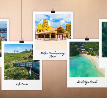
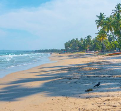
“Love Sri Lanka, Always.” This has been the new campaign of Sri Lanka. Also, this campaign, coming at the time of the ongoing Gulf War, looks quite bold. It projects the island country as a place that needs constant discovery. And Sri Lanka has reaped the benefits of launching a bold campaign. It has crossed the mark of 100,000 tourists within the “first 18 days of the March in 2026.” Furthermore, while the marketing campaign has brought Sri Lankan tourism global visibility, the diversity of attractions makes it a powerhouse. For example, I have been so much in love with Sri Lanka that I have made multiple visits and sometimes to the same place, years apart. With the changes and developments, the country has still maintained its warmth, lush greenery, and human resilience. The sheer grit of the country has helped it win over the natural disasters such as the Tsunami, Cyclone Ditwah, and endless civil wars. However, with diverse offerings, it may be difficult to choose the things to do in Sri Lanka. So, here are the places I loved the most. What Are The Things To Do In Sri Lanka? Keeping the spirit of the Indian Subcontinent alive, Sri Lanka beautifully portrays an inclusive picture. For example, its southern and northern zones show a difference in language and culture. However, both are connected through the way of life, sunshine, and more. Also, Sri Lanka has places such as the Ambuluwawa Tower, which is within a multireligious complex, showing how respectful the country is toward every religion. 1. Exploring The Tamil Culture And Temples In Jaffna Jaffna was the first place I visited in Sri Lanka as a backpacker. It is a hub of strong Tamil culture in Sri Lanka. Furthermore, Jaffna has beautiful Hindu temples such as the Nallur Kandaswamy Kovil, the Naguleswaram Temple, the Nainativu Nagapooshani Amman Temple, etc. Also, the beaches in Jaffna showcase the beauty of Northern Sri Lanka. Moreover, the food in Jaffna is spicier than in any other part of Sri Lanka. Overall, Jaffna is a world in itself where slow living and staying true to the roots are the best ways. 2. Hiking The Ritigala Forest Monastery Out of all my experiences in Sri Lanka, hiking the Ritigala Forest Monastery has been my silent favorite. The history of the Ritigala Forest Monastery takes us to the 1st century BC. It has more than 70 caves and was once the abode of the monks of the “Pansukulika” sect. Furthermore, located inside the Ritigala Forest Reserve, the remains of the ancient monastery are now surrounded by around 96 species of medicinal plants. The presence of the medicinal plants further makes its association with the Ramayana stronger. 3. Visiting Uppuveli Beach, And Other Attractions In Trincomalee Trincomalee has the famous Uppuveli Beach. However, it would be wrong to assume that the things to do in Trincomalee are limited to beach activities. You can visit the Thirukoneswaram Kovil Temple, Fort Frederick, Trincomalee Maritime and Naval History Museum, and the Trincomalee Market. 4. Visiting Mount Lavinia Beach The Mount Lavinia Beach is very close to Colombo, the capital of Sri Lanka. This beach has a leisurely vibe with the local folks playing cricket and people taking a sun bath. However, the main attraction here was the Sea Turtle Conservation Centre. It is located by the beach, and it buys eggs from the locals to hatch them. 5. Climbing Up The Ambuluwawa Tower At the top of the Ambuluwawa Mountain, the Ambuluwawa Tower is an important cultural landmark in Sri Lanka. Its location is in the Ambuluwawa Biodiversity Complex, in Gampola. Also, it is just 20 km away from Kandy. You can climb up its spiral stairs to reach the top of the tower and enjoy a panoramic view of the surroundings. 6. Exploring The Cultural Capital, Kandy Kandy, the cultural capital of Sri Lanka, has the beautiful Kandy Lake at the epicenter. Furthermore, it is fighting with the aftermath of the Cyclone and Ditwah and remains crucial in the political and economic landscape of the country. The most fascinating things to do in Kandy are visiting the Udawattakele Forest Reserve, bowing before the Bahirawakanda Vihara Buddha Statue, and visiting the Temple Of The Tooth. 7. Climbing Up The Sigiriya Rock The Sigiriya Rock is famous for its mythological significance and history, and its association with Buddhism. King Kashyapa made the Sigiriya Rock his seat of power in 477-499 AD. However, before that, it was a Buddhist monastery which later shifted to the Pidurangala Rock. Also, it has a long history of archaeological discovery, and in 1982, it was designated as a UNESCO World Heritage Site. 8. Climbing Up The Pidurangala Rock The Pidurangala Rock has a history that goes back two millennia. After King King Kashyapa made the Sigiriya Rock his seat of power, the Pidurangala Rock became their refuge on the king’s order. Furthermore, it has a 1500-year-old Buddha Statue, and it is a protected ancient cave. Moreover, from the Pidurangala Rock, you will get the best views of the Sigiriya Rock. 9. A Train Ride On The Nine Arch Bridge A train ride on the Nine Arch Bridge is the most iconic experience you can have in Sri Lanka. Also known as the Ella Odyssey, it has been praised by the BBC and Lonely Planet. Built in 1921, this bridge is a prominent example of the Colonia-era architecture, and it does not have any metal in its construction. 10. Hiking To The Diyaluma Waterfall Hiking to the Diyaluma Waterfall from Poongala is one of the most popular hiking expeditions in Sri Lanka. Once you reach the Upper Diyaluma Waterfall, you can relax and enjoy a swim in the infinity pools. From the upper fall, you have to take a further trek of 30 minutes down to reach the Lower Diyaluma Waterfall. Furthermore, the Diyaluma Waterfall is associated with the tragic love story of a King who fell in love with a lady from a lower caste. Knowing about their love, the villagers chased them, and the lady fell into the waterfall and died. 11. Visiting The Dehiwala Zoo Since 1936, the Dehiwala Zoo in Sri Lanka has been a favorite spot for a thrilling wildlife experience. Along with housing monkeys, elephants, fish, and birds, the zoo also has a dedicated section for reptiles. Moreover, it has always been famous for the animal shows, and it has a Leopard Trail for guided night safari. 12. Spending A Day In Hurulu Eco Park The Hurulu Eco Park near Habarana is one of the best places in Sri Lanka to learn the art of slow traveling. In the North Central Province of Sri Lanka, it is a great place for spotting elephants. This dry evergreen is ideal for seeing elephants because it is the corridor between the Kaudulla National Park and the Minneriya National Park. Take an afternoon safari to enjoy wildlife spotting and your time in nature. 13. Visiting Nuwara Eliya, The Coldest Place In Sri Lanka Nuwara Eliya, the coldest place in Sri Lanka, is located at an altitude of 1,889 meters. Furthermore, it carries a nickname, “New England,” from the British Era. Nuwara Eliya is a place of juxtapositions. There are Tudor-style homes, Victorian-style post offices, waterfalls, and jungles, showing the contrast in the landscape and cityscape. Furthermore, it has natural attractions such as Gregory Lake, Victoria Park, and the Lovers Leap Waterfall. Also, don’t forget to spend a day in Horton Plains National Park, a UNESCO World Heritage Site. 14. Experiencing A Scenic Train Ride And More In Ella Though Ella has changed in the last 10 years due to rapid development, it has maintained the serene charm with its mountains, rail line, and lush greenery. Furthermore, it is the place to share a seat with Sir Thomas Lipton and understand how tea runs as the lifeline of the nation. Also, the Ravana Falls is the place where Ravana hid Sita after abducting her. Other iconic things to do in Ella are visiting the Nine-Arch Bridge, enjoying a Kandy to Ella train ride, climbing the Ella Rock, watching sunset from the top of the Little Adam’s Peak, etc. 15. Exploring The Galle Fort Galle is dreamy, and it looks like a movie frame in sepia tone. However, the Galle Fort, a UNESCO World Heritage Site, is at the epicenter of this once impenetrable trading post. Walk to the Galle Fort and explore this living museum of art, architecture, and history. Also, watching the sunset from the Galle Fort is a magical experience. More things to do in Galle include exploring the beaches beyond the fortress wall. Also, don’t forget to enjoy a drink in a bar in the cobblestone streets of Galle. Overall, Galle is a place that unfolds with time. The fortress, the streets, and the colonial buildings make history palpable in every nook of Galle. In a way, it summarizes the true spirit of Sri Lanka. Visiting the country is not about ticking the bucket-list destinations. It’s about understanding the culture and soaking in the local vibe. 16. Visiting The Hiriketiya Beach Hiriketiya Beach is the latest addition to the tourism attractions in Sri Lanka. It is a favorite destination for backpackers and digital nomads. Furthermore, it is a popular surfing beach with zones dedicated to surfers of different expertise levels. Here, you can walk to the Blue Island, enjoy great food and beer at Smoke and Bitters, and learn how to cook with Rosie.
What Are The Things To Do In Galle Fort, Sri Lanka? Exploring A UNESCO Heritage Site
BY Sibashree Mar 24, 2026
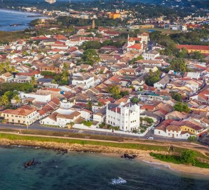
Galle has been my ideal dreamy, sepia-toned travel destination located on the southwestern coast of Sri Lanka. Moreover, the city’s stunningly beautiful old fortified peninsula reaches defiantly out into the Indian Ocean and boasts many crumbling colonial-style buildings, narrow cobblestone streets, and swaying palm trees. However, the true magic of Galle comes from taking it slowly. Hi, in today’s blog, I will talk about the things to do in Galle Fort. However, I will begin with why a visit to the Galle Fort is worth it and how to get there. Why Visit Galle Fort? A UNESCO World Heritage Site And The Fortress That Defied Time “Founded in the 16th century by the Portuguese, Galle reached the height of its development in the 18th century, before the arrival of the British. It is the best example of a fortified city built by Europeans in South and South-East Asia, showing the interaction between European architectural styles and South Asian traditions.” • UNESCO World Heritage Convention. The trading post was once impenetrable, and the rampart walls kept the invaders at bay. However, centuries later, during the 2004 Tsunami, the same stone walls that stood against cannons also protected the people from the ocean. Thus, the Galle Fort remained intact even though the surrounding coastline was devastated. Today, it stands as a UNESCO World Heritage Site for being a unique example of a fortified city. How To Reach The Galle Fort? You can easily reach the Galle Fort from Colombo or down the coast. From Colombo You can take a train from Colombo Fort, and after a three-hour journey and amazing ocean views, you will reach Galle. However, currently, this route is being reconstructed. So, you can take a Highway AC bus from the Makumbura Station. Furthermore, it is a 2-hour journey through the Expressway. From Mirissa Or Weligama If you’re already beach-hopping the south coast, you can just hop on any local bus headed toward Matara or Galle. It’s cheap, frequent, and gives you a real taste of local life, and that’s amazing as a follower of TheLowDownUnder Travel philosophy. Also, from my days in Jaffna to the things to do in Kandy, I have always ditched comfort and the obvious for a more authentic experience. What Are The Things To Do In Galle Fort, Sri Lanka? When talking about the things to do in Galle Fort, you have to think beyond the tourist checklist. Furthermore, Galle is a place of contrasts! You have the rugged, salt-sprayed stone of the ramparts on one hand, and on the other hand, you have the most polished boutique shops. So, Galle is beyond your usual Instagram photo op. And one of the best things to do in Galle is to understand how the fortress and the neighborhood have survived empires and natural disasters. Moreover, in Galle, you become a part of the history as you watch the sunset from an ancient bastion or sip cold beer at a wine bar on a cobblestone street. Also, you will see an extension of all these in my detailed account of two days in Galle Fort. Day 1: Getting Lost In The Living Museum Walks, exploring the architecture, culture, and the much hyped sunset experience! These were the things to do in Galle Fort on day one. Morning: The Rampart Walk Walking is the best way to begin your exploration of Galle Fort. It is small and, therefore, a great destination for pedestrians. In the morning, I climbed to the top of the stone ramparts and walked the entire way around the edge of the Fort, obtaining a 360-degree view of Galle. I saw the sparkling, turquoise ocean to one side and the red tiled roofs of the original buildings of the town on the other. On your walking tour, look for the famous Galle Clock Tower and the historic Galle Lighthouse, which is probably the most photographed place in all of Sri Lanka. The whitewashed lighthouse is stunning against the clear blue sky, but I found that the late afternoon light gives it that soft, golden color that makes the palm tree shadows cast perfectly across the grass. Afternoon: Culture And Architecture After you’ve finished exploring the upper level of the walls, it’s time to explore the narrow alleyways of the city. Throughout the streets, you are going to notice something extremely wonderful. You will see the cultural and ethnic diversity and the same inclusive culture of Sri Lanka, prominent through the iconic Ambuluwawa Tower in Colombo. In just a matter of blocks, I was able to visit the Dutch Reform Church, All Saints Anglican Church, Meeran Mosque, and Sri Sudharmalaya Buddhist Temple. All these places serve as a testament to the many different people who have influenced the development of Sri Lanka over many hundreds of years. If the heat of the sun becomes unbearable, I recommend that you check out either the Historical Mansion Museum or the Maritime Museum. Both of these museums are in beautifully restored colonial structures and provide visitors with great artifacts dating back to Sri Lanka’s colonial period. Evening: The Sunset Ritual When the sun is going down, I suggest that you make your way to the western walls of the fort. At Flag Rock Bastion, you will find the locals performing their “cliff jumping” tourism attraction. You will have the opportunity to see how far they will go into the crashing waves. If you would rather have a quieter spot to watch the sunset, I would recommend that you go to Triton Bastion. I spent an hour there on the grassy ramparts watching as the sky slowly burned with bright oranges. What a way to see Mother Nature's fireworks show. Day 2: Boutiques, Buffets, And Beaches Day 2 was more relaxed as I shopped, gorged on grand feasts, and explored the beaches. Morning: The Shopping Mecca Galle is now Sri Lanka's shopping capital. Pedlar Street is the epicenter of the boutique shops, from where you can collect elegant souvenirs. A few of my personal favorites are in the table below. Places to Visit for ShoppingThings to BuyStick No BillsVintage-Style PostersThe Tea Room by Evergreen GroupBuy Tea in BulkOld Dutch HospitalThis former colonial hospital is now a chic shopping and dining precinct. It’s the perfect place to grab a coffee and browse. Lunch: A Local Feast After the spicy food in Jaffna, the food in Gelle was comforting. So, trying the Coconut Sambal is one of the best things to do in Galle. You will get the curries with chicken and vegan-friendly options here. Also, to beat the midday Sun, have some homemade ginger beer or treat yourself to a scoop at Isle of Gelato. Moreover, don’t forget to try the cashew caramel at Isle of Gelato. Afternoon: Beyond The Walls As the Sun starts getting softer, you can explore the surrounding coast. Also, if you want to extend your coastal hunt, head to Dewata Beach. Here, you will find many beginners and professionals surfing the waves. Furthermore, if you want to just relax, take a tuk-tuk ride to the Jungle Beach in Unawatuna. It is a small sandy cove with lush greenery.

What Are The Things To Do In Ella, Sri Lanka? A Narrative Of My Days In Ella
BY Sibashree Mar 24, 2026
Ella is one of Sri Lanka's most beautiful towns. Also, Ella is a place where many of my favorite Sri Lankan adventures are. My first sighting of the famous Nine Arch Bridge, one of my first hikes at Ella Rock, standing at the edge of the roaring Diyaluma Falls, and many more. Perhaps the most famous train ride in the world, from Kandy, passes through Ella as well. Ella is a quaint and beautiful town and is a great place to escape the heat of the southern coasts. However, over the last decade, this quaint little hamlet has become a large tourist destination. Unfortunately, the growth has also brought some concrete eyesores to the village. There is still plenty of magic to be discovered here, if you are willing to move beyond the Instagram hotspots. Having undertaken two comprehensive visits to this beautiful hill-country retreat, I have compiled the ultimate portfolio of things to do in Ella, Sri Lanka. What Are The Things To Do In Ella, Sri Lanka? Despite the changes in Ella, Sri Lanka, the mountain ranges are just as majestic as they were years ago. Furthermore, the tea served is still some of the finest in the world. Moreover, people here are still warm. And the most fascinating part? Ella always brings out the explorer in you. How can you avoid the lure of riding in an open-air train or leaning over the edge of a waterfall? Here is more about the exciting things to do in Ella, Sri Lanka. 1. Riding The Iconic Kandy To Ella Train The Kandy to Ella train ride is the best thing you will do in Sri Lanka. The train passes through tea plantations and crosses gushing streams. And you cannot expect less from a route that has been labelled by many as the most picturesque train ride in the world. However, the train ride also allows you to indulge in the local vibe with local vendors hawking through the rush and the local boys singing and playing drums during the journey. Also, the Nanu Oya to Ella scratch is the most beautiful in the entire route. Also, don’t go for a 1st class ticket and reserve a 3rd class class to enjoy the views through open windows. 2. Admiring The Famous Nine Arch Bridge It’s astonishing to think that a single bridge could drive tourists in droves to a small town, but the Nine Arch Bridge is an engineering marvel that demands to be seen. Standing 24 meters high and spanning 91 meters, it was completed in 1921 using only brick, rock, and cement, and there is no metal at all. When the mist hangs low in the valley, the bridge takes on a moody, mystical feel. You can walk along the tracks or look down from the tea plantations below, but my favorite view is from the cafe platforms in the surrounding hills. Watching the blue train slowly crawl across the arches is a sight I’ll never forget. 3. Hiking The Mighty Ella Rock The hike to the mighty Ella Rock starts from the Ella railway station. It was a walk with waterfalls and small homes on the way. Then, the steep ascent began. After reaching the top, you will get a beautiful view of Adam’s Peak and Ella Gap. 4. Watching Sunset At Little Adam’s Peak The hike to Little Adam’s Peak is a gentler alternative to the hike to Ella Rock. I walked through the lush tree plantations, and once I reached the top, the panoramic view before my eyes was nothing short of a movie frame. Plan your hike in the late afternoon to enjoy the most amazing sunset views from Little Adam’s Peak. 5. Chasing The Diyaluma Falls I started from Ella to Poonagala, the starting point for the Diyaluma Falls hike, by taking a tuk-tuk. The tuk-tuk took 1.5 hours. Furthermore, from Poonagala, it was a downhill hike to the Upper Diyaluma Falls, which had a 220-meter drop. There are natural infinity pools right at the edge where you can swim during the dry season. From the upper Diyaluma Falls, it is another 30-minute hike to the Lower Diyaluma Falls. 6. Feeling The Mythological Connection At Ravana Falls Ravana Falls is right by the road south of Ella. Locals say that King Ravana took Princess Sita and hid her in the caves behind Ravana Falls. Furthermore, you can see the Ravana Falls from the road. However, it is best if you hike to the second and third tiers. 7. Taking A Seat With Sir Thomas Lipton Tea is the lifeblood of this region, and a visit to Lipton’s Seat is a journey to the source. This is the exact spot where tea mogul Sir Thomas Lipton used to sit and survey his empire. On a clear day, you can see all the way to the south coast. Even on the foggy day I visited, sipping a fresh cup of Ceylon tea (the best I’ve ever had) while the clouds swirled around the summit was incredibly atmospheric. 8. Taking A Tour Of The Dambethenne Tea Factory When you go to the high country, you must learn the actual science of the making of your brew. I visited the tea company founded by Lipton himself in 1890 and saw how it was picked, wilted, fermented, and graded. All of these were new to me as an individual who drinks a lot of tea. About 80% of this tea is sold in Colombo and then exported around the world. I especially found the fermenting room to be extremely interesting. 9. Feel The Adrenaline Rush At Flying Ravana If you need a break from the hiking, Ella recently opened Sri Lanka’s first-ever zip-line. It stretches half a kilometer across the hills and hits speeds of 80kmph. For around $20 USD, it’s one of the best value adrenaline fixes I’ve ever found. It’s located near the 98 Acres resort, making it a perfect way to end a trip to Little Adam’s Peak. 10. Mastering The Art Of The Curry At Ella, Sri Lanka In my opinion, Sri Lanka has the best food (after my country, of course)! If you want to bring back a little bit of Sri Lanka to your home country, then you should try taking a cooking class. Also, if you don’t have enough time, just try the food streets. For me, it was a brilliant consolidation of my food tour in Jaffna. Though the food in Ella is creamier and less spicy than in Jaffna. 11. Witnessing The Grandeur Of Bambarakanda Falls The Bambarakanda Falls is the tallest waterfall in the country, and it falls from a height of 241 meters. You can take a short hike or a tuk-tuk to reach the Bambarakanda Falls from Ella. Then, stand at the base and feel the sheer power of that vertical drop. Moreover, to enjoy the best flow of this waterfall, plan a visit between April and September. 12. Spotting The Elephants At Udawalawe Like the Kaudulla National Park, the Udawalawe National Park is also a great place for spotting elephants in the wild. Ella is the base for a safari in the Udawalawe National Park. I opted for an early morning safari, and I spotted adorable baby elephants with their mothers. Don’t Forget To Party And Chill In Ella, Sri Lanka Like Jaffna, a backpacker’s dream, Ella has also emerged as a hub for backpackers and budget travelers. Ella Town is still a great place to unwind, and places such as Cafe Chill are at the epicenter of these scenes. You can have some really good burgers and Lion Beer at some of these recognized cafes. Moreover, when you spend time at these cafes, you don’t rush from one place to another, but study the local culture and understand how a country, ridden by cyclones, endless civil wars, and financial crisis, can still be the land of sunshine.

What Are The Things To Do In Nuwara Eliya? Know Why It Is Worth Visiting
BY Sibashree Mar 24, 2026
The train departed the moist jungle and slowly had a rhythmic ascent to the central highlands. The visual completely changed, and there was a complete change in the air. It went from high humidity tropical to cold, fresh pine scent breezes. The jungle changed as well, from lush jungle trees to neat rows of green tea bushes. And, finally, I arrived at Nuwara Eliya, a small city at an altitude of 1,889 meters. It is also called "Little England,” a term left over from the time of the British. It is a surreal combination of red-brick Victorian post offices and Tudor-style homes. Furthermore, it has a setting for the extremes of dramatic waterfalls and successive mountain peaks. This misty highland getaway should not be left out of your Sri Lanka travels, whether you are into the history of buildings, enjoy areas with natural beauty, or have an appreciation for tea. Overall, there are diverse things to do in Nuwara Eliya. Also, if you are visiting from India, you can opt for the IRCTC package in association with the Sri Lankan Airlines, to visit Nuwara Eliya with Negombo, Kandy, and Colombo. You can even explore the things to do in Trincomalee on this trip. Moreover, you can combine your Nuwara Eliya trip with a visit to the Ambuluwawa Tower. What Are The Things To Do In Nuwara Eliya? A Town Of Two Worlds Nuwara Eliya reminds you of the rich history and diversity of Sri Lanka. You can relax with a round of golf on one of the golf courses in Asia. Furthermore, as the Sun sets, you can stand on the top of a cliff and enjoy the views of the mountains. The lifestyle and culture here are so different from the lower elevation regions. 1. Exploring The Architectural Heritage: Looking Back At Time Nuwara Eliya's connection to Britain is more than mere embellishment, but rather its essence. The downtown area of Nuwara Eliya resembles a small village in the Cotswolds, but with tropical vegetation growing nearby. The Nuwara Eliya Post Office The Nuwara Eliya post office is one of the most photographed buildings in Sri Lanka. Built in 1894, this pink-brick Victorian structure is still in use today and is located at the centre of Nuwara Eliya city. The post office is traditionally a popular choice for tourists to purchase a postcard (with a scenic image of the misty hills) and send it back home with the Nuwara Eliya postmark on it. The Grand Hotel And Hill Club To get a real feel for how the elite lived during the time when colonialism was at its height, you will want to check out The Grand Hotel. The Grand Hotel was formerly owned by Sir Edward Barnes, who was the Governor of Ceylon. The Grand Hotel is noted for its High Tea service. High Tea is served on the beautifully manicured lawn or in the lavish tea lounge and consists of 2-tiered stands of cucumber sandwiches, scones with clotted cream, and, of course, the best Ceylon tea. Located next door to The Grand Hotel is The Hill Club, which has a strict jacket-and-tie dress code and is an example of traditional old-world decorum. 2. Enjoying The Tea Experience: From Buds To Cup Aspects like climate and altitude make Nuwara Eliya an ideal place to grow tea and give its tea a unique and delicate floral flavor. This high-grown tea is referred to as the "Champagne of Ceylon Tea" due to its light golden appearance. Pedro Tea Estate Located a little bit from the city center, this estate has one of the most manual factory tour processes. It is so delicate that the processing has to happen at night, and that is when the air is cooler. During the tour, you get to see 19th-century machinery that is still used to wither, roll, and dry the leaves. When you are done with your tour, you get to sit at the outdoor deck of the Lovers Leap Ethical Tea Boutique, sip a fresh brew, and watch the fields from which the leaves were plucked. Damro Labookellie Tea Centre It is the largest tea Centre in the country and is also one of the oldest. The journey to the estate is an experience in itself. It features a multitude of hills and tea. 3. Natural Wonders: Parks And Waterfalls Nuwara Eliya has abundant water and lush greenery. The combination of high elevation and significant rainfall results in an environment that stands out distinctly from the rest of the island. Victoria Park This park, named to commemorate Queen Victoria’s Diamond Jubilee, is arguably the most well-preserved park in South Asia. It serves as a haven for bird enthusiasts seeking to spot rare species such as the Indian Blue Robin and the Pied Thrush. During the spring months (March to May), the park bursts forth with vibrant colors as roses and dahlias reach their peak bloom. Gregory Lake Initially constructed to produce electricity for the town, Gregory Lake has transformed into the city's main recreational area. Visitors can rent swan-shaped pedal boats, go jet skiing, or enjoy a pony ride along the shoreline. The pathway along the lake has small chalets offering street food, making it an ideal location for a late-afternoon walk as the mist gently settles over the water. Lovers Leap Waterfall Accessible via a short hike through the tea estates, Lovers Leap is a 30-meter waterfall with a tragic legend. Folklore tells of a royal prince and his lover who leapt from the top to remain together forever. Today, it provides a serene escape and a panoramic view of the town below. 4. Enjoy The High-Altitude Adventure: Horton Plains No visit to Nuwara Eliya is truly complete without spending a day at Horton Plains National Park. This UNESCO World Heritage site is a tranquil, windswept plateau situated roughly an hour's drive from the city. World’s End The highlight of the 9-kilometer circuit hike within the park is World’s End, where the plateau suddenly drops off, plunging nearly 880 meters straight down. On a clear day, the breathtaking view stretches all the way to the southern coastline. Pro Tip: It's essential to reach the park entrance by 6:00 AM. By 9:30 AM, a thick "curtain of mist" typically descends and obscures the scenery. Baker’s Falls During the same hiking loop, you'll come across Baker’s Falls, named after the renowned explorer Sir Samuel Baker. This waterfall has unique ferns and rhododendrons around, providing a refreshing, misty break amid your trek. 5. Local Flavors And Markets Although the hotels serve sophisticated British cuisine, the heart of Nuwara Eliya’s food culture lies within its markets. The Bale Bazaar Locally referred to as the "Winter Market," this spot is ideal for finding quality cold-weather clothing, such as jackets, sweaters, and scarves, at affordable prices. Given the significantly cooler climate compared to the rest of Sri Lanka, the market is essential for both locals and tourists who may not be prepared for the chill. Adma Agro Strawberry Farm Nuwara Eliya stands out as the only region in Sri Lanka that successfully cultivates strawberries. At Adma Agro, visitors can indulge in fresh strawberries with cream, strawberry pancakes, or thick milkshakes while enjoying a view of the greenhouse rows. This experience is a defining treat of Nuwara Eliya. Remember These Practical Tips Before Trying The Things To Do In Nuwara Eliya The ideal time to go is between February and April. The city is especially vibrant in April as it celebrates the Sinhalese and Tamil New Year. During this month, the city features horse races, flower exhibitions, and car races. Just be ready for larger crowds and increased prices during this peak season. Furthermore, Nuwara Eliya is the coldest place in Sri Lanka, and the nighttime temperatures can drop to 10°C. So, bring a jacket. Also, most budget accommodations lack central heating, so having a warm fleece and sturdy walking shoes is crucial for navigating the hills. Moreover, the train trip from Kandy to Nanu Oya (the station for Nuwara Eliya) is one of the most beautiful in the world. From Nanu Oya, it’s just a quick 15-minute tuk-tuk or bus ride to reach the city center.
Where Is Uppuveli Beach, Trincomalee? What Are The Best Things About The Beach?
BY Sibashree Mar 24, 2026
After spending time in the northern city of Jaffna exploring everything it has to offer, I was looking forward to relaxing. Jaffna has some beautiful temples, and despite being a slow travel destination, the rich Tamil culture and history offered a fulfilling experience. However, I needed a place where I could relax and soak in the memories I have collected there. I intended to enjoy just those "beachy" times when I arrived at Trincomalee, and that is exactly what I found on the Uppuveli Beach. This was the ultimate "holiday within my backpacking trip," and completely different from the beaches in Jaffna. Where Is The Uppuveli Beach? Uppuveli Beach is in Trincomalee. On the northeastern coast of Sri Lanka, it is further the epicenter if you are exploring the things to do in Trincomalee. The distance between the Uppuveli Beach and the Trincomalee city center is just 6 kilometers. So, you can reach within a drive of just 15 minutes. Moreover, it is famous for the beauty of the Bay of Bengal, and from here you can explore nearby attractions such as the Pigeon Island Marine National Park and Swami Rock. How To Reach Uppuveli Beach From Trincomalee? The Blue Bus Experience? You can travel from Jaffna to Trincomalee by bus like me. Trincomalee, anyway, is a major transport hub. Furthermore, it is well-connected to Colombo, Kandy, and even Habarana, which is the major gateway to many other things to see in Sri Lanka, such as the Hurulu Eco Park, Sigiriya Rock, the Pidurangala Rock, and the Kaudulla National Park. I reached Trincomalee from Jaffna by bus within 4 hours and 50 minutes. However, our driver, Ahoy, said that on days of dense traffic, it can take up to 5 hours and 30 minutes. Travel From Jaffna To Trincomalee By Bus The blue buses from Jaffna to Trincomalee are the cheapest mode of transport. The ticket cost roughly 1100 LKR. From Trincomalee To Uppuveli Beach From the Trincomalee Bus Station, I took a tuk-tuk to the Uppuveli Beach. The tuk-tuk driver charged me 500 LKR. The Experience At Uppuveli Beach Uppuveli Beach is the place that offers you simplicity, and here, you will forget keeping track of your time. You can swim, sunbathe, or just soak in the beauty of the golden hour, or just soak in the beauty of golden hour or count the waves like me. The Golden Hour See a sunset on the beach while it’s still dark out. Uppuveli faces the east, and it offers an amazing view of the Bay of Bengal when the sun rises. The sky looks like it’s on fire with shades of pink and gold lighting up the clouds. The Waves The waves were huge when I was there in July. The waves here rise really high above your head and can definitely knock you over if you don’t pay attention to them when swimming. If you can catch the waves just right, they are also great for body surfing. As always, be respectful of the Indian Ocean. What Are The Things To Do At Uppuveli Beach? Uppuveli offers a serene alternative to the more crowded southern beaches. Boasting breathtaking turquoise waters and palm trees swaying in harmony with one another, Uppuveli is a welcoming community that exudes a sense of calm. 1. Marine Adventures At Pigeon Island Marine National Park The number one attraction in Uppuveli is Pigeon Island Marine National Park. A 20-minute boat ride from the beach will take you to Pigeon Island, a protected sanctuary surrounded by colorful and lively coral reefs. Pigeon Island is famous as one of the three places in the world where you can see black-tip reef sharks and giant sea turtles in the shallow waters (up to 12 feet). You may also dive deeper by visiting several local dive shops that operate daily excursions to the Uppuveli Pinnacles and the famous shipwrecks in and around Uppuveli. Local dive shops also provide excursions between March and September to boat watch for blue whales and pods of spinning dolphins. 2. Visit The Cultural Landmarks Of Swami Rock You may take a short tuk-tuk ride to the Swami Rock Temple located in Trincomalee town. Swami Rock is perched on a cliff and provides some of the best views of the ocean as you look towards the Koneswaram Hindu Temple, which is located in the middle of the cliff and overlooks Trincomalee Harbor. The temple is dedicated to Shiva and is a great example of intricate Dravidian-style architecture. In addition to the temple at Swami Rock, you will also see Lover’s Leap, which is nearby and steeped in local folklore. 3. Visit Fort Frederick And Find Spotted Deer On your way to the Koneswaram Temple, be sure to visit Fort Frederick. It is a 17th-century fortress built by the Portuguese. Fort Frederick today is a peaceful area. It has many spotted deer, and you can see them roaming freely between colonial buildings and massive banyan trees. 4. Kanniya Hot Water Springs For something unique, head inland to the Kanniya Hot Water Springs. There are seven stone wells here, each producing water at a slightly different temperature. It’s a traditional site for ritual bathing. Also, people believe that water here has healing properties. Moreover, at Uppuveli Beach, you can have the best dining and drinking experience thanks to places such as Fernando’s Bar, Rice 'n' Curry, and Cafe on the 18th. Also, you will find Wanderers Hostel and other budget-friendly places to stay near the Uppuveli Beach. When Is The Best Time To Visit Uppuveli Beach? The best time to visit Uppuveli Beach is between February and August, and July is the peak month. From August, the ocean starts getting a little rougher. Moreover, as I have mentioned, it is best to hit the beach when it is still dark. Thus, you can enjoy the magic of the sunrise. Also, if you want a drink by the sea, 3:30 PM to 4 PM will be the best. As you gulp down some cold Lion Lager, the Sun prepares to go to rest for the day.
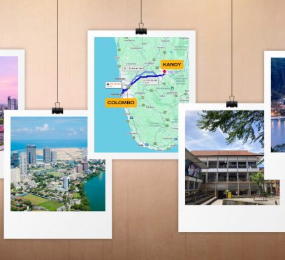
What Is The Colombo To Kandy Distance? Know How To Travel By Car, Bus, Tuk-Tuk And Train
BY Sibashree Mar 24, 2026
Ancient Temples! Colonial Architecture! The Serene Kandy Lake! Beautiful Gardens! And, the Bustling Crowd! All these and more things to do in Kandy make it the cultural and historical capital of Sri Lanka. And this time, it’s about the Colombo to Kandy distance. It is now more important to know about the modes of travel because Cyclone Ditwah has devastated the Sri Lankan railway infrastructure, including the Colombo to Kandy route. So, explore the options. What Is The Colombo To Kandy Distance? The distance between Colombo and Kandy is around 121 km. The travel time by road through the Kandy Road is around 3 hours and 30 minutes. However, the travel time will depend on the mode of transport you choose. So, here is a quick summary. Modes of Transfer from Colombo to KandyTravel Time By Car3 Hours and 30 MinutesBy Train2.5 to 3.5 HoursBy BusAbout 4 Hours Furthermore, from Kandy, you can enjoy the most scenic train ride on the Colombo-Kandy-Ella-Badulla railway through the Nine-Arch Bridge. Also, Kandy is well-connected to Habarana by train. And Habarana is the gateway to cultural attractions such as the Sigiriya Rock and Ritigala Forest Monastery. You can even go on a wildlife safari from Kandy to the Kaudulla National Park. How To Travel From Colombo To Kandy? You can travel from Colombo to Kandy by bus, private transfer, or train. Here are the details. 1. How To Travel From Colombo To Candy By Train? Unfortunately, the Colombo to Kandy train route is still under renovation. So, if you are traveling to Sri Lanka anytime soon, you will not be able to take the train service. However, according to a report published on Adaderana.lk, a leading 24x7 news portal of Sri Lanka, the train service on this route will resume within 1 year. In this report dated 11th January, 2026, Prasanna Gunasena, the Deputy Minister of Transport and Highways, has further confirmed that the authority is taking every possible measure to restore the services. 2. What Is The Colombo To Kandy Bus Service? The Colombo to Kandy bus service operates from the Colombo Bastian Mawatha Bus Terminal to the Kandy Good Shed Bus Station. Bus services are available every 30 minutes, and the travel time by these buses is around 4 hours. Furthermore, the ticket for the public bus services from Colombo to Kandy costs about 157 LKR, and the tickets for the AC buses can cost close to 3000 LKR. Also, the public bus service from Colombo to Kandy (Route No: 1) starts from 3:30 AM and the last bus departs at 11 PM. 3. Private Transfers From Colombo To Kandy Starting from my days in Jaffna to now, this Colombo to Kandy journey, I have always opted for budget-friendly modes of transport in Sri Lanka. However, if budget is not a constraint for you, you can choose a private transfer from the Sri Lankan capital to the cultural epicenter. The private rental for this route will cost you around 9000-13000 LKR, and you will also find many online options. Moreover, if you want the safest option to travel between Colombo and Kandy by road, you can opt for the Uber service. Yes, it is expensive as the services start from around 48000 LKR, and it is the price for the Uber Go Intercity rentals. The Uber Sedan Intercity and the UberXL Intercity services cost even more. What Is The Best Time For A Colombo To Kandy Trip? Kandy’s central location in Sri Lanka’s highlands gives it a cooler and wetter climate compared to the surrounding lowland coasts. Plan your trip to Kandy during the right time of the year to get the most out of your visit. The Best Time To Visit The best time to visit Kandy is between the months of January and April due to the warm temperature and low humidity. This time frame has the least amount of rain, which is essential for planning out sightseeing activities. The Monsoons The climate of this region is heavily influenced by the monsoon seasons. The unpredictable weather can be a challenge during the months of May to July and October to December. A visit in November has the advantage of having fewer tourists compared to other months; however, consistent rain can make visiting outdoor attractions difficult. Important Travel Advice Kandy is extremely busy during the Sinhalese New Year, which occurs twice a year in April. Avoid traveling during this week as all public and road travel will be extremely congested due to the celebratory travel of the locals. This will create a frustrating and overwhelming spike in logistical travel obstacles. What Are The Places To Visit On The Route From Colombo To Kandy? The drive from Colombo to Kandy takes you on an enjoyable journey through beautiful scenery as you travel uphill from a busy, urban environment to the lush tea plantations and mountain peaks shrouded with mist. If you plan to take this trip, there are many places where you will want to stop so that you can appreciate what is known as the "Gateway to the Hill Country." 1. The Pinnawala Elephant Orphanage The Pinnawala Elephant Orphanage is one of the best-known detention centers for orphaned elephants in the world and has been established for many years. Now that you know the date, I recommend arriving at least 30 minutes before the start of your visit so that you can watch the elephants walk from the orphanage to the Maha Oya River to have their daily bath. 2. The Ambuluwawa Tower The Ambuluwawa Tower is a great location for Wright Brothers-style views of the area. It is located within a short distance of Gampola. It is at a multi-religious complex, and this unique white spiral structure offers an exciting, narrow ascent with amazing 360-degree views of the entire central highlands. 3. The Kadugannawa Rock Tunnel It is a tunnel chiseled from the rock on your way towards Kandy, and also has a legend that British soldiers cut this tunnel so that they could fulfill a prophecy. The prophecy said that "Those who pierced the mountains will be the ones who take Kandy." 4. The Bible Rock Bible Rock is a flat-topped mountain that is shaped like an open book. You can spot it at the Kadugannewa Pass. Dawson Tower stands atop the pass; this is a white column built to commemorate the British Engineer who created the road.
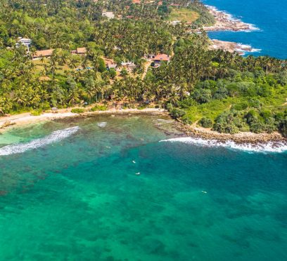
Hiriketiya Beach, Sri Lanka: Location, How To Reach, Things To Do And More
BY Sibashree Mar 23, 2026
Hiriketiya Beach is a place that can disrupt your travel plans completely. You may arrive with plans for a two-night stay and end up spending 3 weeks developing a routine of mornings spent surfing, drinking coconut coffee, and watching the sun set down on the jungle. This tucked-away cove in Sri Lanka’s southern coast, nicknamed by its community of surfers and digital nomads as "Hiri", is a textbook example of tropical aesthetics. The cove is well-formed, with water that is surrounded by palm trees, and has a jungle so dense behind it that you will hear monkeys scurrying through the tree tops of your surfboard as they find their way there. Hiri feels like a secret to be shared, but is just being revealed to people in the surrounding towns of Weligama and Mirissa. Hiriketiya has developed to become a more sophisticated version of Weligama and Mirissa. The "vibe" of Hiriketiya is not just another phrase used by hipsters. It is the currency used by locals. Here is more about this beautiful coastal gem in Sri Lanka. The Evolution Of Hiriketiya Beach: Why You Need To Go Now Hiriketiya has experienced an incredible transformation over the last few years. Only a few years ago, this sleepy little fishing village had only a few guesthouses and one small roti shop. It is quite similar to the beaches in Jaffna in that way. Now, it's become a vibrant hub, and even though it has lost some of its "untouched" charm. Moreover, this infusion of new energy has produced world-class specialty coffee shops, beautiful state-of-the-art Yoga studios, and a co-working scene. But despite these rapid changes, the spirit of this village remains. The Surf At Hirikeya Beach: A Wave For Every Soul The horseshoe shape and the unique geography of the Hirikeya Beach make it ideal for every type of surfer. Here is a quick breakdown. Surf LocationDetails The Beach Break (Right Side)- Beginner-Friendly- Sandy Bottom- Gentle WavesThe Middle- Ideal for Longboarders- Offers a Mellow RideThe Point Break (Left Side)- Ideal for Professionals- Shallow Reef Board rentals are standardized at 1000 LKR per hour. If the Hirikeya Beach is very busy, you can go 3.5 km east and find Kudawella Beach. Where Is Hirikeya Beach? How To Reach It? Hiriketiya is located off the main highway along the coast, about one mile away from the town of Dickwella. Since Hiriketiya is not on a major transit route, you will have to use Dickwella as your transit point. 1. Traveling To Hiriketiya Beach From Colombo The best way to get there is by taking the train from Colombo Fort to Matara, which takes approximately four hours. From Matara, you can take a local bus to Dickwella or take a tuk-tuk taxi. You can also take a highway express bus from Colombo to Matara and arrive in about three hours. 2. Traveling To Hiriketiya Beach From Ella You can catch the #31 bus at the intersection of the Ella-Passara Road as you travel through tea country. It is approximately four hours to the coast on a winding road. Just tell the conductor you want to go to Dickwella. 3. Traveling To Hiriketiya Beach From Arugam Bay If you are traveling from the East Coast surf to the surf in the South, there is a direct bus leaving from Pottuvil every day around 6:30 AM, arriving at Dickwella approximately six hours later. What Are The Things To Do At Hirikeya Beach? (Beyond Surfing) Hiri has just as much gravitational force to attract chill seekers. So, here are the things to do beyond surfing. 1. Walk To Blue Beach Island If you're looking for a little adventure, try the 2.5km (1.5-mile) walk to Nilwella. You'll be walking through peaceful local neighborhoods when you find a beautiful natural sandbar that links the mainland with a small island. Moreover, walking over a sandbar with breaking waves on both sides of you is something you will remember long after leaving Hiri. Also, it is the best place to watch the sunset. 2. Sip In Style At Smoke And Bitters Believe it or not, one of the 50 Best Bars in Asia is hidden deep in a coconut grove. Furthermore, the menu at Smoke and Bitters is based on the smokehouse method of cooking, using local Sri Lankan ingredients with cooking methods from around the globe. Moreover, you must try the smoked harissa pumpkin and the pork ribs as they are WOW!! Every cocktail created at Smoke and Bitters is a work of art. The price of a drink here, compared to what you would expect to pay in Sri Lanka, may seem high. However, when you want to treat yourself, there is no better place to go. 3. Become A Culinary Master With Rosie Rosie's cooking class experience is the ultimate rite of passage in Hiri. While she prepares the dishes during your cooking class, you will also hear many personal stories of her life and how she made some special Sri Lankan spice combinations. Moreover, it costs 6000 LKR, and the 4-hour feast is the ultimate attraction. The Digital Nomad And Yoga Scene At Hirikeya Beach Hiriketiya has become a cornerstone of the "work-from-anywhere" lifestyle. Places like Dots Bay House and Salty Pelican provide the infrastructure (and the caffeine) needed to hit deadlines. Moreover, when it comes to physical and mental well-being, Arise is unparalleled. So, they provide a variety of classes to choose from, including Muay Thai, ecstatic dance, and Reiki, as well as many types of Vinyasa yoga. Additionally, their Salt House location offers stunning rooftop yoga classes where you can do yoga while listening to the waves below. Where to Stay In Hiriketiya? Hiriketiya offers a versatile range of accommodation. Here are some places you can try. 1. Salt House This upscale beach hotel has a boutique feel. Located 5 minutes away from the beach, the hotel has spacious, minimalistic rooms opening directly to its central pool and open-air cafe. Moreover, on-site yoga classes every day attract those interested in wellness. Room rates begin at about 21000 LKD per night. 2. Dots Bay House Located next to the surfing area, 'Dots', the centre of Hiri's social scene, offers accommodation options ranging from dormitories to high-end private rooms. Moreover, facilities include an on-site co-working space, swimming pool, and popular bar which features the best live music acts in town. Prices start at approximately 7000 LKD per night. 3. Hiriketiya White House A charming, family-owned guesthouse hidden away in the jungle, offering an excellent option for visitors who want authentic experiences at affordable prices. Also, the double rooms come with beautiful contemporary bathrooms and balconies where guests can enjoy watching monkeys play overhead. Moreover, the prices start from about 5500 LKD per night. When To Visit Hiriketiya Beach? Due to offshore winds and consistent swell during the "High Season", November to April is the best time for surfers to be out on the ocean. Moreover, December to February is the busiest time of year, with hot and dry weather as well as a lot of activity happening around town. However, there are two downsides. The first is that accommodation prices rise significantly, and the second is that line-ups at the ocean can be extremely crowded. Where To Eat In Hiriketiya? As an enthusiast of TheLowDownUnder Travel and genuine experiences, I felt compelled to sample the local cuisine at Hirikeya. So, here are a few recommendations for places to check out. 1. Lemon Grass Café Considered the benchmark for rice and curry in Sri Lanka, this family-run establishment is modest yet impactful. Moreover, for 1000 LKR, you’ll enjoy a generous array of at least four different vegetable curries, rice, and dessert, with unlimited refills. 2. Kingsley’s Kitchen Another gem in the area, Kingsley is a well-known figure in the village who serves outstanding home-cooked meals. Dinner operates on a pre-order basis, so be sure to stop by during the day to reserve your meal. Moreover, it’s one of the most budget-friendly spots in the bay, with a vegetarian curry priced at 750 LKR. 3. Dahami Situated at the Dickwella intersection, this is where the locals dine. Furthermore, it’s a straightforward buffet offering a mountain of rice and curry for just 450 LKR. Moreover, for those seeking specialty cafés and a beach atmosphere, options like Duni’s Hoppers Café, MOND Café, and La Playa are worth considering.
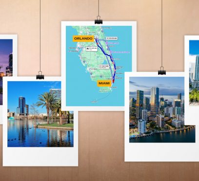
How Far Is Orlando From Miami? How To Travel By Road, Train And Air?
BY Sibashree Mar 23, 2026
Are you planning a Florida trip to see all the beaches in Miami? Florida definitely has the best beaches in the world and the best cuisine. Furthermore, with year-long sunshine, it boasts a vibrant culture, happening nightlife, and endless outdoor activities. Orlando, on the other hand, has Disney World, and it is the theme park capital. However, this time, I will not ask you to choose between the beach holidays and theme park adventures. You can easily travel from Miami to Orlando and experience the best of both worlds. So, in today’s blog, I will talk about how far is Orlando from Miami and how to travel the distance. Also, if you are planning a trip from Tampa to Orlando, you can read my guide. How Far Is Orlando From Miami? The distance between Orlando and Miami is around 236 miles or 380 kms. Furthermore, the travel time between Orlando and Miami is between 3.5 and 4.5 hours. However, the travel time will depend on the mode of transport you choose. So, here is a quick summary. Different Modes of Transport From Orlando to MiamiTravel TimeBy Car3.5 to 4.5 HoursBy Train3 Hours and 30 Minutes to 7+ HoursBy BusAround 4 to 6 HoursBy Air About 1 Hour Furthermore, Miami is served by the Miami International Airport, which is around 10 miles away from Miami. Moreover, the Orlando International Airport is at a distance of 12 miles. So, consider the travel time to and from the airports, which is around 1 hour, including both sides. Once you arrive, booking vacation rentals in Miami ahead of time will ensure you secure the best beachside or downtown accommodations for your trip. How To Travel To Orlando From Miami? The fastest way to travel from Orlando to Miami is by taking a flight. However, you can also travel by train, bus, and car. Here are the details. 1. How Far Is Orlando From Miami By Train? The travel time between Orlando and Miami by train will depend on the service you take. For example, if you take the Brightline Train service, you will travel the distance in about 3 hours and 30 minutes. Furthermore, the ticket price will range between $79 and $300 for a one-way ticket. You can also take the shuttle service offered by Brightline to explore the Miami Area. Take The Amtrak Trains For The Most Budget-Friendly Travel The ticket price for Amtrak Trains is about $35 to $102. Also, private room services are available at $288. Check out the departure and arrival timings of the Amtrak train. DepartureArrival7:05 AM12:22 PM11:05 AM6:34 PM 2. How To Travel From Miami To Orlando By Bus? RedCoach USA is the main bus service between Miami and Orlando. The travel time between these places is between 3 hours and 40 minutes and 4 hours and 5 minutes. Furthermore, the ticket price for this bus ride depends on the day of the week you are traveling. Ticket prices are higher on weekends. Moreover, the ticket price ranges between $39.99 and $107.99. 3. How To Travel From Miami To Orlando By Car? The car rental price for a one-way journey from Orlando to Miami is between $60 and $110. Furthermore, the leading car rental services on this route are Sixt and Alamo. Furthermore, you can take an Uber from Miami to Orlando. The rental cost starts from $317. 4. Traveling From Miami To Orlando By Air As I have mentioned, the Miami International Airport, at a distance of around 10 miles, and the Orlando International Airport, 12 miles away, are the two gateways. Moreover, American Airlines, Delta, and JetBlue are the main airline services on this route. Furthermore, the travel time by flight is around 1 hour, and the ticket price is about $250 to $300. How Far Is Orlando From Miami? Frequently Asked Questions (FAQs) Here are the frequently asked questions and answers about the Orlando to Miami distance. 1. Is It Better To Drive Or Fly From Orlando To Miami? The choice of a drive or a flight from Orlando to Miami depends on the kind of experience you want. For example, if you are traveling with family and want to keep the itinerary flexible, you can go for a drive. It is also way cheaper than a flight. On the other hand, if you want to travel very fast, take a flight, which completes the journey within 1 hour. 2. What Is The Cheapest Way To Get From Miami To Orlando? Amtrak train and RedCoach USA buses are the cheapest modes of transportation between Miami and Orlando. In both these services, the ticket price starts from around $34-$35. 3. How Much Is Uber From Orlando To Miami? The price for an Uber ride from Orlando to Miami depends on the type of service you are opting for.For example, the UberX service costs $317, the Uber Black service costs $671, and the UberXL services are available at $571. 4. How Far is Orlando To Miami By Plane? The Orlando to Miami distance by plane is about an hour. So, if you want to travel quickly, you can take a flight from the Miami International Airport to the Orlando International Airport. Furthermore, American Airlines, Delta, and JetBlue offer services on this route, and the ticket price will be about $250. 5. What Is The Best Time To Travel From Orlando To Miami? December to March or the winter season, and March to May or the spring season are the best seasons for a trip from Orlando to Miami. Furthermore, 8 AM to 10 AM or 3 PM to 6 PM are the peak hours on this route. So, travel outside these hours. Also, mid-week and weekends are the ideal times for a Miami to Orlando journey. Moreover, June to November is the Hurricane season. Especially mid-August to mid-September is the most difficult time for a drive from Miami to Orlando. In addition, car rental prices are higher on weekends and during peak seasons. So, if you want to save on car rental, choose the mid-week days.
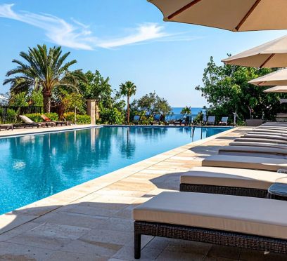
Margaritaville Palm Springs Reviews: Is It Ideal For A Family Vacation?
BY Sibashree Mar 23, 2026
A vast expanse of dry and shimmering heat lies in front of you, the Coachella Valley. The jagged peaks of the San Jacinto Mountains tower over you like ancient sentinels, reigning over the desert landscape. As you pull into the driveway of your home at the north end of Palm Springs, you will see typical desert décor: mid-century modern simplicity, a desert plant known as "desert sage." You may also find some Southern California old-time Hollywood glam. However, upon your arrival, you don't see a cactus garden or anything close to one. The things we are habituated to seeing at the Treasure Island Beach or the Laguna Beach in Southern California. Instead, you will be greeted with a 13-foot-long blue flip-flop located at the entrance lobby area, where the faint but delicious fragrance of coconut lime & ocean salt is present in the atmosphere. In 2020, the famous Riviera Resort (known as the 'playground' of Frank Sinatra and other members of what is referred to as "The Rat Pack") was totally renovated. Moreover, it has since opened as the first Margaritaville location on the west side of America. But do you know what is more special about this 24-acre island oasis? It shows a fascinating hybrid. It is an excellent fusion of the chic architectural bones of 1950s California and the "no-shoes, no-problem" philosophy of Jimmy Buffett. However, here the question is whether it is for families? I will unfold all the details in this Margaritaville Resort Palm Springs review. Let’s start with a dive into the history, though! How A Storied Past Meets A Salty Future At Margaritaville Palm Springs This hotel has existed since 1959, when it was known for being upscale and accommodating celebrities like Frank Sinatra and Dean Martin. Through time, the renovations at Margaritaville kept the structure's famous “spokes on a wheel” layout with six buildings for guest rooms radiating from an entrance lobby. However, it transformed the previous dark and dreary spaces into light and bright environments. Furthermore, with regards to what's in style these days, it's bright, open, and downright happy. Also, the lobby doesn't feel like a typical hotel lobby. It feels like an upscale beach house. Moreover, there are whimsical seating areas around the lobby and many nautical elements incorporated into the design of the space. The arrangements help parents know right away that they can sit back and relax because their children can act like children in this space. Margaritaville Resort Palm Springs Reviews: The Hotels, Rooms, Food And Family-Friendliness So, does a stay at the Margaritaville Resort Palm Springs feel great on a family vacation? Or, does the luxury here translate into comfort? Let’s find out! 1. The Layout Of The Hotel: Navigating The Oasis The resort features a large amount of grounds (24 acres of beautifully landscaped area) to be enjoyed by guests. While the property size may seem large upon arrival, it is actually one of the resort’s greatest assets as well. Moreover, the resort buildings are separated across a large area and provide each guest with enough privacy and room to be away from a typical hotel tower. • The Central Hub The resort's heart is the central hub where the 5 o’Clock Somewhere Bar sits surrounded by fire pits, lounge chairs, and the main pool. • Quiet Corners Beyond the central pool, there are large open outdoor spaces and private gardens, as well as places to escape the music, people, and hustle of the resort. • The Spa At St. Somewhere Palm Springs' largest resort spa has everything you need for relaxation away from your kids. Encompassing 11,000 sq ft net of the highest level of service and comfort, there is something for everyone. Moreover, you will walk away as if you were in St. Barts after 1 week of goodness with our "Parrot Head" (the place you want to be) pedicure to deep-tissue massage. 2. The Rooms At Margaritaville Palm Springs The resort is a vibrant retreat developed for ultimate relaxation. The spaces showcase examples of the 'coastal-meets-desert' chic interior by incorporating high-end island decor and furnishings. Furthermore, the resort has 398 guest rooms and suites for its customers and offers a vibrant retreat developed for ultimate relaxation. The accommodation has a range of modern and thoughtful features, including the following. Free Wi-Fi Smart TV Professional Hair Dryer Coffee and Tea Service Mini Fridge Multiple Room Options For Families Rooms are available in a variety of sizes and designs. Standard options have king beds and sleeper sofas. Most rooms come with a balcony. Families can also opt for rooms containing two king beds. This offers a greater amount of room and comfort when compared to a standard double queen room. Most rooms come with a balcony to enjoy the beautiful views of the San Jacinto mountains or an energetic patio for those wanting to relax. 3. Dining At Margaritaville Palm Springs A Margaritaville experience wouldn’t be complete without its food offerings. The resort features several unique dining choices to suit various tastes and budgets. • Come Monday Café Situated near the lobby, this venue is perfect for breakfast, lunch, and dinner, providing a laid-back atmosphere with a lovely outdoor patio. • JWB Grill For a more sophisticated dinner, JWB (named in honor of James William Buffett) offers an elegant menu in a stylish environment. • Joe Merchant’s Coffee & Provisions This is the ideal place for a quick bite. Whether you need a caffeine boost, a breakfast sandwich, or a salad to enjoy by the pool, this spot is convenient and a bit easier on the wallet. • 5 o'Clock Somewhere Bar The perfect poolside hangout serving chips, salsa, burgers, and, of course, their famous margaritas. What Works For Families At Margaritaville Palm Springs? Margaritaville stands out in several areas that simplify life for parents. It is great for a family trip for the following reasons. • The Double King Room While most hotels provide two queen beds, which can feel cramped for a family of four, Margaritaville offers accommodations with two king-size beds. Also, this significantly improves sleep quality and personal space. • Poolside Convenience The attentive staff allows you to order lunch and frozen drinks right from your lounge chair. This means you won’t need to drag wet, hungry kids back to your room or into a formal dining area for a midday bite to eat. • Built-in Entertainment The resort fee covers free bike rentals, making it easy to explore the serene, breezy streets of the nearby neighborhood, along with complimentary high-speed internet for those unavoidable evening tablet sessions. • The Evening Atmosphere As night falls over the mountains, the resort transforms. Fire pits are ignited, and the outdoor patios turn into "enchanting" spaces adorned with lanterns hanging from the trees. Moreover, it creates a sophisticated vibe for adults while remaining completely welcoming for kids. What Does Not Work For Families At Margaritaville Palm Springs? For me, the first inconvenience at the resort started with the talk. The building we were assigned to was quite a long walk from the pool. Furthermore, during weekends, with the crowd surge, it was a bit difficult for my kids. What Are The Places To Visit Near Margaritaville Palm Springs? Beyond the 24-acre sanctuary, these are the places you can visit. The Living Desert Zoo & Gardens The Children’s Discovery Museum of the Desert Indian Canyons Furthermore, don’t forget a ride in the Palm Springs Aerial Tramway up to the top of Mount San Jacinto.
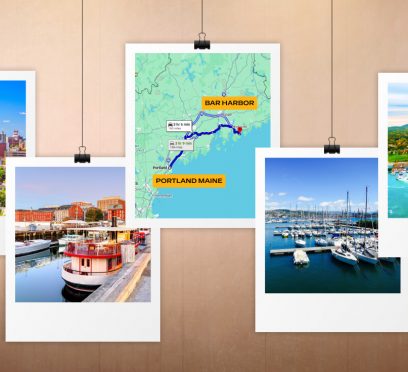
What Is The Portland Maine To Bar Harbor Distance? Exploring Coastal Maine By Car
BY Sibashree Mar 23, 2026


