
Where Is Uppuveli Beach, Trincomalee? What Are The Best Things About The Beach?

After spending time in the northern city of Jaffna exploring everything it has to offer, I was looking forward to relaxing. 

Jaffna has some beautiful temples, and despite being a slow travel destination, the rich Tamil culture and history offered a fulfilling experience. 

However, I needed a place where I could relax and soak in the memories I have collected there.

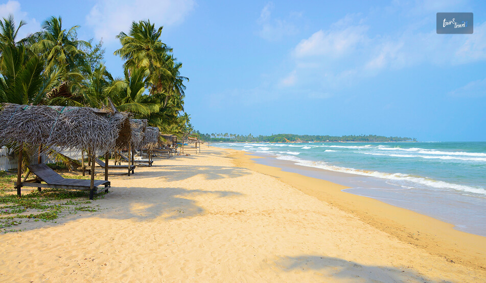
I intended to enjoy just those “beachy” times when I arrived at Trincomalee, and that is exactly what I found on the Uppuveli Beach. 

This was the ultimate “holiday within my backpacking trip,” and completely different from the beaches in Jaffna.

Where Is The Uppuveli Beach?

Where Is The Uppuveli Beach

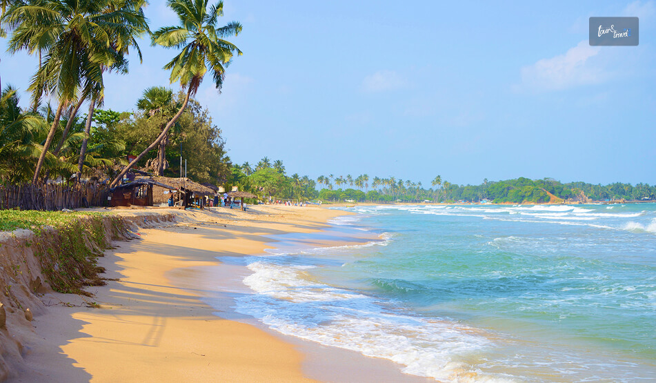
Uppuveli Beach is in Trincomalee. On the northeastern coast of Sri Lanka, it is further the epicenter if you are exploring the things to do in Trincomalee. 

The distance between the Uppuveli Beach and the Trincomalee city center is just 6 kilometers. So, you can reach within a drive of just 15 minutes. 

Moreover, it is famous for the beauty of the Bay of Bengal, and from here you can explore nearby attractions such as the Pigeon Island Marine National Park and Swami Rock.

How To Reach Uppuveli Beach From Trincomalee? The Blue Bus Experience?

You can travel from Jaffna to Trincomalee by bus like me. Trincomalee, anyway, is a major transport hub. 

Furthermore, it is well-connected to Colombo, Kandy, and even Habarana, which is the major gateway to many other things to see in Sri Lanka, such as the Hurulu Eco Park, Sigiriya Rock, the Pidurangala Rock, and the Kaudulla National Park. 

I reached Trincomalee from Jaffna by bus within 4 hours and 50 minutes. However, our driver, Ahoy, said that on days of dense traffic, it can take up to 5 hours and 30 minutes. 

Travel From Jaffna To Trincomalee By Bus

The blue buses from Jaffna to Trincomalee are the cheapest mode of transport. The ticket cost roughly 1100 LKR. 

From Trincomalee To Uppuveli Beach 

From the Trincomalee Bus Station, I took a tuk-tuk to the Uppuveli Beach. The tuk-tuk driver charged me 500 LKR. 

The Experience At Uppuveli Beach 

The Experience At Uppuveli Beach

Uppuveli Beach is the place that offers you simplicity, and here, you will forget keeping track of your time. 

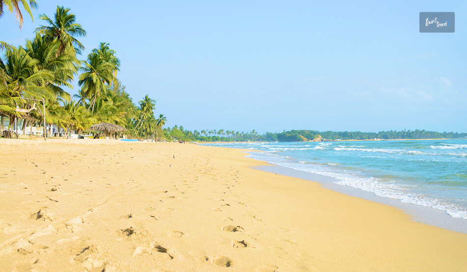
You can swim, sunbathe, or just soak in the beauty of the golden hour, or just soak in the beauty of golden hour or count the waves like me. 

The Golden Hour

See a sunset on the beach while it’s still dark out. 

Uppuveli faces the east, and it offers an amazing view of the Bay of Bengal when the sun rises. 

The sky looks like it’s on fire with shades of pink and gold lighting up the clouds. 

The Waves

The waves were huge when I was there in July.

The waves here rise really high above your head and can definitely knock you over if you don’t pay attention to them when swimming. 

If you can catch the waves just right, they are also great for body surfing. As always, be respectful of the Indian Ocean. 

What Are The Things To Do At Uppuveli Beach?

What Are The Things To Do At Uppuveli Beach

Uppuveli offers a serene alternative to the more crowded southern beaches. 

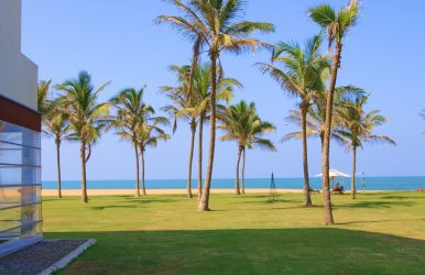
Boasting breathtaking turquoise waters and palm trees swaying in harmony with one another, Uppuveli is a welcoming community that exudes a sense of calm.

1. Marine Adventures At Pigeon Island Marine National Park

The number one attraction in Uppuveli is Pigeon Island Marine National Park. 

A 20-minute boat ride from the beach will take you to Pigeon Island, a protected sanctuary surrounded by colorful and lively coral reefs. 

Pigeon Island is famous as one of the three places in the world where you can see black-tip reef sharks and giant sea turtles in the shallow waters (up to 12 feet). 

You may also dive deeper by visiting several local dive shops that operate daily excursions to the Uppuveli Pinnacles and the famous shipwrecks in and around Uppuveli. 

Local dive shops also provide excursions between March and September to boat watch for blue whales and pods of spinning dolphins.

2. Visit The Cultural Landmarks Of Swami Rock

You may take a short tuk-tuk ride to the Swami Rock Temple located in Trincomalee town. 

Swami Rock is perched on a cliff and provides some of the best views of the ocean as you look towards the Koneswaram Hindu Temple, which is located in the middle of the cliff and overlooks Trincomalee Harbor.

The temple is dedicated to Shiva and is a great example of intricate Dravidian-style architecture. 

In addition to the temple at Swami Rock, you will also see Lover’s Leap, which is nearby and steeped in local folklore.

3. Visit Fort Frederick And Find Spotted Deer

On your way to the Koneswaram Temple, be sure to visit Fort Frederick.

It is a 17th-century fortress built by the Portuguese. 

Fort Frederick today is a peaceful area. It has many spotted deer, and you can see them roaming freely between colonial buildings and massive banyan trees.

4. Kanniya Hot Water Springs

For something unique, head inland to the Kanniya Hot Water Springs. 

There are seven stone wells here, each producing water at a slightly different temperature. 

It’s a traditional site for ritual bathing. Also, people believe that water here has healing properties.

Moreover, at Uppuveli Beach, you can have the best dining and drinking experience thanks to places such as Fernando’s Bar, Rice ‘n’ Curry, and Cafe on the 18th.

Also, you will find Wanderers Hostel and other budget-friendly places to stay near the Uppuveli Beach. 

When Is The Best Time To Visit Uppuveli Beach? 

The best time to visit Uppuveli Beach is between February and August, and July is the peak month. 

From August, the ocean starts getting a little rougher. 

Moreover, as I have mentioned, it is best to hit the beach when it is still dark. Thus, you can enjoy the magic of the sunrise. 

Also, if you want a drink by the sea, 3:30 PM to 4 PM will be the best. As you gulp down some cold Lion Lager, the Sun prepares to go to rest for the day.

Share on Social Media

Sibashree is a travel, culture, and leisure writer who has been writing since the age of 12 and professionally since 2014. With more than a decade of travel writing experience and journeys across India and several parts of the world, she brings a deeply personal and thoughtful perspective to her work. A student of English Literature and Mass Communication, Sibashree has always viewed travel as more than movement — for her, it has been a way of understanding people, cultures, and herself. Her passion for spiritual exploration has also led her to many unusual and meaningful destinations over the years. Outside of writing, Sibashree enjoys watching European cinema, reading about global politics, and reflecting on the stories hidden within everyday places.

Leave a Reply

Your email address will not be published. Required fields are marked *

title-img Related

READ MORE Anuradhapura

What Are The Best Places To See In The Sacred City Of Anuradhapura, Sri Lanka? 

BY  Sibashree Apr 21, 2026

Anuradhapura is a part of the Golden Triangle of Sri Lanka along with the Dambulla Royal Cave Enclave, Polonnaruwa, and Sigiriya Rock Fortress.  Furthermore, the Sacred City of Anuradhapura, a UNESCO World Heritage Site, was built from the “cutting of a Bodhi Tree” or the “Tree of Enlightenment.”  Before 993, when it was abandoned due to an invasion, it was the political and religious capital of Ceylon, the previous name for Sri Lanka.  Also, if Jaffna attracted me with its Tamil Culture and Hindu Temples, Anuradhapura was a great calling because it was the first place to adopt Buddhism outside India, the country I belong to.  Moreover, Jetavanaramaya, the early 4th-century BCE Stupa, was once the “third-largest man-made building in the world,” with an original height of 122 meters.  However, while the Jetavanaramaya Stupa continues to evoke awe with its grandeur and mystery, the other ruins and remains of Anuradhapura also wait to tell you the history and cultural richness of the region.  So, here is a brief discussion on the places I visited in Anuradhapura.  What Are The Places To Visit In Anuradhapura?  I was staying in a guest house near the Sacred City of Anuradhapura. I rented a bicycle from my guest house for LKR 500, and I took the back route as the staff in the guesthouse guided me.  Off the main road, the cycling experience was beautiful, and I loved spotting the roaming peacocks and little children waving at me.  Beyond the charming views and ambiance, I noticed one more thing. In Anuradhapura, the past and the present walk side by side.  There have been no evictions of the locals in the name of preserving or promoting the ancient ruins and remains in a UNESCO World Heritage Site.  Nevertheless, after talking to the local children for a while, I reached the entrance of the Anuradhapura Sacred City. The entry fee was around 9500 LKR or INR 2800.  However, remember that the ticket includes archaeological sites such as Jetavanaramaya, Abhayagiriya, Ruwanwelisaya, and Thuparamaya. So, if you want to explore other sites such as the Isurumuniya Viharaya, you will need to pay separate fees.  Nevertheless, these are the places I visited in Anuradhapura.  “This sacred city was established around a cutting from the 'tree of enlightenment', the Buddha's fig tree, brought there in the 3rd century B.C. by Sanghamitta, the founder of an order of Buddhist nuns.  Anuradhapura, a Ceylonese political and religious capital that flourished for 1,300 years, was abandoned after an invasion in 993.  Hidden away in dense jungle for many years, the splendid site, with its palaces, monasteries, and monuments, is now accessible once again.” - UNESCO World Heritage Convention.  1. Abhayagiri Vihara Stupa Complex The Abhayagiri Vihara Gargantuan Stupa is magnificent, and the brick stupa creates a contrast against the bright blue sky and the lush greenery of Anuradhapura.  King Vattagamani Abhaya or Valagamba founded this Stupa in the first century BCE. This prominent center of Mahayana Buddhism remains an active place of worship.  Also known as the Northern Monastery or Uttara Vihara, it changed the course of Buddhism in Sri Lanka by deviating from the monolithic tradition of Theravada Buddhism.  Moreover, the Abhayagiri Vihara Stupa is the first Stupa in Sri Lanka to house the tooth relic of Buddha.  Also, the Abhayagiri Dagoba or Stupa at the epicenter of the Abhayagiri Vihara Complex is one of the largest stupas in Sri Lanka.  The Structure And Architecture Of The Abhayagiri Vihara Apart from the Stupa or Dagoba, most parts of the Abhayagiri Vihara are in ruins. There were living houses for the monks and students, libraries, dinner halls, and meeting halls surrounding the Stupa.  Here is a detailed overview of the structures as I saw them. However, the heat will be scorching, and you will find langur monkeys roaming around.  So, try to be there by 6 AM, when the gates open, or after 4 PM. The Sacred City remains open till 8 PM. However, it will take you around an entire day if you want to explore the major ruins of the Anuradhapura Sacred City. The Dagoba Or The Stupa  The Stupa or Dagoba in the Abhayagiri Vihara is in a well-preserved condition. The massive bell-shaped structure of the stupa has a height of around 120 meters, and at its widest, the circumference is close to 350 meters.  The dome, made of brick and lime mortar, has four entrances, and you will find a Devatakotuva or a cylindrical spire and Hataraskotuva or a square-shaped structure as the crowns of the Stupa.  Image Houses, Refectories, And Sub Shrines  I saw the remains of various refectories, image houses, living complexes, and sub-shrines around the stupa.  Among the smaller stupas, the Indikatu Seya and Silasobbhakandaka Cetiya are the most common.  Meeting Halls The remains of the meeting halls or Uposathagharas have been found in the complex.  These Uposathagharas were multi-storied, and Ratnaprasadaya or the jewel mansion was most prominent among them.  Congregation Hall The Sannipatasala, or the congregation hall near the southern entrance of the stupa, is the largest hall in the complex.  The image of Nagaraja, or the king of snakes, or Virupaksha, the protector of the Western Direction, was found in this congregation hall, which is now in ruins.  You can see this image at the Abhayagiri Museum.  Abhisheka Mandapa Or Anointing Pavilion The Abhisheka Mandapa had a stepped entrance, and people believe it to be the place where the statues of Lord Buddha and other Bodhisattvas were consecrated.  Some even consider this the bathing house or Snanghara.  Stone Slabs  Many stone slabs with inscriptions in Nagari Script have been found in this site.  Again, there are two moon stones in Anuradhapura, and one was found at the Queen’s Pavilion and the other at Mahasena’s Palace.  These moon stones are significant features of Buddhist stupas or shrines, as these semi-circular stone structures depict the Buddhist Samasara.  The Dining Room The dining room or hall of the Abhayagiri Vihara has a stone-clad trough, and it is ideal for storing or serving rice that could feed 5000 monks.  Furthermore, there was a dining area, hearths, underground channels, grinding stones, and a sundial in the site Faxian or Fa-Hien described as the dining hall.  The dining hall also has two courtyards.  The Bodhi Tree Shrine The Bodhi Tree Shrine, or the Bodhighara is a subsidiary shrine of the Abhayagiri Stupa. As a token of Buddha’s enlightenment, Sanghamitta, a Buddhist nun from India, brought saplings of the Bodhi Tree.  She planted the saplings in Abhayagiri, and many patrons built small aediculae-like shrines around these trees.  These sub-shrines had images of Lord Buddha in a meditative or Samadhi posture and his footprints.  Moreover, excavation of Buddha statues took place in the Bodhighara sites, and one of them is from the 3rd century BCE, and these resemble the sculptures of the great Gupta dynasty in India.  You can visit the Anuradhapura Archaeological Museum if you want to see these Buddha statues. The Ponds  The tanks and reservoirs near the living quarters were the main sources of water for the complex.  However, water in these reservoirs or tanks came from the Kuttam Pokana or Twin Ponds to the far east of the Stupa.  Moreover, these rectangular ponds were built by Aggabodhi I in the 6th or 7th century CE, and they have shallow ridges, and the inner walls are made of polished stone.  However, for me, the most fascinating thing was the stone slab with the motif of a hooded cobra.  Also, this hooded cobra or Naga establishes a deep connection with India, as Nagas and water have deep connections in Indian mythology.  As I walked further, I came across the Elephant Pond or Eth Pokuna. It is the largest artificial tank in Sri Lanka, and it is the main water supply for all the tanks and reservoirs in the Vihara Complex.  Here also, I noticed a depiction of a hooded cobra on a stone slab.  At the end of exploring the Abhayagiri Vihara Stupa Complex, I must tell you that you must read a little about the place before a visit.  Otherwise, it will be difficult for you to catch up when the guide shares the details.  2. Jethawanaramaya Stupa You will also find the Jetavanaramaya Stupa in the Sacred City of Anuradhapura. It was one of the largest man-made structures in the world, and it ranked only after the Great Pyramids of Giza.  The original height of this structure was 122 meters, and after restoration, the height is now 71 meters.  The stupa, built by King Mahasena in the 3rd Century AD, is a part of a large Jetavana Vihara complex that used to house around 200 monks. Also, like the Abhayagiri Vihara, it has a brick architecture.  This once again indicates how ancient Anuradhapura was a hub of brick production. In fact, Ruwanwelisaya, the most sacred stupa of the country inside the Anuradhapura Sacred City Complex, also had a brick architecture.  However, for the recent restoration, they used cement in the outer layer of the stupa.  Moreover, massive excavation works have taken place in the Sacred City of Anuradhapura, and the gold panels showing the imagery of the Bodhisattva and the partial inscriptions of the Prajñāpāramitā Sutra.  Now, Prajñāpāramitā Sutra is the foundational text of Mahayana Buddhism. This shows how the Jethawanaramaya Stupa was the hub of different Buddhist thoughts and schools. However, you can see these gold panels now at the Colombo Museum.  Also, I came to know about another fascinating thing from a monk here, that the stupa used to have a diamond in the crown. It used to turn aside lightning during the monsoon season.  3. The Gleaming White Ruwanwelisaya Stupa  The Ruwanwelisaya Stupa is most famous among the locals and followers of Buddhism.  Now, unlike the Ritigala Forest Monastery, the Ruwanwelisaya Stupa or the other stupas in the complex are live hubs of Buddhist practices.  Also, the Ruwanwelisaya Stupa is especially famous for housing the remains of Lord Buddha.  Originally, the Ruwanwelisaya Stupa was much smaller than the Jethawanaramaya Stupa. However, thanks to continuous maintenance, it now stands at a height of 100 meters.  Now, this was my experience in the ancient ruins of Anuradhapura. If you want to explore more, you can visit the Kaudulla National Park, at a distance of less than 2 hours, and the Hurulu Eco Park, at a distance of 1 hour and 50 minutes.   Location And How To Reach Anuradhapura?  Anuradhapura City is located on the banks of the Malwathu Oya. It is the capital of the central-west region of Sri Lanka and the district of Anuradhapura.  Anuradhapura is a 4-hour journey from Colombo and Kandy.  Once I explored the top attractions in Kandy, I took a minivan, which cost me LKR 1600. Now, you will also get private and public buses.  However, I had luggage and wanted to keep the schedule flexible. So, I chose the minivan.  Things To Remember For A Trip To Anuradhapura The Sun is merciless in Anuradhapura, even if you visit the Sacred City in winter. It becomes unbearable past 11 AM.  So, you have to really start early.  Also, carry water and wear full-sleeve clothes to maintain the dignity of the place and protect your skin from the Sun.  Moreover, as I have mentioned, visiting a place like Anuradhapura demands preparation. So, study well and have basic ideas about these stupas beforehand. 

READ MORE Knuckles Mountain Range

Knuckles Mountain Range Sri Lanka: A Guide To The Wildest Central Highlands Of Sri Lanka

BY  Sibashree Aug 21, 2026

I saw the Knuckles Mountain Range from a distance, and I knew where it got its name from.  Near Riverston, the ridgeline transformed into a row of rounded peaks with unique folds. The folds further made it look like a clenched fist against the sky. I was expecting an extension of Nuwara Eliya or the charm of Ella in the Knuckles Mountain Range.  However, instead of the tea estates, I got days of cloud forest, leech socks, village guides, and a silence so complete that I could hear my own footsteps on the trail. Also, if you have loved Horton Plains National Park, you will definitely cherish the Knuckles Mountain Range, the less-polished and wilder counterpart. Where The Knuckles Mountain Range Is And The Mystery Behind Its Name The Knuckles Conservation Forest is in the Central Highlands of Sri Lanka. It is between the Kandy and Matale districts and at a distance of around 30 to 40 kilometers northeast of Kandy Town. Furthermore, it stands between the Kandy and Matale districts.   The Mountain Range gets its name from five or six peaks that you can see from certain angles. These peaks, with their folds and unique round shapes, resemble knuckles on a closed fist. However, the local name for the mountain range is Dumbara Kanduvetiya. The name means the "misty mountain range."  Honestly, I could relate to this name more during my visit. On the two days I visited the mountain range, the Sun was not out even when it was 9 AM.  In 2010, the Knuckles Mountain Range got the designation of a UNESCO World Heritage Site as part of the Sri Lankan Central Highlands listing.  It got the designation because of how many distinct climate zones and endemic species are packed into a relatively small area. How To Reach The Knuckles Mountain Range? Most people base themselves in Kandy or the small village of Meemure, Corbett's Gap, or Hunnasgiriya before heading in. I stayed in a homestay near Hunnasgiriya, which cut my morning drive to the trailhead down to about 40 minutes. FromDistanceApprox. Travel TimeKandy30–42 km (depending on trailhead)1.5 to 2 hours by tuk-tuk or carColombo140 km4 to 4.5 hours by carMatale25 km1 hourDambulla45 km1.5 hours There is no train access into the range itself. So, a hired vehicle, tuk-tuk, or your own transport is essentially mandatory.  Roads narrow into single-lane gravel past Loolwatte, and a couple of the approach roads are only comfortable in a 4WD or trail bike during monsoon months. What Makes Knuckles Different From Other Highland Parks If you have already read up on Horton Plains, you will know that the park is essentially a single well-marked loop trail to World's End.  Knuckles is the opposite. It is a sprawling, largely unmarked forest reserve with more than 35 identified peaks and a dozen-plus trail combinations, most of which require a local guide. I hired mine through the Forest Department office near the Wattegama entrance, and I am glad I did. Without him, I would have missed the point entirely where the trail splits toward Deer Park versus the summit route. Flora And Fauna The range spans five distinct climatic zones within a 20-kilometer radius, which is unusual anywhere in the world.  On my hike, I moved from dry-zone scrub near the base, through a submontane forest thick with orchids, into genuine cloud forest by midday, where the canopy dripped constantly even without rain. FeatureDetailsElevation range300 Meters to 1,863 Meters (Knuckles Peak)Endemic plant speciesOver 160 RecordedBird speciesAround 128 Bird Species, including the Endemic Sri Lanka Whistling ThrushNotable wildlifePurple-faced LangurRusty-Spotted CatKandyan DrongoBest known peaksKnuckles PeakGombaniyaCorbett's GapDeer Plateau I did not spot the rusty-spotted cat, and almost nobody does. However, I did have a long, unbothered staring match with a purple-faced langur troop near Deer Park, and the birdlife alone was worth the leech bites. Popular Trails And What To Expect You can choose the loops and trails in the Knuckles Mountain Range based on the kind of experience you want.  The Meemure Loop This is the trail most guides recommend for a first visit. It is a roughly 10-kilometer loop through the traditional village of Meemure, one of Sri Lanka's most isolated settlements. It is still reachable only by a single mountain road.  I spent a night here in a village home, ate red rice and jackfruit curry cooked over a wood fire, and left with a much better sense of why people describe Knuckles as a living landscape rather than just a park. Corbett's Gap And Riverston If you have limited time, Riverston is the easiest win.  It is a short drive-up viewpoint rather than a trek, and on a clear morning the "Bible Rock" formation and the valley below are genuinely dramatic.  I would treat this as a half-day add-on rather than the main event. Knuckles Peak Summit Trail This is the demanding one.  It is approximately a 14-kilometer round trip with a real elevation gain, usually done as a full-day hike starting before dawn.  Expect grassland patches, patana grass ridgelines, and a scramble near the top.  I would not recommend it without a guide or without reasonable fitness. Parts of the descent were harder on my knees than the climb up. TrailDistanceDifficultyTime NeededRiverston / Corbett's Gap1–2 Km ViewpointsEasy2–3 HoursMeemure Loop10 KmModerateFull day / OvernightKnuckles Peak Summit14 km round tripChallengingFull day (Start Pre-Dawn)Deer Park Trail6 KmModerateHalf Day Practical Tips From My Trip Leeches are real and constant in the wetter zones, especially June through September. So, leech socks aren't optional; I learned this the hard way on day one. Weather flips fast. I packed for cold cloud-forest mornings and sweated through humid valley afternoons on the same day. A guide is genuinely necessary for anything beyond Riverston. Trails are not signposted, and the Forest Department requires registered guides for most routes anyway. The best season is broadly February to April and August to September, avoiding the heaviest southwest monsoon rains. Phone signal disappears past Hunnasgiriya on most networks, so download offline maps beforehand. Entry to the Knuckles Mountain Range is free. However, based on the loop you take, the trekking and permit charges will be between LKR 1000 and LKR 2500.  Where To Stay Near The Knuckles Mountain Range? Options are simple by design. This is not a resort destination.  Homestays in Meemure and Loolwatte give the most authentic experience. On the other hand, Hunnasgiriya and Corbett's Gap have a handful of small eco-lodges with better amenities if you want a hot shower after the hike. Knuckles Mountain Range: The Ultimate Remoteness Of Sri Lanka Knuckles won't give you the manicured, easy-access experience of Horton Plains or the tea-country views of Nuwara Eliya.  What it gives instead is a genuine sense of remoteness. I found village life largely untouched by tourism, a forest that changes character every few hundred meters of elevation, and trails that still require a bit of local knowledge to navigate.  If World's End felt like Sri Lanka's highlands on display, Knuckles felt like walking into them.  I am already planning a return trip to attempt the summit trail from the Deanston side, weather permitting.

READ MORE Mulkirigala

Mulkirigala Raja Maha Vihara: Know The Dambulla Of The South Or Little Sigiriya

BY  Sibashree Sep 10, 2026

I was confused when I first heard about Mulkirigala. Some called it the Dambulla of the South because of its multi-level cave complex structure.  Also, some called it Punchi Sigiriya or Little Sigiriya because of the massive natural rock outcrop and the vertical cliffs resembling the Sigiriya Rock Fortress.  Furthermore, to be honest, Mulkirigala was not on the bucket list I had before flying into the deep south of Sri Lanka. I was more interested in Mirissa's whale-watching boats and Hiriketiya's crescent bay. However, a guesthouse owner in Dikwella insisted that I must visit this rock temple older than Sigiriya.  It was just forty minutes inland, and I could expect it to be way less crowded than the Dambulla Royal Cave Temple.  That combination of history and near-total quiet attracted me. This combination is rare in the tourist circuit of Sri Lanka.  So, I could not help rearranging one morning around the spot.  As a reward, I could explore a working monastery carved into and around a 205-meter granite outcrop.  It had cave shrines and murals from the Kandyan era.  Also, it had a stone staircase climbing through five distinct terraces to a stupa with views over the Hambantota jungle canopy.  In this article, I will discuss what I found at Mulkirigala Raja Vihara, what it costs, and what it takes to get there now.  There are also some heartfelt inputs about why I feel it deserves a place on more southern-coast itineraries than it currently gets. Mulkirigala Raja Vihara At A Glance DetailInformationFull nameMulkirigala Raja Maha Vihara (also spelled Mulgirigala)Local nicknamePunchi Seegiriya (“Little Sigiriya”)Dambulla of the SouthLocationMulkirigala village, Hambantota District, Southern ProvinceRock heightAbout 205 metres (673 ft) above the surrounding plainOriginsTraced to the 3rd century BCRecorded in the chronicle Bodhi Vamsa as “Giriba Vihara.”StructureFive terracesSeven cave shrinesGranite stairways to climb upNearest townsAbout 2 km from Mulkirigala Junction.Reachable from Beliatta, Dikwella, or TangalleProtected statusDeclared an archaeological protected monument (Gazette No. 501, 8 April 1988) A Temple Older Than Sigiriya, And Quieter Too Mulkirigala predates Sigiriya.  Long before Kashyapa built his fortress-palace in the 5th century AD, this rock was already a site of Buddhist worship. It stayed in continuous use through the Anuradhapura, Polonnaruwa, and Kandyan periods.  The temple I actually walked through, including the murals, the seated and reclining Buddha statues, and the ceiling paintings, mostly date to an 18th-century restoration. Kandyan king Kirti Sri Rajasinha led this restoration work after the prolonged disrepair, following the reign of Parakramabahu the Great. The current entrance fee is a modest 500 Sri Lankan rupees for foreign visitors. Additionally, if you are driving or traveling in a car for a round trip, the parking fee will be LKR 100.  How To Reach Mulkirigala Raja Vihara? Mulkirigala sits inland from the coastal belt between Tangalle and Matara. So, it is an easy half-day detour from any of the beach towns in that stretch rather than a destination requiring its own overnight stay. From Tangalle Or Dikwella This is the most common route to reach Mulkirigala, and I traveled from Dikwella.  It was a tuk-tuk ride of around 40 minutes, and it was alongthe  Beliatta–Weeraketiya road. The tuk-tuk turned off at Mulkirigala Junction and continued for around 2 km to the base of the Mulkirigala Raja Vihara. The tuk-tuk charged me around LKR 2700.  I opted for a half-day hire along with waiting time.  Here, the exact fare of the tuk-tuk will depend on your negotiation skills and waiting time.  From Mirissa, Weligama, Or Matara If you are staying further up the coast, both Tangalle and Dikwella are accessible via the Southern Expressway. So, Mulkirigala is an easy stop on a day loop that also takes in Dikwella's Blue Beach or the Hoo-maniya blowhole.  A hired car or tuk-tuk for the day is the practical option, as there is no direct public bus to the temple itself. You will get a bus only to Beliatta town, from where a three-wheeler covers the last stretch. Climbing The Five Terraces The site is organized into five ascending sections. The climb is a mix of stone stairways and short paved paths. So, it took me a little over an hour up, with time to linger in each shrine, plus a shorter descent. TerraceWhat's TherePatha Maluwa (Lower Terrace)Ground-level entrancePilgrim's rest areaMonks' quarters (Sanghavasa)And the small site museumBodhi Maluwa (Bodhi Tree Terrace)The Bodhi tree has grown from one of the 32 original saplings of Anuradhapura's Jaya Sri Maha Bodhi.Raja Maha Vihara Maluwa (King's Temple Terrace)The main cluster of cave shrines, with reclining, seated, and standing Buddha statues and 18th-century murals.Uda Bodhi Maluwa (Upper Bo Tree Terrace)A second Bodhi tree terrace partway up the rock, a natural resting point before the final climb.Chaitya Maluwa (Stupa Terrace)The summit stupa and open rock platform, with panoramic views over the Hambantota jungle and, on clear days, toward the coast. The Discovery Of The Vamsatthappakasini Or Mahawamsa Tika In The Cave Temple In one of the caves on the upper terraces was the place where British civil servant George Turnour discovered palm-leaf manuscripts of  Vamsatthappakasini or Mahawamsa Tika in 1826 to 1827.  It made the translation of the Mahawamsa Tika possible, making the great historical chronicle of the island more accessible.  I was standing in that cave. It was dim and cool and felt comforting after the heat of the open stairways.  However, when I heard about the discovery and its significance, I felt like I was standing inside a footnote of how Sri Lankan history actually got written down. Also, the Dutch called the same cave “Adam’s Berg,” as they believed it held the tombs of Adam and Eve.  The Murals Of  Mulkirigala Raja Maha Vihara And What Makes Them Different Dambulla and Mulkirigala caves felt similar in structure, with reclining and seated Buddhas against painted walls and ceilings. However, the palette and iconography here were different.  Several shrines in the cave temple have a mix of Hindu deities and motifs alongside the Buddhist imagery.  These once again indicate the layered past of the cave temple.  Also, with these Hindu images, the cave temple shows long, continuous use across different periods of patronage rather than a single unified building campaign. The murals as they stand today mostly belong to the Kandyan-era restoration. They have flat perspective, bold outlines, and an ochre-and-blue palette typical of royal temple painting from that period. Moreover, the caves here are smaller than Dambulla.  I spotted around a dozen other visitors across the entire site during the two hours I spent there.  Practical Information For Visiting The Mulkirigala Raja Maha Vihara Things to KnowDetailsEntrance Fee (Foreigners)Approximately LKR 500 Per PersonOpening HoursGenerally Dawn to DuskMost Visitors Arrive between 8:00 AM and 4:00 PM.FootwearTake Your Shoes and Hats off at Every Shrine.Expect to Walk Parts of the Site Barefoot on Warm Stone.Dress codeKeep Your Shoulders and Knees Covered.GuidesInformal Guides often Approach Near the EntranceAgreeing a Fee Upfront is Optional but Common.WildlifeResident Macaques are Common on the Stairways.Time Needed1.5 to 2.5 Hours Round Trip, depending on Pace and Photo Stops. A Half-Day Itinerary Around Mulkirigala Because the temple only takes a couple of hours, it pairs naturally with the beach towns nearby.  TimeStopNotes8:00  AMDepart Dikwella or Tangalle.Beat the midday heat on the staircases.8:40 AMArrive at Mulkirigala.Start the climb through the five terraces.10:30 AMDescend and browse the site museum.Lower terrace, near the entrance.11:15 AMReturn toward the coast.Stop at Mulkirigala Junction for a roadside lunch.1:00 PMDikwella's Blue Beach or Hoo-maniya blowhole.Cool off after the climb.3:30 PMHiriketiya or Tangalle.Sunset by the water. Why Is Mulkirigala Raja Maha Vihara Worth The Detour? Mulkirigala does not have the recognition of Sigiriya, for example, the UNESCO designation.  Instead, it offers a rock temple with an older foundation and murals worth the climb.  So, suppose your route already runs along the south coast between Matara and Tangalle. Then, it is a half-day that repays the small effort of getting there. It is an easy add-on alongside the beach and blowhole stops around Dikwella.  You can also see this as a cultural counterweight to a coast-heavy itinerary that otherwise skips temples entirely.  For a fraction of what the bigger cultural-triangle sites charge, you get the staircases, the caves, and the history, just without the crowds.