


Travel Considerations For Out-Of-Town Facial Plastic Surgery Patients
BY Sibashree Jul 7, 2026
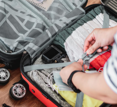
Opting for out of town plastic surgery has become an increasingly common practice, where patients seek specialized surgeons and advanced procedures. This is done because of a lack of availability for specialized services that are close to home. Whether you are planning a rhinoplasty, eyelid surgery, neck lift, or a facelift, careful travel planning can make a significant difference in both your experience and recovery. From scheduling consultations to arranging post-operative care, taking the time to prepare helps reduce stress and allows you to focus on healing. 1. Start Planning Your Trip Early One of the most important steps is giving yourself enough time to organize every aspect of your trip. Last-minute arrangements can create unnecessary complications and increase costs. The Pre-Surgery Plan Before going for an out of town plastic surgery, create a checklist that will include the following: Consultation appointments Medical clearance requirements Laboratory testing Flight reservations Hotel accommodations Transportation arrangements Caregiver availability Time away from work and daily responsibilities Book Flights Beforehand In addition to creating a checklist for your surgery, booking flights and accommodations early gives you greater flexibility if your recovery schedule changes. This will allow for securing cheaper and more flexible classes along with a vast array of lodging options that are also refundable. 2. Schedule A Virtual Consultation Many practices for out of town plastic surgery offer virtual consultations for these patients. Furthermore, these appointments allow you to discuss your goals and review your medical history while assisting you in learning the expectations that come before making a commitment to travel. Key Areas To Discuss During Consultation Your cosmetic concerns and desired results Current medications and medical conditions Previous surgeries Recovery expectations Required pre-operative testing Why Your First Consultation Should Be Virtual Furthermore, a virtual consultation helps you understand how long you may need to remain near your surgeon after the procedure. In this way, you are able to “meet” your surgeon and review different customized plans while confirming your comfort level. Besides this, you are able to save time as well as the costs incurred compared to a consultation that is face-to-face. 3. Allow Enough Time For Recovery One of the most common mistakes patients make is planning to return home too quickly. While recovery timelines vary, facial procedures often require follow-up visits and monitoring during the first several days. Common Experiences After Facial Procedures The following cases can be common for patients to experience after facial surgery. Swelling Bruising Temporary discomfort Activity restrictions Follow-up appointments Precautions For A Healthier Recovery Procedures such as rhinoplasty, neck lifts, and facelifts often require patients to remain nearby for several days before traveling home. Moreover, staying in the area allows your surgeon to evaluate your healing progress and address any concerns promptly. In order to ensure a safe recovery, it is necessary to remain close to your surgeon’s facility for at least a period of 7 to 10 days. However, in case of experiencing persistent fevers, worsening pain, and heavy bleeding, contact your surgical team immediately. 4. Choose Recovery-Friendly Accommodations Where you stay after surgery can have a major impact on your comfort level. Instead of selecting accommodations based solely on price, focus on convenience and accessibility. The Key Aspects That Make A Recovery-Friendly Accommodation Close proximity to the surgical facility Elevator access Comfortable bedding A quiet environment for rest Nearby pharmacies and grocery stores Additionally, some patients choose recovery centers that provide assistance with transportation, meals, and post-operative support. 5. Arrange For A Caregiver It is important for you to understand where you will have someone available to help after surgery. In case there are no options for immediate help, the following should be addressed before your trip. Why You Should Hire A Caregiver Many patients benefit from having a responsible adult available during the initial recovery period. A caregiver can assist with: Transportation Medication reminders Meal preparation Running errands Emotional support Communication with the surgical team Furthermore, some surgeons require patients to have a caregiver available for at least the first 24 to 48 hours after surgery. 6. Understand Air Travel Considerations Flying after an out of town plastic surgery has certain considerations, where the general recommendation suggests a rest period of at least 7 to 10 days prior to any sort of travel. When Is It Safe To Fly? Navigating Post-Op One of the most frequently asked questions among patients of out of town plastic surgery is how soon one can fly after the surgery. The type of procedure performed Your overall health Your recovery progress Moreover, your surgeon's recommendations Air travel shortly after surgery may increase discomfort due to swelling, cabin pressure changes, and prolonged sitting. For this reason, many surgeons recommend remaining locally until key follow-up appointments are completed. Moreover, cabin pressure due to air travel can significantly exacerbate swelling, whereas prolonged sitting can increase the risk of deep vein thrombosis (DVT). What To Consider Before Air Travel Confirm your surgeon's recommended recovery timeline. Schedule all required follow-up visits. Choose direct flights whenever possible. Allow flexibility in case recovery takes longer than expected. Additionally, stay hydrated and walk periodically during longer flights if approved by your surgeon. 7. Pack Smart For Surgery And Recovery Packing the right items can make your recovery more comfortable and convenient. Clothing Essentials Bring loose-fitting clothing that is easy to put on and remove. Front-button or zip-front tops are often recommended because they minimize movement around the face and neck. Important Documents Keep the following items easily accessible: Government-issued identification Insurance information if applicable Medical records Medication lists Surgical paperwork Emergency contact information Recovery Supplies Consider bringing: Lip balm Refillable water bottle Phone charger Healthy snacks Neck pillow Entertainment materials Any surgeon-recommended recovery items Moreover, having these essentials readily available helps minimize unnecessary trips after surgery. 8. Prepare Your Home Before Leaving Recovery continues after you return home, so preparing your living space in advance can make the transition easier. What To Prepare Before Your Trip Stock up on groceries Fill prescriptions Complete household chores Arrange pet care if necessary Create a comfortable recovery area Schedule assistance if needed Additionally, having your home prepared allows you to focus entirely on healing once you return. Key Reasons To Prep Your Home When you prepare your home prior to your out of town plastic surgery, post-operative stress is prevented, the risk of incision infection is minimized, and a faster recovery is ensured while exerting no energy. Since travel and surgery both can lead to a trigger in cortisol, or stress hormones, having a well-prepped environment will allow you to have the vital and uninterrupted rest needed by your body to recover properly. 9. Plan Transportation Carefully Transportation is often overlooked but plays an important role in your overall experience. What To Arrange Before Traveling Airport transportation. Transportation to and from surgery. Transportation for follow-up appointments. Return transportation to the airport. You should not expect to drive yourself immediately after surgery. Having transportation arranged in advance reduces stress and helps keep your recovery on schedule. 10. Follow Post-Operative Instructions Closely Your surgeon's recovery instructions are designed to support healing and reduce the risk of complications. Common Recommendations For A Healthy Post-Op Experience Taking medications as prescribed Limiting physical activity Sleeping in the recommended position Caring for incisions properly Staying hydrated Attending all follow-up appointments Furthermore, make sure you understand how to contact your surgical team after returning home if questions arise during recovery. Your Blueprint To A Stress-Free Recovery And A Successful Surgery Though travel for out of town plastic surgery calls for thoughtful preparation, you can create a smoother and more comfortable experience with careful planning. By taking certain steps, you can focus on recovery rather than logistics. These are organizing your consultations, booking suitable accommodations, arranging caregiver support, preparing for air travel, and following all post-operative instructions. In addition to this, you can return home feeling confident, supported, and prepared for the healing process ahead with the help of realistic expectations and a well-structured travel plan.

Why Melbourne Is Becoming One Of Australia’s Most Romantic Proposal Destinations
BY Sibashree Jul 6, 2026
“Hayley Atwell has revealed the best road trips she and Gerard Butler have taken across Victoria as the A-list pair film their action thriller Empire City in Melbourne.” Herald Sun, 7th January, 2026. This excerpt from the Herald Sun news shows why and how Melbourne is changing for the better as a romantic tourism destination. It was already famous for its laneways, coffee culture, and arts scene. Now, it has emerged as one of the most romantic places to propose in Australia. No wonder that the internet is getting flooded with “romantic proposal ideas Melbourne” queries. Also, this surging popularity is massively backed by the fact that couples are drawn to its mix of modern city energy and soft, scenic pockets that feel surprisingly intimate once you know where to look. Moreover, Melbourne, with its natural landscape supporting meaningful moments, stands out. You can move from a riverside walk to a hidden garden or a rooftop skyline view within minutes, each setting offering a different kind of atmosphere for a proposal that feels personal rather than staged. Here is more on why Melbourne is now the most sought-after place for proposals. Why Melbourne Works So Well For Proposals? Melbourne beautifully blends a vibrant urban life with serene green spaces and coastal retreats. Furthermore, it has some intangible heritage such as the Yarra River, St Kilda Beach, and the Royal Botanic Gardens. These are peaceful gathering places and sanctuaries that allow cultural reflection and foster wellness practices and connection. Moreover, the seasonal beauty of the city and the fusion of contemporary design and historic architecture keep the city so alive! 1. A City Built On Contrast And Character Historic architecture and contemporary design give Melbourne a distinct character. Furthermore, this contrast creates diverse options for creating backdrops for engagement or proposal moments. So, from the elegance of Southbank at sunset to the quieter charm of Fitzroy’s leafy streets, you can make your choice in Melbourne! 2. Seasonal Beauty That Enhances Every Moment Melbourne shines with its beauty every season. So, it is a year-round destination for weddings and proposals. Autumn brings warm tones through the parks, while spring fills the Royal Botanic Gardens with soft colour and movement. Even winter has its appeal, with moody skies and cosy indoor spaces that feel intimate rather than cold. Romantic Spots That Set The Scene Some couples gravitate towards iconic locations like the Royal Botanic Gardens, where still water and greenery create a calm, cinematic setting. Others prefer the coastal feel of St Kilda Pier, especially at sunset when the city lights begin to reflect across the water. Laneway proposals have also become increasingly popular. There is something quietly romantic about tucked-away corners, where the noise of the city fades and the moment feels like it belongs only to two people. Nevertheless, there are spots you can choose from if you want to excel in your romantic proposal ideas in Melbourne. 1. The Princes Bridge If you want to propose to your beloved during twilight hours, the Princes Bridge will be the best destination in Melbourne. The Arts Centre spire is on the Princes Bridge, and the iconic Yarra River flows beneath it. So, when the last ray of the Sun for the day catches the water, the entire ambiance becomes magical. Weekday evenings are the best if you want a quiet moment, as sometimes it is even busier than the Royal Botanic Gardens. Moreover, for the best photo ops, choose the southern side of the bridge. 2. Royal Botanic Gardens Yes, it is an obvious choice and everyone making a list of romantic proposal places to visit in Melbourne will consider it. However, very few lists mention that the dusk or the moments before sunset are the best time for a proposal here. It is the moment when you will feel the city going into silence behind the treeline. Also, the pool near the Ornamental Lake reflects the changing colors of the sky and the entire ambiance perfectly. 3. Choose Eureka Skydeck, 88th Floor, For A Grand Proposal Eureka Skydeck has transformed the romantic proposal scenes in Melbourne. 285 meters above the city, you are saying the magical words to your partner with the entire city as the witness. The Edge, the glass cube extending from the building, makes the experience all the more dramatic. The Role Of Jewellery In Melbourne Proposals A proposal in Melbourne often carries a sense of intention, where every detail feels meaningful, especially the ring. Many couples are moving away from trend-led choices and leaning towards pieces that reflect personal stories, long-term value, and a deeper emotional connection. This shift has placed thoughtful craftsmanship at the centre of modern engagement ring selection. Brands such as Cullen Jewellery embody this direction through designs that feel refined, contemporary, and carefully considered. Their presence in Australia has made it easier for couples to explore rings that align with both everyday lifestyle and individual values. Cullen Jewellery Melbourne designs collection highlights this connection even further, offering styles that sit naturally within Melbourne’s understated yet expressive aesthetic. Each design reflects a balance between modern architecture, natural surroundings, and the city’s creative energy, making it a fitting choice for couples planning proposals across Melbourne’s diverse settings. Proposal Ideas Melbourne: Planning A Proposal That Feels Personal The best proposal ideas Melbourne focus more than just the scale. In fact, you have to consider three components to master the art of proposing. Timing Setting Emotional Alignment Furthermore, have you ever been to a Melbourne garden in the morning? It feels so peaceful and calm. On the other hand, if you want to propose in the evening, choose the Yarra River as your destination. It brings a sense of quiet energy as the city lights reflect off the water. Moreover, you have to add some personal touches to make a proposal idea stand out. Also, some couples want to make the event more memorable by choosing places where they first met or kissed. Others prefer to create a new memory in a location they have never shared before. What matters most is that the moment feels authentic to the relationship rather than shaped by expectation.

Beware: Things That Are Completely Legal In The West Might Be Illegal In Asia
BY Sibashree Jul 6, 2026
In an age where the world is more connected than ever before, it is all too easy to forget that there are clear legal distinctions between regions of the globe. Quite simply, what might be tolerated or perfectly legal in the West could be the polar opposite when it comes to interpreting the same rules of engagement in Asia. Naturally enough, every country has its own sets of rules and standards that it expects its citizens and visitors to abide by. It can be a case of trying to stay on the right side of the law in an online trading environment, such as finding the best gaming payment solutions that recognize these regional disparities or something else. In this article, I will make sure that you or any first-time traveler does not get into trouble due to the weird laws in Asia. Here is a look at some of the most interesting and unique laws that set this region apart from other continents. What Are The Weird Laws In Asia Every First-Time Traveler Must Know? From dressing respectfully to being mindful about the interactions with nature, the weird laws in Asia are many. Also, the rules change when you visit different countries. Nevertheless, to begin with, here is the list of things you can keep in mind. 1. Be Careful With Your Mobile Phone Use In Japan You will probably be shocked to learn that in a country that has such a big reputation for embracing technology in every way possible in their daily lives, there are strict rules in place relating to phone use in public spaces. Using your phone while out and about is a tricky subject in Japan. They have laws that forbid people from using their phones in public spaces or when walking along a road. It is such a unique law relevant to Japan that they even have a name for it. If you are accused of the act of Arukisumaho, which effectively means “smartphone walking,” it could be a problem. In all likelihood, you would be unlucky to get pulled up by law enforcement officers for this offense. Arukisumaho is definitely forbidden, but is generally tolerated. Japanese officials tend to take the view that they expect every person to be respectful of this law, mainly because it is aimed at avoiding accidents through being distracted, rather than being something they want to enforce. Best not to check your emails or scroll social media sites while out and about in Japan. Otherwise, you will get some stern looks from the locals and risk a legal challenge. 2. Watch How You Connect With Nature In Singapore If you are enjoying a nice walk in a public park, feeding the birds might seem like a perfectly natural thing to do. In most places, this is a simple act that gives you pleasure, and the birds quite like it too. However, it’s a different story in Singapore. Be warned, feeding the birds or other wildlife in public spaces is actually illegal in Singapore. Local authorities take this offense very seriously. So, you might receive more than a slap on the wrist while feeding birds and wildlife. There are known examples of visitors being fined thousands of dollars for feeding pigeons, which is a surefire way to ruin your vacation in an instant. 3. How You Hook Up To The Internet Could Get You In Trouble Another law that is unique to Singapore relates to how you connect your device to the internet. The issue here is that Singapore views the act of connecting to another person’s Wi-Fi as illegal. It does not matter even if you have permission from the person to use it. It will still be an act of hacking. There can be a fine as high as $10,000. Also, you can get a jail sentence for up to three years. So, be careful while connecting your phone to other devices. You should be okay when you connect to the Wi-Fi in a coffee shop or a designated workspace area. However, definitely proceed with caution, especially when you think of the potential consequences. 4. Avoid The Pungent Aroma Of Durian Fruit In Public If you are not already aware of the incredibly strong and pungent aroma that durian fruit gives off, you certainly will be when it first hits your nostrils. Understandably, this very unique food item has a strong reputation for being the smelliest fruit on the planet, as it really smells horrible. So, it is not surprising that places like Malaysia, Thailand, and other parts of Southeast Asia have specific laws restricting the carrying or consumption of durian in public places. It has such a distinctive and strong smell that it will soon become apparent if someone is breaking the law. When you consider how smelly this fruit actually is, this is a law that is quite easy to comply with. 5. Dress Respectfully In Thailand One of the joys of worldwide travel is being able to immerse yourself in different cultural experiences. It also helps when you are respectful of local cultures and rules, especially if you don’t want to upset the locals or get into legal hot water. One law to comply with in Thailand is that you must wear underwear in a public place. Also, bear in mind that the country does expect locals and visitors alike to dress respectfully and modestly. A good guideline to work to when traveling around Thailand would be to always keep your shoulders covered up. So, wear skirts that are long enough to guarantee modesty, and keep your underwear on at all times! The Thai people are really friendly and love engaging with visitors. They also appreciate when someone makes the effort to observe their local cultural laws and dress with modesty in mind. These are some quirky laws to be aware of when traveling East. Generally speaking, take the time to behave respectfully and fully observe all local laws. Thus, you should enjoy a fantastic cultural experience. Also, Western cultures and standards are different from those in Asia. Once you know the small tricks, you can avoid becoming a talking point.
How To Pack Light For Any Trip: 10 Essentials Every Traveler Needs
BY Sibashree Jul 3, 2026
Packing light is one of the most useful travel skills. Yes, of course there is an obvious reason behind it. It saves you baggage fees. However, that’s not just it. Additionally, it makes airport transfers easier. Moreover, it lets you arrive at your destination faster. But packing light does not mean packing less. It means packing smarter. The travelers who consistently arrive with only a carry-on are not carrying half of their belongings. In fact, they are carrying the right things in the right proportions. So, if you are losing your sleep, wondering how to pack light for your next trip, I got you. This guide covers the ten essentials every traveler needs and the principles behind packing them without waste. How To Pack Light For Your Trip? Just These Essentials Will Do! When you are aiming to pack light for your upcoming trip, these are the essentials that you will only need. Let’s take a look: 1. A Well-Fitted Main Bag Under 40 Liters Most travelers overpack because they start with a bag that is too big. A 35- to 40-liter backpack or roller bag forces smarter choices. Additionally, it fits standard carry-on size limits for most airlines. Also, it holds enough for trips of one to three weeks if you pack thoughtfully. Therefore, anything larger tempts you to fill the extra space with items you will not actually use. 2. A Foldable Secondary Bag For Overflow Every traveler comes home with more than they left with. Souvenirs, gifts, that jacket you bought because the mountain evenings were colder than expected. Foldable bags that fold into a pocket-sized pouch solve this in a way most travelers do not think about until the return trip. Tuck one or two into your main bag before you leave. On the way home, they handle the overflow without forcing you to pay for a second checked bag at the airport counter. 3. Clothing That Follows The Rule Of Thirds When packing for a trip, aim for a balanced approach by dividing your items into three categories. First, one-third of your selections should be neutral basics that mix and match easily with different outfits. Next, choose another third made up of versatile pieces that serve dual purposes, like a shirt appropriate for both hiking and dinner, or a jacket that can be layered over various outfits. Finally, reserve the last third for trip-specific items essential to your activities. This thoughtful ratio ensures your wardrobe remains functional and versatile without becoming too heavy or cumbersome. 4. Two Pairs Of Shoes, Maximum One pair for walking and one pair for everything else. Wear the heavier pair on travel days to save space in your suitcase. If you are heading somewhere for a specific activity, like hiking or going to the beach, that becomes the second pair. Three pairs of shoes is where most travelers cross into overpacking territory. 5. A Compact Toiletry Kit With Multi-Use Items Travel-size everything. A bar of soap that doubles as shampoo. A moisturizer that works as a face and body. A single lip balm with SPF. Therefore, I am sure you have understood that if you are wondering how to pack light for your upcoming trips, this one tip is non-negotiable. The goal is a toiletry bag that fits in one hand. If your kit is bigger than that, cut something before you leave. 6. A Reliable Day Bag For The Destination At your destination, you do not want to carry your main travel bag everywhere. You need a lightweight day bag for daily activities. Packable bags for travel that fold small when not in use are the best option here. The Nanobag Daypack, for example, is a 16L zippered backpack that weighs 1.15 oz and folds into a pocket-sized pouch. It packs inside your main bag on travel days and deploys as your everyday explorer's bag once you arrive. 7. A Portable Battery And A Universal Adapter A 10,000 mAh power bank charges most phones two to three times. When you use a universal adapter that works in every country, you avoid the two most common travel problems: dead phones and outlets that don't match your charger. These two items alone save more travel stress than any other piece of gear. 8. A Refillable Water Bottle Airport water costs three to five times what a coffee shop charges. A refillable bottle pays for itself on the first trip. Empty bottles clear security. Refill after the checkpoint and at every water fountain during your trip. In many countries this also saves you from buying single-use plastic bottles, which pile up quickly on longer journeys. 9. A Compact First Aid And Medication Pouch By this, I mean you need to carry a small zippered pouch with basic first-aid supplies. These will always include stuff like: Band-Aids Pain Relievers Antihistamines Additionally, you must carry motion sickness tablets. Moreover, if you have any prescription medications, make sure to carry those in their original bottles. Finally, you also have to carry a small tube of antibiotic ointment. Keep this in your main bag or personal item. Getting sick or injured mid-trip is the fastest way to derail a trip, and having the right supplies on hand saves the search for a foreign pharmacy at the worst possible time. 10. Digital Backups Of Every Important Document Before you leave, photograph your passport, driver's license, travel insurance card, credit cards, and every key reservation confirmation. Store them in your phone's photo album and in a cloud service you can access from any device. This single habit has saved more trips than almost any other piece of advice. Lost passports and forgotten confirmations are common. Digital backups reduce both from catastrophes to inconveniences. How To Pack Light For All Your Trips: The Underlying Principle Every item on this list earns its place because it either serves multiple purposes or solves a specific problem you are likely to face. The travelers who pack light are not making sacrifices. They are eliminating the items that are never actually used and keeping the ones that are consistently used. Try this list on your next trip. Note which items you use daily, which ones you use occasionally, and which ones stayed in the bag. Trim the list for your next trip based on what you learned. Over three or four trips, you will build a personal packing standard that fits your specific travel style.

Top 12 Things to Do in Mumbai: A Complete Activity Guide for Every Type of Traveler
BY Sibashree Jul 3, 2026
Mumbai, formerly Bombay, is also called “sapno ka seher”, the city of dreams. It is a metropolitan city with many different people. Be it a dreamer, laborer, gangster, top film industry celebrities, and ofcourse, vada pav lovers. Mumbai lives in contrast: the most expensive houses and the biggest slums, people earning millions and others just surviving the day. The urban city that never sleeps and surprising tropical forests. Mumbai doesn’t just have big buildings and busy traffic. Mumbai’s heart lies in street corners, old buildings, small cafes, sea-facing promenades, and markets. Among those who are always in a rush are some who seek solace in a big city like Mumbai. Here’s a guideline to help you reach the heart of Mumbai. Buckle up; whether you're arriving on a Goa-to-Mumbai flight for a weekend break or planning a longer stay, this guide will help you with the 12 top things to do in Mumbai. Best Things To Do In Mumbai: Here are some of the places that make Mumbai feel like Mumbai and not like any other destination to travel. These experiences will make you feel you belong here: 1. Walk Through Mumbai's Colonial Heart Everyone will suggest you visit the Gateway of India, but before that, slow down and have a walk through South Mumbai to feel the essence. Start at Flora Fountain, walk past St Thomas Cathedral, and continue towards the famous Asiatic Society building. Honestly, this is the place where you will understand that Mumbai wasn’t built overnight. Every corner has a story to tell. 2. Look Around For The Parsi And Irani Cafe Now, keep walking through the gali (lanes) of South Mumbai; you’d come across the fire temple and iconic Parsian cafes. These cafes are hidden in lanes, and you will definitely be out of the wifi zones here. Jimmy Boy, Kyani & Co, and Yazdani Bakery will make you stop and wonder if it's the smell of the food, or you’re really hungry. 3. Visit Gilbert Hill Let’s be real, geology in mumbai; not in your bucket list, right? But Gilbert Hill is one of those places that will subtly surprise you. The massive rock formation in Andheri, somewhat 66 million years old, makes it one og the world’s monolithic basalt hills. And I’ll be honest, you will be standing on something that is even older than dinosaurs, whereas the chaos of Mumbai around you continues. 4. Explore Bandra Beyond The Cafés Whenever you step into Bandra, people will want you to flee to cafes, but that is certainly not the only place to visit. Another by-lane cafe, along with the Parci, is the Portuguese-style homes, beautiful street art, and old churches. I would rather be lost in the lanes of Bandra than follow Google Maps. 5. Watch The City Wake Up At Marine Drive Almost everyone will drag you to Marine Drive in the evening with one Kulfi in hand. I would suggest paying a visit at sunrise instead. Come when the city is still calm, when the joggers are out, and uncles are discussing life over cutting chai. This is the time when Mumbai feels a little different than any other part of the day. 6. Take Some Time To Admire The Neo-Gothic Architecture Bole to, these forts are recognized as UNESCO’s World Heritage Site. If you are into literature, these Victorian buildings will steal your heart. Oval Maidan is the only place where Victorian heritage and Art Deco stand face to face. The easiest way to be there is to take a train to Churchgate. It is a 2-2.5-hour walk at a relaxed pace. Bombay High Court, Rajabai Clock Tower, CSMT and Elphinstone College are your spots. 7. Spend A Few Hours At Sassoon Docks If you want to see a more authentic side of Mumbai, head to Sassoon Docks to see the Koli people out for work. They are the original inhabitants of Aamchi Mumbai. Fishing boats arrive throughout the day, workers sort the catch, and colorful murals add character to the surrounding area. I mean, isn’t this the exact essence of the sea? 8. Take A Ferry To Elephanta Caves As Arijit Singh sang, “Safar khoobsurat hai manzil se bhi,” that definitely fits the ferry ride to the Elephanta Caves. Many visitors focus only on the caves themselves, but the ferry journey is part of the experience. Hop on the ferry from the Gateway of India to the caves and slowly witness the skyline and buildings fade from your sight. Take ample amount of time to feel the centuries-old rock-cut cave. I can bet it is fascinating. 9. Discover Mumbai Through Its Food “Bhau ek cutting chai dena” is a phrase I would want you to learn once you step into the streets of Mumbai. Mumbai's food culture goes far beyond restaurant recommendations. Grab a vada pav from a busy local stall. Order pav bhaji at a long-standing eatery. Finish the evening with kulfi or gola by the beach. And the best part is, different neighborhoods have their own favorites, which makes exploring through food especially rewarding. 10. Escape The Crowds At Sanjay Gandhi National Park Believe me or not, there is a tropical forest in between these urban buildings. Finding a national park inside a city isn't something you expect. Yet that's exactly what you'll find in Mumbai. If you need an escape button from traffic, noise, and busy streets, spend a few hours exploring Sanjay Gandhi National Park. The greenery, trails, and forest will, for a moment, make you forget that you are standing in one of the busiest cities in India. 11. Watch The Sunset From Malabar Hill After running around Mumbai, if you want to hit the pause button, come to Malabar Hill. Look around and try finding a spot near the hanging gardens; watch the sun slowly defeated by the horizon of the Arabian Sea. 12. End Your Day At Juhu Beach No, Juhu Beach is definitely not the cleanest beach, but that’s not a point. I'll be honest, people come here for the vibe. That reminds me of Ishan Avasti wandering by himself with a gola in his hand on Juhu Beach (Taare Zameen Par). You’ll find families catching the evening breeze, kids flying kites, and local street food stalls working overtime. Grab a plate of spicy pav bhaji or a tangy bhel puri, take a walk along the shore, and just watch the city breathe. Plan Your Journey Before You Arrive Aamchi Mumbai will teach you 2 things: people here are always in a hurry, and the traffic almost never is. If you are stepping off a Goa to Mumbai flight, map out your accommodation before you touch down. Depending on the hour, the drive from the airport can either be a quick cruise or a lesson in patience. A few travel tips that always comes handy: Check-in online whenever you can: Save time by skipping the airport check-in desks. Since most airlines open their check-in window 48 hours before departure, I suggest you complete your web check-in to secure your boarding pass. Know your timelines: While domestic flights are straightforward, international flight check-in usually requires a 3-hour head start. Audit your luggage: Nobody likes spending extra time at the check-in counter; review the policy prior to packing to save time and money! Stay Ahead of the ScheduleFlight times fluctuate. Before you leave for the terminal, check your flight status or view it live on your phone. If you are flying with the national carrier, you can track Air India flight updates, check your flight PNR status, or monitor the broader flight schedule right from their app.The same logic applies when you are leaving the city. Taking a minute to verify your flight time before heading to Chhatrapati Shivaji Maharaj International Airport saves you from sitting in terminal lounges longer than you need to. Plan Your Trip NOW! Mumbai is one of the cities that grows on you. You surely would visit the landmark that goes unsaid, but the real magic is when the tunes and the people make you visit places you did not plan for. The best experiences often come from mixing the famous attractions with neighborhood walks, local food, historic streets, and places that don't always appear in traditional travel guides. And it is great if you slow down; Mumbai is already in enough rush. So if this is your first visit or fifth, there is always something new to experience here, but a few things that never change- bhau ki cutting chai, aur akka Mumbai ka favorite vada pav.
Why Is Hambantota Famous For? Beaches And The Best Places To Visit In Hambantota
BY Sibashree Jun 30, 2026
Hambantota is in the news these days for the launch of Phase II of the flagship human-elephant conflict initiative, Save Ali Pancha. This is a partnership between the Hambantota International Port (HIP), the Wildlife and Nature Protection Society of Sri Lanka (WNPS), and the Department of Wildlife Conservation (DWC). The China Merchants Foundation (CMF) has funded the new phase of the project. Also, it will support the rehabilitation of the orphaned elephants in the Elephant Transit Home (ETH) of the Udawalawe National Park. However, on the southern coast of Sri Lanka, Hambantota, in the truest sense, is the place where nature, age-old heritage, and modern amenities meet. In this article, I will share my experience in Hambantota with a special focus on its top attractions and things to do. Where Is Hambantota? Hambantota is on the southeastern coast of Sri Lanka. It has a semi-arid coastal climate and scorching summers. Furthermore, it is at a distance of around 240 km from Colombo. Also, the deep maritime port of Hambantota, along the major shipping route, is between the Suez Canal and the Malacca Straits. How To Reach Hambantota? Hambantota is well-connected to the rest of Sri Lanka through the Beliatta Railway Station and Weerawila International Airport. The Beliatta Railway Station is at a distance of 35 km, and the airport is just 20 km away. You can even fly to Dickwella or Koggala airstrips from different parts of Sri Lanka and then travel the distance by road. Nevertheless, here is how you can travel to Hambantota from Colombo. 1. Colombo To Hambantota By Air You can take a flight to Weerawila International Airport from the Colombo Bandaranaike International Airport (CMB). Cinnamon Air is the main operator on this route, and the travel time is around 1 hour and 30 minutes. Moreover, the ticket price is between LKR 15000 and 130000 based on the season and time of the flight booking. From the Weerawila International Airport, you have to take a private car or taxi to Hambantota. The travel time is around 30 minutes, and the cost is around LKR 2500. 2. Colombo To Hambantota By Train The 8056 Express Train runs directly from Colombo to Hambantota. The train leaves the Colombo Fort Railway Station at 2:40 PM and reaches the Beliatta Railway Station at 6:47 PM. Also, the ticket price for this train ride is LKR 1600. 3. By Bus And Taxi The National Transport Commission (NTC) of Sri Lanka runs buses from Colombo Bastian Mawatha Bus Terminal to Embilipitiya. The normal bus fare on this route is LKR 333, and the semi-luxury bus ticket costs LKR 416. Buses are available every 20 minutes, and the travel time is around 5 hours and 5 minutes. Furthermore, from Embilipitiya, you can take a taxi or a pre-booked cab to Hambantota. The travel time will be around 45 minutes, and the travel cost will be around LKR 1600 to 2000. 4. Colombo To Hambantota Via Matara This mode of transportation involves two stretches of bus journeys and 1 stretch of taxi/cab ride. The first stretch is the Colombo Fort to Hambantota bus ride. The NTC bus ride takes around 2 hours and 35 minutes, and the ticket price is LKR 315 for normal services, LKR 393 for semi-luxury buses, and LKR 525 for luxury buses. Then, from Matara, you can take a Sri Lanka Transport Board (SLTB ICT) bus to reach Tangalle in around 40 minutes. Finally, from Tangalle, you can take a taxi to reach Hambantota within 1 hour. The cost will be around LKR 4500. Why Is Hambantota Famous? Hambantota, with an ancient maritime history, has always been hailed for its strategic location. Even today, it is an important geopolitical flashpoint due to its location near the busiest East-west shipping lanes. However, with its routes going back to the ancient Kingdom of Ruhuna, Hambantota is more than a maritime hotspot. It is also known for its rich biodiversity with the Bundala National Park, Ridiyagama Safari Park, Birds Research Centre and Resort, etc. On the other hand, it is home to the Mahinda Rajapaksha International Cricket Stadium, one of the most celebrated international cricket venues in the world. So, here are the details you need to know. 1. Bundala National Park This UNESCO biosphere reserve protects over 200 bird species alongside elephants and crocodiles. It features vast wetlands and coastal lagoons. Hours: 6:00 AM – 6:00 PM. Fees: 3,000 LKR per person, plus 5,000 LKR per jeep. 2. Ridiyagama Safari Park Spanning 500 acres, this open-concept park allows visitors to see global wildlife like lions and giraffes via bus tours. Hours: 8:30 AM – 5:00 PM. Fees: 1,000 LKR per person, plus 300 LKR per bus or 200 LKR per bike. 3. Birds Research Centre And Resort An eco-friendly conservation site offering guided walks and boat rides to observe regional avian species like eagles and peacocks. Hours: 7:00 AM – 7:00 PM. Fees: 1,000 LKR per person, plus 2,000 LKR per boat ride. 4. Mirijjawila Botanic Garden This expansive 300-acre garden showcases the rich plant diversity of Sri Lanka, including specialized herbal and spice sectors. Hours: 7:30 AM – 5:00 PM. Fees: 500 LKR per person, plus 100 LKR per bike. 5. Agro Technology Park A unique venue displaying modern agricultural innovations like hydroponics and solar energy, complete with product tastings and workshops. Hours: 8:00 AM – 4:00 PM. Fees: 500 LKR per person, plus 1,000 LKR per workshop. 6. Walawe River Safari A scenic two-hour boat ride providing close encounters with river crocodiles, water birds, and traditional local fishing villages. Hours: 6:00 AM – 6:00 PM. Fees: around 5,000 LKR per boat. 7. Mulkirigala Rock Temple Perched on a high rock, this ancient complex features seven cave temples, historic murals, and a giant reclining Buddha. Hours: 6:00 AM – 6:00 PM. Fees: 500 LKR per person. 8. Ramba Viharaya Dating to the 2nd century BC, this historic temple complex holds an ancient stupa, secluded caves, and an artifact museum. Hours: 6:00 AM – 6:00 PM. Fees: 500 LKR per person. 9. Ussangoda National Park Known for its distinctive red soil and coastal cliffs, this park provides archaeological ruins and stunning panoramic sunset ocean views. Hours: 6:00 AM – 6:00 PM. Fees: 500 LKR per person, plus 100 LKR per bike. 10. Dry Zone Botanic Gardens A 300-acre sanctuary showcasing dry-zone flora, including cacti, succulents, and medicinal plants, alongside a dedicated orchid house. Hours: 7:30 AM – 5:00 PM. Fees: 500 LKR per person, plus 100 LKR per bike. 11. Mahapelessa Hot Springs Natural thermal springs renowned for their traditional healing properties, nestled within a relaxing landscape surrounded by local vendor stalls. Hours: 6:00 AM – 6:00 PM. Fees: 100 LKR per person. 12. Mahinda Rajapaksha International Cricket Stadium With a capacity to accommodate 35000 spectators, the Mahinda Rajapaksha International Cricket Stadium is the second-largest cricket venue in the country. It was built during the Cricket World Cup of 2011. Also, on non-match days, the ground remains open from 9 AM to 5 PM. Moreover, on match days, the ticket price is around LKR 350 to 1500+. What Are The Things To Do In Hambantota? Along with exploring the top attractions that I have mentioned previously, Hambantota is also famous for bathing and unwinding in its Mahapelessa or Madunagala Hot Springs. You can even have the basic wildlife experience with the Walawe River Safari. You will spot various schools of fish, crocodiles, and birdlife surrounded by dense mangroves here. So, planning the itinerary for Hambantota can be very overwhelming. Here is an itinerary of the things to do in Hambantota if you are planning a visit for 4 days. Day 1: Exploring Birds And Coastal Landscapes (East Hambantota) TimeActivityLocationLogistics and Cost Details06:00 AM - 09:30 AMMorning Bird SafariBundala National ParkBest for spotting elephants and flamingos. Cost: 3,000 LKR per person + 5,000 LKR per jeep.10:00 AM - 12:30 PMEco Walks and ConservationBirds Research Centre & ResortStroll the grounds or opt for a lake tour. Cost: 1,000 LKR per person (+ 2,000 LKR for optional boat ride).12:30 PM - 02:00 PMLunch BreakHambantota Town / CoastStop at a local eatery for fresh seafood or rice and curry.02:30 PM - 04:30 PMBotanical WalkMirijjawila Botanic GardenExplore the 300-acre herbal and spice sectors. Cost: 500 LKR per person.05:00 PM - 06:15 PMRed Cliffs SunsetUssangoda National ParkCatch panoramic ocean views over the unique red soil. Cost: 500 LKR per person. Day 2: Safaris And Botanical Exploration (North-West Hambantota) TimeActivityLocationLogistics and Cost Details 8:30 AM to 11:30 AMOpen-Air Wildlife SafariRidiyagama Safari ParkArrive early when lions and giraffes are active. Cost: 1,000 LKR per person + 300 LKR for the safari bus.12 PM to 1:30 PMLunch and Modern FarmingAgro Technology ParkTour hydroponics setups and sample local farm products. Cost: 500 LKR per person2 PM to 4 PMCacti and Orchids TourDry Zone Botanic GardensView the dry-zone plant collections. Note: Shares the same footprint as Mirijjawila. Cost: 500 LKR per person.4:30 PM to 5:30 PMSports Venue TourMahinda Rajapaksha StadiumWalk through the historic 2011 World Cup cricket stadium. Cost: Free entry on non-match days. Day 3: River Safaris And Thermal Springs (Walawe River Area) TimeActivityLocationLogistics and Cost Details8 AM to 10 AMExploring the Mangrove and River Boat RideWalawe River SafariCruise through mangroves to spot crocodiles and water birds. Cost: ~5,000 LKR flat rate per boat.10:30 AM to 12:30 PMThermal Bathing and RelaxationMahapelessa Hot SpringsSoak in the therapeutic, natural hot water springs. Cost: 100 LKR per person.12:30 PM to 2:00 PMLocal LunchAmbalantota AreaTry traditional snacks from the vendor stalls near the springs.02:30 PM to 5 PMExploring Ancient Monastic RuinsRamba ViharayaExplore the 2nd-century BC stupa, caves, and on-site museum. Cost: 500 LKR per person. Day 4: Heritage And Rock Temples (Inland Cultural Day) Time ActivityLocationLogistics and Cost Details08:00 AM - 11:00 AMCave Temples ExplorationMulkirigala Rock TempleClimb the rock to view 7 ancient caves and historic murals. Cost: 500 LKR per person.12:00 PM - 01:30 PMFinal LunchHambantota TownRelax over a long lunch to wrap up your trip.02:00 PM OnwardsSouvenir Shopping and DepartureHambantota TownPick up local curd (Meekiri) and treacle before heading out. Where To Stay In Hambantota? Hambantota has many luxury resorts and spas. However, if you want the most authentic experience, you can stay in Hotel Bundala Park and the Birds Research Centre and Resort. Hotel Bundala Park is located near the Bundala National Park, and the tariff is LKR 5000pery day. Birds Research Centre and Resort is another eco-friendly accommodation with a tariff of LKR 3000 per night. Read Also: What Are The Places To Visit In Matara? A Southern Sri Lankan Commercial Hub With Dutch Colonial Heritage Where To Stay In Mirrissa, Sri Lanka In 2026? Know The Best Accommodation Options Why Is Puttalam Sri Lanka Famous? What Are The Things To Do In Puttalam?

What Is Ratnapura Famous For? Know The Best Places To Visit In Ratnapura
BY Sibashree Jun 30, 2026
I wanted to begin this article with details about how the air in Ratnapura is different from the air in Colombo. However, the recent news about the Ratnapura air quality index (AQI) made me stop for a while. The presence of the main air pollutant PM2.5 in the quantity of 11 µg/m³ in the air is actually 2.5 times higher than the World Health Organization (WHO) standard. When I read the news, I could not match it with the heavy air of Ratnapura, constantly laden with the scent of wet earth, crushed tea leaves, and the electric promise of an impending downpour. Also, when I first stepped off the bus onto the rain-slicked tarmac of this valley town, wrapped tight by the jagged peaks of the Sabaragamuwa Province, I felt an immediate shift in energy. So, my experience of Ratnapura will always remain soaked in wet soil and very intimate. Ratnapura: The Story Behind The Name Ratnapura gets its name from the Sanskrit words Ratna (Gem) and Pura (Town). So, literally, the name of the town means the “City of Gems.” It is fascinating how the region has been unearthing unbelievable wealth out of the mud. These gemstones include: Cat’s Eyes Deep Cornflower Blue Ceylon Sapphires Fiery Rubies Alexandrites Still, the glitz of neon lights has not touched Ratnapura. Everywhere you go, you will notice the rugged humility typical of a working class community. Also, as a traveler, getting my boots caked in mud was a way more rewarding experience for me than walking on a pristine resort floor. In the next section, I will describe in detail why Ratnapura is so famous and the best places to visit in the City of Gem. What Are The Best Places To Visit In Ratnapura? Located in the Sabaragamuwa province, Ratnapura is not just the Gem Capital of Sri Lanka. It is a rich depository of the fossils of extinct elephants and rhinoceroses from the prehistoric age. Furthermore, it is the gateway to Adam’s Peak, and it is home to the spiritually significant Maha Saman Devalaya. It is the shrine of Lord Saman, the presiding deity of the region. Moreover, as a high-rainfall wet zone of Sri Lanka, it is also famous for its waterfalls and ecotourism. 1. Sinharaja Forest Reserve As I entered the forest reserve, for the first 20 minutes, my boots were in the mud. It is a UNESCO World Heritage Site and it is special as it is one of the last remaining virgin rainforests on Earth. Even in mid-noon, you will experience the thrill of the emerald twilight in the forest reserve as the canopy grows very dense. The canopy swallows the midday Sun. Nuwan, a local guide, accompanied me through the forest reserve. Within an hour, he silently pointed into the dense brush where a purple-faced langur monkey sat watching us with an expression of mild amusement. We spotted giant squirrels leaping across tree crests and listened to the distinct, symphonic calls of over 130 bird species. Keep a bottle of saltwater or a stick of soap handy, though, because the forest floor crawls with overzealous leeches who consider trekkers a moving buffet. 2. Udawalawe National Park The Udawalawe National Park, with its sweeping grasslands and skeletal trees, offered a lot of drama. All these create a stark contrast against the distant highlands. Furthermore, the park is as thrilling as the African savannah for wildlife viewing. I was on an open-top jeep safari, and our driver had cut the engine near a large watering hole. Then, within minutes, I could spot a large herd of wild Sri Lankan elephants emerging from the scrub. Those were moments of absolute silence as three matriarchs gently guided a tiny, clumsy calf into the water, spraying mud to shield its skin from the Sun. Along with the elephants, I could also see glimpses of water buffaloes tracking us with heavy gazes and water monitor lizards sliding into the reeds. And the most fascinating part? I could spot a solitary, brief shadow that our driver swore was a Sri Lankan leopard. 3. Bopath Ella Falls Bopath Ella Falls was a short drive from the city center in Kuruwita. The water flows through a narrow gap at the top and cascades down a stepped rock face, widening out into a shape that perfectly mimics the sacred Bo leaf (Ficus religiosa) Furthermore, a dense forest surrounds the pool at the bottom. I was a little tired, and I sat on a slick rock and sipped fresh king coconut water bought from a roadside vendor. He shared a fascinating local folklore with me. “The old people say the pool is haunted," he murmured, looking at the churning white water. "They believe a great ancient treasure trove lies buried underneath, guarded by spirits." 4. Adam’s Peak (Sri Pada) Climbing Adam’s Peak from the Ratnapura Side is a strenuous job, and the path is known as the “King’s Way.” It is an act of sheer endurance. The northern route from Nallathanniya is shorter and more popular. However, you cannot deny the allure of this southern trail which climbs over 7,300 feet via thousands of uneven, ancient stone steps. I started climbing the Adam’s Peak under a blanket of stars, my calves burning instantly. The closer I got to the top, the trails got steeper. Furthermore, as the Sun broke over the horizon, its rays cast a perfect, triangular shadow of the mountain across the misty lowlands below. The overall ambiance was deeply spiritual, and from pilgrims to adventure lovers, everyone can experience the shift of energy here. 5. Kitulgala If you want to complement the tranquil ambiance of Ratnapura with something more vibrant, you can head to Kitulgala. This small tone is home to a wet-zone rainforest that sees two monsoons a year. It holds fame not only for its raw beauty but also as the filming location for the 1957 classic The Bridge on the River Kwai. Furthermore, Kitulgala is the adventure capital of the region. I threw myself into white-water rafting down the churning Kelani River, gripping the paddle tightly as our raft slammed through technical, white-capped rapids. Moreover, if you want to stay in the land, you can enjoy bird-watching, canyoning, and the rides of natural rock slides in the jungle. 6. Maha Saman Devalaya Stepping into the tranquil grounds of the Maha Saman Devalaya was a humbling experience. It is the spiritual heart of Ratnapura, and Sumana Saman, the presiding deity here, watches over the sacred mountain and the surrounding gem valleys. Furthermore, according to a legend, a royal court minister built this temple after a successful gemming expedition. Though it carries deep historical Hindu influences, it functions today primarily as a serene place of Buddhist worship, framed by beautiful white Kandyan-style arches. 7. Bambarakanda Waterfalls The Bambarakanda Waterfalls stand at an amazing height of 790 feet, and it is the tallest waterfall in Sri Lanka. I reached this waterfall after a steep hike through whispering pine forests. So, I did not feel the humidity and heat of the lower valleys here. The cliff face is regularly shrouded in thick, rolling mountain mist, giving the entire landscape an ethereal quality. Standing at the rocky base of the falls, looking up as the water plummeted from the clouds, I let the cool spray drench my face. It was the perfect antidote to days of humid trekking. 8. The Gem Mines You cannot leave Ratnapura without visiting a gem mine. I bunked the commercial showrooms and walked out into the surrounding paddy fields to see a traditional, artisanal pit mine. I saw the miners digging deep, narrow shafts into the mud, reinforcing the walls with logs and fern leaves. They haul up baskets of illam (gem-bearing gravel) using simple wooden pulleys, then wash the dirt away in nearby streams. A seasoned miner let me watch over his shoulder as he swirled a woven basket in the water, revealing a translucent, rough pebble of purple-blue sapphire. It was an unfiltered look at the hard, manual labor behind the world's most glamorous stones. 9. Batadombalena If you are a history enthusiast, Batadombalena is a must visit for you. This ancient rock cave and archeological site, hidden deep within the foothills, contains evidence of the prehistoric Balangoda Man (Homo sapiens balangodensis), dating back over 30,000 years. I hiked up to the cave, walking through rubber plantations and dense thickets. Furthermore, this cave has excavation trenches where stone tools and charred animal bones were uncovered. 10. National Museum Of Ratnapura The National Museum of Ratnapura is inside the Ehelepola Walauwa, which is a historic colonial mansion. Here, I became familiar with the natural history of the valley. Also, I spent an hour marveling at prehistoric fossils of hippopotamuses, rhinoceroses, and elephants excavated directly from the local gem pits. It also holds an incredible collection of traditional weapons, ancient jewelry, and an educational breakdown of the region's complex geology. My 3-Day Ratnapura Itinerary DaysThe Time of the DayActivities/Places to Visit Key Highlights and TipsDay 1MorningMaha Saman DevalayaStart early to beat the heat, enjoy the crisp air, and listen to peaceful morning chants.AfternoonBatadombalena Caves and Bopath Ella FallsHike up to explore prehistoric cave history, then enjoy a picnic lunch by the unique heart-shaped waterfall.EveningCentral Clock Tower Street MarketWander the central streets to watch local merchants rapidly trading rough gemstones right on the pavement.Day 2MorningSinharaja Forest ReserveEnter via Kudawa or Pitadeniya gates by 7:00 AM for the best chances of spotting active wildlife and rare birds. AfternoonUdawalawe National Park SafariHead south and hire a 4x4 jeep for a 3:00 PM safari to see elephants gathering by the water reservoirs.Day 3MorningActive Gem Mine TourCoordinate with a local guide to visit a working mine; remember to tip the miners generously for their time.AfternoonNational Museum of RatnapuraHead back into the city to view ancient fossils of extinct animals that once roamed the valley.EveningLocal Culinary DiningWind down at a local eatery with traditional red rice, jackfruit curry, pol sambol, and sweet kithul jaggery. Ratnapura: Muddy, Chaotic, And Magical Ratnapura is not the place where you will find curated beauty. It can be wet, muddy, and chaotic. However, if you don’t mind smelling the coffee, you will experience the magic it offers. The magic of the smile of a miner hauling up mud and the primeval silence of Sinharaja! Also, it is not the place where you will just pass through for the sapphires. Moreover, I would love to come back for the wild, untamed spirit and mist of the waterfalls. Read Also: Why Is Puttalam Sri Lanka Famous? What Are The Things To Do In Puttalam? What Is Batticaloa Famous For? Know The Best Things To Do In This Eastern Town Of Sri Lanka What Is The Yala National Park Safari Price? Why Is It One Of The Top Things To Do In Sri Lanka?
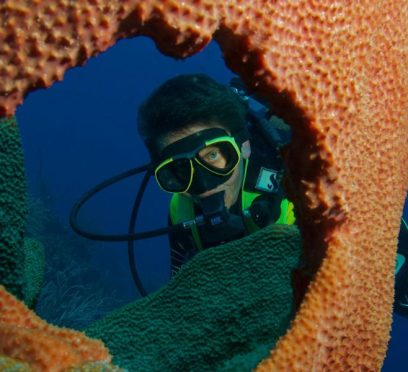
Grand Cayman Scuba Diving Guide: Explore World-Class Drop-offs & Marine Ecosystems
BY Sibashree Jun 25, 2026
The Cayman Islands are home to some of the greatest underwater scenes in the world and are considered the cradle of recreational diving. The water remains clear to a depth of 100 feet and is comfortably warm throughout the year, which is ideal for diving. Should you desire a comfortable yet thrilling holiday, making The Reef Beach Resort your home-away-from-home will be a wise decision. This resort offers you the possibility to dive or snorkel right out of your room to magnificent coral gardens, dramatic underwater cliffs, and shallow reefs full of sea creatures. That is why the place is equally good for new divers as well as diving veterans. Grand Cayman is the perfect place to try snorkeling or diving. Aside from excellent dive shops, there are friendly local guides, and one of the most stringently protected marine parks in the Grand Cayman Diving experience! With a little boating or even just swimming from a sandy beach, it is quite easy to spot sea turtles, eagle rays with spots, and stunning corals. The Geography Of Grand Cayman Diving: Three Distinct Coasts Grand Cayman is a special place, and one of the reasons it is so special is the distinctive underwater topography. The seabed plummets to very great depths just a short distance from the shore. Due to this arrangement, the island brings three different types of diving experiences to the northern, western, and eastern parts of the island. It is advisable for you to get familiar with these three locations well ahead of your arrival. Then you will be able to schedule your daily excursions based on your proficiency level and the marine creatures you want to observe. 1. The Legendary West Coast The west side of the Grand Cayman Diving is famous for its mirror-calm sea surface. In addition, divers enjoy very easy water entry here. Because the island blocks heavy trade winds, this area features shallow, sunlit reefs. These structures slope gently into deeper water. In this zone, you will find historic shipwrecks alongside shallow coral gardens teeming with tiny macro life. For this reason, most divers choose the west coast for two-tank morning trips, scuba refresher courses, and night dives. 2. The Dramatic North Wall Advanced divers who seek awe-inspiring views must visit the North Wall. In this area, the shallow underwater shelf suddenly ends. Then, vertical cliffs drop straight down into thousands of feet of deep blue water. The sheer scale of these drop-offs will take your breath away. During your dive, you will find massive deep-water sea fans and intricate swim-throughs. Furthermore, open-ocean predators like reef sharks and spotted eagle rays frequently cruise right past the deep, empty space. 3. The Pristine East End The windward side of Grand Cayman is rugged and wild. Because it sees far fewer tourists, it is perfect for divers who want a true sense of discovery. Open-ocean currents hit this side directly. Consequently, the East End features incredibly healthy coral formations, deep canyons, and winding tunnels. This high-energy environment also brings frequent encounters with larger marine life. Above all, the visibility here is often the best on the island, so you get to see pristine underwater views that remain completely untouched. Iconic Dive Sites You Cannot Miss Apst for Grand Cayman Diving, there’s so much more! Across the three islands, authorities have officially named 365 dive sites. Therefore, you could visit a new spot every single day of the year. However, a few world-famous locations belong on every diver's bucket list: Stingray City: This world-famous site features a shallow sandbar. Here, divers and snorkelers can stand or kneel in just 12 feet of water. Dozens of friendly southern stingrays glide all around your body. Therefore, it creates an interactive marine experience that works perfectly for families and photographers. USS Kittiwake Wreck: In 2011, the crew members deliberately sank this 251-foot submarine rescue ship to form a manmade reef. Nowadays, the ship is positioned in about 60 feet of water close to Seven Mile Beach. The highest part of the ship is almost at the water's surface. So, open-water divers are able to safely swim through the huge engine rooms, the steering bridge, and the decompression chambers. Babylon: This site is located on the East End. In fact, many experts consider Babylon the single best wall dive in Grand Cayman. Snorkelers can easily view the shallow reef at the top of the drop-off. Meanwhile, scuba divers can descend alongside a massive coral pinnacle that stands apart from the main wall. This path showcases cascading black corals, purple sea plumes, and crevices where green moray eels hide. Eden Rock & Devil’s Grotto: These sites sit just minutes from George Town. Because of their location, you can swim to them straight from the shore. They feature a massive maze of: Shallow coral caves. Tunnels. Grottoes. During the summer months, millions of tiny silverside fish fill these dark chambers. This movement creates a spectacular light show while large tarpon hunt through the schools. The Structural Health Of Cayman’s Marine Ecosystem Want to know about the Grand Cayman Diving quality and health? The exceptional diving quality in Grand Cayman did not happen by accident. Instead, it is the direct result of decades of proactive environmental action and strict conservation laws. The Department of Environment established a vast network of Marine Protected Areas (MPAs) across the islands. For example, local laws prohibit boats from dropping anchors on live coral beds. Instead, officials provide permanent mooring buoys for dive boats. Strict regulations also protect sea turtles, groupers, and sharks to maintain a natural ecological balance. In addition, dive instructors teach visitors to never touch anything underwater. This rule successfully protects: fragile elkhorn, staghorn, brain coral colonies. These organisms serve as the primary structural skeleton for these vital marine ecosystems. Preparing For Your Cayman Dive Excursion You should keep a few practical travel tips in mind before you go. By doing so, you will ensure your underwater trip stays safe, stress-free, and seamless: Bring Your Credentials: Pack your physical or digital dive certification cards from agencies like: PADI, NAUI, SSI. Do not forget your logbook to verify your recent dive history. If you have not logged a dive in the last 12 to 24 months, you should book a brief, guided refresher course in a pool. Coordinate Logistics: Check boat schedules, available rental gear sizes, and specialized training packages ahead of time. When you review the full plan directly, you can easily select the perfect reef or wall trips for your vacation days. Pack Reef-Safe Sunscreen: Protect fragile coral structures from harmful bleaching chemicals. To do this, buy mineral-based sunscreens made with zinc oxide or titanium dioxide for your beach and boat days. Execute with Confidence: Arrive early at the boat dock and listen closely to the safety briefing from your local divemasters. Next, check your tank's air gauge. Finally, take a giant stride into the warm water to explore the island's incredible drop-offs. Dive Into An Unforgettable Aquatic Adventure Grand Cayman is all about an unmatchable underwater holiday! It doesn't even matter whether you are looking to dive down sheer walls deeply, discover old shipwrecks, or freely float over brightly illuminated coral gardens. The secret of this island lies in a rare mix of serene waters, extremely good visibility, and a wide variety of marine life that makes it a prime destination in the world without anyone else being able to reproduce it. Getting away from the hecticness of everyday life is the right thing to do, so you should opt for a professional diving tour next time you go on a vacation. This helps you experience absolute weightlessness in a vibrant, deep-blue sea. Besides, engaging a competent diving operator will make sure that your trip to the most hidden reefs of the island is safe. Travel with local guides who have intimate knowledge of the animals' migrations as well as the slight changes in the tides. Ultimately, these arrangements make sure that not a single dive is compromised for safety, is unforgettable, and is stunning at the same time. Read Also: Things To Do In Utah For Once In A Lifetime Experience: The Ultimate Bucket List For You Raja Ampat Diving Season Tips: When To Go For Mantas, Whales, And Sunshine? What Are The Best Raja Ampat Diving Trips? Know The Sites And Practical Tips How To Do Raja Ampat Budget Diving: The Ultimate Cost Breakdown For 2026
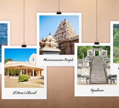
Why Is Puttalam Sri Lanka Famous? What Are The Things To Do In Puttalam?
BY Sibashree Jun 24, 2026
Puttalam grabbed everyone’s attention with the sudden visibility of a mysterious object with a length of several feet in the sky. There were speculations about the object being a missile, rocket, or meteor shower. A few months ago, on 15th December, 2025, the Geminid meteor shower was clearly visible in the sky. However, these are not one-off instances. I could clearly see the Milky Way in Puttalam Sri Lanka, in the month of April. Furthermore, the wilderness surroundings, remote areas such as Eluwankulama, and a relatively flat topography on the southwestern coast, make Puttalam one of the chosen places of stargazing in Sri Lanka. But beyond the stargazing excitements, Puttalam, Sri Lanka, bears a rich history, exudes serene coastal beauty, and has a colonial heritage. In this article, I will talk about my days in Puttalam so that you know that coastal beauty better. Where Is Puttalam? Known for massive coconut production, prawn farming, and salt production, Puttalam town is the capital of the Puttalam district. It is on the shore of the Puttalam lagoon, the second largest lagoon in the country. The International Union for Conservation of Nature (IUCN) is now encouraging the most sustainable use of the lagoon resources. Thus, they are supporting the exploration of new ecosystems here for better fisheries management. Here is an excerpt from a report published by IUCN on 4th April, 2025. “With 88 fishing villages and approximately 165,000 people dependent on it, fisheries in Puttalam have been identified by its residents as their most important ecosystem service, particularly for women, who participate in bivalve gleaning and other post-harvest livelihoods. The lagoon is an important area for endangered species, such as green sea turtles and dolphins, and contains ecosystems vital for its health, such as seagrass and mangroves. Tourism is also important in the Lagoon, which hosts seasonal aquatic sports and has year-round visitors to its islands. The islands additionally have cultural importance as they are connected to local religious values.” Moreover, Puttalam has the Indian Ocean on the west, and it is the gateway to the Kalpitiya peninsula and Wilpattu National Park. How To Reach Puttalam Sri Lanka? Puttam is located around 130 km north of Colombo. It is also located at a distance of close to 95 km from Nogombo. Furthermore, it is well-connected to Colombo and other major cities/hubs of the country through the Puttalam Railway Line and A3, A10, and A12 highways. By Train The train travel from Colombo Fort to Puttalam takes between 3 hours and 45 minutes and 5 hours. Moreover, the ticket price will be between LKR 250 and LKR 1550 (Source: the Department of Railways. Sri Lanka. By Bus Also, you can take a bus from the Bastian Mawatha Bus Terminal in Colombo and travel to Puttalam with a stopover in Anuradhapura. You can even take the direct 87/816 buses. They cover the distance within around 4 to 4.5 hours, and the regular, non-AC bus tickets cost between LKR 500 and LKR 800. What Is The History Of Puttalam Sri Lanka? Puttalam in Sri Lanka today stands out with its multicultural identity. Here, you will find a fusion of Sinhalese, Sri Lankan Moors, and Tamil cultures, which have lived for generations. Furthermore, as a commercial and administrative center, it supports diverse activities such as prawn farming, shallow sea fishing, and salt production. However, this town on the northwestern coast of Sri Lanka has a history spanning 10000 years. Located on the large Puttalam Lagoon, it has been a maritime trade hub, a center for the colonial spice and coconut industries, and has an enduring and culturally diverse population. Here, I have broken the history of this coastal town into three sections. Ancient Roots And Indigenous Beginnings The archaeological evidence of the locality shows that human settlements started here 75000-125000 years ago. Prince Vijaya, 6th century B.C., chose it as the landing site, and thus the Sinhalese lineage started here. Medieval Trade And Arab Influence During the medieval period, Puttalam became a major location for maritime trade. Arab merchants, who established deep roots in the region, laid the foundation for the prominent Moorish population in the area. Furthermore, the name Puttalam comes from the Tamil word Puthu-kulam. Puthu-kulam means "new tank" or "new pond.” Thus, it indicated the vital irrigation tanks that sustained early agricultural settlements. The Colonial Era Many European powers wanted to control the lucrative trade routes of Puttalam because of its natural resources and coastal position. The Potuguese was the forest to build a built a strategic fort in Puttalam to secure the region and monitor trade in the 16th century. Then, in the 17th and 18th centuries, the Dutch came. They captured and significantly expanded the Portuguese fortress. Furthermore, during these times, Puttalam became a central transit point for the highly profitable cinnamon trade and salt production within the lagoon. In addition, in the 19th and 20th centuries, the British came to power. They used the fertile soil of the region for the expansion of the coconut industry. Thus, Puttalam became one of the most critical sources of copra and coconut products in the island. A Quick Summary Of The History Of Puttalam Era/PeriodKey Historical Developments and MilestonesOver 10,000 years agoEarly human settlements established, supported by archaeological evidence.Medieval Period- Puttalam became a pivotal west-coast maritime trade hub.- Arab merchants settled, forming the roots of the Sri Lankan Moor community.- Named Puthu-kulam ("new tank/pond") after vital local irrigation tanks.Portuguese Rule(16th Century)A strategic coastal fort was constructed to monitor trade and secure the region.Dutch Rule (17th and 18th Centuries)- Captured and expanded the Portuguese fortress.- Transformed the town into a transit hub for cinnamon and lagoon salt production.British Rule (19th and 20th Centuries)- Developed agricultural infrastructure.- Oversaw rapid expansion of the coconut industry, making it a top source for copra. Why Is Puttalam Famous? Puttalam is famous for its historical ruins, religious centers, and natural attractions. You cannot miss the following attractions. 1. Munneswaram Hindu Temple The Munneswaram Hindu Temple is one of the five historic coastal temples of Lord Shiva in Sri Lanka. The history of the temple goes back to at least 1000 CE. Moreover, it is associated with the stories of the Ramayana. Also, it is a unique spiritual hub where Buddhists and Hindus unite. 2. St Anne’s Church St. Anne’s Church is along the coastline of Thalawila. It has a peaceful ambiance. Also, it dates back to the Portuguese era. It serves as a monumental pilgrimage site. Furthermore, it draws hundreds of thousands of believers from across the island for its grand annual feast in July. 3. Alankuda Beach The Alankuda Beach has a tranquil stretch of golden sand, and it is known for dolphin and whale watching excursions. Located in Kalpitiya, it is a premier eco-tourism destination, highly favored by adventure travelers for thrilling water sports like kitesurfing and windsurfing. 4. Hatthikuchchi Viharaya Tucked away in a peaceful forest landscape, this 3rd-century BCE Buddhist monastic complex is famous for a massive rock formation that resembles an elephant's stomach. It is highly revered as the legendary sanctuary where the pious, exiled King Sirisangabo self-sacrificially gave up his own head to assist a poor peasant. 5. Anawilundawa Wetland Sanctuary This Ramsar-designated site is an important landmark for ecotourism in Sri Lanka. It has a historic human-made system of interconnected freshwater tanks crashing right against a coastal lagoon. Furthermore, it is an irreplaceable, thriving sanctuary for thousands of native and migratory birds. 6. Puttalam Lagoon The Puttalam Lagoon, spanning an area of 32,700 hectares, is the second-largest backwater body in the country. It has calm waters, and it is an ideal hub for small-scale prawn harvesting, wildlife viewing, and kite surfing. 7. Puttalam Station The colonial rulers of Puttalam opened the railway station officially on 12th May 1926. Today, it is a state-run railway station and attracts many visitors due to its colonial charm and surrounding scenic beauty. 8. Yapahuwa Built by King Buwanekabahu, Yapahuwa was the royal residence in the 13th century. Today, you will get to see the remains of this royal palace. I was especially mesmerized to see the ornate staircase. 9. Chilaw Chilaw, located a few kilometers south of Puttalam, is a small town that stands out because of its religious harmony. People from various traditions, backgrounds, and religions live here. Furthermore, the beach here offers a calm and relaxing ambiance and the fishing villages here give you insights into the local way of living life. What Are The Things To Do In Puttalam? While Puttalam has the most tranquil vibe, it is also the hub of most adventurous activities, such as kite surfing, bar reef snorkeling, and wildlife safaris. 1. Kite Surfing In Kalpitiya Kalpitiya is a global kite surfing hub. It has consistent wind conditions for over nine months of the year. Furthermore, the flat-water lagoons here offer a safe space for learning. On the other hand, the ocean waves here challenge the advanced riders. Also, the Margarita Kite School is the best name in kite surfing training in Kalpitiya today. It trains tourists and locals with the latest equipment. Moreover, the downwind trips here are epic. You can glide across pristine, uninhabited islands and sandbars dotting the massive lagoon. 2. Dolphin Watching I could spot hundreds of playful dolphins gathering in spectacular groups just off the Kalpitiya coast. November to April is the best season to spot these adorable animals as the water remains calm. Also, local guides follow strict conservation guidelines to protect the natural habitat of mammals. So, you have to follow responsible tourism practices. 3. Diving Puttalam has a diverse marine life. So, you can explore vibrant ecosystems teeming with sea turtles, reef sharks, and manta rays. It also has historic shipwreck sites where fascinating sunken vessels are wrapped in colorful soft coral colonies. Furthermore, warm waters offer crystal-clear viewing conditions during the calm winter diving months. In addition, when you descend along deep underwater cliffs that host a spectacular variety of macro life. 4. Wildlife Safari At Wilpattu National Park The Wilpattu National Park has villus or natural rainwater lakes. It is famous for its high density of leopard population. Furthermore, here, you can spot elusive sloth bears, wild elephants, crocodiles, and colorful endemic jungle birds. So, the jeep tour on the rugged off-road tracks was immersive. It cost me around LKR 16000. 5. Bar Reef Snorkeling Here, you will find the most beautiful coral sanctuary of Sri Lanka. Also, here, you can swim alongside brightly colored butterflyfish, giant parrotfish, and harmless blacktip reef sharks. Furthermore, you will marvel at delicate, healthy formations of brain and staghorn corals just below the surface. In addition, you can take short boat rides from the mainland to reach these shallow swimming areas. What Is The Best Time To Visit Puttalam Sri Lanka? January to March and May to September are the best times to visit Puttalam. The dry and sunny weather conditions in the month are ideal for coastal kitesurfing in Kalpitiya, whale watching, and leopard safaris in the nearby Wilpattu National Park.
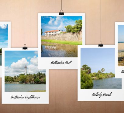
What Is Batticaloa Famous For? Know The Best Things To Do In This Eastern Town Of Sri Lanka
BY Sibashree Jun 24, 2026


