


Desert Terrain Makes Preparation Part Of A Better Las Vegas ATV Experience
BY Sibashree Jul 16, 2026
Las Vegas is often associated with bright lights, crowded casinos, and indoor entertainment. Outside the Strip, however, the landscape changes quickly. There, you come across certain geographical factors that are quite challenging, such as: Dry Washes Rocky Trails Open Desert Steep Terrain These create an exciting setting for an off-road excursion. But they also make preparation essential. Therefore, a little planning helps travelers enhance their Las Vegas ATV Experience. Also, they will spend less time managing discomfort and more time enjoying the ride. Whether you are organizing an outing for friends, planning a family vacation, or arranging an employee activity, the best desert experience starts before you reach the trailhead. Best Practices To Enhance Your Las Vegas ATV Experience These are the top three practices that will help you make the most out of your experience. 1. Match The Ride To Your Group ATV excursions are not one-size-fits-all. A first-time rider may need a different pace and vehicle setup than someone who regularly spends weekends on off-road trails. Before booking, consider the age and comfort level with uneven terrain of everyone in the group. In addition, you must consider factors such as their riding experience and fitness levels. If your party includes beginners, look for an outfitter that provides clear instruction and a guided route. A professional guide can explain to you certain basics of the rides, such as: Throttle Control Braking Turning Moreover, they will give you a clear picture of spacing between vehicles before the ride begins. This instruction is especially valuable in desert terrain, where loose gravel, sudden dips, and narrow paths can make simple maneuvers feel unfamiliar. Review the company’s requirements in advance. Some operators have minimum age or height rules, require a valid driver’s license, or limit passengers based on the vehicle type. Confirming those details before your trip can prevent an expensive or disappointing change of plans. For visitors comparing local options, ATV Las Vegas can serve as a starting point for researching guided desert rides and planning around the group’s experience level. 2. Prepare For Heat, Dust, And Uneven Ground Desert conditions can be demanding even when the air feels comfortable at the beginning of the day. As we all know, temperatures rise quickly under direct sun. Then, riding adds physical exertion. During summer, an afternoon outing may be considerably more tiring than a morning departure. In cooler months, early starts can bring chilly air before the sun reaches its peak. Therefore, you need to wear lightweight, breathable clothing. This will help you cover the arms and legs. Long pants help protect against dust, brush, and minor scrapes, while a breathable long-sleeved shirt can reduce sun exposure. Closed-toe shoes with a secure fit are more practical than sandals or loose footwear. Eye protection is another small detail with a major effect on comfort. Dust and grit can become irritating when several vehicles travel along the same route. Many guided excursions provide helmets and protective equipment, but it is worth asking what is included before arriving. Sunglasses or clear protective eyewear may also be useful, depending on the operator’s recommendations. Bring water and use sunscreen before the ride starts. Reapply sunscreen if the excursion lasts several hours, especially on the face, neck, and hands. A hat may help before or after the ride, although it generally will not fit under a helmet. 3. Plan Around Safety And Timing The desert is remote in ways that may not be obvious from Las Vegas hotels. Cell service can be limited, weather can change quickly, and a minor problem can become more serious when a group is unprepared. Follow the guide’s instructions, maintain the recommended distance, and avoid pushing beyond your skill level to keep up with more experienced riders. Check the forecast for high winds, extreme heat, or possible storms. Heavy rain can create flash-flood conditions in desert washes, even when the sky above the city appears clear. A reputable operator may adjust or postpone a route when conditions create unnecessary risk. Build extra time into the day. Transportation, check-in, safety briefings, equipment fitting, and return travel can take longer than expected. Rushing from a hotel, airport, or another attraction can cause people to arrive without enough water, proper clothing, or time to listen carefully to the orientation. Mistakes To Avoid For A Protected Las Vegas Atv Experience To make the most of your Las Vegas ATV adventure, avoid rookie mistakes like skipping eye protection, wearing the wrong clothes, and underestimating the desert heat. • Skipping Eye Protection Desert riding kicks up massive amounts of dust and rocks. Therefore, you must ensure taht you are always wearing snug-fitting off-road goggles. This will be a much more appropriate option than regular sunglasses. • Wearing Open-Toed Shoes And Shorts You will be maneuvering around a hot engine and riding through rocky terrain. So, it is a better option to protect yourself with over-the-ankle boots. In addition, you must wear durable pants and long sleeves. • Underestimating Hydration The Mojave Desert air strips moisture faster than you realize. Drink plenty of water the night before and bring a hydration pack on the trail. • Ignoring The Guide's Rules Tour guides set specific paces and hand signals to keep the group safe. Trying to pass others or break formation is a safety hazard that can get you booted from the tour. • Booking At The Wrong Time Of Day You must avoid riding during peak midday heat in the summer months. Additionally, it is better to opt for early morning or sunset tours for a much more comfortable climate. • Improper Body Positioning When taking sharp turns or going up steep inclines, shift your weight correctly rather than keeping it dead center. This will help prevent the vehicle from becoming unstable Make The Las Vegas ATV Experience Work For Everyone The strongest group outings balance excitement with comfort. Schedule the ride when participants are most alert. Additionally, you must allow time for meals and hydration. Also, you need to avoid placing a demanding excursion immediately after a late night or long travel day. If someone has a medical concern, injury, or limited mobility, address it with the operator before booking rather than making assumptions at the trailhead. Preparation does not take away from the adventure. It allows riders to focus on the scenery, the changing terrain, and the shared experience. In the Las Vegas desert, thoughtful planning is what turns an ordinary excursion into a safer, more enjoyable day outdoors. Read Also: Travel Considerations For Out-Of-Town Facial Plastic Surgery Patients How To Pack Light For Any Trip: 10 Essentials Every Traveler Needs Common Mistakes Travellers Make Before International Flights
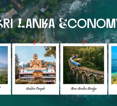
Sri Lanka Economy 2026 Hits A Different Milestone: The Tourism Sector Is Simultaneously Chasing A “Value Over Volume”
BY Sibashree Jul 16, 2026
A Quick ViewAfter the July 2026 reclassification of the World Bank, Sri Lanka has become an upper-middle-income economy. The reclassification has happened as a result of a 5% GDP rebound driven by tourism, industry, and finance, three years after its 2022 debt default.Especially tourism has hit record arrivals in 2025 (2.36 million), though revenue and per-visitor spending still trail 2018 levels.Also, authorities are targeting $4 billion in 2026 tourism revenue through a "value over volume" strategy.However, the recovery narrative remains complicated with IMF debt-risk warnings, inflation, and a Middle East crisis. A Story of Recovery! This is what the World Bank has called the upgrade of the Sri Lankan economy in 2026. Overcoming the deep economic crisis in 2022, it is now an upper-middle-income economy. But what does it mean for the tourism landscape of the island country? After traveling to Sri Lanka many times, I am curious to know whether it indicates rebranding and a paradigm shift. The answer is a thumping YES, and tourism has been a major force behind the economic expansion of 5% (GDP Growth) in Sri Lanka in 2025. So, here is a deep dive into how Sri Lanka economy 2026 is going to impact the country’s tourism. What The World Bank Classification Of Sri Lanka Economy 2026 Actually Measures World Bank moved Sri Lanka from lower-middle to upper-middle income on July 1, 2026, based on 2025 GNI per capita data, alongside Jordan, the Philippines, Vietnam, and Micronesia. The upper-middle band runs roughly $4,516–$14,005 GNI per capita, and Sri Lanka crossed the threshold narrowly with a GNI of $4,670 in 2025. So, there are two takeaways from the reclassification. First of all, "upper-middle income" is a technical designation. It does not describe the household living standards. Secondly, there has been a lot of overstatement about the reclassification. However, as mentioned, Sri Lanka has just crossed the threshold. It is not a transformation, and the country could plausibly sit near the boundary for several classification cycles depending on GNI growth, exchange-rate movements, and population changes. Again, the World Bank has used the Atlas method, which smooths out exchange-rate volatility. In this method, the World Bank has divided economics into four bands. Low-Income Lower-Middle Income Upper-Middle Income High Income This recent update has covered 218 economies and will remain the reference classification until June 30, 2027. So, while it is a significant marker for a country that was rationing fuel, running double-digit inflation, and defaulting on its external debt just four years earlier, the economic story has more layers to it. Sri Lanka Is Not A First-Time Entrant To This Category There is a third aspect to talk about when we discuss the reclassification of the Sri Lankan economy. Sri Lanka has not moved to this level for the first time. It used to enjoy the same status before 2022, after which the crisis knocked the economy back down to lower-middle income. So, this is like regaining a previously lost ground instead of achieving a brand new milestone. Also, there are the practical consequences of this upgrade. It plays a role in determining a country's eligibility for concessional financing and development assistance, meaning Sri Lanka's terms of access to certain low-cost loans may shift as a result of the upgrade. The Recovery Story Behind The Upgrade The story behind the reclassification of Sri Lanka economy 2026 is different from that of Vietnam or the Philippines. The World Bank itself clarifies that Vietnam's upgrade reflects a decade of export-led expansion. On the other hand, the Philippines reflects broad-based growth across nearly every sector. However, the reclassification of the Sri Lankan economy is a resilient narrative following a severe crisis. The numbers vouch for this claim. Just three years back, in 2022, the country faced a crisis that almost brought it to the brink of collapse. However, in 2025, the real GDP expands by 5%. Industrial activities alongside growth in the financial and tourism sectors have propelled this growth. Also, the crisis in 2022 is worth remembering as it was the first sovereign default of the country in its post-independence history. It happened due to a foreign exchange collapse that led to fuel and medicine shortages nationwide. The IMF Stepped In The International Monetary Fund (IMF) offered an Extended Fund Facility program in March 2023. At that time, the country's foreign reserves were $1.9 billion, and the LKR had lost half of its value. Furthermore, in a recent press release published on 27th May 2026, the IMF has confirmed that it has “...completed the combined Fifth and Sixth Reviews of the Extended Fund Facility for Sri Lanka, providing the country with immediate access to SDR508 million (about US$695 million) to support economic policies and reforms” In the same press release, the IMF has again mentioned that the total program payout now stands at around $2.4 billion. In addition, in the IMF Country Report No. 26/111, we can see that the fiscal performance of Sri Lanka has improved. The tax revenue in 2025 reached 15.4, which was a sharp rise from the tax revenue figure of 9.9 in 2023. In addition, the primary budget surplus exceeded 5% of GDP in 2025, ahead of program targets. So, overall, it is a faithful macroeconomic progress. However, it does not mean absolute stability or the Sri Lankan economy being completely risk-free. A Snapshot Of Sri Lanka’s Economy Since 2022 Here is a summary of the key changes in the economy of Sri Lanka from 2022 to 2026. (Sources: World Bank, IMF, Sri Lanka Tourism Development Authority (SLTDA), World Bank, and Sunday Times). Indicator2022 (Crisis Low)2023202420252026World Bank income classificationLower-middle incomeLower-middle incomeLower-middle incomeLower-middle incomeUpper-middle income (from July 1)Real GDP Growth Deep contraction-2.3% Contraction (Stabilized by mid-year after the 2022 crash)5% Growth5% GrowthModerating with inflation shock mid-yearForeign reserves$1.9 billion$4.4 Billion$6.12 Billion$7 Billion (Estimated, March)$6.8 Billion (End of April)Tourist ArrivalsRecovering1.48 Million2.05 MillionA Record of 2.36 MillionA Target of 3 MillionTourism RevenueDepressed$2.0 Billion$3.17 Billion$3.2 BillionA Government Target of $4 BillionHeadline InflationVery High (Crisis)Returned to Single Digits. Averaged 16.5% annually, but dropped from a 60-70% peak down to 4% by Dec.Deflationary Period5% (Year-End)Spiked to 5.5% by May amid Energy Shock After sharing the financial summary, let’s talk about the tourism performance in 2025-26 and what the future looks like. The Actual Tourism Scene Of Sri Lanka In 2025-26 The tourism sector of Sri Lanka had a record year in 2025. However, when analyzing data from various sources, I found out that some structural challenges still remain, and an income reclassification cannot fix them directly. The Gap Between Tourist Arrival And Revenue The Sri Lanka Tourism Development Authority has confirmed an arrival of 2,364,978 tourists in 2025. It even broke the record of 2.33 million tourist arrivals in 2018. However, a Daily FT report published on 12th January 2026 clearly mentions that, revenue-wise, the year-on-year revenue growth in 2025 was just 1.6% despite a boost of 15% in tourist arrivals. In addition, the tourism revenue in December 2025 went down by 14.8% YoY ($ 308.6) despite a record set in tourist arrivals. The Tourist Spending Gap The tourist spending gap depicts the real story. The same Daily FT report I have earlier referred to has mentioned that the average daily tourist spend fell to about $148 in 2025. Industry analysis attributes much of this to the rapid growth of budget guesthouses and Airbnb-style listings. Amarasiri, a guesthouse owner and a friend I met during my trip to Sri Lanka, shared his opinion on this. “Most of these offer a pricing of under $50 a night, pulling the market average down against higher-end hotels charging $125–150.” In addition, the overall contribution of tourism to the GDP has also shrunk. It was 5% in 2018, and as of 2025, it stands at 3%. Does The Momentum Continue In 2026? The tourism industry of Sri Lanka had a great start in 2026. By the first quarter, the country already had over 740,000 visitors. February was the month when the numbers peaked. As a result, the tourism authorities had set a target of 3 million arrivals and $4 billion in tourism revenue for 2026. Furthermore, there was an explicit strategic shift toward high-value visitors rather than sheer volume. To support that shift, the Tourism Ministry again launched an eight-month global marketing campaign in April 2026, backed by roughly $6.4 million and targeting 12 to 15 source markets. These markets included India, the UK, Germany, China, and the Middle East. However, nobody anticipated the geopolitical shock in the Middle East. It caused a fall in tourist arrivals of around 20% in March on a YoY basis. Also, with current day-to-day proceedings, the numbers do not seem to go up before September 2026. The same conflict pushed up fuel costs sharply, and rupee-denominated Brent crude prices rose by more than half in about ten weeks in early 2026. Again, it disrupted flight routing, given that the Middle East accounts for roughly a third of flights into Sri Lanka. Does The Income Reclassification Actually Move The Needle For Tourism? Here is an honest assessment. The reclassification of Sri Lanka economy 2026 by the World Bank is not a policy lever for a direct transformation in the tourism sector. However, it is an intersection of the tourism and financial sectors in many concrete ways. 1. Investor And Lender Perception The reclassification as an upper-middle-income country can give positive signals in how international investors, hotel groups, and lenders assess country risk. Thus, it will improve the path for hospitality infrastructure investment. However, the reclassification does not override the more immediate signals investors watch. These signals are: Currency Stability Debt Sustainability Ratings The Trajectory of IMF Programs 2. Currency And Pricing Dynamics A stronger and more stable rupee indicates how affordable Sri Lanka feels to foreign visitors. Furthermore, currency stability was one of the explicit achievements cited in IMF program reviews. Though 2026's energy-driven inflation spike and the accompanying rate hike show that stability is not guaranteed and can reverse quickly under external shocks. 3. Financing Terms, Not Tourist Experience The most practical effect of the classification is on Sri Lanka's access to concessional financing. The reality is that upper-middle-income countries generally face different (often less favorable) borrowing terms than lower-middle-income ones. Now, this is a huge factor in determining the ability of the government to fund tourism infrastructure, including airports, roads, and utilities in emerging destinations. However, it is an indirect, medium-term channel rather than something a visitor booking a trip this year would notice. 4. Brand Narrative, Not Policy Change The most immediate effect of this reclassification is reputation. Economic recovery and upper-middle-income! Terms like this make for a more compelling destination narrative than "post-crisis" or "developing economy in distress." The tourism authority of Sri Lanka is already leaning into a comeback narrative in its 2026 marketing push. Now, the World Bank news gives that campaign an additional, credible data point to cite. What the classification does not do is directly address the structural issue tourism officials themselves have flagged. It is getting visitors to spend more per day. That's a product mix and marketing problem. It encourages MICE travel, weddings, wellness tourism, and higher-end stays that Sri Lanka is already tackling on its own terms, income classification or not. 5. Unlocking High-Value Tourism Niches The Wellness Boom: Wealthier economies pull health-conscious travelers looking for upscale, authentic Ayurvedic and holistic medical retreats. MICE Travel Magnet: Corporate infrastructure upgrades position Colombo as a highly competitive regional hub for Meetings, Incentives, Conferences, and Exhibitions (MICE). Niche Eco-Adventures: Enhanced funding speeds up the preservation of wildlife sanctuaries and marine parks, drawing premium sustainable-travel consumers. 6. Strategic Advantages Over Competitors The economic reclassification gives Sri Lanka a strategic advantage over its competitors. The table below explains the key areas. Metric / AspectSri LankaIndiaBali/IndonesiaWorld Bank StatusUpper-Middle IncomeLower-Middle IncomeUpper-Middle IncomeTourism FocusHigh-end wellness and boutiqueDiverse mass and culturalHigh-volume mixed leisureFDI AppealHigh (Fresh post-crisis rebound)High (Scale-driven infrastructure)Mature / Nearing saturationPer Capita FootprintLow volume, high expenditureHigh-volume varianceSevere over-tourism pressures 7. Supply-Side Infrastructure And Service Upgrades Institutional stability triggers major foreign direct investments. Mega ventures such as the $850 million City of Dreams integrated resort in Colombo are one of the most prominent examples of it. Furthermore, with a rising per capita income, there is an empowerment of businesses to invest heavily in formal hospitality training. As a result, the workforce skill gaps are eliminated. Moreover, a greater fiscal boom allows the country to fund critical tourist amenities. These include smoother highway connectivity to expanding green and renewable energy grids for eco-tourism. For example, the Global Environment Facility (GEF) and IUCN are working together to protect the central highlands of Sri Lanka. They are working to protect the biodiversity and improve the livelihood of the people in this area. GEF is supporting this initiative with funding of 3.5 million USD. However, with these initiatives already ongoing, you may question what the reclassification can actually bring to the table. Why Does The Recovery Remain Fragile? The story of revival for the economy of Sri Lanka focuses on human resilience. Now, if you think I am not giving the reclassification its due credit, I have my concern areas to justify it. High Debt And Sustainability Risks The IMF's own debt sustainability framework rates Sri Lanka's overall risk as high. Furthermore, Fund staff have acknowledged that even after a successful program and a near-complete debt restructuring, sustainability risks are expected to persist for years. Also, external debt can become more demanding as early as restructured bilateral and commercial debt matures alongside IMF repayments. In addition, the current IMF Program will expire in March 2027. Thus, despite the reclassification, there is a narrow window to build reserves and sustain the reforms already made. Dependency On Official Sector Support The return of Sri Lanka to the international capital markets is yet to happen. Furthermore, the country has not built reserves to the program's target threshold. These show how the country is dependent on official-sector support rather than standing fully on its own. Furthermore, late 2025 and the year 2026 so far have brought two external shocks. 1. Cyclone Ditwah Struck in Late 2025 It has called for an emergency IMF financing and a supplementary government budget for relief and reconstruction. 2. Middle East conflict The Middle East conflict has caused a hike in fuel prices, problematic remittances, and disrupted flight connectivity through the first half of 2026. Trade Policy Adding Another Layer Of Uncertainty Sri Lankan economy also faces uncertainty due to its trade policy, Sri Lanka is currently facing an effective US tariff rate of around 20% under Section 122 measures. Furthermore, its preferential GSP+ access to the EU market is set to expire in 2026, with authorities planning to reapply under a revised framework. None of this directly targets tourism, but it affects the broader currency and investment environment that shapes how affordable and accessible the country feels to international travelers. So, What Does The Reclassification Actually Mean For Travelers? The Practical Takeaways For us, the global travelers and global travel writers, the practical takeaways are more modest and specific than the headlines suggest. Trend / Strategy ComponentKey Insights and DetailsStrategic Focus / ImpactPricing and Market PositionPrices will drift upward gradually, narrowing the gap for mid-range and upmarket properties."Value over volume" strategy, as budget travelers will see higher costs due to post-2026 inflation.Target Source MarketsCourtship of new markets (Poland, Eastern Europe) alongside traditional ones (India, UK, Germany).Diversifying and expanding future arrivals growth.Growth SegmentsHigh focus on MICE (Meetings, Incentives, Conferences, Exhibitions), weddings, and wellness travel.Driving higher per-visitor spend across the sector.Risk FactorsVulnerability to external events like Cyclone Ditwah and Middle East conflicts.Tourism numbers swing sharply based on geopolitical and weather risks, not just domestic policy. The actual challenge of the tourism sector remains in converting the record visitor numbers into a kind of high-value, high-spend visits that generate the expected revenue growth. The income upgrade may support that ambition indirectly, through investor confidence and destination narrative. However, the short-term fortunes of the sector will likely be shaped far more by currency stability, fuel prices, and regional geopolitics. Also, the outcome of Sri Lanka's IMF program through its March 2027 conclusion will be a more important factor than the income bracket in which the World Bank places the country.
What Is Special In Hikkaduwa? Uncovering What Is Great, Okay, And Ugly In This Sri Lankan Resort Town
BY Sibashree Jul 13, 2026
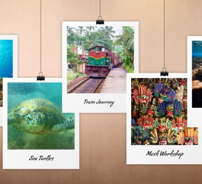
During my trip to Sri Lanka, Hikkaduwa, the resort town, was surely one of the biggest highlights of the southwestern region. I took a train journey from Colombo to reach Hikkaduwa, the epicenter of dark tourism in Sri Lanka. It was the place where the 2004 Boxing Day Tsunami had hit the most! However, while this keeps the mood somber and humbling while visiting Hikkaduwa, the town also offers some delightful experiences. It is a hotspot for scuba diving and turtle spotting like other southwestern beach destinations, such as Mirissa Beach, Bentota Beach, Unawatuna, and Ahangama and Weligama. Despite so many attractions, this resort town is now facing a serious dip in its tourism industry due to the US-Iran conflicts. A report published by The Island Online on 13th May 2026 suggested that there has been a drop of around 80% in tourist arrivals due to this ongoing global tension. While I wish for the end of the war and the global crisis (including the conditions in Hikkaduwa) soon, here I pen down my experience in Hikkaduwa. I loved a lot of things about it and also felt some things could have been better. So, here is an honest confession. The Things I Loved Doing In Hikkaduwa Hikkaduwa is not an idyllic tropical escape. It is an action-packed beach destination for snorkeling, scuba diving, and swimming with the adorable turtles. Hikkaduwa also has the Tsunami Museum, which is a must-visit to learn about the calamity that changed the course of the human race. Also, it shows the resilience of the human race in surviving such a rampage. Nevertheless, here are the best things to do in Hikkaduwa. 1. The Train Journey From Colombo To Hikkaduwa The journey in a third-class train from Colombo Fort to Hikkaduwa had set the mood right for the delightful experiences ahead. The distance of 95.14 km by train took around 2 hours to cover. The compartment was windy, and I also got a seat for myself. However, once the train started running, I stood close to the door, and the views of the Indian Ocean were iconic. The third-class ticket cost me LKR 200. However, if you are traveling in second-class and first-class compartments, the ticket price will be LKR 400 and LKR 800, respectively. 2. Spotting The Sea Turtles In Hikkaduwa The adorable sea turtles were the reason behind my visiting Hikkaduwa. I visited the turtle hatchery first, where I found 3-day-old turtles swimming. Then, I went down the beach to find them on seagrass. The Sea Turtle Hatchery & Rescue Center in Hikkaduwa remains open from 9 AM to 6 PM. Furthermore, the ticket price was 2000 LKR for foreigners and LKR 500 for locals. April to July is the best time to spot these turtles as it is their nesting season. Also, if you want to spot them on the beach, be present in front of Hikka Tranz at dawn. 3. Exploring The Coral Reefs At Hikkaduwa You will find the coral reef of Hikkaduwa just in front of the main hotel strip. So, you can spot them by just walking off the beach. You can also snorkel to explore the reef. Also, there are delightful provisions for taking a glass boat tour. These tours cost between LKR 3000 and LKR 6000 based on the duration of 30 minutes to 1 hour. Furthermore, the Hikkaduwa coral reef is a shallow fringing reef with an average depth of 1 to 5 meters, harboring over 60 species of hard coral and 170 species of reef fish. Moreover, it has the designation of a marine national park, and it is home to green and hawksbill sea turtles and other adorable marine animals. 4. A Visit To The Ambalangoda Mask Workshop And Museum Hikkaduwa was again an eye-opener, showing the cultural richness of Sri Lanka. I have cherished the Tamil Culture in Jaffna, and of course, Kandy was like the textbook. Hikkaduwa, on the other hand, made me familiar with the popular demons in Sri Lankan folklore. Maha Sona was the most powerful among them, and Reeri Yakseya was the most cruel. Also, there are other demons associated with various disorders. It is said that these disorders can be cured only by exorcism. The exorcists wear different masks of demons and dance to the drum beats. They also make offerings to the demons. They believe that the demons will leave the one they have attacked if they are happy with the offerings. The Ambalangoda Mask Workshop and Museum has a brilliant display of these masks. It is the cradle of Sri Lankan mask making, and the Wijesuriya family has been in charge of the museum for five generations now. The museum also has a library and workshop, where seeing the art of mask making was quite an experience. Moreover, the museum remains open from 8:30 AM to 5:30 PM, and entry is free. 5. Shopping In Hikkaduwa The Hikkaduwa Market was delightful. For me, the best buy was a shell turtle statue. Furthermore, many shops had colorful masks, and each of them was unique. During shopping, I also had the chance of meeting the locals in Hikkaduwa. I especially cherished the conversations with an old gemstone shop owner. He shared how he has been witnessing the changing tourism scenario in this resort town. 6. Scuba Diving Scuba diving is one of the biggest attractions in Hikkaduwa for sure. It is a delightful experience to go deep into the water and spot the marine life. However, I loved diving to find out the mast and rigging of an old sailing ship. 7. River Tours I traveled around 50 minutes from Hikkaduwa for a boat tour on the Madu Ganga River. It is in a Ramsar wetland and estuary on the southwest coast of Sri Lanka, located in Balapitiya. The boat took us through a narrow tunnel with mangroves on both sides. During the journey, we could spot vampire bats, crocodiles, and giant lizards. Furthermore, the 2-hour boat tour cost me around LKR 6000 to 15000. While the mangrove tunnels were the first stop, we also visited the Cinnamon Island and enjoyed a fish therapy in an enclosed pool for LKR 900. Moreover, visiting the Kothduwa Purana Raja Maha Viharaya was a unique cultural experience. Do not forget to bring binoculars for these boat tours, as there is a lot to see from a distance. 8. Visiting The Hikkaduwa Tsunami Museum The Tsunami on 26th December 2004 was one of the biggest natural disasters in Hikkaduwa and other parts of the eastern and southern coasts of Sri Lanka. The death toll was 30,196, and the waves engulfed the “Queen of the Sea” holiday train with 1700 passengers inside. The site now has a giant Buddha Statue as a symbol of peace. Many locals visit this statue and the Tsunami Honganji Viharaya, a place of worship to remember their loved ones who have lost their lives in the tsunami. After visiting the Tsunami Honganji Viharaya, I headed toward the museum. The museum explains the geographical process of how the tsunami happened and how Hikkaduwa survived after that. Entry to the museum is free, and it remains open from 8 AM to 8 PM. Hikkaduwa Things That Were Okay (But Could Have Been Better) The first thing that could be better about Hikkaduwa was the roads. It was fun walking on the beach. However, walking down the streets was a task, and sometimes it felt like passing through a maze. The buses ran even at night, and because of the road conditions, they made the strangest noise. Also, the tuk-tuks were a menace, making taking each step a task. Furthermore, despite Hikkaduwa being a popular base and stopover for anyone traveling from Colombo to Galle, in reality, planning trips around it is a task. You can still make it to the Yala National Park. However, if local tour operators try to convince you of long-haul trips to Dambulla Royal Cave Temple, Pidurangala Rock, Sigiriya Rock Fortress, or Polonnaruwa, don’t fall prey to them if you don’t have a long travel plan. What I Did Not Like About Hikkaduwa Hikkaduwa is famous for its moonstone mines, turtle tourism, and Ayurvedic herb gardens. However, all of these disappointed me greatly. 1. The Growing Turtle Tourism I came to Hikkaduwa for the turtles, joining crowds feeding this local industry. Enterprising "turtle whisperers" hustle for tips, while numerous hatcheries operate nearby. I envisioned secluded beaches and wild hatchlings safely reaching the sea. Instead, fishermen sell wild eggs to these hatcheries. While they successfully incubate eggs and care for injured mutants, the magic is gone. Hatchlings miss that epic first journey, and the world feels a little duller for it. 2. The Herb Garden Experience Being from the land of Ayurveda, I was keen to experience how the southern neighbor is adding its own twist to it. However, the experience was disappointing to put it politely, and the ones demonstrating the qualities and medicinal properties of local herbs, spices, and fruits were not well informed. Moreover, they were more interested in selling miracle potions to “Foreigners” rather than offering insights or knowledge sharing. 3. The Moon Stone Mines Watching the men at work at the moon stone mines was a decent experience. However, I did not like how they dealt with the pricing part as I was checking out some jewelry at the workshop on the mine property. The charges were bizarre, and I knew it as I had already visited a gemstone shop in the market and bought some souvenirs. So, I knew the actual pricing, and I did not like the fact that, given a chance, they would extract more money from a first-timer or a novice. Will I Still Visit Hikkaduwa Again? Of Course! Despite some “Okayish” and “Not-So-Great” experiences, I would love to visit Hikkaduwa again. Why? For the mangrove boat rides, the time spent with the turtles, and discovering a different side of human history in the Tsunami Museum. If not anything else, I will return for the train journey that allows me to enjoy the views of the Indian Ocean to the fullest!

The New Luxury Of Arrival: The Chauffeur Booking Platforms Redefining Premium Travel
BY Sibashree Jul 10, 2026
There is a particular kind of silence inside a well-driven car. The door closes softly, and the driver knows the route. So, the passengers get the ultimate luxury, the privilege of doing nothing. That is indeed a rare thing in modern-day travel, but luxury chauffeur services promise you that! But do you know which one to really trust? In this article, I will share the details of the World Travel Tech Awards 2025 winners for luxury chauffeur services. However, before that, Let’s talk about why premium chauffeur services are so important to cater to luxury travelers today. Why Are The Best Luxury Chauffeur Services So Important Today? Traditionally, Chauffeur services have been considered a final detail. We usually explore the options after completing the flight bookings, hotel bookings, and restaurant reservations. Then, we set up or check the meeting schedules and finally book the chauffeur services. However, when the sense of luxury is evolving in modern travel, the world is getting familiar with the following. Private Aviation Luxury Hospitality Business Travel High-end Leisure As a result, ground transportation has become part of the experience itself. Also, once you reach a new destination or country, a chauffeur is often the first person you will meet. Then, your vehicle becomes the first private space after a long-haul flight. The airport pickup, if handled well, becomes invisible. If handled badly, it becomes the detail everyone remembers. That is why the rise of premium chauffeur booking platforms matters. These companies are no longer simply arranging cars. They are building the quiet infrastructure behind luxury travel, including: Technology High Service Standards Global Networks Driver Quality Airport Expertise 24/7 Operational Support The Best Luxury Chauffeur Services At The World Travel Tech Awards In 2025, the World Travel Tech Awards recognised this evolution through the category World’s Best Chauffeur Booking Platform 2025. The shortlist brought together some of the most interesting names in premium mobility, including Limotak, Blacklane, Wheely, LUXY, and Savoya. 1. Limotak: The New-Generation Global Platform Limotak was named World’s Best Chauffeur Booking Platform 2025, a recognition that reflects the growing importance of technology-led chauffeur service in luxury and business travel. What makes Limotak compelling is not only its international coverage but the way it approaches the journey. The platform was designed for a world where clients may land in London on Monday, Dubai on Wednesday, Paris on Friday, and require the same standard of service in each city. Limotak offers premium airport transfers, hourly chauffeur hire, event transportation, executive travel, and private ground transportation in 100+ countries. Its audience is broad but distinctly premium: Travel Agents DMCs Concierge Companies Corporate Travel Managers Luxury Hotels Family Offices Private Travellers Who Expect Reliability. The company’s strength lies in its operational discipline. A successful chauffeur journey is rarely about a single moment. It is the sum of many small details: The Correct Vehicle The Right Pickup Point A Professionally Presented Chauffeur Luggage Assistance Airport Timing Flight Monitoring Clear Communication. Limotak understands that luxury is not loud. It is punctual, prepared, and calm. For travel professionals, this matters deeply. A chauffeur platform must protect the client relationship, not put it at risk. Limotak’s model is built around that responsibility, combining global booking technology with human support and quality control. 2. Blacklane: The Established Global Name Blacklane’s strength is familiarity. For many international travellers, Blacklane has become a known reference point for the following services. Pre-booked Airport Transfers Business Rides City-to-City Journeys Hourly Chauffeur Service. The platform helped move chauffeur booking from a traditional offline arrangement into a more accessible digital experience. Clear pricing, scheduled rides, professional chauffeurs, and international availability have made Blacklane a strong option for business and leisure travellers who want a polished, predictable service. Blacklane’s position is that of an established global brand. It is not trying to feel boutique in every moment. Instead, its value lies in consistency, reach, and recognition. These are the qualities that matter when travellers need a dependable option in major destinations. 3. Wheely: The Luxury City Specialist Wheely occupies a more selective space. It is less about being everywhere and more about being exceptional in the right places. With a focus on selected premium cities, Wheely has built a reputation for elegant, app-based chauffeur service aimed at clients who value discretion, presentation, and a sense of exclusivity. Its world is not mass transportation. It is the world of polished vehicles, refined chauffeurs, and private city movement. For high-net-worth travellers and luxury consumers, Wheely feels closer to a private chauffeur experience than a standard ride-hailing product. Its appeal lies in restraint. The service is designed to feel seamless, composed, and quietly elevated. Where Limotak speaks to global scale and operational reach, Wheely speaks to urban luxury and lifestyle-led mobility. 4. LUXY: A Modern Premium Mobility Option LUXY represents another side of the evolving chauffeur market: the demand for premium transport that is simple to book, professional in delivery, and suitable for both private and business travellers. The platform serves clients looking for airport transfers, private chauffeur bookings, and luxury ground transportation with a digital-first approach. Its inclusion in the World Travel Tech Awards 2025 shortlist reflects how competitive the sector has become. Today, travellers are not only comparing cars. They are comparing ease, confidence, communication, and the feeling that someone is accountable for the journey. LUXY sits within this new generation of companies trying to make premium chauffeur service more accessible while preserving the expectations of comfort and professionalism. 5. Savoya: Executive Travel With Precision Savoya is particularly relevant in the corporate and executive travel world. Its strength is not simply moving passengers, but managing high-stakes ground transportation where timing, discretion, and coordination are critical. For senior executives, roadshows, private aviation clients, and complex business itineraries, chauffeur service becomes a form of risk management. A missed pickup is not just inconvenient. It can affect meetings, reputations, and carefully planned schedules. Savoya’s positioning is therefore more corporate and high-touch. It is suited to clients who require managed service, detailed coordination, and executive-level reliability. In a market increasingly shaped by apps and instant booking, Savoya reminds the industry that premium ground transportation is still, at its highest level, about trust. A New Era For Chauffeur Booking The future of chauffeur travel will not be defined by the car alone. The Mercedes-Benz S-Class, the V-Class, the luxury SUV, and the executive sedan will remain important, but they are only part of the promise. The real competition is now in service design. Who can deliver consistency across countries? Who can support travel professionals at scale? Also, who can protect the passenger experience at airports, hotels, private terminals, and events? Moreover, who can combine digital convenience with human judgement? Limotak’s recognition as the World’s Best Chauffeur Booking Platform 2025 places it at the centre of this conversation. Blacklane brings the strength of an established global brand. Wheely brings the elegance of a luxury city specialist. LUXY represents the modern digital premium transport space. Savoya continues to serve the executive travel market with precision. Together, they show that chauffeur service has entered a new phase. It is no longer simply about getting from one place to another. It is about arriving well.
Mannar, Sri Lanka: The Island I Almost Skipped
BY Sibashree Jul 10, 2026
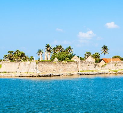
Many unexpected things happened during my trip to Sri Lanka. For example, I did not expect what I felt at the Dambulla Royal Cave Temple. Similarly, there are places like Puttalam. Puttalam stands out with its ancient history, wildlife, coconut plantation, and ideal ambiance for stargazing. However, of course, Puttalam is not as celebrated as the cultural richness of Kandy or the thrill of a Kandy to Ella train ride. It is more like a hidden gem. Now, talking about hidden gems, Mannar is another destination I almost missed. I am glad that I did not ultimately, as in recent times, it has become the land where women are fighting for the protection of the bodies and land impacted by industrialization, bypassing their consent. In this article, I will share my experience in Mannar, and of course, why women in this coastal village are putting up such a strong fight. However, I will begin with why I almost missed it. This Is Why I Almost Missed Mannar Mannar is not a usual or bucket-list destination when planning a trip to Sri Lanka. So, it was not originally on my list even after multiple visits to the country. For the first time, Jaffna and its Tamil culture were my priority. Also, for the next time, it was quite a predictable loop with Ella for the hills, Kandy for the temples, and Mirissa for the beaches. Again, while Mannar kept popping up as a suggestion, most forums described it as "connected by a causeway, has some baobab trees, not much else." So, I never had Mannar on my mind. However, when I visited Sri Lanka for the third time, my focus was more on historical exploration in the country that is so connected to the country I come from, India. So, I was staying in Anuradhapura, and Adeesha, the guesthouse owner, told me about Mannar. He said, “Mannar is where Sri Lanka forgets it's an island for a while. The wind never stops, and neither do the birds." This description stayed with me. And in three days, I took to the Medawachchiya-Talaimannar Highway for a road trip to Mannar. The distance was around 119 km, and it took around 2 hours and 17 minutes. Initially, I thought that it was a mistake as I saw the landscape flattening out into salt pans and scrub. However, I had not! Mannar Reminded Me Of Art Of Slow Travel: We All Know It But Often Forget I planned a half-day detour and ended up staying two nights, and even that felt like less. What I appreciated most was how little the island tried to perform for visitors. You don’t have a polished tour script to follow. Also, from the causeway moment to standing on the spot where two countries meet, you will not notice the crowd for photo ops. And do you know what you have as your companions here? Just baobabs older than most nations, donkeys that own the road, flamingos that don't care if you're watching, and a stretch of water that people once believed connected two entire countries! So, Mannar is more than worth being beyond an afterthought when you are planning a trip to Sri Lanka. I certainly did not expect a forgotten causeway town to end up as one of my favorite stops in the entire country, but that's exactly what happened. Here are more details about my days in Mannar, from the causeway moment to visiting the historical fort. 1. The Causeway Moment There's a specific moment on the drive-in that I still think about. I left the palm-fringed road of the mainland behind, and the land narrowed into a causeway with water pressing in on both sides. I rolled the window down, and I instantly felt the gush of wind on my face. My driver, Aslam, laughed and said I should get used to it. Talaimannar, further west, is considered one of the windiest points in the country, which is exactly why it's become a magnet for kite-surfers. Crossing that causeway felt like flipping a switch. The dense, wet green of the rest of the island gave way to something drier, flatter, and quieter. I hadn't expected Sri Lanka to have a landscape like this, and it was closer in spirit to the Deccan scrublands than to a tropical postcard. 2. First Impressions Of Mannar Town Mannar town itself is unhurried in a way that took me a day to appreciate. My first afternoon, I wandered past fishing boats pulled up on the shore, nets drying in loose piles. I also spotted a handful of tea shops where conversations paused just long enough for someone to glance at the obvious outsider before returning to their card game. Nobody tried to sell me anything. It was the first place in Sri Lanka where I felt like a guest rather than a customer. 3. Meeting The Giant Of Pallimunai I was not prepared for the first baobab tree I spotted in Mannar. Seeing it for real is a different experience than seeing the photos. The barrel-shaped trunk was wider than a small room, and the branches moved upward. Furthermore, it had a thick and wrinkled grey bark, which gave it the name of the “Elephant Tree” from the locals. However, the most famous one among the baobab trees in Mannar is the one in the village of Pallimunai. It has a history of 600 to 800 years. Furthermore, it was fascinating to think that baobabs are native to Africa and Madagascar, not South Asia. Common sayings are that the Arab traders carried the seeds here centuries ago, possibly using the leaves as camel fodder during the long sea crossings. The seeds eventually took root in Mannar's dry soil. I sat under that tree for a good twenty minutes, and a local teenager on a bicycle stopped to chat, half in English and half in gestures. He told me his grandfather used to tell him the tree was older than any building on the island. Looking up at it, I believed him completely. Things To Know About The Baobab Trees In Mannar Mannar has around thirty baobab trees scattered across the district. All of them are not as gigantic as you expect them to be. However, even the smaller ones along back roads and behind houses will grab your attention with their unique silhouette. 4. The Donkeys Of Mannar The feral donkeys are a part of Mannar’s wildlife identity. They come from the animals the Arab merchant brought generations ago. When I reached Mannar, I spotted them wandering freely across the island. They were unbothered by traffic or tourists. Even I watched one calmly block an entire lane of road near the causeway, chewing grass with the unhurried confidence of something that knows it has the right of way. Aslam just waited it out, grinning. "This is Mannar traffic," he said. 5. Flamingos At Vankalai My visit to the Vankalai Sanctuary and the nearby wetland was one of the highlights of my trip to Mannar. I spotted flamingos, and they looked unreal for the first few minutes. I have never been so up close to these majestic birds. Furthermore, I spotted a flock lift off a shallow lagoon at dusk, and it was dusk. So, they were catching the last orange light for the day. Everything around me paused for a while. 6. Adam's Bridge And Talaimannar: Standing Where Two Countries Almost Touch The furthest point of my trip was Talaimannar. It was right at the western tip of the island, where a chain of limestone shoals, the Adam's Bridge, stretches out toward Rameswaram in India. In Hindu tradition, this is the causeway said to have been built by Rama's army in the Ramayana. Furthermore, geologically, it is a natural formation due to sedimentation and shifting sea levels over thousands of years. The Moment… I was standing on the shoreline, and the wind hammered at my jacket. I squinted toward the horizon and tried to make out India. Certainly, I could not. Now, being from the land of spirituality, the myth was quite fascinating. However, the practical history seemed more tantalizing. It was one of the busiest pearl-trading points in ancient times, and it was famous even in Rome. 7. The Fort That Changed Hands Three Times On the way back, I stopped at Mannar Fort, a low, weathered structure sitting near the causeway. The Portuguese built it in 1560, and then the Dutch took over until they surrendered to the British. Compared to the grandeur of the Galle Fort or the Sigiriya Rock Fortress, it is a small, crumbling monument to how many empires passed through this one unassuming stretch of coastline. There wasn't a ticket booth or a gift shop. The caretaker nodded me through, and I wandered the ramparts alone, looking out over the water as the light started to fade. My Two Days In Mannar: The Itinerary Here is my two-day slow travel itinerary in Mannar. Day 1: Causeway, Town, And Giants Time ActivityMorningThe Road Trip to MannarLate MorningThe Causeway MomentEarly AfternoonCheck-in and Town ExplorationLate AfternoonThe Giant of PallimunaiEveningMannar "Traffic" and Dinner Day 2: Ancient Connections, Wildlife, And Heritage TimeActivityMorningJourney to TalaimannarMid-DayAdam's Bridge ExperienceAfternoonVisiting the Fort of Three EmpiresDuskSpotting Flamingos at Vankalai Sanctuary That’s it from my days in Mannar. However, I want to conclude with a brief discussion on how women in Mannar are fighting for their bodies and soil. Konniyan Kudiyirippu: A Mannar Village Where Women Fight For Their Bodies And Soil Konniyan Kudiyirippu is a small coastal village on the southern edge of Mannar. Here, the lives of the women revolve around the soil and palmyrah. However, the setting up of a windmill here without consent has ruined their lives by poisoning the water and flooding the land. That is not all! A mining company is eyeing this village. I was reading about this news on eathjournalism.net, and there, a 32-year-old woman and a kindergarten teacher from the village, Vashingtina, mentioned, “We use everything from nature to earn an income.” So, due to the industrialization without consent, the village economy based on nature is about to get ruined. The women of this village are putting up a fight against this and the violation of “the right to free, prior and informed consent.” So, come and visit Mannar to see how the women here are fighting one of the biggest battles of mankind, saving the environment vs. industrialization.

Excursion Packs LWMFTravel: What Are The Things To Keep In Mind Before Planning A Trip?
BY Sibashree Jul 9, 2026
All of us have a mixed experience when we are planning a trip. First, it is about finding a destination. Then, you decide on a budget and complete the bookings, including flights, trains, and accommodations. Then, you work on the itinerary. The entire preparation takes hours of your time. However, with excursion packs LWMFTravel, you can now enjoy the flexibility of time and experience for travel booking. You can love adventure, or you can be into deep cultural exploration. Furthermore, you may need to plan a family trip. Here is how you can plan a tailored travel experience easily. Know Excursion Packs LWMFTravel Excursion packs LWMFTravel are travel guides. These guides are destination-specific, and they are structured incorporating the following elements. Activity Recommendation Itineraries Specific Insights Based on Destination Specific Safety Advice Furthermore, for all these, you don’t need to explore different platforms. These packs give you a travel plan that you can customize, adopt, and follow. Also, these are not generic guides or travel blogs as they have clear actionability. What Is Included In The LWMFTravel Excursion Pack? CategoryWhat Is Included?Day-by-Day ItineraryA daily plan with timing guidance for activities, meals, and getting around.Sightseeing and Hidden Gems The essential landmarks and lesser-known local spots most tourists miss.Local TransportationHow to navigate buses, trains, taxis, and rentals, including costs and how to book them.Meals and DiningRestaurant picks and clarity on which meals, if any, come included in the package.Safety and Emergency InformationImportant precautions, local emergency numbers, and the nearest embassy or consulate contacts.Cultural EtiquetteLocal customs, dress expectations, tipping norms, and dos and don'ts to help you avoid missteps.Budget BreakdownEstimated costs across transport, food, activities, and lodging, so nothing catches you off guard.Packing ChecklistItems tailored to the destination based on climate, culture, and the activities planned. Why Are The Excursion Packs LWMFTravel The Smartest Choice? Finding information about traveling is not a problem these days. The issue is that the information is scattered. Excursion packs, on the other hand, are like consolidated sources where you can find all the necessary information under one umbrella. Furthermore, here are the benefits of using excursion packs LWMFTravel. BenefitsAdvantages for YouTime savingsSkip hours of research.The pack has already pinpointed the best attractions, the smartest routes, and the ideal times to visit each one.Budget ControlWith estimated costs for activities, transport, and meals laid out ahead of time, you can map your spending before you even leave home.Safety and ConfidenceUnderstanding the local safety situation, emergency contacts, and how transportation works locally eases travel anxiety.It is a big win for solo travelers and first-timers.Cultural Richness Unlock deeper local knowledge.Think markets off the tourist radar, restaurants locals actually frequent, and real context for the historical sites you visit.Flexibility within Structure Think of it as a flexible framework rather than a fixed schedule.Swap activities, stay longer somewhere, or skip parts entirely based on your mood and energy. Who Benefits The Most From The Excursion Packs? Excursion packs are beneficial for first-time as well as seasoned travelers. The in-depth research backing of the packs makes them stand out. Traveler TypeWhat They NeedFirst-Time International TravelersPlanning can feel like a lot to take in.They need straightforward guidance to move through it with confidence.Busy ProfessionalsShort on time to dig into research, they want every travel day to count.FamiliesFamilies need activity choices flexible enough to suit different ages and energy levels within the group.Adventure Travelers They are looking for detailed information on gear, safety, and logistics.Wellness and Nature SeekersThey want to safely and fully experience thermal springs, national parks, and nature reserves. What Are The Different Types Of Excursion Packs From LWMFTravel? LWMFTravel has diverse excursion packs for travelers of every style. Choose the pack you need based on your travel style to reap maximum benefits from the platform. 1. Outdoor And Adventure Excursion Packs You can kayak through beautiful coastal reefs or trek through rainforests. These packs will guide you in every adventure. Furthermore, these packs are suitable for climbers, divers, hikers, and all outdoor explorers. Here, you get all the recommendations on safety protocols, difficulty levels, gear selection, etc. Inclusions In The Adventure Excursion Packs Tour Operators and Guides A Checklist of the Gear Based on Activities Advice on Seasonal Timing and Weather Emergency Contact Details and Safety Protocols 2. Excursion Packs For Cultural Explorers If you are interested in art, history, and local life, the cultural and sightseeing packs are for you. These guides focus on details about the following places. Temples Museums Local Markets Historical Districts Furthermore, these packs are not the usual “Top 10” or “Top 20” lists. They offer authentic engagement by explaining the significance of visiting these places. 3. Excursion Packs For Family Trips It is a little difficult when you are planning a trip with children or elderly members. Furthermore, a family pack has to consider the following things. Flexible Pacing Activities for Different Age Groups Dining Options for Children Accessibility However, these excursion packs make travel planning with children and family easier as the logistics are well-planned. 4. Romantic Excursion Packs It is obvious that these excursion packs are suitable for couples and honeymooners. These packs include guides about: Scenic Locations Wellness Activities Fine Dining Options Private Experiences The goal is to make every trip memorable with more focus on the meaningful shared experiences among couples. 4. Travel Packs For Solo Travelers I am, by and large, a solo traveler as I have to travel for work. It feels empowering when you are done with your first or second trip. However, traveling solo has many different considerations, such as logistics, socializing, and safety. These solo travel packs offer solo-friendly travel suggestions, practical safety advice, and important tips for connecting with other travelers on the way. 5. Excursion Packs For Budget Travelers You do not always need a massive amount for traveling. You just need to plan the essentials well. In fact, the excursion packs for budget travelers focus on: How to eat well without spending much Free or affordable attractions in a destination Local or public transport options Budget accommodations These packs are ideal for students, backpackers, and young travelers. Overall, with these packs, you can optimize your travel experience with limited resources. 6. Don’t Forget The Meals-Included Packs We often ignore the meals-included packs. However, food is important not only for survival during a trip but also to maximize the trip experience. Furthermore, if you do not plan the meals right, you will end up spending unnecessarily, and there is often decision fatigue about food when you are in a different country. So, these meals-included packs help in the following ways. Spotting meal-inclusive dealsFinding travel packages and places to stay that already bundle in daily meals, so food costs aren't a mystery.Pointing you toward set-menu spotsSuggesting local restaurants where the pricing is fixed and predictable, with no surprises on the bill.Steering you to the real stuffFlagging genuine local dishes and food experiences that actually reflect the culture of the place you're visiting, not the tourist-trap version.Handling dietary needs on the groundCovering which spots accommodate specific diets and giving you the phrases or tips to explain restrictions to locals who may not speak your language. So, now you don’t need to feel clueless and waste your time thinking about what to eat from a street corner in Egypt or Malaysia. You know the safe choices, and it is always okay to experiment with your food unless that ends up in a stomach upset or allergic reactions ruining your trip. How To Make The Best Use Of Excursion Packs LWMFTravel? Follow this step-by-step guide to learn how you can use the excursion packs effectively. ActionsDetailsKnow your travel goalYou must choose between cultural explorations, adventure, or relaxation to refer to the right pack. Check the full itinerary You must go through the complete itinerary before leaving. Know the must-havesDifferentiate between the must-do things and things you need to avoid. Make advanced preparations for the logistics Complete the bookings in advance.Remain Flexible with Your Travel PlanBe flexible with minor changes in the plan. Choose From The Top Destinations In LWMFTravel Excursion Packs Excursion packs LWMFTravel offer diverse destinations. However, here are some top destinations. Destinations Why These Are Special Bali, Indonesia Spiritual TourismWellness RetreatsJungle AdventuresTokyo, JapanA Fusion of Traditional and Modern CulturesRome, ItalyHistorical ExplorationCulinary ToursBangkok, Thailand Cultural SitesStreet Food Budget TravelParis, FranceRomantic TripsWorld-Class Art ExplorationDubai, UAEDesert ExcursionsLuxury ExperiencesArchitectural ExcellenceNew York City, USADynamic City Exploration Safety, Responsibility, And Sustainable Travel A great excursion pack goes beyond fun. It promotes responsible travel. LWMFTravel emphasizes the following sustainability practices and ethics. Supporting local businesses Respecting cultural heritage sites Avoiding single-use plastics Staying informed on safety advisories Keeping digital copies of key documents. This isn't just good ethics, but it pays off. Travelers who engage respectfully with local communities often gain more authentic experiences, unlocking access beyond the standard tourist circuit. Excursion Packs Helping You Pack Smart Keep these things in mind when you are packing for your trip. Be Versatile and Light with Your Packing Choose Comfortable Clothes and Shoes that Match Your Travel Itinerary Carry a First-Aid Kit Keep Downloaded Guides and Offline Maps Handy Carry a Reusable Water Bottle Keep Digital and Physical Duplicate Copies of Your Documents How To Budget For An Excursion Trip Follow this simple format for budgeting. CategoryTipsAccommodationWeigh bundled package deals against booking independently.Also, going all-inclusive is often the better value.MealsOpt for meal-inclusive plans when you can, and keep some budget aside for one or two standout dining experiences.ExcursionsReserve guided tours ahead of time to avoid paying inflated last-minute prices.TransportationsRely on local transport when it's safe to do so, and account for airport transfers and travel between destinations.ExtrasKeep 15–20% of your overall budget in reserve for souvenirs, tips, and unplanned costs. You Must Avoid These Common Mistakes When Using Excursion Packs Even after using the packs for years, we can make some common mistakes. These mistakes, or I would say “misses,” happen as every travel destination comes with its unique character and challenges. Nevertheless, here are some mistakes that we need to avoid while using excursion packs LWMFTravel. 1. Underestimating Physical Demands You have to be honest with your physical and mental assessment when you are planning an adventure travel. Also, before you make the commitment, you must understand the difficulties you will be facing. 2. Don’t Overload The Schedule You cannot have an endless bucket list when making a travel itinerary. You have to decide the time frame and then be reasonable with logistics and the places/activities to cover. Otherwise, the trip will yield nothing but exhaustion. Also, don’t focus on the number of attractions/landmarks visited. Focus on the experience. 3. Overlooking The Cultural Guidance You cannot consider the sections on local etiquette as optional readings. Knowing about what to wear, local sentiments, and cultural traditions saves you from embarrassment and legal hassles. 4. Skipping The Travel Insurance You must have travel insurance even if the excursions are pre-organized. Unforeseen incidents can happen at any time, and insurance offers the necessary shield. 5. Local Booking Confirmations Are A Must You have to confirm all the bookings locally. This gives you a definite idea about meeting points and timings. It is okay that you are arranging everything remotely. However, things may change upon arrival if you do not confirm them locally. Excursion Packs LWMFTravel: Supporting The Changing Travel Demands You now do not need to hop between endless sources to plan a trip. Thanks to the excursion packs, you get well-structured and reliable guides in a consolidated form. In this way, the excursion packs LWMFTravel address the need for time-saving in modern travel planning. So, you can plan a family trip to Bali or a cultural trip to Tokyo. With these excursion packs, you will have the foundation to spend your money right and travel smart. Also, tailored and well-structured, these excursion packs make every destination enjoyable. Travel safe and smart! Bon Voyage! Read Also: Family Fish Thunderonthegulf: What Are The Things To Keep In Mind Before You Go? TTWeakHotel Discount Codes: How To Crack The Best Discount Codes And Deals? TheLowDownUnder Travel: A Heartfelt Guide For A Curious Traveler
Why Is Kurunegala Famous? What Are The Best Tourist Places In Kurunegala?
BY Sibashree Jul 9, 2026
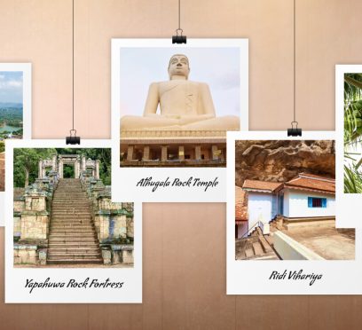
Kurunegala has recently been in the news due to infrastructure development. The cabinet meeting granted the construction of stage 1 of phase 4 of the Central Expressway Project. It will connect Kurunegala and Dambulla, which is famous for the iconic Dambulla Royal Cave Temple. The Road Development Authority (RDA) has further confirmed that the extension work will start in November 2026. However, Kurunegala has always been a melting pot for the cultural hub of Kandy, Puttalam, Negombo and the country’s capital, Colombo. Also, as the capital of the northwestern province, it holds massive strategic and political importance. Where Is Kurunegala? Kurunegala is in the north-western interior of Sri Lanka. As the capital of the Kurunegala District and the North-Western Province, it also functions as a major transportation hub. Furthermore, it is around 94 kilometers northeast of the country’s capital, Colombo. In addition, the distance between Kandy and Kurunegala is just 42 km. How To Reach Kurunegala? While traveling from Colombo, Kandy is the gateway to reach Kurunegala. I took a bus from the Kandy Goods Shed Bus Stand. Buses run regularly from Kandy to Kurunegala, or route 602, and the journey via Katugastota-Kurunegala Road (A10) takes around 1.5 to 2 hours. I traveled in a regular bus, and the ticket price was LKR 200. Semi-luxury, luxury, and super-luxury bus options are also available on this route, and the ticket prices will be between LKR 350 and LKR 600. Why Is Kurunegala Famous? Ancient Royal History! Majestic Geology! An Agricultural Powerhouse! These are the three main reasons behind Kurunegala’s prominent position in the tourism landscape of Sri Lanka. The Capital Of Ancient Kingdoms From the late 13th to the early 14th century, Kurunegala was the royal Capital of Sri Lanka. It was known as Hasthishaila-pura earlier, and under the rule of kings like Buwanekabahu II and Parakramabahu IV, it safeguarded the Sacred Tooth Relic of the Buddha. Also, including the Yapahuwa rock fortress, the silver cave temple of Ridi Viharaya, and the ancient ruins of Panduwasnuwara, the city has many historic ruins and citadels. The City Of Animal Rocks A ring of eight massive ancient granite outcrops encircles Kurunegala. These granite outcrops, suddenly rising from the plains, look surreal. Furthermore, my guide told me a fascinating folklore about these outcrops. “Kurunegala once faced a severe drought. Then, a witch turned water-guzzling animals into stone. In fact, some of these rocks are famously named after the animals their silhouettes resemble.” For example, Athugala looks like an elephant, Ibbagala looks like the back of a tortoise, and Andagala resembles an eel. The Heart Of The Coconut Triangle Kurunegala, like Kalutara, is famous for rubber estates. It also has endless coconut plantations. In fact, it is located inside the “Coconut Triangle" of Sri Lanka. So, overall, it is a prominent commercial hub for agricultural production. Moreover, it is the cradle of Selyn, Sri Lanka’s only fair-trade guaranteed handloom company. So, it is also a critical center for preserving the island's traditional textile heritage. What Are The Places To Visit In Kurunegala? Kurunegala offers the ultimate off-the-beaten-path experience in Sri Lanka. For me, the most fascinating places to visit here are the ancient rocks and the spiritual landmarks. While these connect you to history, the scenic waterways and modern sanctuaries allow you to unwind and soak in the local vibe. 1. Athugala Rock Temple Athugala dominates the skyline of Kurunegala. This outcrop has a height of 325 meters, and it gets its name from its uncanny resemblance to a giant, crouching elephant (Atha meaning elephant and Gala meaning rock). Furthermore, once I reached the summit, I found a magnificent Buddha statue of 88 feet in height. You can take a car ride to reach the summit. However, I preferred a trek through the stone steps. Fortunately, I reached the summit at sunset. So, the experience was magical. 2. Ridi Vihariya Or The Silver Temple Ridi Viharaya connects us to the 2nd century BCE. This ancient cave temple is around 20 kilometers away from the main town in Rideegama. King Dutugemunu discovered a rich vein of silver ore here. Then he used the silver ore to finance the construction of the famous Ruwanweli Maha Seya in Anuradhapura. Furthermore, Ridi Vihariya is hidden by rocky cliffs and forest cover. Also, it is home to a magnificent reclining Buddha statue, Kandyan-era frescoes, and ivory carvings. 3. Yapahuwa Rock Fortress The Yapahuwa Rock Fortress is often compared to the Sigiriya Rock Fortress. Yapahuwa was the capital of Sri Lanka under King Bhuvanekabahu I in the late 13th century. Furthermore, the temple is constructed against a sheer, 200-meter-high granite rock that juts dramatically out of the surrounding jungle. Moreover, it has a highly ornamental staircase. Stone lions and intricate carvings adorn the path. What is more fascinating than these steps, which once led to the royal palace and the Temple of the Sacred Tooth Relic? 4. Panduwasnuwara Ancient City Panduwasnuwara, which served as a temporary capital in the 12th century, is a dramatic ruin site. It has a well-defined citadel surrounded by protective moats and thick ramparts. Furthermore, inside the citadel, there are the foundations of a two-tiered royal palace, complete with ancient latrines and footings for wooden pillars. However, the Ektem Maligaya, or the perfectly circular tower, was the most fascinating feature of the Panduwasnuwara ancient city. Local folklore links it to romantic legends of hidden princesses, while historians believe it was used by King Parakramabahu for swearing-in allegiance rituals. 5. Kurunegala Lake (Rantalia Tank) Kurunegala Lake is the ultimate place to unwind after a busy day. It is at the foot of the animal rocks. I loved walking along the well-paved path hugging the banks. You can also do a pedal-boat ride on the lake. Furthermore, you can just relax sitting in the nearby restaurants and trying authentic Sri Lankan cuisine. 6. Arankele Forest Hermitage Arankele is a meditation retreat. It was originally built for austere Buddhist monks, and with untouched jungle, it still exudes a strong spiritual vibe. As I walked through the stone-paved paths, I came across the ancient Padhanagharas or meditation halls, sun-dappled ponds, cave dwellings, and Jantagharas or the houses for hot water baths. The hermitage is covered by a dense canopy, keeping it quiet and cool, and here, you will only listen to distant bird calls and the rustle of leaves. Where To Stay In Kurunegala? Kurunegala offers accommodation options that cater perfectly to both city-center conveniences and quiet countryside getaways. In Kurunegala, you can choose your accommodation based on the kind of experience you want. Here, you will find options that cater perfectly to both city-center conveniences and quiet countryside getaways. City Hotels And Business Stays If you want to stay close to the city, Kandyan Reach Hotel is an excellent option. It has comfortable rooms, an outdoor swimming pool, and proximity to major transport lines. Also, it is a mid-range choice for travelers exploring the downtown rocks. Nature Resorts And Luxury Estates If you love tranquility, you can choose the eco-lodges in the surrounding districts or the heritage properties inside the coconut plantations. For example, the Coco Forest Resort offers an excellent farm-stay experience.
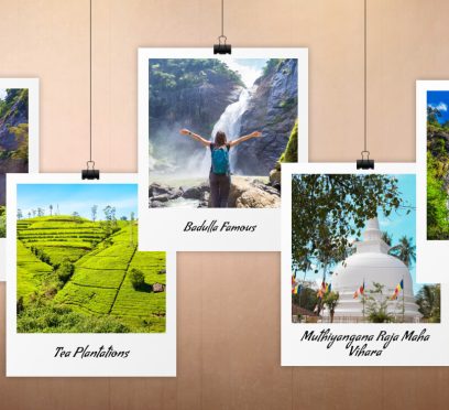
What Is Badulla Famous For? What Are The Best Places To Visit In Badulla In 2026?
BY Sibashree Jul 9, 2026
It’s great that Badulla has slowly and steadily bounced back after the rampage of Cyclone Ditwah in December 2025. With proactive measures, the Badulla–Haputale railway line was restored in just 18 days, and it’s great that in 2026, with its iconic landmarks such as the Demodara Railway Loop remaining a serene hill-country town. Moreover, this serene stop on the iconic Kandy-to-Ella railway route has ancient temples, cascading waterfalls, and misty tea plantations. So, if you want to enjoy a place with a cooler highland climate such as Nuwara Eliya, Badulla will be the go-to place. In this article, I will discuss why Badulla, the capital of Sri Lanka's Uva Province, is famous. The places to visit and more. However, let’s begin with its location. Where Is Badulla, Sri Lanka? Badulla is in the southeastern part of the central hill country of Sri Lanka. Furthermore, it is at an elevation of 680 meters. So, it enjoys a misty, cool climate. In addition, the surrounding tea gardens and the Badulu Oya River make it a sought-after hill station. In addition, the Namunukula mountain range overlooks this hill country town as the supervising guardian. Moreover, it is located at a distance of around 230 km east of Colombo. Why Is Badulla Famous? Badulla, in the central highlands of Sri Lanka, is cherished for its unique colonial engineering. At the same time, it is a place where nature and history meet. However, the most significant aspect of this highland is its spiritual heritage. As a result, Badulla is an iconic ecotourism destination, and it is also ideal for someone who is fascinated by architecture and history. Scenic Wonders And Ecotourism Cascading waterfalls and a dramatic mountain terrain dominate the landscape of Badulla. The Dunhinda Falls, with its height of 64 meters, is the iconic landmark that draws visitors from across the globe. Again, the majestic Namunukula mountain range surrounds the central highland. This mountain range, further, is a sanctuary for avid hikers, campers, and nature enthusiasts seeking panoramic vistas of the Uva Province. Moreover, thanks to the geographical features, Badulla has a microclimate ideal for growing some of the world's finest high-grown Ceylon teas. So, Badulla has endless green estates terracing the valley walls. Historic Architecture And Heritage Sites Badulla is not just an ecotourism hotspot. It is way beyond a living museum depicting the diverse history of Sri Lanka. The Muthiyangana Raja Maha Vihara is at the heart of Badulla. It is an ancient temple complex, and it is sanctified by a visit from Gautama Buddha. So, it is a significant pilgrimage site for the Buddhists. Another significant architectural marvel on the site is the Bogoda Wooden Bridge. This 13th-century bridge has no metal nails. Again, the Demodara Nine Arch Bridge is a classic example of colonial architecture. This iconic stone railway viaduct stands as a testament to early 20th-century British engineering and remains a globally recognized symbol of Sri Lankan travel. What Are The Places To Visit In Badulla? Badulla is versatile, as I have already mentioned. So, I have divided the places to visit in Badulla into three main sections: the natural attractions, the spiritual and religious places, and the architectural attractions. Natural Attractions To Explore In Badulla It goes without saying that Badulla, as an iconic ecotourism hotspot, will have many natural attractions. 1. Dunhinda Falls The Bride’s Veil Falls, or the Dunhinda Falls, is very close to Badulla Town. I could hear the roaring sound of the waterfall from a distance. As I followed the roar and reached the waterfall, the journey culminated in an amazing view of plunging water. 2. Diyaluma Falls The second-highest waterfall in Sri Lanka, the Diyaluma Falls, stands at the end of an adventurous hike from Badulla. It is around 60 km away from Badulla, and the travel time is around 2 hours. Furthermore, the Diyaluma Falls are so beautiful that after reaching the base, I opted for an adventurous hike to the top. The views were incredible, and I even took a dip in the refreshing pool formed below. However, always listen to the local guides and check the weather updates before visiting the Diyaluma Falls. 3. Tea Plantations And Viewpoints Badulla looks like a carpet of green with the tea plantations on the hillsides. These tea gardens do not just offer lush greenery. These are also great locations for learning how tea is processed and how the transformation from leaves to cup happens. Religious And Spiritual Places To Visit The Muthiyangana Raja Maha Vihara and Dowa Rock Temple are two important religious landmarks in Badulla. Muthiyangana Raja Maha Vihara You can find the mention of the Muthiyangana Raja Maha Vihara in the Mahavamsa chronicle itself. King Indaka, a chieftain of the Deva tribe, built this Vihara in the 5th century. However, King Devanampiyatissa transformed this structure into a formal temple complex. This temple is so significant as Lord Buddha visited it. Furthermore, the Muthiyangana Raja Maha Vihara has impressive architecture. The stupas and the stone structures here are the quintessence of important Buddhist sites in Sri Lanka, such as the Dambulla Royal Cave Temple and the Gal Vihara in Polonnaruwa. Dowa Rock Temple The power of unfinished art and what it signifies! Everything is for you to interpret, and there are thousands of possibilities about why the art could not be completed. This is what I felt after seeing the Dowa Rock Temple. Carved into a giant rock face, this temple has an unfinished and giant statue of Lord Buddha. The scale and the intricate carvings of the temple were amazing, and they showed the mastery of the Sri Lankan artisans in the ancient age. You will even get a glimpse of the religious and artistic heritage of the island country. Architectural Marvels In Badulla Walking on the Bogoda Wooden Bridge is like connecting to ancient times. The air there felt very different, and it immediately transported me 400 years back. Furthermore, the tiled roof of the bridge is a telltale of the Sri Lankan engineering excellence in ancient times. Moreover, when you are in Badulla, don’t miss the spicy vegetable and meat curries and rice.
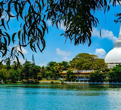
Why Is Kalutara So Famous? Know The Best Things To Do In This Historic Coastal Town
BY Sibashree Jul 8, 2026
Visit Kalutara if you are not already smitten by the whiff of fresh tea and cinnamon together; you must visit Kalutara. The Kalu Ganga river, the fertile tropical soil, and the proximity to the Indian Ocean have made the region ideal for the cultivation of tea, rubber, and cinnamon since British rule. So, when I reached Kalutara, I saw women wearing colorful sarees plucking fresh tea leaves and storing them in the hessian sacks hanging on their backs. Furthermore, the iconic Richmond Castle, at a short distance from the Kautara City, and many architectural features here are remnants of colonial heritage in this historical town. In this article, I will talk about the location of Kalutara, how to travel to it, why it is so famous, the things to do, and more. I will also share my experience filled with the visuals of cinnamon peelers and rubber tappers and the salty fragrance of the Indian Ocean. Where Is Kalutara? At a distance of around 42 kilometers from Colombo, the capital of Sri Lanka, Kalutara is on the western coast of Sri Lanka. You reach this coastal town after a drive of 1 to 1.5 hours from Colombo. Furthermore, Kalutara is the gateway to popular beach towns like Galle and Bentota. Kalutara is most revered for the Kalutara Bodhiya Stupa, and the sweet purple mangosteen fruits here are another signature of the coastal town. How To Reach Kalutara? The journey to Kalutara from Colombo on the southern railway line is one of the most beautiful train journeys in Sri Lanka. Furthermore, you will get public and private buses for the journey, and you can even book a private vehicle for the transit. Here are more details about the transport options. 1. Colombo To Kalutara By Train You will get many trains from Colombo Fort to Galle, Kalutara South, and Matara. Trains are available throughout the day and from as early as 5:39 AM. Furthermore, the last train for the day to Kalutara departs Colombo Fort at 9:36 PM. Also, the travel time is between 48 minutes and 1 hour and 20 minutes. In addition, the ticket price for travel in a third-class coach is LKR 480. 2. By Bus Public, private, and air-conditioned buses are available from Colombo to Kalutara. These buses run on the Galle Road. These buses take around 3 hours and 30 minutes, and the ticket price is approximately LKR 600. 3. By Private Transport The short distance between Colombo Fort and Kalutara is ideal for travel by car. The travel time will be around an hour, and the cost will be between LKR 3500 and LKR 4500. You can either take the Galle Road for the commute or the Southern Expressway ( E01) as a faster alternative. 4. Moving Around In Kalutara Kalutara is very much walkable, or you can take a tuk-tuk to move around. Furthermore, you can rent a bike or bicycle for a day to explore the coastal town at your own pace. The rental charge will be around LKR 2500 to 3500 per day, and the rental agency will help you with the local driving license or other permit you need. Why Is Kalutara So Famous? The city of mangosteen and home to the Gangatilaka Vihara, the only hollow Buddhist Stupa in the world, Kalutara awaits with an air that is heavy with history, spirituality, and the stories of the bonding between humans and nature. I have been to the Dambulla Royal Cave Temple and the Gal Vihara in Polonnaruwa. Kalutara felt like an extension of my visits to those places. 1. The Gangatilaka Vihara My jaw dropped as I stepped out of the humid coastal air and into the echoing, cool interior of the Gangatilaka Vihara. The massive dome soared above me, and I found the inner walls covered in 74 intricate, vibrant murals depicting the life of the Buddha. Also, as I was inside the Gangatilaka Vihara, the traffic on the busy Galle Road got transformed into a soft hum, and the air was filled with the gentle chanting of pilgrims clad in white. 2. The Secrets Of The Sacred Tree I left the giant stupa and found the Kalutara Bodhiya just across the road. I felt the high energy instantly and was staring at the massive, ancient Bodhi tree. A friendly local devotee named Anura noticed me, and she confirmed the facts I had read. This tree grew from one of the original 32 saplings of the Jaya Sri Maha Bodhi in Anuradhapura, linking it back over two millennia. Also, as I sat close to the tree, I found drivers stopping their vehicles in the middle of the bustling highway, stepping out just long enough to drop a few coins into a donation box for a blessing before driving on. Then, I performed the common ritual by pouring a small clay pot of water over the sacred roots. The sheer energy of hundreds of people whispering prayers in unison under the rustling leaves gave me goosebumps. 3. The Magnificence Of A Coastal Castle Kalutara is also about colonial opulence. This castle is on a 42-acre estate, and it was built in 1896. This feels like a grand British manor house dropped straight into a Sri Lankan spice forest. As I walked through the grand banquet hall, I was amazed by the blend of Indian and British architecture. The caretaker pointed out the intricate timber work, bragging that the wood had been imported all the way from Burma. Standing on the sweeping balconies, looking over the sprawling grounds, it was easy to picture the extravagant, high-society parties that once took place here during the height of the rubber boom. Sunsets, Straw Hats, And Purple Fruit The natural geography of Kalutara also makes it stand out. The Calido Beach, especially, is magical in the late afternoon. This is a narrow spit of land where the freshwater Kalu Ganga (Black River) runs parallel to the crashing saltwater waves of the Indian Ocean. Then, I sat on the sand and watched the local fishermen battling the currents where the river meets the sea, the sky turning a brilliant shade of bruised purple. On my way back, I stopped at a roadside stall where an elderly artisan was weaving palm leaves into a vibrant sun hat. Remember that Kalutara is Sri Lanka's "basket capital," and watching her fingers fly was hypnotizing. Also, before I left the stall, she handed me a magosteen and a dark purple fruit. I cracked open the thick, leathery rind to reveal snowy, delicate segments. The taste was an explosive mix of sweet and tangy, a perfect edible summary of Kalutara itself: bright, surprising, and utterly unforgettable. What Are The Other Things To Do In Kalutara? Along with the iconic landmarks that make Kalutara famous, some other attractions and activities await you in Kalutara. 1. Finding An Escape In The Brief Garden The Brief Garden was the former residence of Brevis Bawa, one of the most iconic architects of Sri Lanka. It stands out with its artistic beauty, and that artistry blends well with the rich flora and fauna and fascinating sculptures. I enjoyed a stroll in this delightful garden. While walking through the hidden alleys and nooks, I enjoyed every bit of the artistic ambiance. 2. Going For A Guided Hike In The Sinharaja Forest Reserve The Sinharaja Forest Reserve is a UNESCO World Heritage Site. UNESCO designated this as a heritage site in 1998. About the forest reserve, the UNESCO World Heritage Convention further mentioned, “More than 60% of the trees are endemic and many of them are considered rare. There is much endemic wildlife, especially birds, but the reserve is also home to over 50% of Sri Lanka's endemic species of mammals and butterflies, as well as many kinds of insects, reptiles and rare amphibians.” Moreover, the forest reserve has more than 450 species of trees. It even has hidden waterfalls forming clear streams. I could even spot the most vibrant tree orchids. The nature trails here are well-maintained, and the hiking experience becomes all the more delightful with the chirping of the birds. So, if you are planning a trip to Sri Lanka and want the best wildlife experience, you must add the Sinharaja Forest Reserve to your itinerary, along with the Yala National Park, Delhiwala Zoo, etc. 3. Spotting The Nesting Turtles At Kosgoda Turtle Hatchery The Kosgoda Sea Turtle Conservation Project, founded by Dudley Perera, is located approximately 27.7 kilometers south of Kalutara along the Galle Road (A2). It took around 40 minutes for me to reach the spot on a bike. This project has been dedicated to monitoring the sea turtles here for three decades. They work to preserve these endangered animals and want to spread awareness about them. The remarkable hatchery here focuses on collecting and rescuing eggs and storing them in a haven. Furthermore, after the eggs are hatched, the turtles are only released into the ocean when they can fight the predators. 4. Trying The Spicy Local Cuisine Kalutara has a rich history of spice trading. So, as expected, Kalutara has a culinary culture worth exploring. Furthermore, every dish stands out with a perfect balance of zest, sweetness, and spice. Rice and curry, freshwater fish baked in banana leaves with coconut, tamarind, and mustard paste are some of the best dishes to try. 5. Exploring The Handunugoda Tea Plantation Do you want to extend your travel plans in the Handunugoda Tea Plantation a little? Then, you can travel for around 1 hour and 30 minutes and reach the Handunugoda village. This tea plantation is famous for producing the “Virgin White Tea.” Moreover, you can take a guided tour of the tea plantation and see the tea pluckers in action. A Trip To Kalutara: Know The Perfect Itinerary Two to three days are enough if you want to have an immersive experience in Kalutara. So, here is a 3-day itinerary for you. DaysTimeActivityKey Highlights and Cultural InsightsDay 1MorningVisiting the Gangatilaka ViharaThe only hollow Buddha Stupa in the world. Late MorningKalutara Bodhiya and Sacred TreeThis tree grew from one of the original 32 saplings of the Jaya Sri Maha Bodhi in Anuradhapura. LunchTrying Spicy Local CuisineEnjoy a traditional rice and curry lunch. Taste local freshwater fish baked in banana leaves with coconut, tamarind, and mustard paste.AfternoonVisiting Richmond CastleExplore this grand 1896 Edwardian mansion built on a 42-acre estate. Marvel at the blend of Indian and British architecture and the Burmese timber work.Late AfternoonVisiting Calido Beach and Watching Palm WeavingWalk the narrow coastal spit where the Kalu Ganga meets the sea. Watch artisans weave vibrant straw hats from palm leaves and sample fresh, sweet mangosteens.Day 2MorningVisiting the Brief Garden by Bevis BawaTake a stroll through the former residence of iconic architect Bevis Bawa. Explore hidden alleys, rich flora, and fascinating sculptures blended into nature.AfternoonLearning Experience at Kosgoda Sea Turtle HatcheryTake a 40-minute ride south along Galle Road to Dudley Perera's conservation project. See how endangered sea turtle eggs are rescued, incubated, and safely released.EveningSunset and Coastal RelaxingHead back up the coast to Kalutara for a quiet seaside evening, taking in the purple-hued sunset away from the busier commercial beach crowds.Day 3Full Day (Option A)Hiking in the Sinharaja Forest ReserveEmbark on a guided nature trek through this UNESCO World Heritage Site. Spot endemic birds, rare butterflies, wild orchids, and hidden forest waterfalls.Full Day (Option B)A Visit to the Handunugoda Tea PlantationTravel 1.5 hours south to visit the famous home of "Virgin White Tea." Take a guided estate tour, see tea pluckers in action, and learn about the delicate processing. From modest homestays to luxury hotels and resorts such as Avani Kalutara, Kalutara has diverse modes of accommodation. These will cost around LKR 5000 to 50000 per person per night.
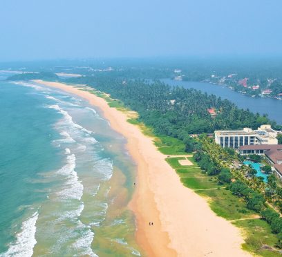
Why Is Bentota Beach, Sri Lanka, Famous? Know About Bentota Beach, River Safari, And More
BY Sibashree Jul 7, 2026


