

Kalpitiya, Sri Lanka: The Sandbar Where The Wind Runs The Show

Mullaitivu left me quiet with the heavy history of the Sri Lankan Civil War. 

And Kalpitiya was another surprise during my trip to Sri Lanka.

Kalpitiya is a kitesurfing town, and in fact, Kalpitiya has been an important spot to boost tourism in Sri Lanka for the last 15 years with its kitesurfing adventures. 

Furthermore, in September 2025, Kalpitiya saw its longest kitesurfing adventure, “a nearly 200-kilometre journey from Anawasala point in Kalpitiya to Talaimannar.” 

Surfers from Sri Lanka, Italy and Germany took part in this surfing adventure. Also, Sara Johanna Berg, while speaking to The Sunday Times, said, 

“This water sport is spectacular, not only to practice but also to watch. However, it requires proper training and guidance.”

Sara also mentioned that with this event, she expected more participation from the Sri Lankan surfers. 

Nevertheless, Kalpitiya was more than a wind-scoured sandbar with a fort. It is also home to a distinct fishing culture. And yes, you will see many dolphins, probably the calmest in Kalpitiya. 

Here is what I did during my three days in Kalpitiya. This stretch of the northwest coast deserves more than a footnote in a Sri Lanka itinerary.

Kalpitiya Took Me By Surprise From The Moment The Journey Started

Kalpitiya is around 165 to 170 kilometers north of Colombo. A drive takes around three and a half hours. 

It is a peninsula in the Puttalam District and is located around 50 kilometers north of Puttalam Town. 

Furthermore, squeezed between the Puttalam Lagoon and the open Indian Ocean, Kalpitiya is a place famous for wind, kites, and dolphins. 

However, the journey from Colombo to Kalpitiya was no less “interesting.” 

Past Puttalam, the road narrowed, and the land on either side turned into salt pans, catching the light in long silver-white sheets.

My driver this time was Nimal, and he slowed down so I could photograph a row of old windmills turning lazily near the salterns.

Every detail on the way felt more like rural Netherlands than tropical Sri Lanka.

Nimal said, 

This whole peninsula used to belong to traders.

Then, he pointed toward the lagoon side and said, “Arabs, then the Portuguese, then the Dutch. Everyone wanted this exact strip of sand.

The Places To Visit In Kalpitiya 

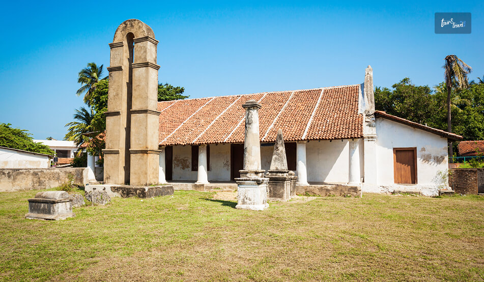
What Nimal said made more sense to me when I reached Kalpitiya Fort, the main historical attraction in Kalpitiya. 

It was a fort that guarded a Cinnamon route. Here are more details about the fort. 

Kalpitiya Fort: Embodying The Portuguese And Dutch History

Kalpitiya Fort Embodying The Portuguese And Dutch History

The Portuguese had laid the foundations of the Kalpitiya Fort earlier, and the Dutch built the fort on it between 1667 and 1676. 

It sits on the narrow point where the Puttalam Lagoon meets the sea. 

The walls of the fort are around four meters in height, and these are made of coral and limestone quarried from the surrounding coast.

Also, the single entrance to the fort faces the lagoon. Furthermore, the belfry and the pediment topping the entrance make it look like a church.  

However, this resemblance is not an accident.

The local accounts say that the Dutch built the entrance in that style to placate the Kandyan king who had granted them the land.

It was at a time when the fort’s real purpose was military and commercial rather than religious. 

A Guard To The Puttalam Lagoon

The Kalpitiya Fort guarded the entrance to Puttalam Lagoon.

The Dutch used the lagoon as a corridor to move cinnamon, areca nuts, and pearls toward Colombo. They had even dug a canal through Negombo for the purpose.

However, today, the fort functions as the navy base of Sri Lanka. If you want to visit this fort, you will have to carry your original passport as it is still an active military site. 

A young naval officer volunteered to show me around, and as I walked the bastions, the fort looked out over the lagoon on one side and the ocean on the other.

The two bodies of water were separated by a strip of land I could have walked across in under ten minutes.

Kudawa Beach: The Line Between Two Seas

Kudawa Beach The Line Between Two Seas

From the fort, I took a short ride to Kudawa Beach. 

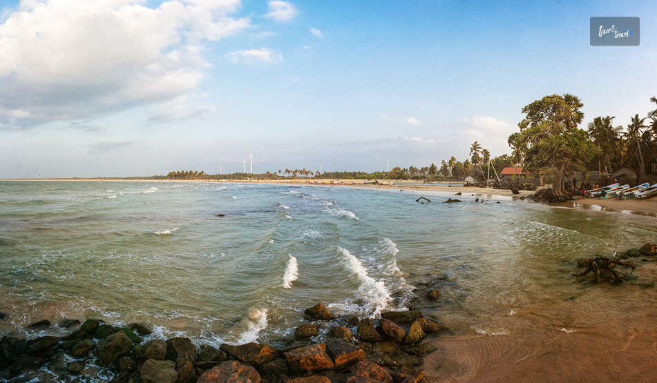
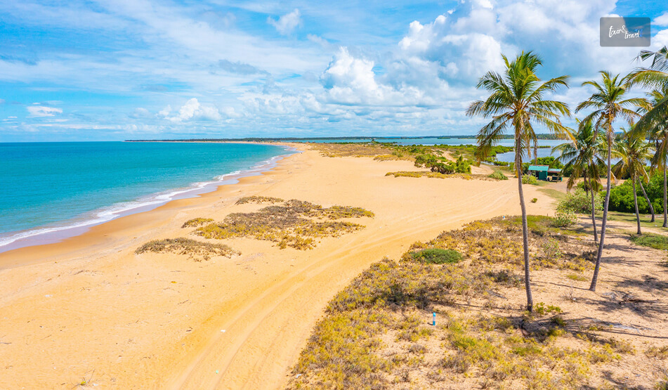
It is the main stretch of sand in Kalpitiya, and here a narrow sandbar visibly divides the turquoise ocean from the murkier, nutrient-rich lagoon. 

I arrived at the beach close to sunset, and without exaggerating a bit, it was the single sundowner spot I found anywhere on this Sri Lanka trip. 

There were no large resorts crowding the shorelines. However, there are around 30 kitesurfing schools around the coastlines and lagoons. 

Also, there are small eco-resorts, and a handful of fishing huts with nets strung out to dry. 

At the beach, a fisherman mending his net nearby told me, half in English and half through gestures, that the wind here “never really stops between May and October.” 

I had to agree with him, as even if I stood still, my shirt kept snapping against my back. 

What Are The Things To Do In Kalpitiya? 

What Are The Things To Do In Kalpitiya

I had a wonderful time chasing the dolphins and trying to learn kitesurfing. Here is more about the best things to do in Kalpitiya. 

1. Chasing Dolphins Before Sunrise

Dolphin watching is the best experience to have in Kalpitiya. 

Our boat left from the lagoon, and it charged LKR 4000 per head. 

It was just after sunrise. So, the sea was at its calmest.

The boat headed out toward the Bar Reef area, where we spotted the spinner dolphins. I tried to keep a count, and it was close to sixty. 

Our guide told me that spinner dolphins are regular in this region between November and April. He mentioned spotting the “super-pods” of over a thousand dolphins during peak months. 

The dolphins did not perform tricks for us, and they simply existed around the boat. They spun, leaped, and occasionally arrowed straight toward the hull before diving under at the last second.

Our boat operator mentioned that between December and April, this area also has sperm whales and sometimes migrating blue whales. 

Each time a pod appeared, our boat operator cut the engine. Thus, the boat drifted rather than chasing them. 

He said it was a “standard practice” among the more responsible operators working the Bar Reef, one of Sri Lanka’s largest reef systems at roughly 307 square kilometers.

2. Learning To Kitesurf (I Failed At It)

Kalpitiya’s lagoon side is shallow and flat almost by design, which is exactly why it has built its reputation as one of the best beginner-friendly kitesurfing spots in Asia. 

However, I was not a natural. 

My instructor, a wiry local guy named Dinesh who has been teaching on this lagoon for years, kept the lesson simple. “Control the kite first. The board comes later,” he said, which is probably decent life advice too.

However, I barely made it. So, you must not trust the term “beginner-friendly” completely. 

What Is The Best Season For Kitesurfing In Kalpitiya? 

Kalpitiya has two kitesurfing seasons. 

The southwest monsoon, from May to October, brings strong, consistent wind for most of the day. So, it is for professionals and veterans. 

On the other hand, the northeast monsoon, from December to March, is gentler and generally considered the better window for first-timers.

I went in the second season. Still, I spent most of the first hour eating sand. 

3. Exploring The Places Near Kalpitiya 

Wilpattu National Park, the largest national park in Sri Lanka, is close to Kalpitiya. It is a drive of about 2 hours. 

The Wilpattu National Park is also famous for having a dense population of leopards. If you want to stretch the trip a little, you can visit the national park and plan a day safari. 

Moreover, the peninsula itself is scattered with fourteen small islands, some inhabited by fishing families, some given over entirely to mangroves and birdlife.

You can even explore these islands for a meaningful cultural experience.

How I Spent Three Days In Kalpitiya: The Itinerary 

DaysTimeActivity
Day 1MorningDrive from Colombo via Puttalam, Salt Pans and Windmills
AfternoonVisiting the Kalpitiya Dutch Fort
EveningSunset at Kudawa Beach
Day 2Early Morning Dolphin Watching Boat Trip Near Bar Reef
AfternoonRelaxing by the Lagoon
EveningTrying Fresh Seafood by the Beach
Day 3Early MorningKitesurfing Lesson
Late MorningDay trip toward Wilpattu National Park
Afternoon Island-hopping by Boat, Mangroves and Birdlife

Kalpitiya: A Coastline That Is Still Deciding What It Wants To Be 

Kalpitiya never tries to be Galle or Mirissa Beach. This is where it wins hearts. 

With its patchy hot water, basic rooms, and winds, it is as unpolished as Nimal warned me to be. 

But between a 350-year-old fort, a reef full of dolphins, and a lagoon that has quietly become one of the best kitesurfing classrooms in Asia, Kalpitiya gave me more range in three days than most single-purpose beach towns manage in a week.

If you are the kind of traveler who wants your itinerary to include a little bit of history, a little bit of wildlife, and a lot of wind in your hair, I would put this stretch of the northwest coast near the top of your list.

Share on Social Media

Sibashree is a travel, culture, and leisure writer who has been writing since the age of 12 and professionally since 2014. With more than a decade of travel writing experience and journeys across India and several parts of the world, she brings a deeply personal and thoughtful perspective to her work. A student of English Literature and Mass Communication, Sibashree has always viewed travel as more than movement — for her, it has been a way of understanding people, cultures, and herself. Her passion for spiritual exploration has also led her to many unusual and meaningful destinations over the years. Outside of writing, Sibashree enjoys watching European cinema, reading about global politics, and reflecting on the stories hidden within everyday places.

Leave a Reply

Your email address will not be published. Required fields are marked *

title-img Related

READ MORE Ravana Falls

Ravana Falls, Ella: Location, How To Reach, Things To Do, Practical Tips And More

BY  Sibashree Aug 22, 2026

I met Ravana Falls on the way from Ella to Wellaway.  I pulled up on a tuk-tuk and found a wide and tiered curtain of water falling down on an oval rock face.  Ravana Falls is not the tallest or most powerful waterfall you will see in Sri Lanka. However, the mythological significance and its easy accessibility from Ella make it a must-visit.  Some Quick Facts About Ravana Falls, Ella FactsDetailsOfficial NameRavana Falls (Ravana Ella)LocationElla, Badulla District, Central Highlands, Sri LankaHeight25 MetersWaterfall TypeA Three-Tier CascadeWater SourceKirindi Oya (River System)Mythological LinkThe RamayanaAccessibilityRoadside Viewpoint with No Trekking RequiredBest Time to VisitOctober to January for Maximum Water VolumeEntry FeeFree Where Is Ravana Falls Located?  The Ravana Falls shows its prowess along the Ella–Wellawaya road (the A23). It is around 6 to 8 km south of the beautiful Ella Town.  Also, it is close to the 12th–13th mile markers in the Badulla District. At an elevation of around 1050 meters, this waterfall drops around 25 meters, and it is one of the widest in Sri Lanka.  Furthermore, this waterfall within the compact Ella Wildlife Sanctuary is at the epicenter of an ecosystem with birds and small mammals. Overall, it is amidst a landscape typical of the mid-elevation forests of Sri Lanka.  How To Reach Ravana Falls A tuk-tuk ride from central Ella to Ravana Falls takes around 10-15 minutes. You can also take a taxi ride.  As you proceed toward Wellawaya along A23, you will see this waterfall from the roadside.  Public buses also run along this route, and drivers are used to being asked for a drop-off here. Moreover, you can reach the Ravana Falls from Bandarawela. You can reach the waterfall by traveling around 10 km toward Wellawaya from Kubalwela Junction on the Badulla–Bandarawela road. Ravana Falls And The Legend Of King Ravana  The most intriguing thing about the legend of Ravana Falls is that every guide will give you a different version.  However, the most popular is that King Ravana, the demon king from the Ramayana, hid Goddess Sita in a cave behind this waterfall after abducting her and bringing her back to Lanka.  The waterfall is also close to the Ravana Ella Cave, which is perched on a cliff face about 11 km from Bandarawela. The archaeological evidence in the area has proven the presence of older human habitation. So, myth aside, it has been an important location for human habitation for a long time.  What To Do At Ravana Falls? The best vantage point for this waterfall is the road and the small bridge nearby. If you want to go closer to the base, you will have to walk down a little.  As you reach the base, you can climb over some of the rocks.  Here, you have to be very careful as these rocks are very slippery irrespective of the season.  Furthermore, for a proper look at the multi-tier cascade, I waded in the lower pools.  However, I could not climb higher up the falls toward the upper cascades as that route is now restricted due to past accidents.  So, I had to stick to the lower areas.  Moreover, I spotted many troops of wild monkeys near the waterfall. So, be careful about what you carry and be respectful to them.  Other Nearby Places You Can Visit With Ravana Falls  After exploring Ravana Falls, you can come back to Ella and find some of the photographed attractions in Sri Lanka. Visit the Nine Arch Bridge, Ella Rock, and Little Adam's Peak. Once again, due to the proximity to Ella, Ravana Falls fits naturally into a half-day loop rather than requiring a dedicated trip. Moreover, just two hours away, the Horton Plains National Park awaits with a completely different high-altitude landscape.  Practical Travel Tips For Visiting Ravana Falls Ravana Falls is one of the best places to visit in Sri Lanka for budget travelers as it offers free entry.  You must wear shoes with good grip if you have plans of climbing over the rocks near the base. Once again, avoid the temptation to go beyond the marked and accessible sections.  A Quick Note On Safety Follow the restrictions seriously, and there is no need to push barriers for a better photo, risking your safety.  Like the other waterfalls in Sri Lanka, Ravana Falls should also be visited with prior local advice.  Only a local guide will be able to help you find out the safer pool.  Where To Stay Near Ravana Falls? Ella town is the obvious base, and it is small enough that nowhere is more than a short tuk-tuk ride from the falls.  Guesthouses and small boutique hotels line the roads toward Passara and Wellawaya. Many of these guesthouses offer valley or mountain views. Also, the range of options runs from simple backpacker stays to higher-end villas overlooking the tea country.  Photography Tips The falls face a direction that catches strong midday light.  That light tends to wash out the detail in the water and flatten the surrounding greenery, so early morning or late afternoon visits give noticeably better results.  A polarizing filter helps cut glare off the wet rock if you are shooting with a proper camera, and a slower shutter speed, even just a fraction of a second, brings out the silky texture the falls are known for during wetter months.  Because the waterfall is visible and photographable straight from the road, it's also one of the easier hill-country shots to get without carrying gear down a long trail. Best Time To Visit Ravana Falls Ravana Falls changes character dramatically with the seasons.  During the wetter months, the water is said to resemble an areca flower with drooping petals as it spreads across the rock face. It is genuinely one of the more striking waterfall shapes I have seen in Sri Lanka.  In the dry season, the flow drops off considerably, and the falls can look thin by comparison.  December to April tends to bring more reliable water levels alongside decent weather for the rest of an Ella itinerary. So it is a reasonable window if you want to see the falls at something close to their best.
READ MORE day trips from Tokyo

What Are The Best Day Trips From Tokyo? Most Popular Ones You Will Love 

BY  Sibashree Mar 26, 2026

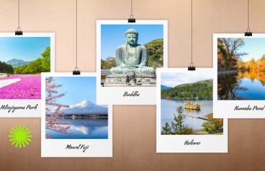
If you are like me, your first trip to Japan probably started off in Tokyo, surrounded by bright neon lights and an astounding number of people moving around to get from place to place. Tokyo is a logical starting point because of the many inexpensive daily flights that arrive, as well as its efficient public transportation, making it very easy to get around and communicate with those whom you meet there, because they speak some English. But let me tell you a little secret I learned from spending two different trips to Japan over the course of three weeks. Although I had fun in Tokyo, I’m definitely not a big progressive city person. The real beauty and the heart of Japan are found away from the chaos of Tokyo. The true essence of Japan can be experienced at its best in either the peaceful mountains high above the sea or in the salty air along the coast of Japan. So if you are planning on staying in Tokyo for more than three days, do yourself a favor and venture outside of the city limits.  These are my favorite day trips from Tokyo. You can travel to each of these destinations within 1 to 2 hours. What Are The Best Day Trips From Tokyo?  Tokyo is an incredible gateway. However, Japan’s true magic is often found in the places where the skyscrapers disappear.  Whether you want the spray of the ocean in Kamakura or the mountain air of Hakone, I promise that leaving the city for just a day will change how you see the country. From Mount Fuji to Kyoto, the Soul of Japan, the day trips from Tokyo are as diverse as they can be.  Here is a detailed account of my experience in those places.  1. Mount Fuji And Kawaguchiko: The Icon Travel Time: 2 Hours  How to Reach There: Highway buses from Shinjuku or Shibuya (~ÂĄ1,250–¥2,000 one way). If I can only recommend one escape, it will be Kawaguchiko, a town located right at the foot of Mt. Fuji.  "Shy" Fuji hides behind a curtain of clouds and can be quite elusive. While I visited, Fuji showed off for me on several occasions. I spent an entire day in this beautiful town, but would recommend an overnight stay at one of the many traditional ryokans situated on the lake if possible. There, you will notice the the juxtaposition of Fuji's reflection on Lake Kawaguchi at sunrise will be a once-in-a-lifetime experience. Highlights From My Visit Climbing the 398 steps of Chureito Pagoda was strenuous. However, the meditation-like calm through the forest made it worthwhile. I was fortunate enough to see the iconic site of the Red Pagoda with Mt. Fuji as a backdrop, as the clouds rolled in and covered the summit of Fuji. HĹŤtĹŤ noodles are a local specialty and are made up of thick, flat noodles cooked in a Japanese miso broth. Eating them will feel like a warm hug! So, don’t forget to try it.  2. Nikko: A Place Of Mist And Masterpieces Travel Time: 2 Hours How to Get There: Tobu Railway from Asakusa to Tobu-Nikko Station. When you visit Nikko, you will see all that it has to offer in the stunning, misty forests and cedar trees. Moreover, the detailed and ornate shrines seem to be jewelry boxes.    Insider Tip:  Arrive before 9 am at Lake Chuzenji to witness how the morning light creates an incredibly peaceful scene on the water.  If you arrive later than 9 am, visit the Toshogu Shrine first, which is where Shogun Tokugawa Ieyasu is buried and features the famous three monkeys, "See no evil, hear no evil, speak no evil". Many people come to see Kegon Falls, but it can be crowded due to the high tourist volume.  Unless you arrive at dawn, I would recommend skipping Kegon Falls and enjoying the calm waters of the lake instead. 3. The Coastal Soul Of Japan: Kamakura Travel Time: 1 hour How to Get There: JR Yokosuka Line from Tokyo Station (ÂĄ940 one way). Kamakura is also popular as the "Kyoto of the East," and I can see why.  Although it is an hour from Tokyo, when you are there, you will be surrounded by the smell of salt and incense from the temples instead of exhaust from busy streets. Be sure to see the Great Buddha (Daibutsu) at Kotoku-in.  This is a large bronze hollow statue located outside.  Standing there, surrounded by trees and soft sea light, I felt a sense of peace and tranquility.  After visiting the Great Buddha, I walked to Yuigahama Beach to watch the surfers and the sunset before enjoying a meal of sukiyaki or shabu-shabu. 4. Hakone: A Breath of Mountain Air Travel Time: 2 Hours How to Get There: Odakyu “Romancecar” from Shinjuku. I recommend the Hakone Free Pass. Tokyo is the pulse of Japanese culture, and it is in Hakone where you'll find peace after the city's frenzied pace. Hakone is a beautiful blend of modern and ancient.  The first stop for my visit was at the Hakone Open-Air Museum, where I walked among sculptures created by some of the most famous artists in the world, surrounded by natural beauty all around me.  Then, I took the Hakone Ropeway across the Owakudani Valley.  It is an active volcanic area where steam rises out of the ground, creating a picture of a living canvas.  On clear days, you may see Mt. Fuji as well.  The day was capped off with a boat ride on Lake Ashi aboard a vessel that resembled a "pirate ship."  I was hesitant about it being cheesy, but the sights were gorgeous. 5. The Easy Escape To Yokohama  Travel Time: 30 Minutes How to get there: JR Tokaido or Keihin-Tohoku Line from Tokyo Station (ÂĄ480). When I need to relax from the chaos of Tokyo, I tend to go to Yokohama.  Yokohama is the 2nd largest city in Japan. However, it has a much more relaxing atmosphere due to the harbor.  I enjoy taking a stroll along Minato Mirai, which is another word for "harbor view," while enjoying the ocean breeze.  For something "quirky", I went to the Cup Noodles Museum to create my own cup of noodles and to learn about the history of Nissin Food Products.  However, the highlight was visiting China Town, which is the largest in Japan.  My recommendation is to arrive at China Town around 4:00 or 5:00 PM.  It will be early enough to beat the dinner rush and late enough to see the entrance of all the glow from the lanterns.  Take a bag of roasted chestnuts and enjoy the view of the skyline from the water while riding on the Cosmo Clock 21 Ferris Wheel. 6. A Trip Back In Time To Kawagoe Travel Time: 1 Hour How to get there: Tobu Tojo Line from Ikebukuro or JR from Shinjuku. If you want a taste of the Edo period without trekking all the way to Kyoto, go to Kawagoe.  It’s a walkable town full of clay-walled warehouses and wooden merchant houses. When I arrived at 8 AM, I heard the Toki no Kane (Bell of Time) tolling in the stillness of the morning.  I went back 200 years in time.  If you have time to go to Candy Alley, everything is made from sweet potatoes, cakes, chips, and even ice cream!  I know it sounds strange, but I assure you that it is really good! 7. Kyoto: The Soul Of Japan Travel Time: 2 Hours (by Shinkansen) How to get there: Tokaido Shinkansen from Tokyo Station (ÂĄ13,320 one way). I usually tell people to stay at least two days in Kyoto, but if a day trip is all you can manage, do it. It is expensive, but it is worth every yen. To appreciate Kyoto fully, you should focus on finding peace and serenity rather than simply marking off temples from a to-do list.  Instead of fighting the crowds at the bamboo groves, I found my peace by sitting in the wonderful gardens of Kennin-Ji Temple and breathing the incense they burned there. 8. Enoshima: Islands And Icons  Travel Time: 2 Hours How to get there: Odakyu Line from Shinjuku to Katase-Enoshima Station. Enoshima is where Japan’s coastal charm meets its spiritual side.  It’s a small island with a bridge and shrines dedicated to the goddess of the sea. Prepare to take many steps as you make your way to Iwaya Caves on the opposite end of the island.  The sound of waves'll surround you as you leave the noise of the city behind.  Furthermore, inside the caves, it’s a different world! After you leave the caves and head back, stop at a vendor and buy some grilled fish or seafood so you can enjoy the smoky aroma of the grilled fish while walking through Enoshima Island. 9. Chichibu: Mountains And Moss Travel Time: 2 Hours How to Get There: Seibu Line from Ikebukuro to Seibu-Chichibu Station. Chichibu is an outdoorsy place if you love the outdoors!  It's got mountains and has a strong cultural heritage.  If your timing is right in the spring, Hitsujiyama Park gets huge patches of pink and white moss phlox in bloom. This area has deliciously filling meals, including miso potatoes and waraji katsu (a pork cutlet that’s named after a straw sandal because of how large it is). 10. Karuizawa: The Alpine Retreat Travel Time: 1 Hour How to get there: Hokuriku Shinkansen from Tokyo Station. Finally, there is Karuizawa. This is where Tokyo’s elite found an escape from the summer heat, and it still feels incredibly sophisticated. Renting a bicycle is one of the best ways to experience this area.  I spent my first morning biking through beautiful pine tree forests until I arrived at Kumoba Pond. The pond has such calm water that it feels like looking into a huge mirror!  In the winter, it turns into a beautiful, snowy retreat perfect for relaxing after spending several days in the city.  Read Also: Is The Japan Rail Pass Worth It In 2026? Should I Buy Or Avoid It As A Conscious Tourist? What Are The Things To Do In Oahu For Free? A Guide For Budget Travelers Festivals Of Light And Color: Experiencing Japan’s Vibrant Matsuri

READ MORE Dunhinda Falls

Dunhinda Falls: The Misty “Bridal Fall” Of Badulla

BY  Sibashree Aug 27, 2026

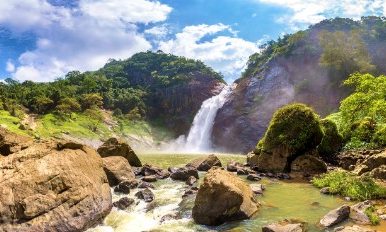
My shoes were soaked when I reached the viewing platform at Dunhinda Falls.   The trail was dry, but the fine spray drifting off the waterfall made my clothes and shoes wet.   So, no wonder the waterfall got its name from this mist.   Also, enjoying a view of this waterfall will be more delightful with the construction of the viewing center at Dunhinda Falls getting started.   This platform will be a replacement for the 50-year-old existing viewing platform, which has been in a deteriorated condition for a long time.   So, as Dunhinda Falls gets decked out with a new platform, I want to share my story and practical details about a visit to it.   What Is The Meaning Of Dunhinda?   The name Dunhinda comes from Sinhala words for mist or smoke. So, the name is a direct reference to the spray that surrounds the base of the falls.  Dunhinda also has another name, “Bridal Falls.” This name comes from the shape of the cascading water, which looks similar to a bridal veil.   The local traditions suggest that the indigenous Veddha people once inhabited the area.   There is also a story about a giant fern becoming lodged at the top of the falls during the reign of King Rajasinghe, damming the water and flooding Badulla town.  Then, a local hero cleared it to protect the town.   Where Is Dunhinda Falls? Dunhinda Falls is at a distance of around 5 Km from Badulla town in the lower central hills of Sri Lanka's Uva Province.  Badulu Oya, running through Badulla itself, has formed this beautiful waterfall. The height of the waterfall is around 64 meters.   Despite not being among the tallest waterfalls in the country, it is one of the most beautiful in the country.   It stands out with its sheer volume and the dramatic mist that it throws up as it crashes into the pool below.   Overall, this waterfall, at a distance of around 243 km from Colombo and 110 km from Kandy, is a natural stop if heading toward or through Badulla on a hill-country route.   How To Reach Dunhinda Falls  From Badulla Town, you can take a tuk-tuk, taxi, or self-driven car to Dunhinda Falls. I took a tuk-tuk, and it took around 15 minutes to complete the journey.   The tuk-tuk cost me around LKR 400, and the route followed the Bandarawela–Badulla road before turning onto the Mahiyangana road toward "Dunhinda Junction," roughly 5 km from Badulla.   If you are coming from Ella, expect the drive to take under an hour, and from Colombo, the Southern Expressway offers the fastest approach before joining the hill-country roads.   Public transport such as buses and tuk-tuks run from Badulla town. However, you will have to wait for a while.   There is a parking area near the trail entrance for those driving themselves.  The Trek To The Falls  The beautiful trek route to the Dunhinda Falls makes it a delightful experience and something beyond a quick photo stop.   From the entrance gate, a forest path of roughly 1 to 1.5 km led to the falls, passing through genuinely lush terrain with birds and butterflies.  Also, I met a few curious monkeys along the way.   The trail was safe, though sections can turn muddy after rain.  So proper footwear matters more here than at some of Sri Lanka's roadside waterfalls.   Along the way, look out for Kuda Dunhinda, or "Small Dunhinda." It is a secondary waterfall visible from a viewpoint on the same path.  What I Found At The Falls? I found an observation platform above the natural pool at the base of the Dunhinda Waterfalls.   Located at the end of the trail, the platform offered a full view of the water dropping through a narrow gap in the rock face before crashing down.  I did not attempt to swim in the pool. The pool has submerged rocks and strong currents in the water.   Also, if you want to have some refreshments, you will find small stalls of snacks, herbal drinks, and simple souvenirs.   Best Photo Spots  The observation platform gives the classic, full-height view of the falls. It is by far the easiest spot to shoot from without getting drenched.   For a slightly different angle, the viewpoint overlooking Kuda Dunhinda partway along the trail offers a quieter composition. Here, you have less spray to contend with.  Overcast mornings tend to produce the most even light for photographing the mist itself.  Harsh sun can blow out the brightest parts of the spray and lose the detail that makes this waterfall distinctive in the first place.  Nearby Attractions Badulla town itself is worth a short visit for its colonial-era architecture and the Muthiyangana Temple, one of the island's older Buddhist sites.   If you have more time, Ella is under an hour away and opens up the wider hill-country circuit, including the Nine Arch Bridge, Ravana Falls, and Little Adam's Peak.   For wildlife-focused travelers, Udawalawe National Park is a feasible day trip from Badulla for those wanting to pair the waterfall with a safari.  Where To Stay Near Dunhinda Falls  Badulla town has a reasonable spread of guesthouses and small hotels.  The options are enough to make it a comfortable overnight base without needing to push on to Ella the same day.   Staying in Badulla also means an early start on the trail before the mid-morning heat and any afternoon rain sets in. It makes for a more pleasant walk through the forest.   Do you want to stay somewhere with more restaurants and traveler infrastructure? Ella is close enough to use as a base instead.  It is ideal for a half-day excursion rather than an overnight stop.  Safety And Practical Notes  The trail, while generally safe and heavily used, does involve some uneven and occasionally muddy footing.  So trainers or light hiking shoes are a better choice than sandals.   Resist the urge to swim in the main pool at the base.  The currents are stronger than they look. There have been drownings here in the past.  That is why the observation platform is the recommended vantage point.   Bring small notes for the entrance fee and any snacks along the trail.  Entrance Fee And Facilities There is an entry fee of LKR 200 payable at the gate before the trail begins. Also, there are basic toilet facilities and a parking area for those arriving by vehicle.   The fee structure is modest. It goes toward maintaining the path and the observation platform at the base.   There is no formal visitor center.  Best Time To Visit The Dunhinda Falls   The waterfall changes its character with the seasons.   June and July are the safest months, when trail conditions are dry.   However, in the wetter months, particularly from around November to March, the falls are at their most dramatic and full.  The trek itself gets muddier.   If your priority is photography and volume, aim for right after the rain. However, if it is a comfortable walk, the mid-year months are the best.  Also, early mornings from 7 AM to 8:30 AM and late afternoons from 4 PM to 5:30 PM are the best.