
Dunhinda Falls: The Misty “Bridal Fall” Of Badulla

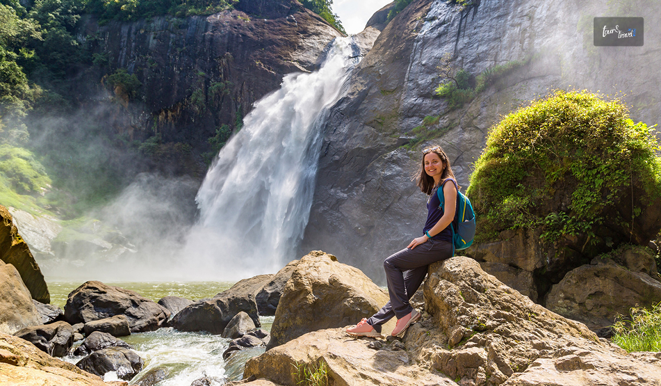
My shoes were soaked when I reached the viewing platform at Dunhinda Falls.  

The trail was dry, but the fine spray drifting off the waterfall made my clothes and shoes wet.  

So, no wonder the waterfall got its name from this mist.  

Also, enjoying a view of this waterfall will be more delightful with the construction of the viewing center at Dunhinda Falls getting started.  

This platform will be a replacement for the 50-year-old existing viewing platform, which has been in a deteriorated condition for a long time.  

So, as Dunhinda Falls gets decked out with a new platform, I want to share my story and practical details about a visit to it.  

What Is The Meaning Of Dunhinda?  

The name Dunhinda comes from Sinhala words for mist or smoke. So, the name is a direct reference to the spray that surrounds the base of the falls. 

Dunhinda also has another name, “Bridal Falls.” This name comes from the shape of the cascading water, which looks similar to a bridal veil.  

The local traditions suggest that the indigenous Veddha people once inhabited the area.  

There is also a story about a giant fern becoming lodged at the top of the falls during the reign of King Rajasinghe, damming the water and flooding Badulla town

Then, a local hero cleared it to protect the town.  

Where Is Dunhinda Falls?

Dunhinda Falls: The Misty “Bridal Fall” Of Badulla

Dunhinda Falls is at a distance of around 5 Km from Badulla town in the lower central hills of Sri Lanka’s Uva Province. 

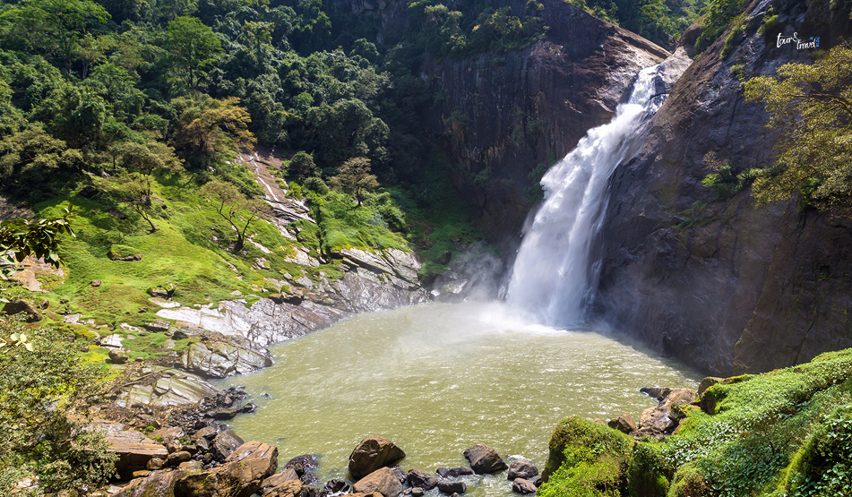
Badulu Oya, running through Badulla itself, has formed this beautiful waterfall. The height of the waterfall is around 64 meters.  

Despite not being among the tallest waterfalls in the country, it is one of the most beautiful in the country.  

It stands out with its sheer volume and the dramatic mist that it throws up as it crashes into the pool below.  

Overall, this waterfall, at a distance of around 243 km from Colombo and 110 km from Kandy, is a natural stop if heading toward or through Badulla on a hill-country route.  

How To Reach Dunhinda Falls 

From Badulla Town, you can take a tuk-tuk, taxi, or self-driven car to Dunhinda Falls. I took a tuk-tuk, and it took around 15 minutes to complete the journey.  

The tuk-tuk cost me around LKR 400, and the route followed the Bandarawela–Badulla road before turning onto the Mahiyangana road toward “Dunhinda Junction,” roughly 5 km from Badulla.  

If you are coming from Ella, expect the drive to take under an hour, and from Colombo, the Southern Expressway offers the fastest approach before joining the hill-country roads.  

Public transport such as buses and tuk-tuks run from Badulla town. However, you will have to wait for a while.  

There is a parking area near the trail entrance for those driving themselves. 

The Trek To The Falls 

The beautiful trek route to the Dunhinda Falls makes it a delightful experience and something beyond a quick photo stop.  

From the entrance gate, a forest path of roughly 1 to 1.5 km led to the falls, passing through genuinely lush terrain with birds and butterflies. 

Also, I met a few curious monkeys along the way.  

The trail was safe, though sections can turn muddy after rain. 

So proper footwear matters more here than at some of Sri Lanka’s roadside waterfalls.  

Along the way, look out for Kuda Dunhinda, or “Small Dunhinda.” It is a secondary waterfall visible from a viewpoint on the same path. 

What I Found At The Falls?

Dunhinda Falls: The Misty “Bridal Fall” Of Badulla

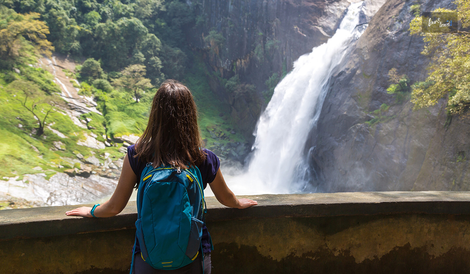
I found an observation platform above the natural pool at the base of the Dunhinda Waterfalls.  

Located at the end of the trail, the platform offered a full view of the water dropping through a narrow gap in the rock face before crashing down. 

I did not attempt to swim in the pool. The pool has submerged rocks and strong currents in the water.  

Also, if you want to have some refreshments, you will find small stalls of snacks, herbal drinks, and simple souvenirs.  

Best Photo Spots 

The observation platform gives the classic, full-height view of the falls. It is by far the easiest spot to shoot from without getting drenched.  

For a slightly different angle, the viewpoint overlooking Kuda Dunhinda partway along the trail offers a quieter composition. Here, you have less spray to contend with. 

Overcast mornings tend to produce the most even light for photographing the mist itself. 

Harsh sun can blow out the brightest parts of the spray and lose the detail that makes this waterfall distinctive in the first place. 

Nearby Attractions

Dunhinda Falls: The Misty “Bridal Fall” Of Badulla

Badulla town itself is worth a short visit for its colonial-era architecture and the Muthiyangana Temple, one of the island’s older Buddhist sites.  

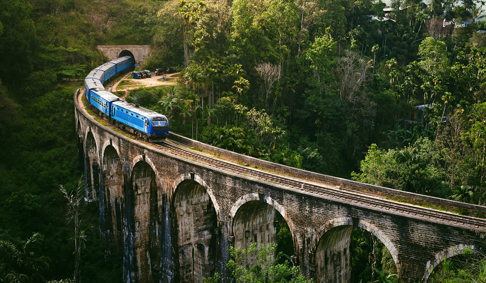
If you have more time, Ella is under an hour away and opens up the wider hill-country circuit, including the Nine Arch Bridge, Ravana Falls, and Little Adam’s Peak.  

For wildlife-focused travelers, Udawalawe National Park is a feasible day trip from Badulla for those wanting to pair the waterfall with a safari. 

Where To Stay Near Dunhinda Falls 

Badulla town has a reasonable spread of guesthouses and small hotels. 

The options are enough to make it a comfortable overnight base without needing to push on to Ella the same day.  

Staying in Badulla also means an early start on the trail before the mid-morning heat and any afternoon rain sets in. It makes for a more pleasant walk through the forest.  

Do you want to stay somewhere with more restaurants and traveler infrastructure? Ella is close enough to use as a base instead. 

It is ideal for a half-day excursion rather than an overnight stop. 

Safety And Practical Notes 

The trail, while generally safe and heavily used, does involve some uneven and occasionally muddy footing. 

So trainers or light hiking shoes are a better choice than sandals.  

Resist the urge to swim in the main pool at the base. 

The currents are stronger than they look. There have been drownings here in the past. 

That is why the observation platform is the recommended vantage point.  

Bring small notes for the entrance fee and any snacks along the trail. 

Entrance Fee And Facilities

Dunhinda Falls: The Misty “Bridal Fall” Of Badulla

There is an entry fee of LKR 200 payable at the gate before the trail begins. Also, there are basic toilet facilities and a parking area for those arriving by vehicle.  

The fee structure is modest. It goes toward maintaining the path and the observation platform at the base.  

There is no formal visitor center. 

Best Time To Visit The Dunhinda Falls  

The waterfall changes its character with the seasons.  

June and July are the safest months, when trail conditions are dry.  

However, in the wetter months, particularly from around November to March, the falls are at their most dramatic and full. 

The trek itself gets muddier.  

If your priority is photography and volume, aim for right after the rain. However, if it is a comfortable walk, the mid-year months are the best. 

Also, early mornings from 7 AM to 8:30 AM and late afternoons from 4 PM to 5:30 PM are the best.

Share on Social Media

Sibashree is a travel, culture, and leisure writer who has been writing since the age of 12 and professionally since 2014. With more than a decade of travel writing experience and journeys across India and several parts of the world, she brings a deeply personal and thoughtful perspective to her work. A student of English Literature and Mass Communication, Sibashree has always viewed travel as more than movement — for her, it has been a way of understanding people, cultures, and herself. Her passion for spiritual exploration has also led her to many unusual and meaningful destinations over the years. Outside of writing, Sibashree enjoys watching European cinema, reading about global politics, and reflecting on the stories hidden within everyday places.

Leave a Reply

Your email address will not be published. Required fields are marked *

title-img Related

READ MORE world's end sri lanka

World’s End, Sri Lanka: Chasing the View Before the Clouds Roll In

BY  Sibashree Aug 31, 2026

Nobody tells you how early a '5 AM start' actually feels until you are standing in the dark outside your Nuwara Eliya guesthouse, breakfast pack in hand, waiting for a tuk-tuk.   But that is the deal with World's End.  The view is clear from about 9 AM to 10 AM.  After that, clouds roll in off the valley and swallow the whole thing whole.   I had heard this enough times before arriving that I did not question the alarm. And I am glad I did not.  By the time I reached the escarpment, the drop in front of me was still clear enough to see the coast, some 80 kilometres away.  World's End is a sheer escarpment inside Horton Plains National Park, in Sri Lanka's central highlands.   You have to take a circular hiking trail to reach it, and the same route also takes you to Baker's Falls and a smaller companion viewpoint called Mini World's End.  It has become one of the most-hiked routes in the country precisely because the effort-to-reward ratio is so favourable.  It is a manageable walk for a view most people only expect to earn after a serious trek.  World’s End, Sri Lanka: At A Glance  Location Horton Plains National Park, central highlands  Elevation at start About 2,100 metres  Drop at World's End Approximately 870–880 metres  Circular trail distance 9–9.5 km (Red Bridge → Mini World's End → World's End → Baker's Falls → back)  Typical hike duration 2.5–4 Hours  Park hours 6 AM to 6 PM  Best time to visit January to March (Driest Months). You must arrive by 6 AM regardless of season.  Nearest base Nuwara Eliya   Why The Early Start Actually Matters This is not exaggerated marketing. World's End genuinely clouds over by mid-morning most days, often as early as 9 AM.  The park opens at 6 AM, and the guidance from pretty much every guide, driver, and fellow hiker I spoke to was the same.  Get there at opening, start walking immediately, and don't dawdle at Mini World's End if clear skies at the main viewpoint are your priority.   I reached World's End a little under an hour and a half after setting off and had maybe twenty clear minutes before the first wisps of cloud started drifting up from the valley below.  There is no public transport directly to Horton Plains from Nuwara Eliya.  So you are looking at a hired tuk-tuk, car, or a pre-booked tour.  The PickMe app works if you would rather arrange it yourself the night before.   Whatever you choose, the pre-dawn logistics are worth planning a day ahead, since most hotels won't have breakfast ready at 4:30 AM and will instead hand you a packed breakfast to eat on the trail.  The Hike Itself The full loop runs roughly 9 to 9.5 kilometres and is considered moderate rather than difficult.  It is mostly flat with some gentle inclines.   It is well-marked, and it is notably the only national park in Sri Lanka where you are allowed to walk the trail without a mandatory guide.   From the Red Bridge entrance, it is about 2 kilometres to Mini World's End.  Then on to the main viewpoint, before the trail loops back via Baker's Falls, one of the widest waterfalls in the country, and a good spot to slow down once the pressure of beating the clouds is behind you.  Along the way, expect sambar deer grazing close to the trail.  They are genuinely unbothered by hikers here.  I also spotted purple-faced langurs, giant squirrels, and a decent range of highland birdlife.   Leopards are present in the wider Horton Plains area, but sightings are rare enough that I would not build any expectations around it.  Mini World's End Vs. The Main Event  It is easy to treat Mini World's End as a warm-up and rush past it.  However, it is worth a few minutes on its own terms.  A smaller drop, fewer people at that hour, and in some ways a calmer view than the more crowded main viewpoint!  Some hikers reverse the usual direction of the loop specifically to hit World's End last rather than first.  Either way works, but going clockwise from Red Bridge (Mini World's End, then World's End, then Baker's Falls) is the standard and the one most guides default to.  Planning Your Visit World's End earns its reputation honestly.  It is one of the few views in Sri Lanka that lives up to the hype, provided you respect the clock.   The hike itself is forgiving enough for most fitness levels.  Also, the wildlife along the way is a pleasant bonus, and the payoff at the escarpment, on a clear morning, is the kind of view that makes the 5 AM alarm feel like a fair trade.  Entry Fees  Expect to pay in the region of USD 20–25 per foreign adult visitor. Also, you will have to pay a separate vehicle fee if you are driving or being driven in.  The total for a couple with a hired tuk-tuk can run well over what the headline entry fee alone suggests. Fees are collected in USD or LKR at the park entrance.  What To Pack  Pack layers as it is cold enough at 2,100 metres before dawn to want a proper jacket. However, you will likely be down to a T-shirt by mid-hike.   Add sturdy shoes, water, the breakfast pack, and a hat for once the sun burns through.   The terrain does not demand technical gear, but the temperature swing from predawn to midday catches people out.  Best Time Of Year  January to March is generally the driest and most reliable stretch for clear views.  However, the daily mist pattern matters more than the season.  Even in the driest months, arriving after 9 AM risks losing the view entirely. An early start in a wetter month can still pay off.  Where This Fits In A Sri Lanka Itinerary  World's End is a natural pairing with a Nuwara Eliya stay. It is often combined with tea estate visits, Adam's Peak, or the train journey onward to Ella.   Given the early start and 3–4-hour round trip, I would treat it as a dedicated half-day rather than trying to combine it with much else that same morning.  By the time you are back at the entrance, most of the day's clear-view window has already closed anyway.

READ MORE Habarana

Why Is Habarana Beyond Just A Gateway To The Cultural Triangle Of Sri Lanka?

BY  Sibashree Apr 27, 2026

Search for Habarana on Google, and in 9 out of 10 cases, it will show that Habarana in North-Central Sri Lanka is the base for visiting the cultural triangle of Sri Lanka.  However, Habarana in the district of Anuradhapura in itself is a perfect blend of adventure, culture, and nature.  So, if you want to set your cultural itinerary in Sri Lanka right, Habarana will be at the epicenter. In this article, I will talk about the things to do in Sri Lanka from Habarana. I will also discuss the top attractions in this beautiful tourist town with a population of 5000.  Where Is Habarana?  Habarana in Anuradhapura District is around 180 km away from Colombo, the capital of Sri Lanka.  Located in the north-east of Colombo, it is also just 30 minutes away by road from the Sigiriya Rock Fortress, a UNESCO World Heritage Site, and its neighbor, Pidurangala Rock.  How To Reach Habarana?  The most convenient way to reach Habarna is to take a bus or train from Trincomalee.  I, of course, as always, opted for a train ride after a visit to the Uppuveli Beach and exploring the other things to do in Trincomalee.  Getting To Habarana On A Train  The Habarana Railway Station is on the Colombo to Trincomalee Railway Line. I took a night train from Trincomalee (Night Mail, Trincomalee → Colombo Fort).  This train runs daily and departs the Trincomalee Station at 7 PM and reaches Habarana at 9:30 PM.  I bought a second-class ticket, and it cost me 800 LKR. The third-class tickets will cost around LKR 600.  Getting To Habarana On A Bus  From Trincomalee to Habarana, it is a bus ride of little over 2 hours. The ticket price was INR 300 when I last enquired.  You will get different buses run by the Sri Lanka Transport Board and many private buses.  However, considering the scorching Sun of Sri Lanka, a bus ride is difficult in the daytime, and the Trincomalee to Habarana route remains crowded. Why Is Habarana The Base For A Cultural Exploration In Sri Lanka?  Habarana has a beautiful lake by the name of Habarana Lake. It is a tranquil water body with lush greenery around.  It is a beautiful place for birdwatching. Furthermore, you can also spot monkeys and elephants here.  When you are in Habarana, you can start your day with a stroll along the lake. Then, you can plan a day trip to the following places.  1. The Sacred City Of Anuradhapura  Distance from Habarana: 59 Kms The Sacred City of Anuradhapura is a UNESCO World Heritage Site. It was the religious and cultural capital of Sri Lanka for 1300 years.  However, it was massively impacted due to the invasion in 993 AD.  The main stupas in this sacred complex are the Abhayagiri Vihara Stupa, Jethawanaramaya Stupa, the third-largest man-made structure, and the most sacred Ruwanwelisaya Stupa.  2. Kaudulla National Park  Distance from Habarana: 28 Kms If you want to spot elephants in Sri Lanka, you have to visit the Kaudulla National Park.  However, the Kaudulla National Park is not just about the safaris or spotting the wildlife. During my visit, I found it truly living up to its reputation for animal welfare.  It is one of the places I visited where elephants are not chained.  3. Hurulu Eco Park  Distance from Habarana: 3.4 Kms The Hurulu Eco Park is the closest destination to visit from Habarana if you want to experience the wildlife of Sri Lanka.  Elephants passing between the Minneriya National Park and the Kaudulla National Park use Hurulu Eco Park as an important corridor.  Moreover, the topography of the Hurulu Eco Park is a good mix of plains, rocks, and evergreen jungle.  4. Dambulla Royal Cave Temple Distance from Habarana: 25 Kms The Dambulla Royal Cave Temples are fascinating, and being a two-million-year-old place of Buddhist worship is something extraordinary.  The more amazing thing is that the temples are well-preserved, and people still worship Lord Buddha in these temples.  Spanning an area of 2100 square meters, these cave temples have 157 statues of Lord Buddha and other important figures of Buddhism.  However, among all these statues, the reclining statue of Lord Buddha in the 1st cave will remain etched in my memory forever.  5. Ritigala Forest Monastery Distance from Habarana: 21 Kms The Ritigala Forest Monastery has its historical roots in the 1st century BCE. During that time, Buddhist monks settled here.  Over time, this monastery became an important site for the powerful Pansukulika Sect, which enjoyed the highest form of glory during the 9th to 11th centuries.  However, it was destroyed by Chola invasions in the 10th-12th centuries.  The Ritigala Forest Monastery has a long history of discovery and restoration, too. Moreover, it has a connection with the great Hindu epic, the Ramayana.  In addition, the Ritigala Mountain is home to more than 417 species of medicinal plants and a rich biodiversity. 6. Sigiriya Rock Fortress  Distance from Habarana: 30 Kms The Sigiriya Rock, a UNESCO World Heritage Site, is primarily a site of a Buddhist monastery from the 3rd to 1st century BCE. However, there are also legends about this rock fortress being the Golden Palace of Ravana.  Nevertheless, the Buddhist monastery in the Sigiriya Rock rose to importance when Anuradhapura became the capital of Sri Lanka. 7. Pidurangala Rock Distance from Habarana: 30 Kms Many tourists make the mistake of considering Pidurangala Rock as a trekking point that offers a better view of the Sigiriya Rock.  However, along with being a neighbor of Sigiriya Rock, it also has a history of Buddhism associated with it, and the history is 2 millennia old.  After Kashyapa made the Sigiriya Rock the center of power, the monks shifted from there and started residing in the Pidurangala Rock.  It also received royal patronage for its development and for making adequate accommodations for the monks here.  8. The Ruins Of Polonnaruwa Distance from Habarana: 47.5 Kms The ruins of Polonnaruwa are a part of the cultural triangle of Sri Lanka. Polonnaruwa was a growing religious and commercial center of Sri Lanka for over 800 years.  During the Sinhalese and Chola kingdoms and for three centuries, it was the capital of the country.  Today, the Ancient City of Polonnaruwa has the ruins of the Royal Palace, the Sacred Quadrangle, the central dagoba, Shiva Devale, Pabalu Vehera, Rankot Vihara, the dagaba Kiri Vihara, and many other ruins and architecture.  Also, the Buddha sculptures in different dagobas or stupas of the complex were mesmerizing.  9. Minneriya National Park  Distance from Habarana: 5.8 Kms Minneriya National Park has a lush landscape, and along with elephants, it is also home to diverse wildlife such as sloth bears, leopards, and different bird species.  The annual gathering of elephants is the most fascinating incident of the Minneriya National Park. It indicates an event where hundreds of elephants have a meeting, or they gather around the Minneriya Tank.  Habarana: Beyond The Gateway To The Cultural Triangle Of Sri Lanka   Although most people think of Habarana as being nothing more than a bus stop for those heading to Sigiriya or Polonnaruwa, it actually turned out to be the best surprise during my trip to Sri Lanka.  The only reason to stay in Habarana is how convenient the location is.  However, staying there provided me with an experience that you couldn’t reproduce in the more touristy areas of the island, which is the natural beauty of the area. A Place For The Gentle Giants The highlight of my time spent in Habarana was the fact that I was so close to Minneriya and Kaudulla National Parks.  I didn’t just see elephants. I witnessed what is known as the "Gathering."  Also, I observed hundreds of wild elephants gathered around one of the ancient reservoirs while driving around in an open-top jeep.  This is due to it being located in the middle of these two migratory areas.  While we still had wildlife encounters in the more touristy areas, they didn’t have the same natural feel or take the same amount of effort as they did while driving around in Habarana. Authentic Village Immersion In addition to going on safari, I spent a morning enjoying the lifestyle of the people living on the shores of a local lake.  I took a traditional horse-drawn carriage to the lake and paddled across the lake in a canoe.  I shared a meal of rice and spicy sambol with a family in their mud hut that was about as authentic as you could get.  This was far more than just a stopping point, and it was an example of the hospitality of the Sri Lankan people and the slow lifestyle that became my takeaways. Where To Stay In Habarana?  If you're looking for accommodations in Habarana, you're sure to find something that meets your budget, with options ranging from "basic backpacker" to "boujie boutique" accommodations.  For a "calm little oasis," Dudley's Nature Resort is a great option, and it is located 15 minutes away from the main strip of Habarana. Furthermore, the resort is set in a lush jungle environment and includes a pool and breakfast served in the garden.  Moreover, if you are looking to be in a social environment, Roy's Villa Hostel is close by and has an incredible communal atmosphere. Where To Eat In Habarana?  For authentic local flavors, Dewata Villa is a must-visit for its legendary "Rice & Curry" spread.  If you're looking for a quick, budget-friendly bite, Cinnamon Lodge offers great snacks, while the main street is lined with "Short Eat" bakeries for spicy pastries.  For a more social evening, head to Roy’s Villa nearby for delicious communal dinners and great vibes.

READ MORE Beruwala

Beruwala Beach And More: Where Sri Lanka’s Southwest Coast Meets A Thousand Years Of History

BY  Sibashree Aug 8, 2026

I got the whiff of Beruwala even before I reached it.  While Bentota is a glossier neighbor in the south, Beruwala seemed more significant to me.  I found it more appealing because it once again highlighted the inclusive nature of Sri Lanka.  If Jaffna is the hub of Hindu temples and Tamil Culture, Beruwala is the place where Islam first took root in Sri Lanka.  Also, as a coastal town, it has been welcoming pilgrims, traders, and sailors for more than a thousand years now.  All these make Beruwala an important spot on the southwest coast of Sri Lanka, and in this article, I will discuss my experience there, Beruwala Beach, things to do, and more.  Beruwala: A Harbor With A Long Memory  Beruwala had the first multi-day fishing boat launching yard in Sri Lanka on 11th June, 2026.  It will promote the boat manufacturing industry of Sri Lanka. The boat manufacturing industry will be a leading export sector in the economic development of Sri Lanka in the future.  While this is a new feather added to the crown of Beruwala, it already has a long history as a harbor.  The name Beruwala itself has a Sinhalese origin, meaning “Lowering the Sail.” So, it functioned as a national anchorage since anyone even knew about it.  According to local history, the Arab traders landed here in the 8th century. They used this sheltered bay as a stopover on their trade routes across the Indian Ocean.  They came for gems, spices, and pearls, and some of them stayed. The Settlement Of The Moor Community  The first wave of settlement in Beruwala marked the beginning of the Sri Lankan Moor community. This community, or the Sri Lankan Muslims, can trace back their origin to the early Arab arrivals. Over the centuries, many intermarriages happened, and the community thrived.  Today, Beruwala remains one of the cultural centers of that community, and you feel it the moment you walk through town. You will hear the call to prayer drifting over the harbor, halal eateries lining the main road, and a rhythm of life that is different from most coastal areas in the stretch.  What Are The Things To Do In Beruwala?  I spent my first morning at the fishing harbor, the heart of the town.  If you can be here before 7 AM, you will see outrigger canoes and small trawlers come in loaded with the night's catch. Also, fishermen wearing wide-brimmed hats haul their nets while gulls circle overhead.  Yes, it is chaotic, but nothing is staged here. That authenticity or rawness stays with you.  Furthermore, the harbor of Beruwala is the main supplier of fresh seafood across the region. However, to be that, the fishermen did not have to leave everything old behind.  From the looks of the boats, they look like they have not been changed for generations. So, watching the fishermen sailing or working in the boats felt like being at a museum that preserves the working identity of this coastal town.   While you can spend an entire day at the fishing harbor, there are many attractions in Beruwala. So, let’s discuss the things to do.  1. A Visit To The Kechimalai Mosque And The Headland From the harbor, I took a short walk to Kechimalai Mosque. It is on the northern promontory where the earliest Arab-Muslim settlers first came ashore, according to local traditions.  There is a little confusion, though, about the origin or age of the mosque. Still, the popular opinion is that it was built between the 11th and 13th centuries.  The mosque has a humble architecture with pale walls, a modest dome, and arched windows facing the sea. Some parts of the mosque further reflect later renovations from the colonial period. Even if you do not want to enter the mosque, you can cherish the view of the harbor and open sea beyond it from the headland.  I was thrilled to know that it was the same vantage point sailors would have used a thousand years ago to judge the weather before setting out.  Moments like this ground you and help you connect with history.  2. Visiting The Masjid Al Abrar  Masjid Al Abrar is very close to the Kechimalai Mosque, and it is one of the oldest mosques in the country.  These two mosques and the smaller mosques scattered through the town carry an Islamic heritage that few other places on this coast can match,  3. Exploring The Beaches My beach experience in Beruwala started with Moragalla Beach. It was just north of the main town.  It won me over with its calmness, and it was uncrowded. So, I could do what I love the most, watching people.  I saw the fishermen working the shallows in the early morning.  The water here is gentle enough for casual swimming and decent snorkeling if you catch it on a clear day. Closer to the hotel strip, the main Beruwala beach stretches out with the kind of golden sand that made this coast famous in the first place. It is more developed, with resorts backing directly onto the shore, but it's still noticeably quieter than Bentota or Hikkaduwa further south.  Watersports In Beruwala Beach  If you are after watersports, this is also where you'll find operators offering jet skiing, parasailing, and diving trips out toward the reefs.  Beruwala and Bentota together form one of the more established watersports hubs on the southwest coast. Just offshore sits Barberyn Island, marked by its lighthouse, which makes for a nice reference point if you're out on the water or just watching the horizon from a beachfront restaurant at sunset. 4. Exploring The Food, Markets And China Fort Legacy  Beruwala has the best seafood in Sri Lanka, and it is tied to the identity of the town.  I had some of the best deviled prawns of my entire trip at a small place a few minutes' walk from the fish market. Furthermore, the fish curry I had here had a prominent presence of tamarind, and it was very different from what I ate in Jaffna and other parts of the north.  Once again, the prawn fritters or Isso wade was a good street-side snack, and you want to just chill and watch the fishermen in action.  5. Knowing Beruwala As A Gem-Trading Hub Beruwala has a famous history of gem trading. The historical landmark of China Fort here was the place from where the gem traders used to operate.  The China Fort Gem Tower still has many jewelry and handicraft shops. You will also find similar shops around the town.  Even if you are not buying something from these shops, you must browse them.  It will be a great experience to know how central trade once was to the town's economy. Reaching Beruwala And Getting Around  Beruwala is just 60 km south of Colombo, and you will find it along the A2 coastal highway.  If you are traveling from Colombo, you can take a car or taxi or travel by bus and train.  1. Reaching Beruwala By Taxi Or Car Despite a distance of just 60 km, a private car rental or taxi service from Colombo to Beruwala will be around LKR 13000.  The higher range can reach around LKR 22000 based on the type of vehicle you are hiring.  Considering the high cost, it is best to combine a trip to Beruwala with other coastal stops.  How To Combine A Trip To Beruwala From Colombo With Other Coastal Stops? Route SegmentApproximate Driving Time (Coastal Road)Best Known ForColombo ➔ Kalutara1 HourStupas and Historic CastlesKalutara ➔ Beruwala20 MinutesFishing Port and Muslim HeritageBeruwala ➔ Bentota10 MinutesJet Skiing and Mangrove River SafariBentota ➔ Kosgoda15 MinutesSea Turtle HatcheriesKosgoda ➔ Hikkaduwa30 MinutesSnorkelingCoral ReefsNightlifeHikkaduwa ➔ Galle35 MinutesColonial Fort ArchitectureShopping  2. Reaching Beruwala By Train If you are traveling from Colombo Fort to Beruwala by train, the journey of around 54.33 km takes around 1 hour and 20 minutes.  Furthermore, the 1st class ticket costs LKR 500, the second-class ticket costs LKR 300, and the third-class ticket costs LKR 140.  3. Beruwala By Bus  You can get buses from the Bastian Mawatha Terminal of Combo regularly to Galle. These buses run along the A2 Highway.  The buses take around 2 hours to complete the journey. Also, the ticket price for regular bus services is LKR 235, and the ticket prices for AC buses are LKR 390.  4. Getting Around Beruwala  Tuk-tuks are the best option to explore Beruwala and other nearby coastal areas. You can also reserve a tuk-tuk for half-day sightseeing.  The cost is slightly higher here, and the amount will be around LKR 4000.  Why Beruwala Is Absolutely Worth It  A coastal town with a history of 1000 years! If that is the tagline for Beruwala, it is absolutely worth a visit.  Also, it is a working fishing harbor and a stretch of genuinely good beach all sit within walking distance of each other. So, if you are planning a southwest coast itinerary, don't just let Beruwala be the town your bus passes through on the way to Bentota or Galle. Give it a morning, at least.