
Mulkirigala Raja Maha Vihara: Know The Dambulla Of The South Or Little Sigiriya

I was confused when I first heard about Mulkirigala. Some called it the Dambulla of the South because of its multi-level cave complex structure. 

Also, some called it Punchi Sigiriya or Little Sigiriya because of the massive natural rock outcrop and the vertical cliffs resembling the Sigiriya Rock Fortress

Furthermore, to be honest, Mulkirigala was not on the bucket list I had before flying into the deep south of Sri Lanka.

I was more interested in Mirissa’s whale-watching boats and Hiriketiya’s crescent bay.

However, a guesthouse owner in Dikwella insisted that I must visit this rock temple older than Sigiriya. 

It was just forty minutes inland, and I could expect it to be way less crowded than the Dambulla Royal Cave Temple

That combination of history and near-total quiet attracted me. This combination is rare in the tourist circuit of Sri Lanka. 

So, I could not help rearranging one morning around the spot. 

As a reward, I could explore a working monastery carved into and around a 205-meter granite outcrop. 

It had cave shrines and murals from the Kandyan era. 

Also, it had a stone staircase climbing through five distinct terraces to a stupa with views over the Hambantota jungle canopy

In this article, I will discuss what I found at Mulkirigala Raja Vihara, what it costs, and what it takes to get there now. 

There are also some heartfelt inputs about why I feel it deserves a place on more southern-coast itineraries than it currently gets.

Mulkirigala Raja Vihara At A Glance

DetailInformation
Full nameMulkirigala Raja Maha Vihara (also spelled Mulgirigala)
Local nicknamePunchi Seegiriya (“Little Sigiriya”)Dambulla of the South
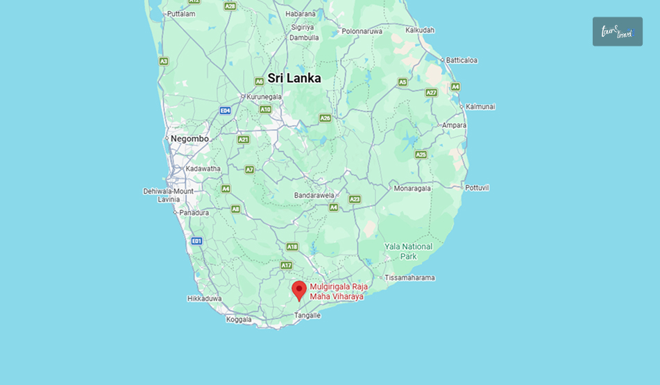
LocationMulkirigala village, Hambantota District, Southern Province
Rock heightAbout 205 metres (673 ft) above the surrounding plain
OriginsTraced to the 3rd century BCRecorded in the chronicle Bodhi Vamsa as “Giriba Vihara.”
StructureFive terracesSeven cave shrinesGranite stairways to climb up
Nearest townsAbout 2 km from Mulkirigala Junction.Reachable from Beliatta, Dikwella, or Tangalle
Protected statusDeclared an archaeological protected monument (Gazette No. 501, 8 April 1988)

A Temple Older Than Sigiriya, And Quieter Too

Mulkirigala predates Sigiriya. 

Long before Kashyapa built his fortress-palace in the 5th century AD, this rock was already a site of Buddhist worship.

It stayed in continuous use through the Anuradhapura, Polonnaruwa, and Kandyan periods. 

The temple I actually walked through, including the murals, the seated and reclining Buddha statues, and the ceiling paintings, mostly date to an 18th-century restoration.

Kandyan king Kirti Sri Rajasinha led this restoration work after the prolonged disrepair, following the reign of Parakramabahu the Great.

The current entrance fee is a modest 500 Sri Lankan rupees for foreign visitors. Additionally, if you are driving or traveling in a car for a round trip, the parking fee will be LKR 100. 

How To Reach Mulkirigala Raja Vihara?

How To Reach Mulkirigala Raja Vihara

Mulkirigala sits inland from the coastal belt between Tangalle and Matara.

So, it is an easy half-day detour from any of the beach towns in that stretch rather than a destination requiring its own overnight stay.

From Tangalle Or Dikwella

This is the most common route to reach Mulkirigala, and I traveled from Dikwella. 

It was a tuk-tuk ride of around 40 minutes, and it was alongthe  Beliatta–Weeraketiya road.

The tuk-tuk turned off at Mulkirigala Junction and continued for around 2 km to the base of the Mulkirigala Raja Vihara. The tuk-tuk charged me around LKR 2700. 

I opted for a half-day hire along with waiting time. 

Here, the exact fare of the tuk-tuk will depend on your negotiation skills and waiting time. 

From Mirissa, Weligama, Or Matara

If you are staying further up the coast, both Tangalle and Dikwella are accessible via the Southern Expressway.

So, Mulkirigala is an easy stop on a day loop that also takes in Dikwella’s Blue Beach or the Hoo-maniya blowhole. 

A hired car or tuk-tuk for the day is the practical option, as there is no direct public bus to the temple itself.

You will get a bus only to Beliatta town, from where a three-wheeler covers the last stretch.

Climbing The Five Terraces

The site is organized into five ascending sections.

The climb is a mix of stone stairways and short paved paths. So, it took me a little over an hour up, with time to linger in each shrine, plus a shorter descent.

TerraceWhat’s There
Patha Maluwa (Lower Terrace)Ground-level entrancePilgrim’s rest areaMonks’ quarters (Sanghavasa)And the small site museum
Bodhi Maluwa (Bodhi Tree Terrace)The Bodhi tree has grown from one of the 32 original saplings of Anuradhapura’s Jaya Sri Maha Bodhi.
Raja Maha Vihara Maluwa (King’s Temple Terrace)The main cluster of cave shrines, with reclining, seated, and standing Buddha statues and 18th-century murals.
Uda Bodhi Maluwa (Upper Bo Tree Terrace)A second Bodhi tree terrace partway up the rock, a natural resting point before the final climb.
Chaitya Maluwa (Stupa Terrace)The summit stupa and open rock platform, with panoramic views over the Hambantota jungle and, on clear days, toward the coast.

The Discovery Of The Vamsatthappakasini Or Mahawamsa Tika In The Cave Temple

In one of the caves on the upper terraces was the place where British civil servant George Turnour discovered palm-leaf manuscripts of  Vamsatthappakasini or Mahawamsa Tika in 1826 to 1827. 

It made the translation of the Mahawamsa Tika possible, making the great historical chronicle of the island more accessible. 

I was standing in that cave. It was dim and cool and felt comforting after the heat of the open stairways. 

However, when I heard about the discovery and its significance, I felt like I was standing inside a footnote of how Sri Lankan history actually got written down.

Also, the Dutch called the same cave “Adam’s Berg,” as they believed it held the tombs of Adam and Eve. 

The Murals Of  Mulkirigala Raja Maha Vihara And What Makes Them Different

Dambulla and Mulkirigala caves felt similar in structure, with reclining and seated Buddhas against painted walls and ceilings.

However, the palette and iconography here were different. 

Several shrines in the cave temple have a mix of Hindu deities and motifs alongside the Buddhist imagery. 

These once again indicate the layered past of the cave temple. 

Also, with these Hindu images, the cave temple shows long, continuous use across different periods of patronage rather than a single unified building campaign.

The murals as they stand today mostly belong to the Kandyan-era restoration. They have flat perspective, bold outlines, and an ochre-and-blue palette typical of royal temple painting from that period.

Moreover, the caves here are smaller than Dambulla. 

I spotted around a dozen other visitors across the entire site during the two hours I spent there. 

Practical Information For Visiting The Mulkirigala Raja Maha Vihara

Things to KnowDetails
Entrance Fee (Foreigners)Approximately LKR 500 Per Person
Opening HoursGenerally Dawn to Dusk
Most Visitors Arrive between 8:00 AM and 4:00 PM.
FootwearTake Your Shoes and Hats off at Every Shrine.
Expect to Walk Parts of the Site Barefoot on Warm Stone.
Dress codeKeep Your Shoulders and Knees Covered.
GuidesInformal Guides often Approach Near the Entrance
Agreeing a Fee Upfront is Optional but Common.
WildlifeResident Macaques are Common on the Stairways.
Time Needed1.5 to 2.5 Hours Round Trip, depending on Pace and Photo Stops.

A Half-Day Itinerary Around Mulkirigala

Because the temple only takes a couple of hours, it pairs naturally with the beach towns nearby. 

TimeStopNotes
8:00  AMDepart Dikwella or Tangalle.Beat the midday heat on the staircases.
8:40 AMArrive at Mulkirigala.Start the climb through the five terraces.
10:30 AMDescend and browse the site museum.Lower terrace, near the entrance.
11:15 AMReturn toward the coast.Stop at Mulkirigala Junction for a roadside lunch.
1:00 PMDikwella’s Blue Beach or Hoo-maniya blowhole.Cool off after the climb.
3:30 PMHiriketiya or Tangalle.Sunset by the water.

Why Is Mulkirigala Raja Maha Vihara Worth The Detour?

Mulkirigala does not have the recognition of Sigiriya, for example, the UNESCO designation. 

Instead, it offers a rock temple with an older foundation and murals worth the climb. 

So, suppose your route already runs along the south coast between Matara and Tangalle. Then, it is a half-day that repays the small effort of getting there.

It is an easy add-on alongside the beach and blowhole stops around Dikwella. 

You can also see this as a cultural counterweight to a coast-heavy itinerary that otherwise skips temples entirely. 

For a fraction of what the bigger cultural-triangle sites charge, you get the staircases, the caves, and the history, just without the crowds.

Share on Social Media

Sibashree is a travel, culture, and leisure writer who has been writing since the age of 12 and professionally since 2014. With more than a decade of travel writing experience and journeys across India and several parts of the world, she brings a deeply personal and thoughtful perspective to her work. A student of English Literature and Mass Communication, Sibashree has always viewed travel as more than movement — for her, it has been a way of understanding people, cultures, and herself. Her passion for spiritual exploration has also led her to many unusual and meaningful destinations over the years. Outside of writing, Sibashree enjoys watching European cinema, reading about global politics, and reflecting on the stories hidden within everyday places.

Leave a Reply

Your email address will not be published. Required fields are marked *

title-img Related

READ MORE Ravana Falls

Ravana Falls, Ella: Location, How To Reach, Things To Do, Practical Tips And More

BY  Sibashree Aug 22, 2026

I met Ravana Falls on the way from Ella to Wellaway.  I pulled up on a tuk-tuk and found a wide and tiered curtain of water falling down on an oval rock face.  Ravana Falls is not the tallest or most powerful waterfall you will see in Sri Lanka. However, the mythological significance and its easy accessibility from Ella make it a must-visit.  Some Quick Facts About Ravana Falls, Ella FactsDetailsOfficial NameRavana Falls (Ravana Ella)LocationElla, Badulla District, Central Highlands, Sri LankaHeight25 MetersWaterfall TypeA Three-Tier CascadeWater SourceKirindi Oya (River System)Mythological LinkThe RamayanaAccessibilityRoadside Viewpoint with No Trekking RequiredBest Time to VisitOctober to January for Maximum Water VolumeEntry FeeFree Where Is Ravana Falls Located?  The Ravana Falls shows its prowess along the Ella–Wellawaya road (the A23). It is around 6 to 8 km south of the beautiful Ella Town.  Also, it is close to the 12th–13th mile markers in the Badulla District. At an elevation of around 1050 meters, this waterfall drops around 25 meters, and it is one of the widest in Sri Lanka.  Furthermore, this waterfall within the compact Ella Wildlife Sanctuary is at the epicenter of an ecosystem with birds and small mammals. Overall, it is amidst a landscape typical of the mid-elevation forests of Sri Lanka.  How To Reach Ravana Falls A tuk-tuk ride from central Ella to Ravana Falls takes around 10-15 minutes. You can also take a taxi ride.  As you proceed toward Wellawaya along A23, you will see this waterfall from the roadside.  Public buses also run along this route, and drivers are used to being asked for a drop-off here. Moreover, you can reach the Ravana Falls from Bandarawela. You can reach the waterfall by traveling around 10 km toward Wellawaya from Kubalwela Junction on the Badulla–Bandarawela road. Ravana Falls And The Legend Of King Ravana  The most intriguing thing about the legend of Ravana Falls is that every guide will give you a different version.  However, the most popular is that King Ravana, the demon king from the Ramayana, hid Goddess Sita in a cave behind this waterfall after abducting her and bringing her back to Lanka.  The waterfall is also close to the Ravana Ella Cave, which is perched on a cliff face about 11 km from Bandarawela. The archaeological evidence in the area has proven the presence of older human habitation. So, myth aside, it has been an important location for human habitation for a long time.  What To Do At Ravana Falls? The best vantage point for this waterfall is the road and the small bridge nearby. If you want to go closer to the base, you will have to walk down a little.  As you reach the base, you can climb over some of the rocks.  Here, you have to be very careful as these rocks are very slippery irrespective of the season.  Furthermore, for a proper look at the multi-tier cascade, I waded in the lower pools.  However, I could not climb higher up the falls toward the upper cascades as that route is now restricted due to past accidents.  So, I had to stick to the lower areas.  Moreover, I spotted many troops of wild monkeys near the waterfall. So, be careful about what you carry and be respectful to them.  Other Nearby Places You Can Visit With Ravana Falls  After exploring Ravana Falls, you can come back to Ella and find some of the photographed attractions in Sri Lanka. Visit the Nine Arch Bridge, Ella Rock, and Little Adam's Peak. Once again, due to the proximity to Ella, Ravana Falls fits naturally into a half-day loop rather than requiring a dedicated trip. Moreover, just two hours away, the Horton Plains National Park awaits with a completely different high-altitude landscape.  Practical Travel Tips For Visiting Ravana Falls Ravana Falls is one of the best places to visit in Sri Lanka for budget travelers as it offers free entry.  You must wear shoes with good grip if you have plans of climbing over the rocks near the base. Once again, avoid the temptation to go beyond the marked and accessible sections.  A Quick Note On Safety Follow the restrictions seriously, and there is no need to push barriers for a better photo, risking your safety.  Like the other waterfalls in Sri Lanka, Ravana Falls should also be visited with prior local advice.  Only a local guide will be able to help you find out the safer pool.  Where To Stay Near Ravana Falls? Ella town is the obvious base, and it is small enough that nowhere is more than a short tuk-tuk ride from the falls.  Guesthouses and small boutique hotels line the roads toward Passara and Wellawaya. Many of these guesthouses offer valley or mountain views. Also, the range of options runs from simple backpacker stays to higher-end villas overlooking the tea country.  Photography Tips The falls face a direction that catches strong midday light.  That light tends to wash out the detail in the water and flatten the surrounding greenery, so early morning or late afternoon visits give noticeably better results.  A polarizing filter helps cut glare off the wet rock if you are shooting with a proper camera, and a slower shutter speed, even just a fraction of a second, brings out the silky texture the falls are known for during wetter months.  Because the waterfall is visible and photographable straight from the road, it's also one of the easier hill-country shots to get without carrying gear down a long trail. Best Time To Visit Ravana Falls Ravana Falls changes character dramatically with the seasons.  During the wetter months, the water is said to resemble an areca flower with drooping petals as it spreads across the rock face. It is genuinely one of the more striking waterfall shapes I have seen in Sri Lanka.  In the dry season, the flow drops off considerably, and the falls can look thin by comparison.  December to April tends to bring more reliable water levels alongside decent weather for the rest of an Ella itinerary. So it is a reasonable window if you want to see the falls at something close to their best.

READ MORE Knuckles Mountain Range

Knuckles Mountain Range Sri Lanka: A Guide To The Wildest Central Highlands Of Sri Lanka

BY  Sibashree Aug 21, 2026

I saw the Knuckles Mountain Range from a distance, and I knew where it got its name from.  Near Riverston, the ridgeline transformed into a row of rounded peaks with unique folds. The folds further made it look like a clenched fist against the sky. I was expecting an extension of Nuwara Eliya or the charm of Ella in the Knuckles Mountain Range.  However, instead of the tea estates, I got days of cloud forest, leech socks, village guides, and a silence so complete that I could hear my own footsteps on the trail. Also, if you have loved Horton Plains National Park, you will definitely cherish the Knuckles Mountain Range, the less-polished and wilder counterpart. Where The Knuckles Mountain Range Is And The Mystery Behind Its Name The Knuckles Conservation Forest is in the Central Highlands of Sri Lanka. It is between the Kandy and Matale districts and at a distance of around 30 to 40 kilometers northeast of Kandy Town. Furthermore, it stands between the Kandy and Matale districts.   The Mountain Range gets its name from five or six peaks that you can see from certain angles. These peaks, with their folds and unique round shapes, resemble knuckles on a closed fist. However, the local name for the mountain range is Dumbara Kanduvetiya. The name means the "misty mountain range."  Honestly, I could relate to this name more during my visit. On the two days I visited the mountain range, the Sun was not out even when it was 9 AM.  In 2010, the Knuckles Mountain Range got the designation of a UNESCO World Heritage Site as part of the Sri Lankan Central Highlands listing.  It got the designation because of how many distinct climate zones and endemic species are packed into a relatively small area. How To Reach The Knuckles Mountain Range? Most people base themselves in Kandy or the small village of Meemure, Corbett's Gap, or Hunnasgiriya before heading in. I stayed in a homestay near Hunnasgiriya, which cut my morning drive to the trailhead down to about 40 minutes. FromDistanceApprox. Travel TimeKandy30–42 km (depending on trailhead)1.5 to 2 hours by tuk-tuk or carColombo140 km4 to 4.5 hours by carMatale25 km1 hourDambulla45 km1.5 hours There is no train access into the range itself. So, a hired vehicle, tuk-tuk, or your own transport is essentially mandatory.  Roads narrow into single-lane gravel past Loolwatte, and a couple of the approach roads are only comfortable in a 4WD or trail bike during monsoon months. What Makes Knuckles Different From Other Highland Parks If you have already read up on Horton Plains, you will know that the park is essentially a single well-marked loop trail to World's End.  Knuckles is the opposite. It is a sprawling, largely unmarked forest reserve with more than 35 identified peaks and a dozen-plus trail combinations, most of which require a local guide. I hired mine through the Forest Department office near the Wattegama entrance, and I am glad I did. Without him, I would have missed the point entirely where the trail splits toward Deer Park versus the summit route. Flora And Fauna The range spans five distinct climatic zones within a 20-kilometer radius, which is unusual anywhere in the world.  On my hike, I moved from dry-zone scrub near the base, through a submontane forest thick with orchids, into genuine cloud forest by midday, where the canopy dripped constantly even without rain. FeatureDetailsElevation range300 Meters to 1,863 Meters (Knuckles Peak)Endemic plant speciesOver 160 RecordedBird speciesAround 128 Bird Species, including the Endemic Sri Lanka Whistling ThrushNotable wildlifePurple-faced LangurRusty-Spotted CatKandyan DrongoBest known peaksKnuckles PeakGombaniyaCorbett's GapDeer Plateau I did not spot the rusty-spotted cat, and almost nobody does. However, I did have a long, unbothered staring match with a purple-faced langur troop near Deer Park, and the birdlife alone was worth the leech bites. Popular Trails And What To Expect You can choose the loops and trails in the Knuckles Mountain Range based on the kind of experience you want.  The Meemure Loop This is the trail most guides recommend for a first visit. It is a roughly 10-kilometer loop through the traditional village of Meemure, one of Sri Lanka's most isolated settlements. It is still reachable only by a single mountain road.  I spent a night here in a village home, ate red rice and jackfruit curry cooked over a wood fire, and left with a much better sense of why people describe Knuckles as a living landscape rather than just a park. Corbett's Gap And Riverston If you have limited time, Riverston is the easiest win.  It is a short drive-up viewpoint rather than a trek, and on a clear morning the "Bible Rock" formation and the valley below are genuinely dramatic.  I would treat this as a half-day add-on rather than the main event. Knuckles Peak Summit Trail This is the demanding one.  It is approximately a 14-kilometer round trip with a real elevation gain, usually done as a full-day hike starting before dawn.  Expect grassland patches, patana grass ridgelines, and a scramble near the top.  I would not recommend it without a guide or without reasonable fitness. Parts of the descent were harder on my knees than the climb up. TrailDistanceDifficultyTime NeededRiverston / Corbett's Gap1–2 Km ViewpointsEasy2–3 HoursMeemure Loop10 KmModerateFull day / OvernightKnuckles Peak Summit14 km round tripChallengingFull day (Start Pre-Dawn)Deer Park Trail6 KmModerateHalf Day Practical Tips From My Trip Leeches are real and constant in the wetter zones, especially June through September. So, leech socks aren't optional; I learned this the hard way on day one. Weather flips fast. I packed for cold cloud-forest mornings and sweated through humid valley afternoons on the same day. A guide is genuinely necessary for anything beyond Riverston. Trails are not signposted, and the Forest Department requires registered guides for most routes anyway. The best season is broadly February to April and August to September, avoiding the heaviest southwest monsoon rains. Phone signal disappears past Hunnasgiriya on most networks, so download offline maps beforehand. Entry to the Knuckles Mountain Range is free. However, based on the loop you take, the trekking and permit charges will be between LKR 1000 and LKR 2500.  Where To Stay Near The Knuckles Mountain Range? Options are simple by design. This is not a resort destination.  Homestays in Meemure and Loolwatte give the most authentic experience. On the other hand, Hunnasgiriya and Corbett's Gap have a handful of small eco-lodges with better amenities if you want a hot shower after the hike. Knuckles Mountain Range: The Ultimate Remoteness Of Sri Lanka Knuckles won't give you the manicured, easy-access experience of Horton Plains or the tea-country views of Nuwara Eliya.  What it gives instead is a genuine sense of remoteness. I found village life largely untouched by tourism, a forest that changes character every few hundred meters of elevation, and trails that still require a bit of local knowledge to navigate.  If World's End felt like Sri Lanka's highlands on display, Knuckles felt like walking into them.  I am already planning a return trip to attempt the summit trail from the Deanston side, weather permitting.

READ MORE What to do in Shinjuku

What To Do In Shinjuku As A First Time Traveler? 10+ Attractions You Cannot Miss In 2026 

BY  Sibashree Mar 31, 2026

Shinjuku is a very diverse part of Tokyo with a lot of activity and some rebelliousness, but it’s completely different in style and design compared to the other areas of Tokyo.  As far as contrasts go, Shinjuku is the most contrasting area of Tokyo. You can look at commercial 3D billboards within a couple of minutes’ walk to find very old traditional garden spaces. Shinjuku Station, as the busiest train station worldwide, could be described as a crazy madman's labyrinth for a first visit.  Yet, stepping outside into the bright neon lights of the Shinjuku area exposes a bright, fascinating area to play.  To help you get started, below is a list of “What to do in Shinjuku” as a first timer.  What To Do In Shinjuku As A First Timer?  Shinjuku is a city within a city. It’s loud, it’s crowded, and it’s occasionally a little messy. However, that’s exactly what makes it the most authentic urban experience in Japan.  Here are the things if you are feeling clueless about what to do in Shinjuku.  1. Retro Vibes At Kitamura Camera Kitamura Camera isn't a store. It's a vertical museum built around film cameras.  Rows of vintage gear line the floors, including rare glass lenses and models from the 1930s.  The place hums with quiet energy, untouched by digital noise.  It's tucked into Musashino Street, a lively area where shops mix with daily life. Even pros who shoot in RAW find it worth visiting for its raw craftsmanship and calm atmosphere. 2. The Roar Of Godzilla Road You'll see the Godzilla head before you hear it.   Its massive form stretches over Toho Cinemas, like a guardpost at the entrance to Godzilla Road.  The statue is a fixture in Shinjuku, visible from most sidewalks. Also, Hotel Gracery has rooms shaped like the monster itself. The Toho building bears the giant head of Godzilla, towering over the street corner.  That image sets the tone for everything around it, the kind of visual that sticks in your memory long after you leave.  Hotel Gracery offers themed rooms that let fans step into their favorite scenes.  The area feels unfiltered! Neon signs flash at odd hours, crowds surge during rush times, and alleys smell like food carts and rainwater mixing on pavement. 3. Sky-High Views (For Free!) Most of Tokyo's observation decks are rather expensive, but the Tokyo Metropolitan Government Building provides a magnificent view of the city for exactly zero yen.  The queue is very fast at that point. On a clear day, you may be lucky enough to see the famous Mount Fuji.  Even on a cloudy day, you will still enjoy the amazing view of the city.  Insider Tip: Definitely visit the cafe on the top floor. The matcha desserts there go very well with the sunset view of the skyline. 4. The World’s Largest Projection Mapping Show It's all about timing.  If you can, leave the Metropolitan Government Building just when the Sun goes down so that you can see a projection mapping show that has entered the Guinness World Records.  A huge skyscraper's side gets turned into a screen for colorful animations.  The Pac-Man sequence, which was a throwback to the arcade game, was the highlight of architectural lighting during our visit.  It was as if the entire building was a giant glowing game of Pac-Man. 5. The Shinjuku 3D Cat Forget about Hachiko. If you come near Shinjuku Station East Exit and lift your eyes, you will spot a Giant 3D Cat.  This digital masterpiece "resides" on a curved billboard, and its antics include playful meowing and looking down at the crowd of commuters.  It is remarkably realistic and even more enchanting when it shines under the night lights. 6. The Neon Labyrinth Of Kabukicho Welcome to the largest red-light district in Japan.  Kabukicho is a sensory overload in the most enjoyable way. Moreover, it is a center of entertainment that is always alive with bars, restaurants, and the newly changed Samurai Restaurant Time (formerly the renowned Robot Restaurant).  Though it has a somewhat rough image, it is a place that anyone who wishes to see the "Blade Runner" side of Tokyo should definitely go to. 7. Sing Your Heart Out At Karaoke Kan You haven't truly felt Japanese social rhythm until you're in a private booth at Karaoke Kan.  There, you rent a high-tech room with friends instead of singing to strangers like in Western bars.  Moreover, the selection is vast, thousands of songs in English and Japanese, and it's probably the most common cultural milestone for young adults. 8. A Natural Escape: Shinjuku Gyoen National Garden When the neon lights get overwhelming, head to Shinjuku Gyoen.  It's huge, with an area of more than 100 acres, and you might spend hours wandering through traditional gardens with French, English, and Japanese influences.  Moreover, the paths change shape every few minutes. So, you'll likely lose track of time. Must Try: Muroya offers real sweets or a cute sushi set inside the garden.  This place has been going strong for generations. It's more or less certain that your parents were here too, decades back. 9. Breakfast At St. Marc Cafe St. Marc Cafe is better than chains for local flavor.  Furthermore, their ChocoCro is flaky, buttery, and tends to draw long lines.  Also, breakfast sets cost under $10 and keep people energized during long city walks. 10. Nostalgia In Omoide Yokocho (Memory Lane) Tucked away near the tracks is a narrow alleyway known as Omoide Yokocho.  Years ago, it earned the nickname "Piss Alley," but today it’s a charming, albeit cramped, destination for yakitori and beer.  Moreover, the smoke from dozens of small grills creates a nostalgic atmosphere that feels miles away from the modern skyscrapers nearby. 11. Exploring Musashino Street While walking toward the camera shops, you'll likely find yourself on Musashino Street. It’s a delightful shopping district that feels exceptionally safe and welcoming. Shopping Tip: Look for the specialized Don Quijote here. Moreover, unlike the massive, chaotic branches, this one focuses specifically on products popular with tourists, making it a "souvenir shortcut." Yoi ryokĹŤ o, guys!  Read Also: What Are The Things To Do In Jimbocho Book Town? Visit The Best Book Stores And Cafes What Are The Things To Do In Nara? How To Plan A Two-Day Trip? What Is Oshino Hakkai Famous For? How To Visit It And More