
Kataragama Temple (Ruhunu Maha Kataragama Dewalaya): Inside Sri Lanka’s Most Sacred Multi-Faith Pilgrimage Town

When I reached Kataragama Temple, it was completely silent. 

It was a little before dusk, and the Ruhunu Maha Kataragama Devalaya was still catching the last orange light.

For a few minutes, the precinct looked like it was holding its breath. 

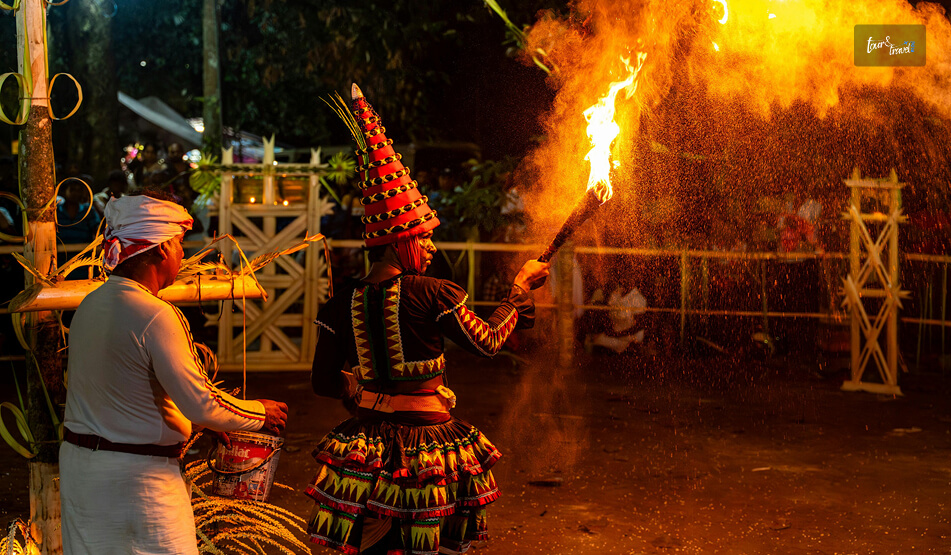
Then the Kavadi bells started ringing, and the drums started rolling. 

In an instant, I understood why people describe this place less as a temple complex and more as a living current that pulls Hindus, Buddhists, Muslims, and Vedda communities.

The sandy courtyard has people who pray, taking different names of the God. 

The temple is fresh off the back of the 2026 Esala Perahera.

This festival, worshipping the Hindu God Skanda (Murugan), drew its usual crowd of pilgrims before wrapping up its final grand procession in late July.

So, Kataragama is once again settling back into its quieter, year-round rhythm.

However, if you ask me, this quieter time is actually ideal for understanding what makes this place so unusual.

Kataragama Temple At A Glance


Detail

Information

Detail

Information

Also known as

KathirkamamRuhunu Maha Kataragama Devalaya

Presiding Deity

Skanda/Murugan for the Hindus
Kataragama Deviyo for the Buddhists

Location

Kataragama, Moneragala District, Uva Province

Distance from Colombo

228 km (via Tissamaharama)

Nearest major town

Tissamaharama (18 Km)

Nearest national park

Yala National Park (adjoins Kataragama)

Sacred river

Menik Ganga (bathing ghats)

Religions represented

Hindu, Buddhist, Muslim, Vedda

Main festival

Esala Perahera/ Kataragama Esala Festival

Festival timing 2027

Around 18th July

Annual festival pilgrims

Over 500,000 (peak Esala season)

Entry fee (temple)

Free (donations accepted)

Complex includes

Maha DevalayaKiri Vehera DagobaValli Amman Kovil Mosque of Al-Khidr

Typical visit duration

Half-day for the complex
Full day with Kiri Vehera and river

Festival dates follow the lunar Esala calendar and shift by a few days each year. So, always confirm current dates through Sri Lanka Tourism or the Kataragama Devalaya administration before booking travel.

My First Impressions Of The Sacred City

My First Impressions Of The Sacred City

Everyone says that Kataragama is multi-religious. However, you can only understand its pluralistic nature after a physical visit. 

I walked from the parking area toward the Devalaya for ten minutes. 

There was a Buddhist family circling the dome of Kiri Vehera in silent reverence. 

There was also a group of Hindu devotees carrying kavadi frames decorated with peacock feathers. 

Again, there was a small cluster of Muslim visitors heading toward the Mosque of Al-Khidr. 

The best thing is that there is no air about something really special happening here by bringing different religions together. 

Everyone worships in a way that feels like this is how it is meant to be. 

The monks, religious teachers, and spiritual leaders of the world only work toward achieving this inclusivity without imposing anything. 

Crossing The Menik Ganga

I stopped at the Menik Ganga (Gem River) before entering the temple grounds. 

I got into the ankle-deep water and washed my hands and face. The cool water was rejuvenating, and it was like entering the temple with clean energy. 

Some vendors were selling flowers on the riverbank. I bought some flowers, betel leaves, and fruits for offering. 

If you also have plans of making an offering to the temple, carry around LKR 100-200 in cash. 

The Walk To The Maha Devalaya 

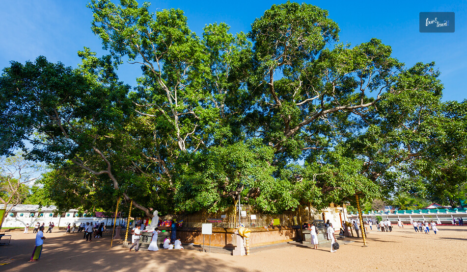
The walk to the Maha Devalaya passes through wide sandy paths. I came across many smaller shrines on the way. 

It was a regular weekday evening, and still there was a crowd of hundreds. 

This means the Devalaya is not a monument that becomes quiet beyond festivals. It is a functioning place of daily worship. 

The Legend Behind The God Of Kataragama

The Legend Behind The God Of Kataragama

There are a lot of stories and beliefs around Skanda, the God of Kataragama. 

Skanda, or Murugan, is the “Dev Senapati” or the warrior leader of the Gods in the Hindu religion. 

He is also called Kartikeya, the son of Lord Shiva and Goddess Parvati. 

However, the Sinhala Buddhists worship him as Kataragama Deviyo.

Kataragama Deviyo is a guardian deity who protects the island. They worship him for spiritual merit and worldly well-being. 

Again, Al-Khidr is a Quranic figure. He is also referred to as the Surah al-Kahf or the rightful servant of God. 

Furthermore, he was someone with great mystic knowledge. 

Nevertheless, the most common story about Skanda is that he arrived here after a falling-out with his consort, Devasena. 

He settled on Wedahitikanda, a hill near Kataragama. 

There he fell in love with Valli, a young woman raised by the indigenous Vedda community.

This love resulted in the union of a celestial figure with an earthly, forest-dwelling people.

Many locals point to it as the symbolic root of Kataragama’s cross-community character even today.

Inside The Sacred Precinct: What You Will Actually See

Inside The Sacred Precinct What You Will Actually See

The complex is larger and more layered than photos suggest. 

It is not a single temple. It is a cluster of many shrines, each with its own rhythm, crowd, and etiquette.

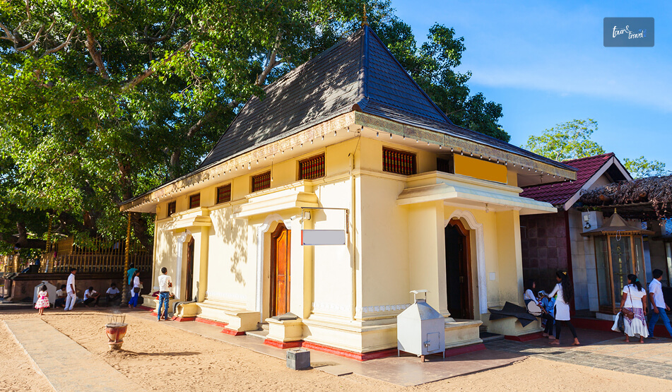
Ruhunu Maha Kataragama Devalaya

This is the central shrine, and Lord Skanda is the presiding deity here.

It has an ornate golden gateway, and it is a favorite photo spot in the temple. 

Irrespective of your religious faith, you can enter the temple courtyard. However, the puja and other rituals in the inner sanctum are performed only by the priests or Kapuralas. 

Evening pujas draw the thickest crowds.

So, if you want space to actually look around rather than shuffle with the flow of people, an early morning visit works better.

Kiri Vehera

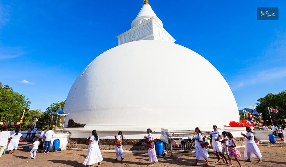
Kiri Vehera is a white dagoba, a short walk away from the main Devalaya. 

It is connected to King Mahasena, one of the oldest Buddhist stupas built around the 6th century BCE.

I circled it barefoot in the late afternoon.

The dome looked beautiful after catching the light. 

It was honestly one of the calmer moments of my visit and a useful contrast after the noise and colour of the Devalaya.

Valli Amman Kovil And The Mosque

The shrine dedicated to Valli, Skanda’s consort, sits a little apart from the main Devalaya.

During the Esala festival, the elephant procession famously travels between the two, symbolically re-enacting their union. 

Nearby, the small mosque of Al-Khidr marks the site’s connection to Islamic tradition.

The Kataragama Esala Festival: Fire, Faith, And The Long Walk From Jaffna

The Kataragama Esala Festival Fire Faith And The Long Walk From Jaffna

Esala Perahera is the main festival of the Kataragama Temple. 

I did not time my own trip around that festival. However, I spoke to local shopkeepers, guesthouse owners, and priests about this event of their year.

What Happens During the Festival

The festival is held annually around the Esala full moon (July–August).

It runs for roughly fourteen nights and draws upward of half a million pilgrims, according to festival guides tracking the event’s scale. 

Nightly perahera processions feature elephants and traditional dancers.

Also, the drummers walk through the town after dark.

The festivities then build toward two of the most intense rituals in Sri Lankan religious life.

One is fire-walking across a bed of white-hot embers, and the other is the closing Water Cutting ceremony on the Menik Ganga at the festival’s end.

The Pada Yatra: A Two-Month Walk To Get There

What struck me most was the journey some pilgrims take to reach it. 

The Pada Yatra is a traditional foot pilgrimage that begins in the Jaffna Peninsula in the north.

Some also start walking from Nagadipa, Vallipuram, Mullaitivu, Trincomalee, and Batticaloa.

This is roughly a two-month walk to reach Kataragama, and they cover a distance of around 400 kilometers in the process. 

They walk along the east coast and through wildlife reserves like Kumana and parts of Yala. 

Also, they sleep outdoors, are fed by villagers along the route, and stop at dozens of shrines on the way.

While talking to a local, he told me that these devotees visit around 70 temples en route. 

I found it very similar to the Kanwar Yatra in the month of Shravan, or July-August, to many Shiva temples in India. 

The tradition nearly disappeared during the civil conflict years but has been steadily reviving since the war ended.

Festival Snapshot


Event

Typical Timing

What to Expect

Best For

Flag Hoisting (Kodi Etruthal)

Mid-July

Ceremonial start of the festival period

Witnessing the opening rites

Nightly Perahera

Throughout the 14-night festival

Elephants, dancers, drummers, processions with torch-bearers

Evening spectacle, photography

Fire-Walking

Final days of the festival

Devotees walk a 20-foot ember pit.

Serious devotees and observers, not participants

Water Cutting

Esala Poya (full moon) night

Closing ritual on the Menik Ganga

Marking the festival’s symbolic end

Getting There

Kataragama is around 228 km southeast of Colombo.

You can travel to Kataragama via Tissamaharama. 

Again, a visit to Kataragama and Yala Safari is the most natural combination you can think of. 

Private car hire from Colombo takes around 4.5–5 hours.

However, if you are traveling on a budget, you can take a bus to Tissamaharama or Wellawaya with a connecting local bus or tuk-tuk into Kataragama town.

The bus ride from Colombo to Tissamaharama takes around 4.5 hours, and the ticket price is around LKR 750. 

Furthermore, from Tissamaharama, a tuk-tuk ride to Kataragama will cost around LKR1800-1900. 

When To Visit The Kataragama Temple? 

If you want to experience the festival atmosphere, you can plan a visit around the Esala Perahera festival in July-August. 

However, there will be a huge crowd and extreme heat. Also, the festivities and noise reach well into the night. 

Again, you need to make bookings well in advance because the accommodations get filled during the festival. 

For a quieter, contemplative visit, choose any other month.

The November to April dry season offers the most comfortable weather for walking around the open, sun-exposed courtyard.

A Simple One-Day Plan Around Kataragama


Time

Activity

Notes

Duration

7:00 AM

Arrive and take a ritual bath at Menik Ganga.

Cooler hours, fewer crowds

30 to 45 Minutes

8:00 AM

Visit Maha Devalaya courtyard

Morning pujas draw smaller crowds than evening.

45 Minutes

9:00 AM

Walk to Kiri Vehera

Circumambulate the dagoba barefoot.

30 to 45 Minutes

10:00 AM

Valli Amman Kovil and nearby mosque

Quieter, less touristy corners

30 Minutes

11:00 AM

Local breakfast in town

Try a simple rice-and-curry stall near the bazaar.

1 Hour

6:00 PM

Return for evening puja at the Devalaya.

The most atmospheric time of day

1 Hour to 1.5 Hours

Continuing The Journey Through Southern Sri Lanka

You can easily combine Kataragama with many other stops in the deep south and east. 

Yala and Bundala National Parks are natural additions for a wildlife experience. However, Yala is getting more crowded every day. 

On the other hand, Tissamaharama and the southern beach towns work well as a base for a multi-day loop. 

Moreover, if you are building out a longer southern Sri Lanka itinerary, you can include the Wilpattu National Park, Hikkaduwa, Mirissa and Unawatuna in your list. 

Thus, a Kataragama stop fits into a wider route.

Share on Social Media

Sibashree is a travel, culture, and leisure writer who has been writing since the age of 12 and professionally since 2014. With more than a decade of travel writing experience and journeys across India and several parts of the world, she brings a deeply personal and thoughtful perspective to her work. A student of English Literature and Mass Communication, Sibashree has always viewed travel as more than movement — for her, it has been a way of understanding people, cultures, and herself. Her passion for spiritual exploration has also led her to many unusual and meaningful destinations over the years. Outside of writing, Sibashree enjoys watching European cinema, reading about global politics, and reflecting on the stories hidden within everyday places.

Leave a Reply

Your email address will not be published. Required fields are marked *

title-img Related

READ MORE Anuradhapura

What Are The Best Places To See In The Sacred City Of Anuradhapura, Sri Lanka? 

BY  Sibashree Apr 21, 2026

Anuradhapura is a part of the Golden Triangle of Sri Lanka, along with the Dambulla Royal Cave Enclave, Polonnaruwa, and Sigiriya Rock Fortress.  Furthermore, the Sacred City of Anuradhapura, a UNESCO World Heritage Site, was built from the "cutting of a Bodhi Tree" or the "Tree of Enlightenment."  Before 993, when it was abandoned due to an invasion, it was the political and religious capital of Ceylon, the previous name for Sri Lanka.  Also, if Jaffna attracted me with its Tamil Culture and Hindu Temples, Anuradhapura was a great calling because it was the first place to adopt Buddhism outside India, the country I belong to.  Moreover, Jetavanaramaya, the early 4th-century BCE Stupa, was once the "third-largest man-made building in the world," with an original height of 122 meters.  However, while the Jetavanaramaya Stupa continues to evoke awe with its grandeur and mystery, the other ruins and remains of Anuradhapura also wait to tell you the history and cultural richness of the region.  So, here is a brief discussion on the places I visited in Anuradhapura.  What Are The Places To Visit In Anuradhapura?  I was staying in a guest house near the Sacred City of Anuradhapura. I rented a bicycle from my guesthouse for LKR 500, and I took the back route as the staff in the guesthouse guided me.  Off the main road, the cycling experience was beautiful, and I loved spotting the roaming peacocks and little children waving at me.  Beyond the charming views and ambiance, I noticed one more thing. In Anuradhapura, the past and the present walk side by side.  There have been no evictions of the locals in the name of preserving or promoting the ancient ruins and remains in a UNESCO World Heritage Site.  Nevertheless, after talking to the local children for a while, I reached the entrance of the Anuradhapura Sacred City. The entry fee was around 9500 LKR or INR 2800.  However, remember that the ticket includes archaeological sites such as Jetavanaramaya, Abhayagiriya, Ruwanwelisaya, and Thuparamaya. So, if you want to explore other sites such as the Isurumuniya Viharaya, you will need to pay separate fees.  Nevertheless, these are the places I visited in Anuradhapura.  "This sacred city was established around a cutting from the 'tree of enlightenment', the Buddha's fig tree, brought there in the 3rd century B.C. by Sanghamitta, the founder of an order of Buddhist nuns.  Anuradhapura, a Ceylonese political and religious capital that flourished for 1,300 years, was abandoned after an invasion in 993.  Hidden away in dense jungle for many years, the splendid site, with its palaces, monasteries, and monuments, is now accessible once again. - UNESCO World Heritage Convention.  1. Abhayagiri Vihara Stupa Complex The Abhayagiri Vihara Gargantuan Stupa is magnificent, and the brick stupa creates a contrast against the bright blue sky and the lush greenery of Anuradhapura.  King Vattagamani Abhaya or Valagamba founded this Stupa in the first century BCE. This prominent center of Mahayana Buddhism remains an active place of worship.  Also known as the Northern Monastery or Uttara Vihara, it changed the course of Buddhism in Sri Lanka by deviating from the monolithic tradition of Theravada Buddhism.  Moreover, the Abhayagiri Vihara Stupa is the first Stupa in Sri Lanka to house the tooth relic of the Buddha.  Also, the Abhayagiri Dagoba or Stupa at the epicenter of the Abhayagiri Vihara Complex is one of the largest stupas in Sri Lanka.  The Structure And Architecture Of The Abhayagiri Vihara Apart from the Stupa or Dagoba, most parts of the Abhayagiri Vihara are in ruins. There were living quarters for the monks and students, libraries, dinner halls, and meeting halls surrounding the Stupa.  Here is a detailed overview of the structures as I saw them. However, the heat will be scorching, and you will find langur monkeys roaming around.  So, try to be there by 6 AM, when the gates open, or after 4 PM. The Sacred City remains open till 8 PM. But it will take you around an entire day if you want to explore the major ruins of the Anuradhapura Sacred City. The Dagoba Or The Stupa  The Stupa or Dagoba in the Abhayagiri Vihara is in a well-preserved condition. The massive bell-shaped structure of the Stupa has a height of around 120 meters, and at its widest, the circumference is close to 350 meters.  The dome, made of brick and lime mortar, has four entrances, and you will find a Devatakotuva, or a cylindrical spire, and a Hataraskotuva, or a square-shaped structure, as the crowns of the Stupa.  Image Houses, Refectoriesand Sub-Shrineses  I saw the remains of various refectories, image houses, living complexes, and sub-shrines around the Stupa.  Among the smaller stupas, the Indikatu Seya and Silasobbhakandaka Cetiya are the most common.  Meeting Halls The remains of the meeting halls or Uposathagharas have been found in the complex.  These Uposathagharas were multi-storied, and Ratnaprasadaya,o r the jewel mansion, was most prominent among them.  Congregation Hall The Sannipatasala, or the congregation hall near the southern entrance of the Stupa, is the largest hall in the complex.  The image of Nagaraja, or the king of snakes, or Virupaksha, the protector of the Western Direction, was found in this congregation hall, which is now in ruins.  You can see this image at the Abhayagiri Museum.  Abhisheka Mandapa Or Anointing Pavilion The Abhisheka Mandapa had a stepped entrance, and people believe it to be the place where the statues of Lord Buddha and other Bodhisattvas were consecrated.  Some even consider this the bathing house or Snanghara.  Stone Slabs  Many stone slabs with inscriptions in Nagari Script have been found at this site.  Again, there are two moon stones in Anuradhapura, and one was found at the Queen's Pavilion and the other at Mahasena's Palace.  These moon stones are significant features of Buddhist stupas or shrines, as these semi-circular stone structures depict the Buddhist Samasara.  The Dining Room The dining room or hall of the Abhayagiri Vihara has a stone-clad trough, and it is ideal for storing or serving rice that could feed 5000 monks.  Furthermore, there was a dining area, hearths, underground channels, grinding stones, and a sundial on the site that Faxian or Fa-Hien described as the dining hall.  The dining hall also has two courtyards.  The Bodhi Tree Shrine The Bodhi Tree Shrine, or the Bodhighara is a subsidiary shrine of the Abhayagiri Stupa. As a token of Buddha's enlightenment, Sanghamitta, a Buddhist nun from India, brought saplings of the Bodhi Tree.  She planted the saplings in Abhayagiri, and many patrons built small aediculae-like shrines around these trees.  These sub-shrines had images of Lord Buddha in a meditative or Samadhi posture and his footprints.  Moreover, excavation of Buddha statues took place in the Bodhighara sites, and one of them is from the 3rd century BCE, and these resemble the sculptures of the great Gupta dynasty in India.  You can visit the Anuradhapura Archaeological Museum if you want to see these Buddha statues. The Ponds  The tanks and reservoirs near the living quarters were the main sources of water for the complex.  However, water in these reservoirs or tanks came from the Kuttam Pokana or Twin Ponds to the far east of the Stupa.  Moreover, these rectangular ponds were built by Aggabodhi I in the 6th or 7th century CE, and they have shallow ridges, and the inner walls are made of polished stone.  However, for me, the most fascinating thing was the stone slab with the motif of a hooded cobra.  Also, this hooded cobra, or Naga, establishes a deep connection with India, as Nagas and water have deep connections in Indian mythology.  As I walked further, I came across the Elephant Pond or Eth Pokuna. It is the largest artificial tank in Sri Lanka, and it is the main water supply for all the tanks and reservoirs in the Vihara Complex.  Here also, I noticed a depiction of a hooded cobra on a stone slab.  At the end of exploring the Abhayagiri Vihara Stupa Complex, I must tell you that you must read a little about the place before a visit.  Otherwise, it will be difficult for you to catch up when the guide shares the details.  2.Jetavanaramayaa Stupa You will also find the Jetavanaramaya Stupa in the Sacred City of Anuradhapura. It was one of the largest man-made structures in the world, and it ranked only after the Great Pyramids of Giza.  The original height of this structure was 122 meters, and after restoration, the height is now 71 meters.  The Stupa, built by King Mahasena in the 3rd Century AD, is a part of a large Jetavana Vihara complex that used to house around 200 monks. Also, like the Abhayagiri Vihara, it has brick architecture.  This once again indicates how ancient Anuradhapura was a hub of brick production. In fact, Ruwanwelisaya, the most sacred Stupa of the country inside the Anuradhapura Sacred City Complex, also had brick architecture.  However, for the recent restoration, they used cement in the outer layer of the Stupa.  Moreover, massive excavation works have taken place in the Sacred City of Anuradhapura, revealing gold panels showing the imagery of the Bodhisattva and partial inscriptions of the Prajñāpāramitā Sutra.  Now, the Prajñāpāramitā Sutra is the foundational text of Mahayana Buddhism. This shows how the Jethawanaramaya Stupa was the hub of different Buddhist thoughts and schools. However, you can see these gold panels now at the Colombo Museum.  Also, I came to know about another fascinating thing from a monk here: that the Stupa used to have a diamond in the crown. It used to turn aside lightning during the monsoon season.  3. The Gleaming White Ruwanwelisaya Stupa  The Ruwanwelisaya Stupa is most famous among the locals and followers of Buddhism.  Now, unlike the Ritigala Forest Monastery, the Ruwanwelisaya Stupa and the other stupas in the complex are live hubs of Buddhist practices.  Also, the Ruwanwelisaya Stupa is especially famous for housing the remains of Lord Buddha.  Originally, the Ruwanwelisaya Stupa was much smaller than the Jethawanaramaya Stupa. However, thanks to continuous maintenance, it now stands at a height of 100 meters.  Now, this was my experience in the ancient ruins of Anuradhapura. If you want to explore more, you can visit the Kaudulla National Park, at a distance of less than 2 hours, and the Hurulu Eco Park, at a distance of 1 hour and 50 minutes.   Location And How To Reach Anuradhapura?  Anuradhapura City is located on the banks of the Malwathu Oya. It is the capital of the central-west region of Sri Lanka and the district of Anuradhapura.  Anuradhapura is a 4-hour journey from Colombo and Kandy.  Once I explored the top attractions in Kandy, I took a minivan, which cost me LKR 1600. Now, you can also take private and public buses.  However, I had luggage and wanted to keep the schedule flexible. So, I chose the minivan.  Things To Remember For A Trip To Anuradhapura The Sun is merciless in Anuradhapura, even if you visit the Sacred City in winter. It becomes unbearable past 11 AM.  So, you have to really start early.  Also, carry water and wear full-sleeve clothes to maintain the dignity of the place and protect your skin from the Sun.  Moreover, as I have mentioned, visiting a place like Anuradhapura demands preparation. So, study well and have basic ideas about these stupas beforehand. 
READ MORE Devon Falls

Devon Falls, Nuwara Eliya: Know The Timings, Entry Fee, Experience, How To Reach And More

BY  Sibashree Aug 29, 2026

Like how I had pulled over for St. Clair's Fall, the same thing happened a few kilometers along the A7.   The driver asked me not to keep my camera aside yet, and suddenly the hillside opened up.   There was a long, narrow ribbon of white water dropping almost straight down into a gorge of tea bushes.  It was Devon Falls, the “Veil of the Valley” in Sri Lanka’s Tea Country. The name comes from how it falls a long way.   So, it more than makes up for the lack of width compared to St. Clair's Waterfall. Here is more about this beautiful waterfall that should be on your Sri Lanka itinerary the next time you visit.   Some Quick Facts About Devon Falls, Nuwara Eliya   Details  Information Height Around 97 Meters Number of Drops  3 Tiers River A Tributary of the Kotmale Oya, Part of the Mahaweli River System Location 6 KM West of Talawakele, Nuwara Eliya District, Central Province Elevation Around 1140 Meters Above Sea Level Entry Fee Free and Viewable from Roadside Platform Nickname The Veil of the Valley Rank 19th Highest Waterfall in Sri Lanka  Where Is Devon Falls And How To Get There? Around 6 kilometers west of Talawakele, Devon Falls is on the A7 highway that connects Colombo to Nuwara Eliya via Hatton.  This waterfall in the Nuwara Eliya District is at an elevation of around 1140 meters. It is in the heart of the Dimbula tea-growing region.   From Nuwara Eliya  The distance between Nuwara Eliya and Devon Waterfall is around 30 kilometers. I took a car from Nuwara Eliya, and it cost me around 3000 LKR.   You can also take a tuk-tuk, which costs around LKR 2000.   The road passes directly above the falls. So, even before you reach the viewpoint, you will get your first glimpse of it through the windscreen.  From Kandy Or Colombo  If you are traveling from Kandy by road, you will reach Devon Falls within 2 to 2.5 hours via Gampola and Nawalapitiya.   Furthermore, from Colombo, it is a 4-hour drive on the Avissawella–Hatton route. Since it is a long journey from Colombo, you can pair it with a night in Hatton or Nuwara Eliya rather than a same-day round trip.  On Foot From The Road  There are two designated car parks along the A7 that double as observation platforms.   Both offer a clear view of the three-tiered drop without any walking required.   If you want a closer look, a short trail leads about a kilometre through the surrounding tea estate toward the base, though the pool itself is not easy to reach.  The Story Behind The Name Of Devon Falls Devon Falls gets its name from Devon, a pioneering English coffee planter.   His plantation once occupied the land nearby.   When coffee cultivation collapsed across Sri Lanka's hill country in the late 19th century due to a leaf-rust blight, tea took its place.  Today, the falls tumble past neat rows of tea bushes rather than coffee, though the name from that earlier era stuck.  What I found most memorable about Devon Falls was not just its height, but how sudden it feels.   St. Clair's spreads its water wide and slow.  Devon narrows it and lets it drop, almost in a single unbroken curtain through the first two tiers before spreading again near the base.   Moreover, standing at the main viewpoint opposite the Mlesna Tea Centre, you get the full length of the fall in one frame, framed by steep, green escarpments on both sides.  What Is The Best Time To Visit Devon Falls?  Season Months What to Expect Wet Season May to September Fuller, more dramatic flow, though mist can obscure the view Dry Season December to March Clearer skies, better for photography, lighter flow Early Morning Any Season, Before 9 AM Less roadside traffic and softer light on the water  Pairing Devon Falls With St. Clair's Because the two falls sit only a few kilometres apart on the same road, almost nobody visits just one.   St. Clair's is the wider, more famous of the pair, while Devon is the taller and, to my eye, the more dramatic.   Seeing both in a single stop along the A7 takes less than half a day, which makes this stretch of road one of the most efficient sightseeing detours in the hill country.  A One-Day Itinerary Around Devon Falls Here's how I'd plan a day trip centred on Devon Falls, starting from Nuwara Eliya or Hatton.  Time Stop Note  8:30 AM Depart Nuwara Eliya or Hatton Aim to reach the falls before the midday tour-bus crowds.  9:30 AM St. Clair's Falls Roadside viewpoint, about 6 km east of Devon.  10:30 AM Devon Falls View from the main platform opposite Mlesna Tea Centre.  11:15 AM Tea estate walk or factory visit Several estates in Dimbula offer short tours.  12:30 PM Lunch in Talawakele Local rice-and-curry spots along the main road.  2:00 PM Onward to Hatton or Nuwara Eliya Or continue toward Adam's Peak if timing allows.   Practical Tips For A Visit To Devon Falls  Both viewpoints are roadside, so no hiking is required if you just want the classic photo.  Traffic along the A7 can be heavy with tour vans in the late morning. So, an early start helps.  Skip swimming here. The pool is difficult to access, and the currents near the base are not considered safe.  Pack a light jacket. At over 1,100 m elevation, mornings can be genuinely chilly even in the dry season.  We only stopped for about fifteen minutes at Devon Falls.  However, it was one of those places that have stayed with me. That long, narrow drop through the tea hills, half-hidden in mist, is hard to shake.

READ MORE world's end sri lanka

World’s End, Sri Lanka: Chasing the View Before the Clouds Roll In

BY  Sibashree Aug 31, 2026

Nobody tells you how early a '5 AM start' actually feels until you are standing in the dark outside your Nuwara Eliya guesthouse, breakfast pack in hand, waiting for a tuk-tuk.   But that is the deal with World's End.  The view is clear from about 9 AM to 10 AM.  After that, clouds roll in off the valley and swallow the whole thing whole.   I had heard this enough times before arriving that I did not question the alarm. And I am glad I did not.  By the time I reached the escarpment, the drop in front of me was still clear enough to see the coast, some 80 kilometres away.  World's End is a sheer escarpment inside Horton Plains National Park, in Sri Lanka's central highlands.   You have to take a circular hiking trail to reach it, and the same route also takes you to Baker's Falls and a smaller companion viewpoint called Mini World's End.  It has become one of the most-hiked routes in the country precisely because the effort-to-reward ratio is so favourable.  It is a manageable walk for a view most people only expect to earn after a serious trek.  World’s End, Sri Lanka: At A Glance  Location Horton Plains National Park, central highlands  Elevation at start About 2,100 metres  Drop at World's End Approximately 870–880 metres  Circular trail distance 9–9.5 km (Red Bridge → Mini World's End → World's End → Baker's Falls → back)  Typical hike duration 2.5–4 Hours  Park hours 6 AM to 6 PM  Best time to visit January to March (Driest Months). You must arrive by 6 AM regardless of season.  Nearest base Nuwara Eliya   Why The Early Start Actually Matters This is not exaggerated marketing. World's End genuinely clouds over by mid-morning most days, often as early as 9 AM.  The park opens at 6 AM, and the guidance from pretty much every guide, driver, and fellow hiker I spoke to was the same.  Get there at opening, start walking immediately, and don't dawdle at Mini World's End if clear skies at the main viewpoint are your priority.   I reached World's End a little under an hour and a half after setting off and had maybe twenty clear minutes before the first wisps of cloud started drifting up from the valley below.  There is no public transport directly to Horton Plains from Nuwara Eliya.  So you are looking at a hired tuk-tuk, car, or a pre-booked tour.  The PickMe app works if you would rather arrange it yourself the night before.   Whatever you choose, the pre-dawn logistics are worth planning a day ahead, since most hotels won't have breakfast ready at 4:30 AM and will instead hand you a packed breakfast to eat on the trail.  The Hike Itself The full loop runs roughly 9 to 9.5 kilometres and is considered moderate rather than difficult.  It is mostly flat with some gentle inclines.   It is well-marked, and it is notably the only national park in Sri Lanka where you are allowed to walk the trail without a mandatory guide.   From the Red Bridge entrance, it is about 2 kilometres to Mini World's End.  Then on to the main viewpoint, before the trail loops back via Baker's Falls, one of the widest waterfalls in the country, and a good spot to slow down once the pressure of beating the clouds is behind you.  Along the way, expect sambar deer grazing close to the trail.  They are genuinely unbothered by hikers here.  I also spotted purple-faced langurs, giant squirrels, and a decent range of highland birdlife.   Leopards are present in the wider Horton Plains area, but sightings are rare enough that I would not build any expectations around it.  Mini World's End Vs. The Main Event  It is easy to treat Mini World's End as a warm-up and rush past it.  However, it is worth a few minutes on its own terms.  A smaller drop, fewer people at that hour, and in some ways a calmer view than the more crowded main viewpoint!  Some hikers reverse the usual direction of the loop specifically to hit World's End last rather than first.  Either way works, but going clockwise from Red Bridge (Mini World's End, then World's End, then Baker's Falls) is the standard and the one most guides default to.  Planning Your Visit World's End earns its reputation honestly.  It is one of the few views in Sri Lanka that lives up to the hype, provided you respect the clock.   The hike itself is forgiving enough for most fitness levels.  Also, the wildlife along the way is a pleasant bonus, and the payoff at the escarpment, on a clear morning, is the kind of view that makes the 5 AM alarm feel like a fair trade.  Entry Fees  Expect to pay in the region of USD 20–25 per foreign adult visitor. Also, you will have to pay a separate vehicle fee if you are driving or being driven in.  The total for a couple with a hired tuk-tuk can run well over what the headline entry fee alone suggests. Fees are collected in USD or LKR at the park entrance.  What To Pack  Pack layers as it is cold enough at 2,100 metres before dawn to want a proper jacket. However, you will likely be down to a T-shirt by mid-hike.   Add sturdy shoes, water, the breakfast pack, and a hat for once the sun burns through.   The terrain does not demand technical gear, but the temperature swing from predawn to midday catches people out.  Best Time Of Year  January to March is generally the driest and most reliable stretch for clear views.  However, the daily mist pattern matters more than the season.  Even in the driest months, arriving after 9 AM risks losing the view entirely. An early start in a wetter month can still pay off.  Where This Fits In A Sri Lanka Itinerary  World's End is a natural pairing with a Nuwara Eliya stay. It is often combined with tea estate visits, Adam's Peak, or the train journey onward to Ella.   Given the early start and 3–4-hour round trip, I would treat it as a dedicated half-day rather than trying to combine it with much else that same morning.  By the time you are back at the entrance, most of the day's clear-view window has already closed anyway.