

Mulkirigala Raja Maha Vihara: Know The Dambulla Of The South Or Little Sigiriya

I was confused when I first heard about Mulkirigala. Some called it the Dambulla of the South because of its multi-level cave complex structure. 

Also, some called it Punchi Sigiriya or Little Sigiriya because of the massive natural rock outcrop and the vertical cliffs resembling the Sigiriya Rock Fortress

Furthermore, to be honest, Mulkirigala was not on the bucket list I had before flying into the deep south of Sri Lanka.

I was more interested in Mirissa’s whale-watching boats and Hiriketiya’s crescent bay.

However, a guesthouse owner in Dikwella insisted that I must visit this rock temple older than Sigiriya. 

It was just forty minutes inland, and I could expect it to be way less crowded than the Dambulla Royal Cave Temple

That combination of history and near-total quiet attracted me. This combination is rare in the tourist circuit of Sri Lanka. 

So, I could not help rearranging one morning around the spot. 

As a reward, I could explore a working monastery carved into and around a 205-meter granite outcrop. 

It had cave shrines and murals from the Kandyan era. 

Also, it had a stone staircase climbing through five distinct terraces to a stupa with views over the Hambantota jungle canopy

In this article, I will discuss what I found at Mulkirigala Raja Vihara, what it costs, and what it takes to get there now. 

There are also some heartfelt inputs about why I feel it deserves a place on more southern-coast itineraries than it currently gets.

Mulkirigala Raja Vihara At A Glance

DetailInformation
Full nameMulkirigala Raja Maha Vihara (also spelled Mulgirigala)
Local nicknamePunchi Seegiriya (“Little Sigiriya”)Dambulla of the South
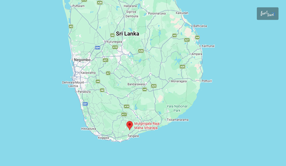
LocationMulkirigala village, Hambantota District, Southern Province
Rock heightAbout 205 metres (673 ft) above the surrounding plain
OriginsTraced to the 3rd century BCRecorded in the chronicle Bodhi Vamsa as “Giriba Vihara.”
StructureFive terracesSeven cave shrinesGranite stairways to climb up
Nearest townsAbout 2 km from Mulkirigala Junction.Reachable from Beliatta, Dikwella, or Tangalle
Protected statusDeclared an archaeological protected monument (Gazette No. 501, 8 April 1988)

A Temple Older Than Sigiriya, And Quieter Too

Mulkirigala predates Sigiriya. 

Long before Kashyapa built his fortress-palace in the 5th century AD, this rock was already a site of Buddhist worship.

It stayed in continuous use through the Anuradhapura, Polonnaruwa, and Kandyan periods. 

The temple I actually walked through, including the murals, the seated and reclining Buddha statues, and the ceiling paintings, mostly date to an 18th-century restoration.

Kandyan king Kirti Sri Rajasinha led this restoration work after the prolonged disrepair, following the reign of Parakramabahu the Great.

The current entrance fee is a modest 500 Sri Lankan rupees for foreign visitors. Additionally, if you are driving or traveling in a car for a round trip, the parking fee will be LKR 100. 

How To Reach Mulkirigala Raja Vihara?

How To Reach Mulkirigala Raja Vihara

Mulkirigala sits inland from the coastal belt between Tangalle and Matara.

So, it is an easy half-day detour from any of the beach towns in that stretch rather than a destination requiring its own overnight stay.

From Tangalle Or Dikwella

This is the most common route to reach Mulkirigala, and I traveled from Dikwella. 

It was a tuk-tuk ride of around 40 minutes, and it was alongthe  Beliatta–Weeraketiya road.

The tuk-tuk turned off at Mulkirigala Junction and continued for around 2 km to the base of the Mulkirigala Raja Vihara. The tuk-tuk charged me around LKR 2700. 

I opted for a half-day hire along with waiting time. 

Here, the exact fare of the tuk-tuk will depend on your negotiation skills and waiting time. 

From Mirissa, Weligama, Or Matara

If you are staying further up the coast, both Tangalle and Dikwella are accessible via the Southern Expressway.

So, Mulkirigala is an easy stop on a day loop that also takes in Dikwella’s Blue Beach or the Hoo-maniya blowhole. 

A hired car or tuk-tuk for the day is the practical option, as there is no direct public bus to the temple itself.

You will get a bus only to Beliatta town, from where a three-wheeler covers the last stretch.

Climbing The Five Terraces

The site is organized into five ascending sections.

The climb is a mix of stone stairways and short paved paths. So, it took me a little over an hour up, with time to linger in each shrine, plus a shorter descent.

TerraceWhat’s There
Patha Maluwa (Lower Terrace)Ground-level entrancePilgrim’s rest areaMonks’ quarters (Sanghavasa)And the small site museum
Bodhi Maluwa (Bodhi Tree Terrace)The Bodhi tree has grown from one of the 32 original saplings of Anuradhapura’s Jaya Sri Maha Bodhi.
Raja Maha Vihara Maluwa (King’s Temple Terrace)The main cluster of cave shrines, with reclining, seated, and standing Buddha statues and 18th-century murals.
Uda Bodhi Maluwa (Upper Bo Tree Terrace)A second Bodhi tree terrace partway up the rock, a natural resting point before the final climb.
Chaitya Maluwa (Stupa Terrace)The summit stupa and open rock platform, with panoramic views over the Hambantota jungle and, on clear days, toward the coast.

The Discovery Of The Vamsatthappakasini Or Mahawamsa Tika In The Cave Temple

In one of the caves on the upper terraces was the place where British civil servant George Turnour discovered palm-leaf manuscripts of  Vamsatthappakasini or Mahawamsa Tika in 1826 to 1827. 

It made the translation of the Mahawamsa Tika possible, making the great historical chronicle of the island more accessible. 

I was standing in that cave. It was dim and cool and felt comforting after the heat of the open stairways. 

However, when I heard about the discovery and its significance, I felt like I was standing inside a footnote of how Sri Lankan history actually got written down.

Also, the Dutch called the same cave “Adam’s Berg,” as they believed it held the tombs of Adam and Eve. 

The Murals Of  Mulkirigala Raja Maha Vihara And What Makes Them Different

Dambulla and Mulkirigala caves felt similar in structure, with reclining and seated Buddhas against painted walls and ceilings.

However, the palette and iconography here were different. 

Several shrines in the cave temple have a mix of Hindu deities and motifs alongside the Buddhist imagery. 

These once again indicate the layered past of the cave temple. 

Also, with these Hindu images, the cave temple shows long, continuous use across different periods of patronage rather than a single unified building campaign.

The murals as they stand today mostly belong to the Kandyan-era restoration. They have flat perspective, bold outlines, and an ochre-and-blue palette typical of royal temple painting from that period.

Moreover, the caves here are smaller than Dambulla. 

I spotted around a dozen other visitors across the entire site during the two hours I spent there. 

Practical Information For Visiting The Mulkirigala Raja Maha Vihara

Things to KnowDetails
Entrance Fee (Foreigners)Approximately LKR 500 Per Person
Opening HoursGenerally Dawn to Dusk
Most Visitors Arrive between 8:00 AM and 4:00 PM.
FootwearTake Your Shoes and Hats off at Every Shrine.
Expect to Walk Parts of the Site Barefoot on Warm Stone.
Dress codeKeep Your Shoulders and Knees Covered.
GuidesInformal Guides often Approach Near the Entrance
Agreeing a Fee Upfront is Optional but Common.
WildlifeResident Macaques are Common on the Stairways.
Time Needed1.5 to 2.5 Hours Round Trip, depending on Pace and Photo Stops.

A Half-Day Itinerary Around Mulkirigala

Because the temple only takes a couple of hours, it pairs naturally with the beach towns nearby. 

TimeStopNotes
8:00  AMDepart Dikwella or Tangalle.Beat the midday heat on the staircases.
8:40 AMArrive at Mulkirigala.Start the climb through the five terraces.
10:30 AMDescend and browse the site museum.Lower terrace, near the entrance.
11:15 AMReturn toward the coast.Stop at Mulkirigala Junction for a roadside lunch.
1:00 PMDikwella’s Blue Beach or Hoo-maniya blowhole.Cool off after the climb.
3:30 PMHiriketiya or Tangalle.Sunset by the water.

Why Is Mulkirigala Raja Maha Vihara Worth The Detour?

Mulkirigala does not have the recognition of Sigiriya, for example, the UNESCO designation. 

Instead, it offers a rock temple with an older foundation and murals worth the climb. 

So, suppose your route already runs along the south coast between Matara and Tangalle. Then, it is a half-day that repays the small effort of getting there.

It is an easy add-on alongside the beach and blowhole stops around Dikwella. 

You can also see this as a cultural counterweight to a coast-heavy itinerary that otherwise skips temples entirely. 

For a fraction of what the bigger cultural-triangle sites charge, you get the staircases, the caves, and the history, just without the crowds.

Share on Social Media

Sibashree is a travel, culture, and leisure writer who has been writing since the age of 12 and professionally since 2014. With more than a decade of travel writing experience and journeys across India and several parts of the world, she brings a deeply personal and thoughtful perspective to her work. A student of English Literature and Mass Communication, Sibashree has always viewed travel as more than movement — for her, it has been a way of understanding people, cultures, and herself. Her passion for spiritual exploration has also led her to many unusual and meaningful destinations over the years. Outside of writing, Sibashree enjoys watching European cinema, reading about global politics, and reflecting on the stories hidden within everyday places.

Leave a Reply

Your email address will not be published. Required fields are marked *

title-img Related

READ MORE bambarakanda

Bambarakanda Falls: A Trek To The Tallest Waterfall In Sri Lanka, Location And Everything You Must Know

BY  Sibashree Aug 27, 2026

Most waterfalls in Sri Lanka announce themselves with a roar from half a kilometer away. However, Bambarakanda Falls was different.   It has a thin water flow, and as it drops far, I could only hear the sound of the waterfall when I was standing directly under it.   However, it is the tallest in the country, and I could not find the top even after craning my neck all the way back.   The Story Behind The Name Of The Bambarakanda Falls The name comes from Bambara. In the Sinhalese language, Bambara means wasps.  The rock face around the falls was once a prominent colony of wasps.   However, before the waterfall became known as Bambarakanda,  it was called Bambarakele Falls and Dultota Falls.   What struck me more than the etymology was how quiet the setting is compared to its size and fame.  This is not a waterfall with restaurants and gift shops crowding the base, just pine forest, a rough access road, and the sound of falling water.  Where Is Bambarakanda Falls? Bambarakanda Falls is close to the small town of Kalupahana in the Badulla District. It is also near the boundary of the Horton Plains National Park.   Kuda Oya, a modest stream, is the source of this waterfall.   However, it transforms into the most dramatic tributary the moment it reaches the cliff edge above Kalupahana and drops in a single, thin, horsetail plunge.   Furthermore, this waterfall is around 200 km away from Colombo. The distance between Bambarakanda Waterfall and Belihuloya is just 18 km.   So, Bambarakanda Falls easily fits into the itinerary if you are in the Central Highlands of Sri Lanka or on the Ella–Haputale–Horton Plains corridor.   How To Reach Bambarakanda Falls? Bambarakanda is easily accessible from Colombo by road and train. Here are the details.   From Colombo By Road  The most common route is Colombo to Ratnapura to Belihuloya to Kalupahana, following the A4 highway toward Beragala.   At Kalupahana Junction, a signposted turn-off leads onto a narrower road that runs for roughly 5 km through Weerakoongama's pine and tea plantations before reaching the parking area.   The final stretch is rough enough in places that not every car will manage it comfortably.  So a tuk-tuk from the junction is a popular last-mile option if you're not driving a higher-clearance vehicle.  By Train And Bus  If you're relying on public transport, the nearest useful rail stop is Ohiya.  From Ohiya, you will still need a taxi or tuk-tuk to cover the remaining distance.   Buses running the Colombo–Badulla A4 route will drop you at Kalupahana Junction, where three-wheelers wait to ferry visitors up the access road for a small fixed fare.  The Trek To The Base  From the parking area, I had to take a flight of steps to reach the base of the waterfall. The flight took around 10-15 minutes.   It was an easy trek as I passed through a pine forest. Also, compared to places such as Sinharaja, the leeches were way fewer in number throughout the route.   However, with the pine needles scattered on the ground, it was a bit slippery. So, you need to wear proper walking or trekking shoes.   As I reached the base of the waterfall, I found a shallow pool, perfect for wading. Also, if you want to remain dry and want to appreciate the scale of the waterfall, you can watch the waterfall from the concrete viewing platform.   Climbing To The Top: The Devil's Staircase  If you want more adventure, you can take the steep trail nicknamed the Devil's Staircase, winding up the mountainside to the crest of the falls.  Remember that this stretch, leading to the top, is a proper hiking route. It is not like strolling anyway!  The elevation here is several hundred meters through pine and mixed forest. So, even if the weather is a little bad, you must not attempt this.   The reward at the top is a small natural infinity pool and a miniature waterfall feeding into the main drop, along with sweeping views down the valley toward the eastern plains.   A short trek from the base also leads to Lanka Ella, a smaller waterfall nearby whose shape is sometimes said to resemble the outline of Sri Lanka itself.  What Is The Best Time To Visit The Bambarakanda Falls? Honestly, the guides on the best time to visit Bambarakanda Falls are mostly confusing.   Some sources say that March to May is the ideal time for a visit to this waterfall. Indeed, going for a trek is safest in this season, as the flow is modest and the trails are less slippery.   However, if you want to see the most dramatic version of the waterfall, May to September is the ideal window.   I am someone who is always in for the later window. Visiting shortly after rain gave me a fuller view of the fall, and it was the most photogenic.   A dry spell, on the other hand, makes the waterfall look thinner.   What Are The Attractions Near Bambarakanda Waterfalls? Some of the best-known sights of the Sri Lankan Central Highlands are very close to Bambarakanda Waterfalls.  Horton Plains National Park and World's End are a scenic drive away. Haputale, with its cooler climate, tea estates, and views toward the southern coast on a clear day.  Haputale further makes a good overnight base. Also, if you are continuing along the A4, Belihuloya offers river-adjacent guesthouses and a much gentler pace than the falls themselves.  Practical Travel Tips  If you are planning to capture the beauty of the waterfall, you should pack wide-angle lenses.   The waterfall is so tall that, considering how close you stand, fitting the entire cascade into one frame from the base is genuinely difficult.  Furthermore, if you are driving yourself to the waterfall, budget extra time for the access road, which is narrow, occasionally rutted, and best driven slowly regardless of your vehicle.  A Few Things I Wish I Had Known  It was a mistake on my part to underestimate the remoteness of the final stretch of the road.  The stretch was just a few kilometers off the main A4 Highway. Still, once I quickly reached the pine forest, there was no phone signal for the majority of the route leading to the base.   Furthermore, you will have to bring cash, as digital payments or cards are not accepted at the entrance or along the trail.  Also, barring the odd roadside stall near the junction, you will not find much food.   Moreover, if you are on the Devil's Staircase climb to the crest, go early in the day. Clouds tend to roll in by early afternoon and can turn a rewarding view into a very damp anticlimax.  Where To Stay Near Bambarakanda Falls  You will not find real accommodation facilities right at the falls.   As convenient options, you can base yourself in Haputale or Belihuloya. You can reach both locations within 30-40 minutes by car from Bambarakanda.   Haputale sits higher up and cooler, with a scattering of small guesthouses and a couple of well-regarded boutique stays that make a good stop if you are also planning to see World's End at Horton Plains the next morning.   Belihuloya, down in the valley, has a handful of riverside guesthouses that suit travelers who'd rather relax by moving water than climb toward it after a long day on the road.   Either option works as a base for a half-day dedicated to Bambarakanda, with enough flexibility to add Horton Plains or a tea-estate walk without much extra driving.
READ MORE demodara railway loop

Demodara Railway Loop: Know The Routes, Train Time, Ticket Price, And More 

BY  Sibashree Apr 22, 2026

Demodara Railway Loop, nestled in the mountains near Ella, Sri Lanka, is one of the most iconic rail routes in the world.  Furthermore, you will get the most amazing views of the Nine Arch Bridge and the train plying through it from the Demodara Railway Loop.  Also, since 2024, this beautiful railway loop has been protected under the New Heritage Management Program.  Moreover, opening on 21st March, 1921, this railway loop has been celebrating more than 100 years of heritage and history.  So, here is a brief account of my beautiful train ride in the Demodara railway loop.  Why Is The Demodara Loop Famous?  Between Ella and Uduwara stations, Demodara is a beautiful railway station in the Uva Province of Sri Lanka.  While extending the railway line to Badulla, the authorities faced a serious challenge due to the steep altitude.  Furthermore, it is famous as the only railway station in the world to be built in a tunnel (Tunnel 42) through which the train passes.  Moreover, this loop, with a length of 441 feet, passes through a 360-degree loop, offering the most amazing views of the surroundings.  Also, it is interesting to know that the design of the Demodara Railway Loop was originally inspired by a Kanyan turban. Then, British and Ceylonese engineers put up the structure. Devapura Jayasena Wimalasurendra was the engineer who conceptualized the idea.  In addition, if you miss the train from Ella to Demodara, you can also enjoy a 9 km hike. The hike continues through tea estates, and then you will meet the iconic Nine Arch Bridge on the way.   Then, you can take a train back from Demodara to Ella. However, I fortunately got to board the trains both times.  A Train Ride In The Demodara Railway Loop  Unlike the Kandy-Ella train ride, a train ride in the Demodara Railway Loop was peaceful.  Also, you could relax even after you saw the train coming out of the tunnel and ascending. It moves very slowly through the loop.  As the train was almost empty and as Sri Lanka demands everything the Travel LowDownUnder philosophy teaches you, I boarded a 3rd class compartment.  I was happy as there was nobody to stop me from peeping through the doors on both sides of the train, and soaking in the beauty of the surrounding lush tea estates.  Also, it was amazing to enjoy a train ride across the iconic Nine Arch Bridge. Moreover, when the train was passing through the Nine Arch Bridge, I could see locals, especially children, standing and waving from the banks of the railway lines.  Overall, it was a comfortable and delightful experience! Insider Tip: When you are traveling from Ella to Demodara, stand near the window or gate on the left side in the direction the train is moving.  From there, you will get amazing views of the Nine Arch Bridge.  Train Time And Ticket Price On The Demodara Railway Loop  If you are traveling from Ella, you will get two trains to the Demodara Railway Loop. So, here are the details of the train timings and ticket prices (Source: Sri Lankan Railways).  Train NameDepartureArrivalTicket Price (LKR)11005 Special 1005 -Ambewela - Badulla 09:30 - 12:1611:25 AM11:40 AM- AC Saloon Car: 2500- Second Class Reserved Seats: 1700- Third Class Reserved Seats: 120011015 Special 1015 -Ambewela - Badulla 15:00 - 17:464:55 PM5:10 PM- AC Saloon Car: 2500- Second Class Reserved Seats: 1700- Third Class Reserved Seats: 1200 Why Is This Iconic Ride In The Demodara Railway Loop Worth It?  Beyond an engineering marvel, the Demodara Railway Loop is an example of historical railway innovation.  Furthermore, when riding in a quiet train carriage, you can enjoy the uninterrupted views of the surrounding mountains and valleys.  Also, this train ride allows you to pass over the Nine Arch Bridge, one of the iconic heritage sites of Sri Lanka.  Moreover, as I was traveling solo, I experienced the joy, spontaneity, and independence backed by the quiet experience. If You Want To Walk From Ella To Demodara  I got to know about the Demodara Railway Loop at the Kadugannawa Railway Museum. It was raining for a few days in Ella, and seriously, I needed to do something to get out of the lull.  So, I decided to take a train ride from Ella to Demodara through the Demodara Railway Loop.  I got the train. However, if you miss the train,” go for a 9 km walk through the countryside and tea-covered hills.  The tea shops, nearby hills, and occasional spotting of peacocks in the bush will keep you entertained.  Moreover, as you descend from Demodara to Ella, you will get sweeping views of paddy fields.

READ MORE Gal Oya National Park

Gal Oya National Park, Sri Lanka: A Place Where I Saw Elephants From Boats

BY  Sibashree Sep 7, 2026

I visited the Gal Oya National Park in 2022, and after a few months of being back in my country, I got a call from my friend in Sri Lanka.  It was December, and he shared the news published on the Daily Mirror Online, which mentioned the threats of illegal mining to the flora and fauna of the national park.  I felt numb, as this was not the Gal Oya National Park I visited. Even if Sri Lanka has icons such as the Yala National Park, for me Gal Oya offered the most remarkable encounters with elephants.  For the first time, I did a safari from a boat, drifting quietly across open water while a herd of elephants waded between islands ahead of us. There was no engine noise to spook them, no queue of vehicles, just the reservoir, the herd, and the sound of water. It felt more like a secret that Sri Lanka preserves so dearly, not a national park.  Gal Oya National Park At A Glance DetailInformationLocationAmpara District, Eastern Province, Sri LankaEstablished1954AreaApproximately 25,900 HectaresCentrepieceSenanayake Samudraya, the Largest Reservoir in Sri LankaKnown forBoat Safaris and Elephants Swimming between IslandsWildlife32 Recorded Mammal Species, including Elephants, Leopards, and Sloth Bears150+ Bird SpeciesBest time to visitDry Season, Roughly May to SeptemberDistance from ColomboAround 300 KM,  Roughly 6 Hours by Road A Reservoir-Built Park With A History Tied To Irrigation The history of the Gal Oya National Park goes back to 1954. It was built to protect the Senanayake Samudraya. This newly constructed reservoir, the largest in Sri Lanka, was part of a major post-independence irrigation scheme in the dry zone of Sri Lanka.  The scale of the reservoir made my boat ride in the park all the more fascinating. It is just open water with forests around.  So, the jeeps on the dusty tracks are replaced by the boats on the serene water.  The landscape around the reservoir was more varied than I expected from a dry-zone park. Forested Hills! Savannah Grassland! Also, there were rocky outcrops that locals call turtleback formations.  Moreover, low grasslands all sit within the park's boundaries, alongside historical sites like the Digha Vapi Dagoba and the Henebedde cave. Wildlife And The Swimming Elephants The most fascinating experience in Gal Oya was watching wild elephants swimming between the reservoir’s islands.  They were moving in search of fresh grazing as water levels dropped in the dry season.  Beyond elephants, the park has around 32 mammal species, including: Leopards Sloth Bears Grey Langurs Endemic Toque Macaque. Also, the park, though not as fascinating as Bundala, has more than 150 species of birds. I could spot the following ones. Painted Storks Ospreys Endemics like the red-faced Malkoha and Sri Lanka spurfowl. I could also spot crocodiles and water monitors along the reservoir's edges. How To Reach Gal Oya National Park? You can take a drive from Colombo to reach Gal Oya National Park via Ampara. The distance is around 300 km, and the journey takes around 6 hours by road.  However, staying in Ampara Town as the base or finding a lodge close to the park’s boat safari jetty is a more reasonable move.  Also, Gal Oya National Park is a natural inland detour from the east-coast surf town, Arugam Bay, roughly 2 to 2.5 hours away. Again, if you are traveling from Kandy, it is 4-5 hours by road via Mahiyangana. So, Gal Oya is a workable stop on a route heading toward the east coast. Gal Oya Entrance And Boat Safari Costs (2026) On top of the park entrance fee, the boat safari itself is typically arranged and priced separately, usually through your lodge or a licensed operator. Remember that access to the reservoir's boats isn't managed the same way jeep permits are at other parks. Also, the boat safari costs around LKR 6000 to LKR 8000.  CategoryApproximate Cost (2026)Foreign Adult (12+)USD 12Foreign Child (6–12 Years)USD 6Foreign Children under 6 Years FreeSAARC NationalsUSD 10 for AdultsUSD 5 for Children between 6 and 12 YearsFree for Children below 6 YearsLocals Adults: LKR 60Children from 6 to 12 Years: LKR 30Children below 6 Years: FreeStudents: LKR 20Boat SafariLKR 6000-8000 A One-Day Gal Oya Itinerary A day at Gal Oya has a different rhythm from most Sri Lankan national parks because here the safari is on a boat and not a jeep.  Here is a structure that works well if you're based near Ampara or the park's eastern lodges. TimeActivity5:30 - 6:30 AMEarly transfer to the boat jetty on Senanayake Samudraya6:30 - 9:30 AMMorning boat safari.It is the best window for elephant sightings near the shoreline. 9:30 - 10:30 AMReturn to lodge for breakfast.10:30 AM - 12:30 PMOptional short trek or visit to the Henebedde cave/Digha Vapi Dagoba area.12:30 - 2:30 PMLunch and rest during the hottest part of the day.4:00 - 6:30 PMEvening boat safari for a second wildlife window and sunset over the reservoir. What Are The Practical Tips For Visiting The Gal Oya National Park?  Boats and slots are more limited than jeep availability at bigger parks. Bring a hat, sunscreen, and a light waterproof layer. Pack a zoom lens or good binoculars as elephant sightings are often across open water rather than at close range on a jeep track. Stay two nights if you can, so you get both a morning and an evening boat safari rather than just one. Combine with Arugam Bay or Ampara for a fuller east-coast itinerary. What Is The Best Time To Visit Gal Oya National Park? May to September, or the dry season, is the best time to visit Gal Oya National Park.  In the dry season, the water level of the reservoir drops. So, all the animals, especially the elephants, concentrate near the remaining islands and water.  Thus, the sight of swimming elephants is more common in this national park than anywhere else in Sri Lanka.  This season is also ideal for birdwatching in Sri Lanka, as migratory and resident species settle around the shrinking waterline.