


How About Exploring The Hiking Trails in Channel Islands National Park?

Aug 20, 2024

Last Updated on: Sep 1, 2025

Travel Blog

It’s hard to imagine that a watery wonder and a versatile geological place exist so close to the Californian Mainland. Yes, we are talking about the Channel Islands National Park. 

Rich in diverse flora, fauna, and wildlife, this national park, consisting of five islands, is a hiker’s favorite. The hiking trails on each island are different. For example, the trails in Anacapa are flatter, and they get steeper as you visit Santa Rosa or Santa Cruz. 

Also, as a critical marine sanctuary, this national park offers an amazing experience for people interested in aquatic pursuits. Boating and scuba diving here are activities that an adventurous soul will surely look upto. 

Are you ready to pack your bags and hit the trails? Let us join you.

Channel Islands Hikes That You Just Cannot Miss 

Hiking trails in the five islands of this national park vary in their difficulty parameters. The trails in Anacapa, Santa Rosa, San Miguel, Santa Cruz, and Santa Barbara are easy (Cavern Point Loop), moderate (Potato Harbor), and hard (Montañon Ridge Loop). 

As a hiker, you have to be sure of your physical and mental endurance before you start exploring specific trails. Further, you will encounter many challenges as you explore the hiking trails. 

Common perils here include poisonous oaks, scorpions, ticks, wildfire risks, reptiles, and Hantavirus spread by deer mice. To deal with these hazards, you must make the most of the buddy system and, most importantly, be respectful to the wildlife. 

However, the pain you have to undergo throughout the journey is worth the dramatic experience the trails offer. It’s time to know about them. 

Anacapa Island Hiking 

Anacapa Island got its current name from its original Chumash Native American Indian name, Anypakh. This island is made of East, Middle, and West Anacapa islets, and surprisingly, none of these are connected to each other. 

Before I introduce you to some of the most amazing trekking trails in Anacapa, let me share some highlights about the island.

Anacapa Island: Things To Know
Anacapa is known for its diverse vegetation, wildlife, culture, and history.
Coreopsis and sunflowers come to life after the winter rain, and you can see them from the California Mainland.
Anacapa is the largest breeding colony of western gulls in the world.
It is also the largest breeding colony of the California brown pelicans, which are endangered species.
Chumash Indian people used to camp here thousands of years ago.

Inspiration Point Hike (Easy)

Just a 1.5-mile hiking trail, Inspiration Point offers the most amazing view of the island. Enjoy the sheer contrast created by vibrant wildflowers and the tranquil blue water. 

Pinniped Point Hike (Easy)

Pinniped Point hike, which is a 4-mile distance, is known for its sea lion rookery and lighthouse. 

Cathedral Cove Hike (Easy)

The 6-mile hiking trail is the best place to see the most amazing rock formations. Here, you will also find beautiful kelp forests, sea lions, sea caves, and birds. 

San Miguel Hiking 

Hiking in San Miguel is a little tricky as you cannot take the off-trail roads. Further, hiking is only limited to certain spots, as its unique geological features, wildlife, and plants need preservation. 

Caliche Forest Hike (Hard) 

Despite its difficulty level, Caliche Forest is the most exciting trail to hike in San Miguel. This landscape of five miles has naturally calcified prehistoric vegetation. So, the entire area has the most surreal “fossilized” appearance.

A visit to this trail is like a time travel, and the feeling is, at times, eerie. 

Cuyler Harbor Beach Hike (Easy)

Enjoy the pristine beauty of the 2 miles of white sand stretch and observe the adorable seals. Take a walk along the beach to find the sand running into the rocks. 

Cabrillo Monument Hike (Hard) 

The distance of this trail is 2 miles. However, the steep climb makes the hiking experience very strenuous. You will visit the monument of Juan Rodriguez Cabrillo, the first European to explore this island.  

Santa Cruz Island Hiking 

Santa Cruz, or the La Isla de Santa Cruz, is the land of the Sacred Cross. Known as Mini California, this island has endless bounties to offer. From the Transverse Mountain ranges to the deep valleys, canyons, and beaches! You will meet the most diverse geological picture here.

Here, I will talk about some of its most prominent hiking trails. However, before that, let’s share some interesting facts about the island.

Things To Know About Santa Cruz Island
Size: 96 Square Miles (The Largest Of The 5 Channel Islands)
Plant Species: 600
Plant Communities: 10
Landbird Species: 140
Land Mammal Species: 11
Cultural History: More than “10,000 years of American Indian habitation, 150 years of European exploration”

Cavern Point Loop Hike (Easy)

Cavern Point Loop is a popular destination for hiking, kayaking, and seasonal whale watching. As you trek through the 2 miles route, you will get to see the most magnificent coastal vistas. 

Potato Harbor Hike (Moderate) 

The harbor gets its name from its unique oval or potato shape. The cliffs here are steep and dangerous. The bright white sedimentary rocks (diatomaceous earth) here are formed by diatoms or single-cell sea plants made of silicon dioxide. 

Diatomaceous earth has wide applications in filtering water. 

The Giant Kelp Forest is another attraction in Potato Harbor. Kelp is a nutrient-rich and fast-growing algae that helps build a rich marine ecosystem. The California sea lions here will make your visit to the island most delightful with their playful nature. 

Montañon Ridge Loop (Hard)

Montañon Ridge, with Montañon Peak and High Mount, is the highest ridge on the eastern side of the island. This trekking trail is only for experienced hikers. 

The total distance of the hiking trail is 10 miles. 

Santa Barbara Hiking 

Santa Barbara is an island for endless outdoor pursuits like hiking, camping, fishing, and watching wildlife. 

Further, Santa Barbara is the island to be if you want to explore the local vegetation. If you visit the island in spring and winter, you will meet the most colorful wildflowers here. Also, delightful flowers like poppies and verbenas are in full bloom in the summer.

Do you want to hike on this island? Here are some trails for you. 

Lizard’s Mouth Hiking Trail (Moderate)

You have to take just a quarter-mile walk off West Camino to find this hiking spot. It’s also a favorite Santa Barbara destination for picnics. 

The place gets its name from the rock formation resembling a lizard’s open mouth. This place is picturesque and perfect for photoshoots. 

La Cumbre Peak (Diificult) 

With the highest elevation of 1215 m, the La Cumbre Peak (the highest in Santa Barbar) hike is full of challenges. However, this trekking trail is full of highlights like the Cathedral and Arlington Peaks, the coastline to the sea, etc. 

San Roque Creek (Easy)

The San Roque Creek trail is located in the 25-acre recreation area in the park. The area is called Stevens Park. With just an elevation gain of just 93 m, it is an easy trail to explore, and you can have a great time walking with your dogs here. 

Santa Rosa Hiking 

The hiking trails in Santa Rosa are a combination of flat and steep terrains. The trails to the Water Canyon Beach are flatter. At the same time, roads to the Black Mountain are strenuous. 

Water Canyon Campground Hike (Easy)

This 3-mile hiking trail is one of the easiest routes in Santa Rosa or all over the Channel Islands. Enjoy a gala picnic with your group here. 

Water Canyon Hike (Moderate To Strenuous)

The perennial canyon and the local vegetation make the water canyon hike the most amazing experience. If you want, you can also follow the stream bed and get wet. 

Black Mountain Hike (Hard)

With a distance of 8 miles, this trail offers the most amazing views of the mainland and San Miguel, Santa Cruz, and Santa Rosa islands. 

Did You Know?

By 1928, many fossils of pygmy mammoths were found in the Channel Islands. Further, almost a complete skeleton of an adult pygmy mammoth was excavated on Santa Rosa Island in 1994.

These mammoths were very similar to the Californian mainland mammoths. However, they evolved and got smaller in size to accommodate on the Channel Island. Worldwide, these mammoths are known as Channel Islands Pygmy Mammoths. 

Final Words 

Channel Islands National Park had 328,746 visitors in 2023 (Source). Despite being close to the California mainland, these islands offer tranquility, and with many places to visit and activities to do on the five islands, you will surely be spoilt by the choices at this national park. 

On all the islands, you can trek, fish, camp, and take part in many water sports. However, two of the most coveted activities in these parks are hiking and exploring marine life. The variety you find here in whales and other marine mammals can be a close match to the vibrant marine ecosystem of Wrangell-St. Elias National Park. 

In this guide, I have highlighted trekking through the trails in this national park. Do you want to know more about its wildlife and marine ecosystem? Share your thoughts in the comment below. 

Channel Islands National Park FAQs 

Which Island Is The Best To Hike In Channel Islands National Park?

Anacapa and Santa Cruz islands are great for hiking in the Channel Islands. However, if I am to share my opinion, Anacapa will be my silent favorite. 

The trekking trails here are way easier in Anacaopa than in Santa Cruz. So, irrespective of your expertise level, you will be able to hike the entire island in a day. 

Also, as the trekking journey here is less arduous, you will be able to enjoy the surrounding scenic beauty even more. You will meet the most adorable sea birds, sea lions, and seals. Also, if you are lucky enough to be in these mountains during spring or late winter, you will find the mountains replete with colorful wildflowers.

Inspiration Point, Cathedral Cove, and Pinniped Point are some of the highlights of hiking expeditions in the Anacapa Islands. 

What Is Special About Channel Islands National Park? 

Channel Islands National Park is special because it is a paradise for trekkers, nautical surfers, and wildlife explorers. 

Its San Miguel, Santa Rosa, Anacapa, Santa Barbara, and the largest, Santa Cruz islands have many hiking trails with Transverse Ranges. 

Further, half of the national park is under the ocean, and you will find six nautical miles of water around it. So, it is a critical marine sanctuary and a great place for scuba diving, boating, and other aquatic pursuits. 

In addition, its wildlife is mesmerizing, with the presence of animals like island foxes, spotted skunks, salamanders, whales, California sea lions, sea otters, dolphins, giant black seabass, and more. 

Which Island Is The Largest In Channel Islands National Park?

The largest island in the Channel Islands National Park is Santa Cruz, which is also known as the epitome of California. Its size is 96 square miles. 

Its geology is versatile, with Transverse Ranges, fault systems, springs, streams, and canyons. You will also come across sea caves, beaches, and coastline cliffs. Among the sea caves, the Painted Cave is the most prominent one with lichens, algae, and colorful rocks.

Also read

Share on Social Media

Sibashree is a travel, culture, and leisure writer who has been writing since the age of 12 and professionally since 2014. With more than a decade of travel writing experience and journeys across India and several parts of the world, she brings a deeply personal and thoughtful perspective to her work. A student of English Literature and Mass Communication, Sibashree has always viewed travel as more than movement — for her, it has been a way of understanding people, cultures, and herself. Her passion for spiritual exploration has also led her to many unusual and meaningful destinations over the years. Outside of writing, Sibashree enjoys watching European cinema, reading about global politics, and reflecting on the stories hidden within everyday places.

Leave a Reply

Your email address will not be published. Required fields are marked *

title-img Related

READ MORE When can navigation rules be overlooked

When Can Navigation Rules Be Overlooked?

BY  Mashum Jan 5, 2023

If the question arises of when can navigation rules be overlooked, then the answer is that they should never be overlooked. However, there are moments when you only have the option to ignore these rules. Certain situations and groups can ignore and overlook these rules whenever they want. To know them, too, scroll down below. What Do You Mean By Navigation Rules? For every water vessel traveling through water bodies, specific rules are enforced to see their safe travel. These rules are like the traffic rules, but except for roads, they are for the waterways and waterbodies. These navigation rules ensure the safety of the vessel and the passengers onboard from dangerous rocks, shallow waters, and reefs. When Can Navigation Rules Be Overlooked? The navigation rules are set in place to ensure safe and secure travel on water, but there are moments when these rules need to be followed sometimes. So the situations that can force the sailors to ignore the navigation rules are as follows. Crossing Dangerous Waters When you are crossing turbulent and dangerous waters, with the people on board being unsafe, the navigation rules can be overlooked; their priority is to protect the passengers. When it comes to sailors, during storms and dangerous turbulent waters, they are not bound to follow the navigation rules. They can easily overlook them. To Avoid Immediate Danger Who may depart from the navigation rules? The operators may need to depart from the navigation rules while trying to mitigate imminent dangers. While traveling over waters, danger can happen anywhere, and at any point, so paying proper attention to the navigators is essential. They are trained for any sudden changes in water and air direction. So if travelers and navigators predict something dangerous, they can ignore all the navigation rules. This is how they can keep the onboard passengers safe. When A Vessel Has Little Maneuverability If the captain and crew feel like the vessel is going through a little maneuverability, then they are allowed to overlook all the navigation rules for boats. It is more important to keep the passengers safe than to travel in a hazardous environment. When The Sailor Is Inexperienced It is important that navigators and sailors should know how to navigate their way around the water. That way, they don't end up endangering the lives of others on the vessel. To save time, these inexperienced sailors sometimes disregard all the maritime navigation rules that are in place. When can navigation rules be overlooked? â€“ if you are a navigator or sailor, look back to your novice years. Sailing In Poor Visibility When a sailor is sailing in a situation with poor visibility, then the rules of navigation are ignored. If the radar is not working properly, then the navigation rules can be ignored. When climatic situations make it difficult to see, and visibility becomes a big issue, navigation rules are entirely ignored. That is when experience and intuition come into action. What Are The Basic Rules Of Navigation? The "rules of the road at sea," or navigation regulations, apply to all boats. These regulations clearly indicate when to pass, approach, yield, and overtake other boats. The International Rules for Preventing Collisions at Sea (ColRegs) and the fundamental rules of the water should be familiarized with by all boaters, regardless of the size of their vessel. For other masters to see your intentions, you should always move in a clear and deliberate manner. Never assume that the captain of a different boat will follow the rules; always be ready to prevent a collision. To prevent collisions with other boats, the Colregs provide clear signals for passing, approaching, giving way, and overtaking. These are the rules for boat traffic. Rules: Here are some of the basic rules of navigation that you need to be aware of when at sea: When navigating a river or channel, a boat must always operate on the starboard (right) side. You have the right of way when a boat approaches from your starboard (right) side. You have right of way if you approach another boat from the starboard side. However, you must act to avoid collision if the other boat does not yield. Each boat changes course to port (left) and changes course to port (right). Always assume that this is the case. You have the option of overtaking a boat from either side of the one you want to pass. But you have to stay far away from the boat you're passing. This is true for sailboats as well as powerboats. The sailing boat with the wind on the port side must give way when there are two boats with wind on opposite sides. The boat to windward must yield to the boat to leeward when both boats are facing the same direction. Sail usually triumphs over power. However, this isn't always the case. Due to their size, larger vessels, like ferries and container ships, are difficult to maneuver. By giving larger vessels a wide berth, masters of other boats, including sailboats, should always use common sense and good seamanship. What Are The Consequences Of Overlooking Navigation Rules? For those asking, "when can navigation rules are overlooked," it is essential for you to know that there are severe consequences for not following the rules. And some of the effects that may befall you if you overlook the navigation rules are listed below. They are endangering the environment. The ship and its onboard passengers can get lost at sea. With overlooking the navigation rules, a shipwreck is a strong possibility. A hazardous environment on the ship can create a dangerous place for the people onboard. This can lead to health issues and even death. The vessel and passengers can face legal trouble for not following the navigation rules. Read More: What Are The Different Types Of Cruises (And How To Choose The Right One For You)? Who May Depart From The Navigation Rules? The navigation rules are set up for everyone's safety and security, so not following them can be risky. However, some people ignore these rules to stay safe and do their work. Please scroll down to see who these people are, who can overlook the navigation rules whenever they want. Pirates And Illegal Fishermen For pirates, the rules of navigation don't apply. They are beyond any rules, which is why they are pirates. They do this so that law enforcement can't catch them, and they can run away free. That is the same for fishermen who are fishing illegally. Those In Imminent Danger The recent enforcement requires maritime law that the answer to the question of when navigation rules are overlooked is during imminent danger. Escaping a dangerous situation is much more important than abiding by the law. Read More: What Is Most Likely To Cause Someone To Fall Overboard? Research Vessels Marine life science research vessels can easily deviate from the navigation rules. The study is based on marine life and the ocean, so they need help to go by the navigation rules. Those Experiencing A Mental Health Crisis If someone goes through a mental health problem on a vessel, they can let go of the rules. Instead, they don't tend to follow them. In addition, if someone is emotionally distraught or under the influence of alcohol or drugs, they might not follow the rules. Wrapping Up! Now that you know the situations and people who tend to ignore the navigation rules, your question of when navigation rules can be overlooked is answered. In these situations, people don't regard such laws when they travel on international waters. So if you want to know more about this topic, we have more articles on our website, so browse through them, but first give us a like and comment below. Read Also: The Ultimate Hotel Tipping Guide Top 10 Best Beaches In Florida For Families Speed Boat Miami Tour – Sightseeing And Entertainment

READ MORE Jetavanaramaya

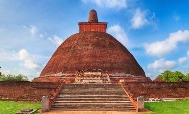
Jetavanaramaya: Standing Before The Tallest Brick Stupa In Anuradhapura

BY  Sibashree Sep 18, 2026

Jetavanaramaya is in the Sacred City of Anuradhapura, one of Sri Lanka's UNESCO World Heritage Sites.  It is easily the most physically overwhelming structure I have seen anywhere on the island.   Can you believe that this stupa was built using 93.3 million baked mud bricks in 301 CE?  Even today, though the stupa is around half the height of the original stupa, it still impresses, with a towering height of 71 meters.   Furthermore, archaeologists think that a three-foot brick wall could be constructed between London and Edinburgh or New York City and Pittsburgh with these mud bricks.   However, Jetavanaramaya is not just about the imposing height.   It has a rich history and spiritual significance. Also, recent news has put it back in the global spotlight.  I will discuss all these aspects in this article, along with everything you need to plan the trip yourself.  Jetavanaramaya At A Glance  Detail Information Location Jetavana Monastery, Sacred City of Anuradhapura, North Central Province, Sri Lanka Built by King Mahasena (r. 273–301 CE) started the construction  It was completed by his son, Sirimeghavanna/ Maghavanna I Original height Approximately 122 metres  It is the tallest brick structure ever built. Current height Approximately 71 metres, after 12th-century restoration under King Parakramabahu I Bricks used An estimated 93.3 million baked bricks Global ranking (at completion) Third-largest man-made structure on Earth, after the two Great Pyramids of Giza Base area Roughly 233,000 m²  Relic enshrined Believed to be a fragment of a sash or belt worn by the Buddha. UNESCO status Part of the Sacred City of Anuradhapura, inscribed as a World Heritage Site in 1982 Nearest town Anuradhapura city centre, about 4–5 km away  A Recent Spotlight: Jetavanaramaya's 2026 Global Moment Jetavanaramaya does not need an introduction due to its architectural magnanimity or significance in Buddhism.   However, it has become a talking point once again with CNN Travel publishing a detailed feature recently.   In the February 2026 post, CNN Travel has described it as “massive megastructure built for eternity.”   Also, the same post places it alongside the Great Pyramids in terms of ancient engineering ambition.  The piece, reported from Anuradhapura itself, spent time with Godamune Pannaseeha, a senior archaeology officer who has spent years studying the site.  Also, it framed the stupa within the living pilgrimage culture that still surrounds it.  As I have seen it, there were pilgrims in white, monks chanting at dawn, rituals that have continued largely uninterrupted for more than 2,000 years.  The coverage was picked up widely across the US and international outlets in the weeks that followed.  Moreover, Sri Lankan media noted it as a rare moment of global attention for a site that, despite its scale, remains far less visited than Sigiriya Rock Fortress or the Temple of the Tooth.   If you are planning a Cultural Triangle trip in 2026, this is genuinely a good year to see it before the crowds catch up to the coverage.  The History Behind The Tallest Brick Stupa In The World Jetavanaramaya is a physical record of a religious dispute.   Understanding why it exists makes the visit land differently, even if we forget about the height or scale for a while.  King Mahasena And The Sect Rivalry That Built It  King Mahasena began construction of this stupa between 273 and 301 CE.  It was during a period of real tension between two Buddhist sects, the Mahavihara and the more liberal Abhayagiri fraternity.  Mahasena was a patron of the Abhayagiri fraternity.   The stupa became the centrepiece of the Jetavana Vihara, a monastic complex built for the breakaway Sagalika sect.  It was designed, according to archaeologists, to accommodate more than 3,000 monks.   Every structure in the complex was oriented toward the stupa.  It was a daily, physical reminder of where devotion was meant to point.  The Relic Enshrined Inside  Jetavanaramaya is a solid stupa, not a hollow one.  So, you cannot go inside.   What's believed to be enshrined at its core is a fragment of a sash or belt worn by the Buddha.  Thus, it is a cenotaph of deep religious significance rather than a burial monument in the ordinary sense.   Some accounts also connect the site to the cremation of Mahinda Thera, the monk credited with bringing Buddhism to Sri Lanka.  This version about the stupa comes from the excavated ash and charcoal layers found nearby.  Restoration Through The Centuries  Like most of Anuradhapura, Jetavanaramaya fell into decline after the capital shifted away from the city.  It was buried gradually by jungle growth and centuries of neglect.   King Parakramabahu I restored it in the 12th century, bringing it to roughly its current height.   Large-scale conservation further resumed in the 20th century, and it remains an active restoration site today.  Even in its diminished state, it is still the largest man-made brick structure by volume.  What It Is Really Like To Stand Before Jetavanaramaya Honestly, photos do not give a fair idea about the scale of the stupa.  Standing at its base, this is what I actually felt.   The Scale You Don't Expect  A height of 71 metres and made of 93 million bricks!  Reading about these numbers is different from actually walking the perimeter.   Each side of the base runs close to 576 feet, and the entrance staircases alone are around 28 feet wide.   It was a long walk circling the structure once.   However, the brick structure was more fascinating, with a distinct texture and color.   Furthermore, the uneven weathering of this deep terracotta structure is an art time has created.   No photograph truly captures that.   Golden Hour And The Rituals Around It  Afternoon is the best time to visit the stupa.   The heat is less, and the stupa looks warmer with a red-orange hue thanks to the light.   Also, this is the time when pilgrims in large numbers circumambulate the stupa clockwise.  They walk barefoot with flowers or lit oil lamps in their hands, and suddenly you see evening has set in.   Exploring The Jetavana Monastery Complex The stupa is the epicenter of the monastery complex.   However, if you want to know more about the history and soak in the spiritual ambiance, explore the other structures mindfully.   The Jetavanaramaya Museum  This on-site museum is small, but it displays artefacts recovered during excavation.  I saw beads, coins, ivory carvings, pottery, and inscribed stone fragments, along with information panels on the sect rivalry that produced the stupa.   It takes around 30 minutes to explore the museum. However, it is a useful stop, considering the information it provides.   Nearby Ruins Worth Your Time  There are remains of monastic buildings, ponds and boundary walls around the stupa.   The refectory ruins and stone urinals with their surprisingly intricate carved drainage systems especially demand a mention.  These structures hint at an organised monastic life.  Entrance Fees And Tickets Jetavanaramaya is covered by the single Anuradhapura Sacred City round ticket.  So, you do not need to buy a separate ticket for it.   Visitor category Approximate price (2026) Notes Foreign adult (non-SAARC) US$25–30 Covers:  Jetavanaramaya Ruwanwelisaya Abhayagiri Thuparamaya, and other sacred-city sites SAARC nationals US$12–15 Passport required at the counter Children (6–12) Around half the adult rate Under 6 generally free Local (Sri Lankan) visitors Free ID required and a small fee applies only for the site museums Combined Cultural Triangle ticket US$50–60 Covers:  Anuradhapura Polonnaruwa Sigiriya  Dambulla Royal Cave Temple   Note that the Sacred City round ticket does not include Isurumuniya, Sri Maha Bodhi, or Mihintale.  So, you will need smaller entry tickets.   You can buy tickets at the main office near the Archaeological Museum, or pre-book online to skip the queue.  Opening Hours And Best Time To Visit Jetavanaramaya The archaeological sites are generally open daily from around 7:00 AM to 6:00 PM.   Avoid the midday window (roughly 12:00–3:00 PM), when the heat over the open brick platform gets genuinely uncomfortable.   Early morning and the last two hours before closing are both good choices.  The latter also lines up with the evening rituals.   Moreover, December to March is the most pleasant season weather-wise, with lower humidity and less rain.  Getting There  Anuradhapura is roughly 200 km north of Colombo.  The journey takes around 4.5 hours by car.   Also, it is about 65 km from Dambulla.   Moreover, in a Cultural Triangle itinerary, it pairs naturally with Sigiriya, Dambulla, and Mihintale.   Again, since the Sacred City is vast, you can rent a bicycle for the day to move around.   The bicycle rental costs around LKR 1500 for a day.   Furthermore, you can hire tuk-tuks and cars with a driver-guide.  A Suggested Half-Day Itinerary For Jetavanaramaya  Time Stop What to expect 7:00 AM Sri Maha Bodhi Dawn pilgrimage atmosphere at the sacred fig tree. 8:00 AM Ruwanwelisaya The gleaming white stupa and its elephant wall. 9:15 AM Jetavanaramaya Spend at least an hour, and more with the museum. 10:45 AM Jetavanaramaya Museum Excavated artefacts and site context. 11:30 AM Abhayagiri Dagoba The third great stupa, with a quieter, more forested setting. 1:00 PM Lunch in Anuradhapura town Break before the afternoon heat.  Tips From My Visit To Jetavanaramaya A local guide (arranged through your hotel or the ticket office) adds real value here. You cannot know much of the sect rivalry from the on-site signage.  You can take photos here. However, avoid posing with your back to the stupa or in disrespectful positions.   This is an active religious site for Buddhist pilgrims.  Beyond Jetavanaramaya: Continuing Your Anuradhapura Journey Jetavanaramaya fits easily into an Anuradhapura itinerary, including Ruwanwelisaya and Mihintale.  This cluster is the best way to get a full picture of the ancient capital.  Furthermore, you can continue south from here to other major Buddhist sites such as Mulkirigala and Kataragama.  Why Jetavanaramaya Still Matters  The significance of Jetavanaramaya is specific.   It is proof of Sri Lankan excellence in craftsmanship in the fourth century.   Even then, they could organize labor and materials and execute an ambition on a scale that rivalled any civilization of that era.  So, around 1700 years later, when you stand at the base of the stupa, it is like time travel.

READ MORE card-img

Military-Style Winter Tents With Wood Stove: Dependable Comfort For Cold-Weather Camping

BY  Sibashree Nov 18, 2025

When temperatures drop and the snow keeps falling, a military-style winter tent with a wood stove becomes more than shelter—it’s the difference between enduring the cold and enjoying it.  Built for stability and warmth, these tents combine rugged fabrics, reinforced frames, and heat-safe stove jacks for reliable protection in harsh conditions. Today’s designs take that proven military strength and merge it with modern engineering.  An inflatable camping tent sets up fast without heavy poles, keeping your camp efficient and warm.  For longer expeditions, choosing the right winter tent ensures a safe balance between insulation and ventilation.  Moreover,  when your trip turns into true winter tent camping, a well-built hot tent lets you rest, dry gear, and cook inside while snow piles outside. Proper harsh cold-weather camping requires adequate gear. Thus, it is important to ensure that people do not suffer from a shivering cold. What Defines A True Military-Grade Hot Tent & How Does It Help In Cold-Weather Camping A military-grade hot tent is built to perform where the cold is relentless and the wind never stops.  Its strength begins with the fabric—dense, tear-resistant, and coated to block moisture while allowing controlled airflow.  Seams are double-stitched and heat-sealed to prevent leaks, and tension points are reinforced to hold shape under snow load.  Inside, an integrated stove jack made of fire-resistant material allows safe operation of a wood stove without damaging the canopy. Beyond materials, structure matters. The frame or inflatable skeleton must handle repeated freezing cycles without cracking or warping. Moreover,  the doors and vents are positioned for cross-ventilation to minimize condensation while maintaining interior warmth.  Moreover, this balance of durability, insulation, and controlled ventilation distinguishes an ordinary camping shelter from a genuine army tent with stove capability. The army tent is designed to keep crews safe and operational through winter extremes. 1. Stove Jack And Safety In Extreme Cold Start with fit and materials. The stove jack must be fire-resistant and matched to the pipe’s outside diameter so the collar seals without crushing the flue.  Add a heat shield or jack boot and use a short double-wall section near the exit to tame radiant heat.  Keep the chimney as straight and tall as practical, cap it with a spark arrestor, and confirm a steady draft before loading the firebox. Manage heat at the source. Set the stove on a fireproof mat, maintain clearances from walls and gear, and route guy lines where no one can bump hot pipe. Burn seasoned wood. Thus, wet or resinous fuel increases the risk of smoke, creosote, and CO. Vent with intent. Crack a low intake and a high exhaust vent to create cross-flow that controls condensation and carbon monoxide. Run a compact CO alarm. Operate with discipline. Gloves for pipe handling, daily ash removal, regular creosote checks, and no unattended flame. If no fire watch is planned, extinguish before sleep. 2. Why Inflatable Tents Fit Military-Style Needs Today Inflatable architecture replaces rigid poles with airbeams that keep even tension across the canopy, improving wind stability and snow-load handling. Setup is predictable: connect the pump, inflate to spec, and fine-tune guy lines without wrestling frozen joints or seized fittings.  With fewer metal bridges from inside to outside, an inflatable hot tent loses less heat to conduction and stays quieter in gusts. Cold-weather reliability improves, too. Multi-chamber designs add redundancy, and small punctures are field-repairable with a basic kit.  Curved geometry reduces flapping, helps shed spindrift, and preserves a clean stove clearance zone.  Packability is strong for the floor area—rolled beams ride securely on a sled or ATV, and the weight distribution is easier on long approaches. For teams that work in real winter, an inflatable winter tent delivers military-style discipline—fast deployment, controlled ventilation, and stable heat—without excess bulk.  RBM Outdoors focuses on this balance of durability and comfort, giving crews a 4-season shelter that performs when temperatures plunge. Thus, this acts as the ideal gear for cold-weather camping 3. Layout And Capacity For Winter Teams: Cold-Weather Camping Plan the space around heat and traffic. Start with a clear stove zone—an open buffer for safe clearances and wood handling—then set sleeping areas along the walls, keeping a center aisle free for movement.  Near-vertical walls and tall doors make cots practical; leave a small gap behind each cot for airflow and to keep fabric off hot gear.  Use a vestibule or annex for firewood, wet boots, and sled bags so the living space stays dry. For four people, aim for one dedicated drying line and a compact table; for six to eight, add a second line and a gear rack to keep gloves and layers rotating.  Suppose the tent has a divider, split “quiet sleep” and “task” sides to control light and noise.  Place a low intake vent opposite a high vent near the stove to move moisture out without dumping heat. 4. Set Up And Field Maintenance  Of Gear And Tents For Cold-Weather Camping Prep the site first: stamp a flat pad, face the door leeward, and mark a safe stove zone. Lay the footprint, clip or zip the floor, then inflate to spec using a gauge; set primary guy lines before tensioning secondaries.  In sugar snow, bury deadman anchors or use long snow stakes. Dry-fit the chimney, keep it as vertical as possible, add a spark arrestor, and place a fireproof mat under the stove. During use, clear spindrift from ridgelines, crack low and high vents, and re-tension lines after temperature drops.  Empty ash cold, check for creosote, and inspect the jack for heat glaze. Top up the airbeam pressure in deep cold and patch small punctures immediately.  For packout, cool, dry, vent, then roll toward open valves and lash low for transport. 5. Care And Storage Tips After The Trip Dry first, store second. After shutdown, crack the low and high vents to purge steam; brush off frost so meltwater doesn’t soak into the seams.  Let the liner reach room-dry before rolling. Empty ash cold, wipe the firebox, and knock creosote from pipe sections; a clean flue protects the jack and restores draft next trip. Inspect the jack panel for glazing or scorching, and replace it if it is fatigued. Protect fabrics and hardware. Rinse grit from zippers, treat sliders lightly, and check guy lines, stake loops, and tie-outs for fray.  Reproof high-wear zones if water no longer beads. For inflatable beams, equalize pressure at room temp, clear valves of ice, and store loosely—avoid long-term compression. Stash the tent in a cool, dry place off concrete, with a small desiccant pouch in the bag. Things To Remember About Cold-Weather Camping Tents  A military-style winter tent with a wood stove should deliver three things every time: safety, steady heat, and fast deployment.  Prioritize a fire-resistant jack, disciplined ventilation, and a layout that protects people and gear.  Inflatable designs add speed and stability in deep cold, while RBM Outdoors’ focus on durable materials and practical details keeps the shelter reliable through long winters.