The Volcanic Landscape of Katmai National Park: Come Visit The “Ring of Fire” 

Jul 25, 2024

Last Updated on: Nov 20, 2024

Travel Blog

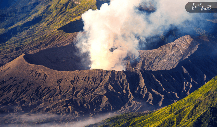
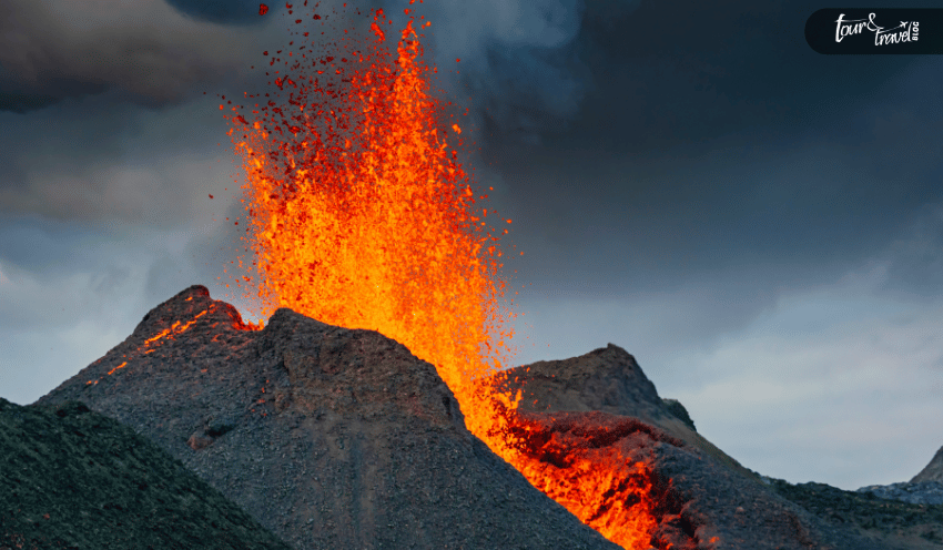
The wild heart of Katmai National Park harbors 14 active volcanoes. This national park of around 5 million acres surpasses the magnificence of the Grand Canyon National Park, and kayaking, canoeing, and hiking here are one-of-a-kind experiences. 

One of the oldest national parks, Katmai National Park, was established in 1918. Novarupta Volcano eruption on 6th June 1912 was destructive, and preservation of the habitation around Mount Katmai was crucial.  

The National Park Service website says, 

Lasting three days, the largest volcanic eruption of the twentieth century exploded June 6, 1912, from a new volcano, Novarupta. In the process, it created Katmai caldera and the Valley of Ten Thousand Smokes. Not only have the 1912 events remained scientifically important ever since, but also the 1912 deposits continue to provide insights about volcanic and magmatic processes that impact us and the land we live in.” (Source

Today, this national park is a living account of human history, and it is the home for brown bears and salmons. It is also one of the most popular destinations for volcanologists because it’s still active. Further, it has a handsome number of visitors every year, and in 2023, the number of footfall was 33,763. (Source

Do you also want to explore this magnificent volcanic landscape? Let me be your guide. 

Why Are So Many Volcanoes In Katmai National Park?  

With “50 discrete volcanic vents,” Katmai National Park is the center of attention of many. But why does it have so many volcanoes? 

Volcanoes in the Aleutian volcanic arc and Katmai National Park are part of the Pacific Ring of Fire. “The Ring of Fire is home to 75% of the world’s volcanoes and 90% of its earthquakes.” (Source

Many call the Ring of Fire the Circum-Pacific Belt, and many tectonic plates meet here. Due to the constant movements of these plates (especially the subduction of the Oceanic Pacific Plate under the North American Plate every year), volcanic eruptions and earthquakes take place here.  

Along with the eruption of  Novarupta-Katmai in 1912, there are also records of the eruption of Mount Trident from 1953 to 1974.  

The latest volcanic eruption in Katmai happened with the venting of Fourpeaked Volcano in 2006. Here is an excerpt from a report published on the 2006 volcanic eruption of Fourpeaked Volcano.  

On September 17, 2006 Fourpeaked Mountain, a glacier-clad stratovolcano with no known Holocene activity, produced a plume of steam, ash, and SO2, which rose to 6000 m above sea level. The plume was observed by eye-witnesses, seen on weather radar, and also appeared in SO2-sensitive satellite imagery. Concurrent with the plume, regional seismic stations recorded a swarm of volcano-tectonic earthquakes while an atmospheric infrasound signal was recorded 800 km away. Air and ground reconnaissance revealed a linear series of vigorously steaming vents in the summit glacier, stretching about 1 km down the north flank of the volcano.” 

So, are you ready to know about the active and rugged volcanoes in Katmai National Park. The next section gives you a detailed overview.  

Know The Volcanoes In Katmai National Park 

Know The Volcanoes In Katmai National Park 

Volcanoes erupt for a short span if you study the entire timetable of a volcano. However, the eruption is only the outcome of activities that take place for years or even centuries. Similarly, the volcanoes in Katmai National Park have faced long intermittent periods between the occurrences of small and big eruptions.  

Further, the volcanic activities and earthquakes taking place in Katmai due to tectonic movements have a major impact on human lives across generations.  

Here, I present a brief overview of a few volcanoes out of the 14 in Katmai. 

Mount Katmai 

Mount Katmai has recorded the highest explosive incidents in the Katmai volcanic cluster. Active for over 70,000 years, the two cones of Mount Katmai were beheaded due to the caldera collapse in 1912.   

The eruptive products of Mount Katmai are varied in their compositions, including basalt and rhyodacite.  

Mount Griggs 

Mount Griggs, the tallest peak in the district, is 2,530 m tall. Despite having young lava flows, some of the deposits in Mount Griggs are 290,000 years old.  

The volcano is still active and you will get to see the yellow sulfurous steam around its summit.  

Trident Volcano 

Trident Volcano is one of the older volcanoes in Katmai. From 1953 to 1974, Trident Volcano had many eruptions. However, the highest and the central volcanic cone of Trident Volcano has been lying dormant for around 10000 years.  

Mount Mageik 

Mount Mageik has four discrete eruptive centers covered with snow. However, glaciers have caused severe decay in three of these lava centers. It is a younger volcano in Katmai, with its lava aged between 4,000 and 93,000.  

The last eruption of Mount Mageik happened 2500 years ago. It caused a crater between two Mount Mageik summits. Today, the crater is filled with an acid lake, exuding steam curls.  

Alagogshak Volcano 

Alagogshak stands at the southwesternmost corner of the Katmai volcanic cluster. It is also the oldest in the Katmai family of volcanoes. The lavas in this volcano are 40,000-680,000 years old.  

Peak 6875, Snowy Mountain  

Peak 6875 is a young dome made of dacite lava. The scoop-shaped peak looks like a natural amphitheater.   

Spectacular Landscapes Created By Volcanic Activities In Katmai National Park  

The volcanoes in Katmai have created some interesting landscapes, and their activities have encouraged geologists to explore the possibilities. Nonetheless, the Valley of Ten Thousand Smokes is the most prominent volcanic landscape in Katmai.  

It is the work of the largest volcanic eruption in the 20th century. The Novarupta Volcano eruption on 6th June 1912 created this valley.  

There are various exciting destinations in the Valley of Ten Thousand Smokes. For the geologists and people studying volcanoes, Novarupta is the ultimate destination. The dome causing the massive eruption in 1912 still carries warm steam.  

It is also the most colorful place in the valley, thanks to its kaleidoscopic views caused by the deposition of ash, pumice, and other minerals.  

Another popular destination in the valley is the Buttress Range Ridge. Here, you will catch a glimpse of the extensive wildlife in Katmai. Along with the bears, you will also find ptarmigan, ground squirrels, and caribou.  

Other fascinating spots to explore in this valley are Katmai Pass, Southwest Trident Lava Flows, Knife Creek Glaciers, Mount Katmai Caldera, Mageik Lakes, etc.  

Did You Know? 

  • Katmai has the largest population of protected brown bears in North America. 
  • It is home to around 2000 creatures. 
  • Robert F. Griggs, a botanist who named Valley of Ten Thousand Smokes, played an active role in designating Katmai as a national park. 
  • Dumpling Mountain offers the best view of Katmai National Park. 
  • The annual Fat Bear Week in Katmai is a tournament-style competition, and online visitors can choose the winner of the tournament through voting. 
  • Katmai National Monument was established in 1918. The redesignation of the protected and expanded area as a National Park happened in 1980.  

Final Words  

Active volcanoes add to the spectacle of Katmai National Park, and they attract the most adventurous souls across the globe.  

The volcanoes are part of the Pacific Ring of Fire, and they have an eruptive history, with the last incident occurring in 2006.  

AOV, or the Alaska Volcano Observatory, is in charge of monitoring the activities of these volcanoes. It also records the incidents of eruptions from dedicated monitoring stations. Two webcams are also installed at Fourpeaked and Katmai for continuous vigilance of the volcanic landscape.  

So, are you ready to visit Mount Griggs, Mount Katmai, and other volcanoes in Katmai National Park? Do you want to have an exciting encounter with wildlife? Don’t forget to share your experience with us!  

Katmai National Park FAQs  

How To Explore Katmai National Park? 

You cannot reach Katmai National Park by road. You can take a floatplane from Kodiak, Anchorage, or Homer. Further, you can take a boat or floatplane from King Salmon. 

Both routes lead to the Brooks Camp shore.  

What Is Special About Katmai National Park? 

Katmai National Park is known for its active and extensive volcanic landscape. It has 14 volcanoes. Further, it is the home to around 2000 species, including brown bears.  

You can enjoy your time here by hiking through the trails or boating or canoeing.  

What Type Of Volcano Is Katmai Mountain? 

Katmai Mountain is a stratovolcano and it had two big cone-shaped volcanoes. The caldera collapse in 1912 beheaded the two cones.  

What Wildlife Is In Katmai National Park? 

Brown bears are the most popular animals in Katmai National Park. In fact, the national park has the largest population of protected brown bears in North America.  

Moose, gray wolves, sea otters, and humpback whales are fascinating animals here. Overall, it is home to around 2000 species of creatures.  

What Type Of Trees Are In Katmai National Park? 

Sitka spruce, alder thickets, and willow are popular trees in Katmai. You will also find plants like lowbush cranberry, cow parsnip, labrador tea, and watermelon berries here.  

Reference: 

National Park Service: “Since 1916, the National Park Service has been entrusted with the care of our national parks. With the help of volunteers and partners, we safeguard these special places and share their stories with more than 318 million visitors every year. But our work doesn’t stop there.” 

Harvard University: “Harvard experts, researchers, and leaders all around the globe make contributions—from public health to conflict resolution—that transcend borders, forge connections, and strengthen communities.” 

National Geographic: National Geographic is a “world leader in geography, cartography and exploration.” 

Also read

Share on Social Media

Meet Sibashree Bhattacharya, a travel enthusiast who has a decade-long experience in transcending virtual barriers with her words! Her deep love for travel is apparent from her travel escapades to the mountain, often taking her readers on a journey, her words acting as Portkey! Fun fact: Sibashree loves to dive deep into the history of the places she is about to visit, making her travels even more wholesome. If you were wondering how her articles are not short of time travel, this answers it!

Leave a Reply

Your email address will not be published. Required fields are marked *

title-img Related

READ MORE how far is russia from alaska

Bridging Continents: Unveiling The Mystique Of Russia And Alaska’s Proximity!

BY  sagnika Sep 20, 2023

Did you know that the United States took Alaska away from Russia? Do you know how far is Russia from Alaska? The two Diomedes Islands, belonging to the USA and Russia, have a mysterious relationship due to their standard time and geographical features. Read the article to uncover the truth behind the mysterious relationship! The two largest countries worldwide, the United States and Russia are 21 hours apart. Alaska is situated nearest to Russia, being a state of the U.S. The Bering Strait is the geographic point between the borders of Russia and the United States! Want to learn more about this point? Keep reading. Isn't it weird that Little Diomede residents depended on helicopters for food? Marine beings play an important role; hence, I will highlight the significance of aquatic animals in the mystery. Bridging Continents: Unveiling The Mystique Of Russia And Alaska's Proximity! How far is Alaska from Russia? You have to read the article to learn about how the two nations, the United States and Russia, are claiming their rights on the two Diomedes Islands. Guess the interesting aspects of the Island and why it is all mysterious. The time and the geographical differences between the two points of the Islands make you question the International Date Line and the American-Russian maritime border. Being a day ahead by a day of the Big Diomedes as compared to Little Diomedes makes you question the time zone concerns! It is quite curious to know how the islands have been named and their significance concerning the history of Alaska and Russia. There are Alaskan natives to be considered among all these political, geographical, and time zone aspects. Want to know the distance between Alaska and Russia? Separated By Geography And United By Mystery! Want to know how far is Russia from Alaska? The closest geographical connection between Russia and Alaska is the Diomede Islands, which are 2.4 miles apart. Water is separating the two Islands, in another way, separating the two countries. The two islands are the extremes of the two countries, thus claiming the big and the little Diomedes Islands as the symbolic sentinels. The two countries have a history of heroic explorers who have sledded, kayaked, and swum across the distance. A 2.4-mile distance between the two Islands is connected with the water body, the Pacific Ocean. With a very rocky history, the Islands share an indigenous group of people; however, it needs to be considered more important by the nations. The Bering Strait The narrowest point between the Seward Peninsula (U.S.) and the Kamchatka Peninsula (Russia) is 55 miles, separating Alaska from Russia. This waterway was discovered by a second European, a Danish explorer, Vitrus Bering, who inspired the Berling Strait. The first explorer of this frigid waterway was the Russian explorer Semyon Dezhnev! Vitrus Bering named the place Greek Christian Saint Diomede because he discovered the Islands on 16 August 1728. This day coincides with the feast day. Hence, the Island was named the Big Diomede Island and the Little Diomede Island. The Bering Strait is significant because it is the only marine gateway that allows mass migration of gray whales, bowhead, and beluga. It is known as an important ecological zone for marine animals. Seals, walruses, fish, and other marine animals can access nutrient-rich Arctic Ocean environments through this zone. The Big Diomede Island The Ratmonov island is towards Russia and is also claimed as Russian Island, which is the nation's easternmost point. It was in 1867 that the Alaskan Territory was sold on a $7 million sale. During the Cold War and World War II, the Island was a perfect location for the outposts of the Soviet military. The rocky Island is flat and houses up to 11 species of birds with rough weather with clouds and storms. The Little Diomede Island Little Diomede Island is the smallest of the two Islands, with a population of 80 to 100 citizens! You can only access the Island by waterways or through one heliport in town. They receive their supplies from mainland Alaska as these are the only two ways! During the harsh winters, the Island is covered with thick ice sheets, so the locals must carve the ice sheets to create landing zones. It is situated in the eastern area. The Time Difference Between The Two Islands! So, if you are wondering, how far away is Alaska from Russia? The International Date Line (IDL) separates the two Islands, Big Diomedes Island and Little Diomedes Island, which makes the time difference so apparent! The Big Diomedes Island is known as Tomorrow Isle as it is 21 hours ahead of time. So, wanna know how far from Russia to Alaska? The Little Diomedes Island is known as the Yesterday Isle because it was further back then. Overall, the two islands are separated by 23 hours. The 9 hours have been adjusted concerning daylight saving time! Apart from that, 12 hours have been established for managing the timezone of the Island along with the nations! So now you have got the answer to your question, how far is Russia from Alaska! Alaska Was Taken Away From Russia! It was in 1867 that Alaska was purchased from Russia by the United States, thus becoming a political separation. During this time, a new border was drawn across the two islands. During the Cold War, the section of the Bering Strait was nicknamed the "Ice Curtain" between the two Islands. The islands are situated south of the Arctic Circle, about 52 miles apart. Read More: Six Important Factors To Consider Before Planning Alaska Fishing Trip The Politics Of Diomede Islands! The Indigenous Inupiat people claim the two Diomedes Islands as theirs; however, both the nations, the USA and Russia, have disrespected these claims. The two countries have made national declarations regarding the Diomedes Islands as their extreme points. The Bering Strait can become a bottleneck for ship traffic that will pollute the ecosystem. The narrow area acts as a pathway with a fragile ecosystem with oil spills and engine noise. Finishing Off… So, to answer, how far is Russia from Alaska? For the answer, read the article! When learning about the political history of Alaska related to Russia and the USA, there is the question: How far is Russia from Alaska? It was important to understand how close the countries are, and yet there is a time gap between them. The interesting thing was naming the Islands and how it impacted people's perceptions. Apart from the mystery, the concern is how nobody is giving importance to the indigenous people of Alaska! The governments of both Russia and the United States are not concerned about the people. Comment to let us know your perspective on the time difference between the Big and Little Diomedes islands! Read Also: These Are The Closest Beaches To Ohio That You Need To Go For A Dreamy Vacation! Paradise Found: Exploring Manuel Antonio, Costa Rica’s Tropical Gem! Check Out These Beaches That Are Closest To Tennessee’s Knoxville!

READ MORE When can navigation rules be overlooked

When Can Navigation Rules Be Overlooked?

BY  Nabamita Jan 5, 2023

If the question arises of when can navigation rules be overlooked, then the answer is that they should never be overlooked. However, there are moments when you only have the option to ignore these rules. Certain situations and groups can ignore and overlook these rules whenever they want. To know them, too, scroll down below. What Do You Mean By Navigation Rules? For every water vessel traveling through water bodies, specific rules are enforced to see their safe travel. These rules are like the traffic rules, but except for roads, they are for the waterways and waterbodies. These navigation rules ensure the safety of the vessel and the passengers onboard from dangerous rocks, shallow waters, and reefs. When Can Navigation Rules Be Overlooked? The navigation rules are set in place to ensure safe and secure travel on water, but there are moments when these rules need to be followed sometimes. So the situations that can force the sailors to ignore the navigation rules are as follows. Crossing Dangerous Waters When you are crossing turbulent and dangerous waters, with the people on board being unsafe, the navigation rules can be overlooked; their priority is to protect the passengers. When it comes to sailors, during storms and dangerous turbulent waters, they are not bound to follow the navigation rules. They can easily overlook them. To Avoid Immediate Danger Who may depart from the navigation rules? The operators may need to depart from the navigation rules while trying to mitigate imminent dangers. While traveling over waters, danger can happen anywhere, and at any point, so paying proper attention to the navigators is essential. They are trained for any sudden changes in water and air direction. So if travelers and navigators predict something dangerous, they can ignore all the navigation rules. This is how they can keep the onboard passengers safe. When A Vessel Has Little Maneuverability If the captain and crew feel like the vessel is going through a little maneuverability, then they are allowed to overlook all the navigation rules for boats. It is more important to keep the passengers safe than to travel in a hazardous environment. When The Sailor Is Inexperienced It is important that navigators and sailors should know how to navigate their way around the water. That way, they don't end up endangering the lives of others on the vessel. To save time, these inexperienced sailors sometimes disregard all the maritime navigation rules that are in place. When can navigation rules be overlooked? – if you are a navigator or sailor, look back to your novice years. Sailing In Poor Visibility When a sailor is sailing in a situation with poor visibility, then the rules of navigation are ignored. If the radar is not working properly, then the navigation rules can be ignored. When climatic situations make it difficult to see, and visibility becomes a big issue, navigation rules are entirely ignored. That is when experience and intuition come into action. What Are The Basic Rules Of Navigation? The "rules of the road at sea," or navigation regulations, apply to all boats. These regulations clearly indicate when to pass, approach, yield, and overtake other boats. The International Rules for Preventing Collisions at Sea (ColRegs) and the fundamental rules of the water should be familiarized with by all boaters, regardless of the size of their vessel. For other masters to see your intentions, you should always move in a clear and deliberate manner. Never assume that the captain of a different boat will follow the rules; always be ready to prevent a collision. To prevent collisions with other boats, the Colregs provide clear signals for passing, approaching, giving way, and overtaking. These are the rules for boat traffic. Rules: Here are some of the basic rules of navigation that you need to be aware of when at sea: When navigating a river or channel, a boat must always operate on the starboard (right) side. You have the right of way when a boat approaches from your starboard (right) side. You have right of way if you approach another boat from the starboard side. However, you must act to avoid collision if the other boat does not yield. Each boat changes course to port (left) and changes course to port (right). Always assume that this is the case. You have the option of overtaking a boat from either side of the one you want to pass. But you have to stay far away from the boat you're passing. This is true for sailboats as well as powerboats. The sailing boat with the wind on the port side must give way when there are two boats with wind on opposite sides. The boat to windward must yield to the boat to leeward when both boats are facing the same direction. Sail usually triumphs over power. However, this isn't always the case. Due to their size, larger vessels, like ferries and container ships, are difficult to maneuver. By giving larger vessels a wide berth, masters of other boats, including sailboats, should always use common sense and good seamanship. What Are The Consequences Of Overlooking Navigation Rules? For those asking, "when can navigation rules are overlooked," it is essential for you to know that there are severe consequences for not following the rules. And some of the effects that may befall you if you overlook the navigation rules are listed below. They are endangering the environment. The ship and its onboard passengers can get lost at sea. With overlooking the navigation rules, a shipwreck is a strong possibility. A hazardous environment on the ship can create a dangerous place for the people onboard. This can lead to health issues and even death. The vessel and passengers can face legal trouble for not following the navigation rules. Read More: What Are The Different Types Of Cruises (And How To Choose The Right One For You)? Who May Depart From The Navigation Rules? The navigation rules are set up for everyone's safety and security, so not following them can be risky. However, some people ignore these rules to stay safe and do their work. Please scroll down to see who these people are, who can overlook the navigation rules whenever they want. Pirates And Illegal Fishermen For pirates, the rules of navigation don't apply. They are beyond any rules, which is why they are pirates. They do this so that law enforcement can't catch them, and they can run away free. That is the same for fishermen who are fishing illegally. Those In Imminent Danger The recent enforcement requires maritime law that the answer to the question of when navigation rules are overlooked is during imminent danger. Escaping a dangerous situation is much more important than abiding by the law. Read More: What Is Most Likely To Cause Someone To Fall Overboard? Research Vessels Marine life science research vessels can easily deviate from the navigation rules. The study is based on marine life and the ocean, so they need help to go by the navigation rules. Those Experiencing A Mental Health Crisis If someone goes through a mental health problem on a vessel, they can let go of the rules. Instead, they don't tend to follow them. In addition, if someone is emotionally distraught or under the influence of alcohol or drugs, they might not follow the rules. Wrapping Up! Now that you know the situations and people who tend to ignore the navigation rules, your question of when navigation rules can be overlooked is answered. In these situations, people don't regard such laws when they travel on international waters. So if you want to know more about this topic, we have more articles on our website, so browse through them, but first give us a like and comment below. Read Also: The Ultimate Hotel Tipping Guide Top 10 Best Beaches In Florida For Families Speed Boat Miami Tour – Sightseeing And Entertainment

READ MORE best time to visit fiji

What is the Best Time to Visit Fiji for your Next Vacation? 

BY  sagnika Mar 29, 2025

When planning to go on a trip next, I would say Fiji should be on the top of your list. With unexplored islands, the unique features of these places highlight the natural beauty of the place. Offering one of the most beautiful and secluded locations in the world for vacation.   Did you know that it is in the Fiji Islands, that the movie Cast Away was shot on the mountainsides of Mamanucas? Imagine the place and visit to make memories. Let me share with you the best time to visit Fiji and enjoy the most.   You should carry the best travel credit card so that you can use it if needed. At the end of the day, you must have backup for money if the cash you are carrying finishes.   What is the Best Time to Visit Fiji for your Next Vacation?   If you are wondering when is the best time to visit Fiji, plan your vacation between October to February. Apart from experiencing some of the coolest festivals, you also get to experience adventurous water sports.   Some of the most revered tourist' places in Fiji Island will pull you towards its beautiful natural and spiritual elements. For example, if you want to own natural pearls, you should visit Savusavu with crystal clear water.   Further, you can visit Levu, Mamanucas, Viti Levu and other places to experience natural botanical gardens, untouched island areas, secluded thriving with greenery and lush water. Let me share with you in more details when you should visit Fiji and what you need to do!   Best Time to Visit   If you are wondering about when to visit Fiji, let me share with you the best time to visit. From May to October, you can visit Fiji as it is considered the peak time with warm and dry weather. Just like death valley, visiting Fiji is important when it comes to the right time!   Additionally, the temperature is also moderate ranging from 20 to 30-degree Celsius. Yes, the tourist crowd will be quite heavy with a vibrant atmosphere all around! If you want to avoid the crowd, the time for you to visit Fiji is between the month of November to March.   It is off-season, and you will find it ideal to explore the islands with much fewer people around. However, you might not get to attend cultural events or festivals that are the life of the party during the peak season. You might experience severe temperatures during this time which might make the whole process difficult.   The moderate season to visit Fiji is from the month of April to May. It is ideal for beach activities along with some leisure time that you can spend.   Things to Do   There are several things to do when you visit Fiji especially during the peak time. From exploring untouched islands like Mamanuca to doing several water-based sports activities like diving, snorkeling and exploring other attractions like the Garden of the Sleeping Giant.   Island Hopping   One of the most important things to do in Fiji is island hopping. You can explore different types of experiences such as walking along the pristine beaches and seeing the vibrant coral reefs. Yasava Island is known for its beautiful resorts on its stunning beaches.   You can also experience Fijian culture while hopping Island because everyone is very communal, helping each other in village and family. Eat their food like Lovo while dance and music are an integral part of their tradition.   You can experience “meke”, Fijian dance, and music which ranges from performance, athletic dance, and war dance. Let's not forget to visit Mamamuca Island where you can kayak around thus, exploring lagoons and hidden coves.   Water Activities   You can take boat tours exploring different islands and thus, doing different water sports. Snorkeling is one of the most popular activities to do as water sports when you visit Fiji on vacation. Use a mask when snorkeling and then enjoy underwater scenery and life!   You also wear a wetsuit, fins, and a tube, snorkel allows your face to be covered while you can breathe. Another water sport, surfing, is an activity where you ride a board on the waves breaking it. The sport has its roots in pre-modern Polynesia and Hawaii.   Paddleboarding is another similar water sport like surfing where you stand on a board and use a paddle to propel yourself through the water. It looks very much like an offshoot of surfing enjoying riding the waves. Another water-related activity is recreational diving where you go underwater and then come up for water!   If you are planning to experience a relaxing activity where you have the time to check out the beautiful scenery around you, you should Kayak. On the kayak, you can explore different caves, lush forests on the edge of the waterbody and others.   Hiking with Adventure   If you are an adventurous person but are more into natural beauty compared to sports, you hike! The adventure waits for you as you explore the waterfalls, mountains and forests of Fiji, appreciating the beauty of the exotic places.   Waterfalls   If you love waterfalls, go to Vanibauloa waterfall for a hike and experience the adventurous landscape. You must discover the beauty of the place along with making memories on your Fiji vacation. I feel Fiji is one of the best places to visit in February!   Another significant waterfall that you must visit if you are planning to go on a trek is Tavoro falls, also known as Bouma falls, which is stunning. During peak time, you will find a lot of crowds here as it is a tourist favorite.   Mountains   The highest peak in Fiji, the mount Tomanivi can be hiked as it is moderate level difficult however, you will need a guide. The trek will require about 4 to 5 hours and will need you at the top of your physical and mental fitness. Enjoy the spectacular view when you are on top!   A challenging trek across mount Batilamu offers you a rewarding view however difficult it is. There are diverse landscapes across the trails that you hike upwards so, keep medication with you, drink water, stay hydrated and stay cautious.   Rainforests   Love lush forests? Visit Colo-i-Suva Forest Park which offers opportunities to see giant trees and various kinds of birds. The lush forests offer you breathtaking views across the trails. You also should not miss the Bouma National Heritage Park located in Taveuni, which features beautiful rain forests.   The opportunities are endless, and you can easily camp here. However, you need to be a bit aware during the rain. There will be insects and poisonous animals, so please be cautious before you visit and carry ointments for allergies.   Leisure in Nature   You can soak up the sun at the beautiful beaches in the Fiji Islands with a drink and a book in your hand. Don't forget to apply sunscreen properly every two hours and have your sunglasses and hat to protect you from the sun. one of the most exotic places to travel when you are in love with nature!   Soak up the sun but carefully thus, unwinding properly on your vacation. You can also go for a swim in the ocean or at the resort pool, thus relaxing properly. You will be facilitated with several other activities like having dinner alongside the beach, going for a stroll, spending quality time with your friends or partners with whom you are on vacation!   Wrapping Up!   Now that you know the best time to visit Fiji after you have read the article, what do you think is the necessary things to do. I have shared several fun activities which you can explore and make your trip more memorable.   Comment on what you think is the best time to visit in consecutive with the peak time. Read the blog and understand the things you need to consider before you plan your trip to Fiji.  Also read Top 10 Most Popular Paraguay Food That You Must Try. Top 13+ Famous Wonders Of India That You Must Visit. Top Tips For Motorbike Rental In Phuket – A Guide To Exploring The Island On Two Wheels.