It’s hard to imagine that a watery wonder and a versatile geological place exist so close to the Californian Mainland. Yes, we are talking about the Channel Islands National Park.
Rich in diverse flora, fauna, and wildlife, this national park, consisting of five islands, is a hiker’s favorite. The hiking trails on each island are different. For example, the trails in Anacapa are flatter, and they get steeper as you visit Santa Rosa or Santa Cruz.
Also, as a critical marine sanctuary, this national park offers an amazing experience for people interested in aquatic pursuits. Boating and scuba diving here are activities that an adventurous soul will surely look upto.
Are you ready to pack your bags and hit the trails? Let us join you.
Channel Islands Hikes That You Just Cannot Miss
Hiking trails in the five islands of this national park vary in their difficulty parameters. The trails in Anacapa, Santa Rosa, San Miguel, Santa Cruz, and Santa Barbara are easy (Cavern Point Loop), moderate (Potato Harbor), and hard (Montañon Ridge Loop).
As a hiker, you have to be sure of your physical and mental endurance before you start exploring specific trails. Further, you will encounter many challenges as you explore the hiking trails.
Common perils here include poisonous oaks, scorpions, ticks, wildfire risks, reptiles, and Hantavirus spread by deer mice. To deal with these hazards, you must make the most of the buddy system and, most importantly, be respectful to the wildlife.
However, the pain you have to undergo throughout the journey is worth the dramatic experience the trails offer. It’s time to know about them.
Anacapa Island Hiking
Anacapa Island got its current name from its original Chumash Native American Indian name, Anypakh. This island is made of East, Middle, and West Anacapa islets, and surprisingly, none of these are connected to each other.
Before I introduce you to some of the most amazing trekking trails in Anacapa, let me share some highlights about the island.
Anacapa Island: Things To Know
Anacapa is known for its diverse vegetation, wildlife, culture, and history. Coreopsis and sunflowers come to life after the winter rain, and you can see them from the California Mainland. Anacapa is the largest breeding colony of western gulls in the world. It is also the largest breeding colony of the California brown pelicans, which are endangered species. Chumash Indian people used to camp here thousands of years ago.
Inspiration Point Hike (Easy)
Just a 1.5-mile hiking trail, Inspiration Point offers the most amazing view of the island. Enjoy the sheer contrast created by vibrant wildflowers and the tranquil blue water.
Pinniped Point Hike (Easy)
Pinniped Point hike, which is a 4-mile distance, is known for its sea lion rookery and lighthouse.
Cathedral Cove Hike (Easy)
The 6-mile hiking trail is the best place to see the most amazing rock formations. Here, you will also find beautiful kelp forests, sea lions, sea caves, and birds.
San Miguel Hiking
Hiking in San Miguel is a little tricky as you cannot take the off-trail roads. Further, hiking is only limited to certain spots, as its unique geological features, wildlife, and plants need preservation.
Caliche Forest Hike (Hard)
Despite its difficulty level, Caliche Forest is the most exciting trail to hike in San Miguel. This landscape of five miles has naturally calcified prehistoric vegetation. So, the entire area has the most surreal “fossilized” appearance.
A visit to this trail is like a time travel, and the feeling is, at times, eerie.
Cuyler Harbor Beach Hike (Easy)
Enjoy the pristine beauty of the 2 miles of white sand stretch and observe the adorable seals. Take a walk along the beach to find the sand running into the rocks.
Cabrillo Monument Hike (Hard)
The distance of this trail is 2 miles. However, the steep climb makes the hiking experience very strenuous. You will visit the monument of Juan Rodriguez Cabrillo, the first European to explore this island.
Santa Cruz Island Hiking
Santa Cruz, or the La Isla de Santa Cruz, is the land of the Sacred Cross. Known as Mini California, this island has endless bounties to offer. From the Transverse Mountain ranges to the deep valleys, canyons, and beaches! You will meet the most diverse geological picture here.
Here, I will talk about some of its most prominent hiking trails. However, before that, let’s share some interesting facts about the island.
Things To Know About Santa Cruz Island
Size: 96 Square Miles (The Largest Of The 5 Channel Islands) Plant Species: 600 Plant Communities: 10 Landbird Species: 140 Land Mammal Species: 11 Cultural History: More than “10,000 years of American Indian habitation, 150 years of European exploration”
Cavern Point Loop Hike (Easy)
Cavern Point Loop is a popular destination for hiking, kayaking, and seasonal whale watching. As you trek through the 2 miles route, you will get to see the most magnificent coastal vistas.
Potato Harbor Hike (Moderate)
The harbor gets its name from its unique oval or potato shape. The cliffs here are steep and dangerous. The bright white sedimentary rocks (diatomaceous earth) here are formed by diatoms or single-cell sea plants made of silicon dioxide.
Diatomaceous earth has wide applications in filtering water.
The Giant Kelp Forest is another attraction in Potato Harbor. Kelp is a nutrient-rich and fast-growing algae that helps build a rich marine ecosystem. The California sea lions here will make your visit to the island most delightful with their playful nature.
Montañon Ridge Loop (Hard)
Montañon Ridge, with Montañon Peak and High Mount, is the highest ridge on the eastern side of the island. This trekking trail is only for experienced hikers.
The total distance of the hiking trail is 10 miles.
Santa Barbara is an island for endless outdoor pursuits like hiking, camping, fishing, and watching wildlife.
Further, Santa Barbara is the island to be if you want to explore the local vegetation. If you visit the island in spring and winter, you will meet the most colorful wildflowers here. Also, delightful flowers like poppies and verbenas are in full bloom in the summer.
Do you want to hike on this island? Here are some trails for you.
Lizard’s Mouth Hiking Trail (Moderate)
You have to take just a quarter-mile walk off West Camino to find this hiking spot. It’s also a favorite Santa Barbara destination for picnics.
The place gets its name from the rock formation resembling a lizard’s open mouth. This place is picturesque and perfect for photoshoots.
La Cumbre Peak (Diificult)
With the highest elevation of 1215 m, the La Cumbre Peak (the highest in Santa Barbar) hike is full of challenges. However, this trekking trail is full of highlights like the Cathedral and Arlington Peaks, the coastline to the sea, etc.
San Roque Creek (Easy)
The San Roque Creek trail is located in the 25-acre recreation area in the park. The area is called Stevens Park. With just an elevation gain of just 93 m, it is an easy trail to explore, and you can have a great time walking with your dogs here.
Santa Rosa Hiking
The hiking trails in Santa Rosa are a combination of flat and steep terrains. The trails to the Water Canyon Beach are flatter. At the same time, roads to the Black Mountain are strenuous.
Water Canyon Campground Hike (Easy)
This 3-mile hiking trail is one of the easiest routes in Santa Rosa or all over the Channel Islands. Enjoy a gala picnic with your group here.
Water Canyon Hike (Moderate To Strenuous)
The perennial canyon and the local vegetation make the water canyon hike the most amazing experience. If you want, you can also follow the stream bed and get wet.
Black Mountain Hike (Hard)
With a distance of 8 miles, this trail offers the most amazing views of the mainland and San Miguel, Santa Cruz, and Santa Rosa islands.
Did You Know?
By 1928, many fossils of pygmy mammoths were found in the Channel Islands. Further, almost a complete skeleton of an adult pygmy mammoth was excavated on Santa Rosa Island in 1994.
These mammoths were very similar to the Californian mainland mammoths. However, they evolved and got smaller in size to accommodate on the Channel Island. Worldwide, these mammoths are known as Channel Islands Pygmy Mammoths.
Final Words
Channel Islands National Park had 328,746 visitors in 2023 (Source). Despite being close to the California mainland, these islands offer tranquility, and with many places to visit and activities to do on the five islands, you will surely be spoilt by the choices at this national park.
On all the islands, you can trek, fish, camp, and take part in many water sports. However, two of the most coveted activities in these parks are hiking and exploring marine life. The variety you find here in whales and other marine mammals can be a close match to the vibrant marine ecosystem of Wrangell-St. Elias National Park.
In this guide, I have highlighted trekking through the trails in this national park. Do you want to know more about its wildlife and marine ecosystem? Share your thoughts in the comment below.
Channel Islands National Park FAQs
Which Island Is The Best To Hike In Channel Islands National Park?
Anacapa and Santa Cruz islands are great for hiking in the Channel Islands. However, if I am to share my opinion, Anacapa will be my silent favorite.
The trekking trails here are way easier in Anacaopa than in Santa Cruz. So, irrespective of your expertise level, you will be able to hike the entire island in a day.
Also, as the trekking journey here is less arduous, you will be able to enjoy the surrounding scenic beauty even more. You will meet the most adorable sea birds, sea lions, and seals. Also, if you are lucky enough to be in these mountains during spring or late winter, you will find the mountains replete with colorful wildflowers.
Inspiration Point, Cathedral Cove, and Pinniped Point are some of the highlights of hiking expeditions in the Anacapa Islands.
What Is Special About Channel Islands National Park?
Channel Islands National Park is special because it is a paradise for trekkers, nautical surfers, and wildlife explorers.
Its San Miguel, Santa Rosa, Anacapa, Santa Barbara, and the largest, Santa Cruz islands have many hiking trails with Transverse Ranges.
Further, half of the national park is under the ocean, and you will find six nautical miles of water around it. So, it is a critical marine sanctuary and a great place for scuba diving, boating, and other aquatic pursuits.
In addition, its wildlife is mesmerizing, with the presence of animals like island foxes, spotted skunks, salamanders, whales, California sea lions, sea otters, dolphins, giant black seabass, and more.
Which Island Is The Largest In Channel Islands National Park?
The largest island in the Channel Islands National Park is Santa Cruz, which is also known as the epitome of California. Its size is 96 square miles.
Its geology is versatile, with Transverse Ranges, fault systems, springs, streams, and canyons. You will also come across sea caves, beaches, and coastline cliffs. Among the sea caves, the Painted Cave is the most prominent one with lichens, algae, and colorful rocks.
Sibashree is a travel, culture, and leisure writer who has been writing since the age of 12 and professionally since 2014. With more than a decade of travel writing experience and journeys across India and several parts of the world, she brings a deeply personal and thoughtful perspective to her work. A student of English Literature and Mass Communication, Sibashree has always viewed travel as more than movement — for her, it has been a way of understanding people, cultures, and herself. Her passion for spiritual exploration has also led her to many unusual and meaningful destinations over the years. Outside of writing, Sibashree enjoys watching European cinema, reading about global politics, and reflecting on the stories hidden within everyday places.
Saudi Arabia has started providing the eVisa, which is mainly a visa for tourists. This change has started attracting a lot of Muslims, especially from the UK.
Different types of packages are being offered by the Islamic Travel Agency for people holding British passports.
They are providing various deals to visit Saudi Arabia. Islamic Travel Agency is also providing Umrah packages with a short trip to Saudi Arabia for British Muslims.
This deal is a 2-in-1 combo for pilgrims, 1 they can perform their Spiritual Pilgrimage, and secondly, an international trip. Almost every visitor travels by air to come to Saudi Arabia.
There are a bunch of International airports present in major cities of Saudi Arabia, like Riyadh, Jeddah, Tabuk, and Dammam.
The airport that you choose to arrive at depends on the route of your flight and the places that you plan on exploring.
But traveling from the UK directly to Saudi Arabia can be tricky if you don’t know about the tips and tricks. So, in this blog, I have brought you a complete cheatsheet to travel to Umrah on a tourist visa UK.
So, what’s the wait for? Come dive right in!
Hot Spots In Saudi Arabia
Coming from a former traveler who has spent a month traveling through Saudi Arabia, the must-visit places that were the highlight of the trip are mentioned below.
1. Jeddah Al Balad
There are certain historic, cultural, and modern aspects of the country blended seamlessly together in the name of Jeddah. Jeddah city, situated on the coast of the Red Sea, is one of the major tourist attraction spots in Saudi Arabia. It consists of one of the major international airports of Saudi Arabia, as well as the latest digital mosque, established in 2024.
2. Al Wa’bah Crater
The Al Wa’bah crater, which was formed due to a volcanic eruption, is a historical site near the premises of Ta’if. This crater has a diameter of almost two kilometers. At the bottom of this crater is a white residue, which is believed to be a layer of white sodium phosphate crystals. The bottom of this crater is sometimes also known as the Salt Lake.
3. Al Ula’s scenery
In ancient times, the walled city of Al Ula was discovered as an oasis. This land had greenery and plenty of water. Many rocks, like the famous elephant rock, are present in the city of Al Ula. This site is a famous tourist site because of its unique structure and beautiful scenery.
Apart from all the sites and scenery of this country, the most beautiful sight was of the locals and their hospitable nature. The way in which the local people of Saudi Arabia help tourists and show cooperation was unmatched. A lot of locals were really fluent in English, and they welcomed us with grace and warmth.
Why Do You Need A Tourist Visa UK?
Saudi Arabia has started to offer tourist visas to almost 66 different countries, and it is not crazy expensive either. This visa also covers health insurance, which ensures to helps the visitors to access healthcare at any time during their stay.
What Is The Best Time To Visit Saudi Arabia?
It is a well-known fact that most of the area of Saudi Arabia is desert. Travelling through the country during summer is like melting yourself down under the sun, so it is recommended to travel during winter to get the whole experience.
Language In Saudi Arabia
Arabic is the language of the locals in Saudi Arabia. For checking the tags while shopping, you can always use the Google translation feature by clicking the picture. Shopkeepers are fluent in English as they have to deal with foreign tourists on a daily basis. If necessary, one can always use Google Translate, as it comes in handy.
Visiting Saudi Arabia During Ramadan
Muslims who want to go for pilgrimage or experience Ramadan in Saudi Arabia must visit during this period, but it is not an ideal time for tourists to head to Saudi Arabia.
This is the time when the flight tickets, hotel accommodation, health insurance, and transport all skyrocket, and it is very expensive to move through the country or enjoy your stay there.
If you are a Muslim and want to experience the true spirit of the holy month of Ramadan, and do the pilgrimage as well.
Then you are in the right place. Islamic Travel Agency is offering a last 10 days Ramadan Umrah package to British Passport holders who want to perform Umrah in Ramadan.
Muslims will find out the true spirit of Ramadan in the Kingdom of Saudi Arabia.
Bonus Tips For Travelling To Umrah On Tourist Visa UK
A pro tip for first-time visitors is to check the hotel management rules for smoking. That is, if you are visiting a Saudi Arabian hotel, do check with the management. So, there are no residues or odors due to the smoking activity of previous people.
If you are someone with a time crunch, then you must travel from one city to another by plane. This way, you can save a lot of time and hassle.
Another pro tip is to book your flight earlier. Moreover, earlier booking can prevent the problem of unavailability of seats or last-minute changes in flight timings.
If you travel by car, you will need a couple of business days to travel from one city to the other. And it will consume most of your time as a tourist.
To make sure that you enjoy most of your trip, you must book a budget-friendly flight. But you’ll still have to book a car at the airport to reach your desired destination.
Some places in the Mediterranean win you over at first glance. Others get more interesting the longer you look. The La Maddalena Archipelago belongs to the second group.
Its beauty is obvious: clear water, pale sand, rugged coastline, and the kind of light that makes the sea look unreal. But what makes La Maddalena stand out is something more specific.
Here, granite, wind, shallow seabeds, and protected coastlines come together to create landscapes that are never merely beautiful. They are precise, dramatic, surprising, and deeply shaped by the way you approach them.
That distinction matters. It is easy to reduce the archipelago to the usual formula: white beaches and turquoise water. But La Maddalena, Italy, is far more varied than that. Its most memorable places are not interchangeable.
Some are defined by rock and relief. Others by light, water depth, and shifting color. Others still by exposure, silence, or the feeling of being far from shore.
To understand what makes La Maddalena special, you have to look beyond the postcard image and notice how each island creates its own visual experience.
What Makes A Landscape Unique In La Maddalena, Italy
For me, La Maddalena, Italy, brings something new every time. Some people say the landscape changing color is the best part. But I like how the sea blends with the land here.
The smooth granite cliffs and naturally made famous sculptures on the granite also attract me. Then there are the hidden coves. Meanwhile, the shallow sea changes its color three times a day.
As it touches the beach, it appears transparent, with a greenish tint at first. After that, the water is pale blue and finally turquoise. On top of that, the flutter of sea breeze will always calm your soul.
Some people say the long, monotonous sea coasts bore them. But I don’t relate to them. I bet they don’t have the perspective to enjoy the sea. I believe the archipelago is not only a beach site. It has traces of age-old geology. It captures the sun and moon differently.
Most importantly, their unique physical forms shape their appeal. Some of them change their shades with changes in light. Others feel remote even within one of Sardinia’s best-known coastal areas. Have you seen all of them?
Caprera’s Granite Landscapes
Caprera is where the archipelago shows its harder, more rugged side.
Some Mediterranean islands feel soft and inviting. Caprera does not. Its identity is built first around rock, then around the sea. The coastline feels carved rather than arranged, with granite formations giving the landscape weight and direction before the water even comes into view.
That makes Caprera an ideal place to begin. It shows that La Maddalena, Italy is not only about bright bays and transparent water. It is also about structure.
Cala Coticcio is famous for the glare in its shallow water. The luminous water at night attracts many tourists. At the same time, the surroundings also leave a spell on you!
The bay is held inside a rocky frame, almost as if it has been cut into the island. The result is not generic prettiness, but contrast: rough stone against brilliant water, solid granite against an unexpectedly delicate inlet.
Caprera also introduces an important difference between the archipelago’s landscapes. Some places reveal themselves immediately. Others feel earned.
Here, arrival is part of the experience. The coast does not simply present itself. It builds tension through dense Mediterranean scrub, pale rock, and sudden flashes of blue.
That is why Caprera is one of the clearest examples of a La Maddalena landscape shaped as much by geology as by the sea.
Budelli And The Shifting Colors Of The Sea
People judge Budelli by the single postcard image they see. But it doesn’t really tell you much about the place.
I feel what makes the place unique is Spiaggia Rosa. It is a popular destination. But if you ask me, people really don’t explore the scenic beauty here. Honestly, what triggers me is the landscape's fragility.
The pink shade of Spiaggia also seems magical. But do you know why it looks like that? The color actually comes from the minor organisms and the fragile, broken shells that lie there.
So you don’t really visit Budelli to chill out. Or have a fun swimming session. On the other hand, this is a destination that makes you pause to enjoy nature.
Around Budelli, the shallow waters and the wider Porto Madonna area create a constantly shifting field of color. Light, depth, and movement do most of the work.
This is where the archipelago's visual intelligence becomes especially clear. The scene is not powerful because it is massive or monumental. It is powerful because it changes.
The sea reflects, absorbs, brightens, and darkens. Budelli becomes less like a postcard and more like a lesson in how color can define an entire landscape.
Spargi’s Wild, Wind-Shaped Character
If Budelli feels fragile, Spargi is something else entirely. It doesn’t try to be subtle.
The island feels more open, a bit harsher in places. The coastline is broken up. To clarify, there are big granite shapes, gaps between rocks, and sudden coves that don’t really ease into each other. There’s nothing smooth or organized about it.
Cala Corsara shows that pretty clearly. It’s not just “beautiful” in the usual sense. It looks worked over. For example, the rock feels it has been pushed and worn down over time.
Moreover, you can see these odd shapes, small pockets of water caught between heavier stones, and uneven edges. It feels like pressure has been part of the process here.
Compared to Budelli, it’s less delicate. There’s less layering, too. But that’s what makes it extravagant. Spargi feels more direct. It doesn’t hide what it is.
At the same time, it’s not untouched. In peak season, there are people everywhere. Boats, noise, and movement are very common. But even then, it doesn’t fully soften. The landscape holds its original self. It doesn’t look postcard-pretty.
You might have partied on the best cruises from Miami. It’s time for a visual treat that will heal your soul, too!
And that’s probably why I love going there. It keeps a bit of that rough edge, even when everything around it tries to smooth it out.
Santa Maria’s Hidden Coves And Sculpted Coastline
Santa Maria offers a quieter counterpoint to the islands that come before it.
Where Spargi is abrupt, and Caprera feels built from mass, Santa Maria is more open, horizontal, and subtle. It is not dramatic in the obvious sense. Its strength lies in a softer, more understated kind of distinction.
The island’s lower profile matters. Because Santa Maria is relatively flat, the landscape opens outward instead of rising around you.
That changes the rhythm of the place. The coastline feels wider, the sea more continuous, and the transitions between sand, shallow water, and open sea more gradual.
Cala Santa Maria captures this character well: fine sand, transparent water, and a feeling of calm that comes not from emptiness, but from clarity and space.
One of the most interesting features is Passo degli Asinelli, the shallow sandy passage nearby. It is the kind of place where geography becomes image.
Santa Maria does not rely on a single dramatic viewpoint. Its identity comes from the relationships between islands, channels, beaches, and soft marine contours.
It may be less theatrical than some of the archipelago’s more famous stops, but that is exactly why it belongs in the conversation.
Why The Archipelago Is Best Understood From The Sea
At some point, the central point becomes clear: many of the distinctive landscapes of La Maddalena, Italy, cannot be fully understood from land.
They depend on perspective. Again, it’s your perspective that tells you what to gape upon and what to ignore. To clarify, the abstract shape of a cove can amaze you. For me, honestly, I find nothing more amazing than the gradient of a seabed. With that, I love watching how the shallow water changes tones as the landscape changes.
Some people tell me the way the islands are spaced is surprising. To sum up, none of these are unique details. But the landscape that forms with these elements is really amazing!
How Do I Prefer Exploring?
For me, everything is about perspectives. As I said before. As a result, boat rides in La Maddalena are not just a practical way for me to get around. So go out and enjoy the best cruises for families.
In addition, they offer the viewpoint from which the archipelago finally makes sense as a whole.
Budelli is the clearest example. Simply put, one of its most important landscapes is meant to be admired rather than entered. So if you want to plan a weekend trip to a nearby national or state park, think twice. Plan bigger!
But the same idea applies across the archipelago. From the water:
Santa Maria’s openness becomes clearer
Spargi’s broken coastline looks more expressive
Caprera’s granite structure becomes easier to read.
For travelers who want that perspective in a simple, well-organized way, Giteinbarca.it/en offers boat rides in La Maddalena, Italy. Book the ride to experience the connected landscape rather than a series of separate stops.
Ready To Make The Most Of Your Vacations?
How you travel and what you see vary from one person to another. Do you prefer calling the shots? Explore independently and choose what you want to see.
However, planned trips help you see the best of any destination. To clarify, if you want to enjoy the landscape at its most scenic, you need to follow a routine. A carefully routed trip helps to see each island differently, for its nature, flora, and fauna.
On your La Maddalena tour, the plan would be critical. Here you won’t just jump into a carousel of amazing landscapes. It’s your planning nd perspective that will shape your La Maddalena, Italy trip.
If you ask me, I won’t suggest you simply cover all beaches, one after another. Instead, my suggestion would be to take some time off and cherish the transition of the landscape from one beach. Whichever you like. It’s your call!
The best part is that the different landscapes would look like parts of the same puzzle. You just need to have the eyes for it. To sum up, that’s what makes the La Maddalena archipelago beautiful!
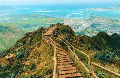
Going on a hike up the infamous Stairway to Heaven Hawaii on the island of Oahu calls for in-depth preparation on your part. It is one of the most dangerous hiking trails. It is also known as the Haiku Stairs.
In this article, you will find information on the hike’s history, current status, alternate routes, incline, security, distance, best weather conditions, helpful gear, and a guide to get there.
History Of The Stairway To Heaven Hawaii
lifeonearth.com
In 1942, contractors for the U.S. Navy began the construction of the Haiku Radio Station. It was a top-secret facility that transmitted radio signals to Navy ships that were operating in the Pacific. To get the right altitude for the antennae, they stretched them across the haiku valley, which is like a natural amphitheater. You might still see the remnants of the wooden ladder beside the new metal steps.
The radio station was commissioned in 1943. A stronger transmitter that could relay powerful signals was necessary. This could not be done with the vacuum tube technology used at the time. So they chose to go with an Alexanderson alternator, which uses a huge device that can generate powerful yet low-frequency radio signals. It would need a large antenna.
When the Naval Air Station Kaneohe Bay was transferred to the Marine Corps around the 1950s, the U.S. Coast Guard used the Haiku Radio Station site for an Omega Navigation System station. In the mid-1950s, the wooden stairs were replaced by sections of metal steps and ramps. The total number of stairs stood at 3,922. The Coast Guard did not stop hikers in the 1970s but had to stop after it featured in the Magnum P.I. movies, which increased the number of visitors. The station as well as the trail have both been closed to the public since 1987.
Recent History
In 2003, plans were made to reopen the stairs to the public, and the cost incurred to repair the stairs was $87,500. The public access being shut down, residents found themselves surrounded by unknown faces of hikers and tourists and litter all around. In early 2018, the City and County of Honolulu released a statement to not open the stairs to the public, showing liability concerns. Some hikers, however, continued to trespass, which only strengthened the local community’s resolve to keep the structure closed to the public.
The Friends of Haiku Stairs, a volunteer group that aims to preserve the trail, pitched that there could be an alternative to a no-trespass, safe public access to the trail without taxpayer costs. The trail now is a disputed one with all its beauty and thrill. However, it has not stopped the locals, hikers, and travelers from stealing past the guards posted at the bottom of the stairs. This hike is a strong dose of adventure, climbing nearly 4,000 steps along an 18-inch wide staircase to reach an elevation of more than 2,000 ft.
Incidents
squarespace-cdn.com
The hiking trail is not a site for any major injuries or accidental Stairway to Heaven Hawaii deaths on the stairs. There have only been minor incidences in the last decade. However, between 2021 and 2022, there have been more number of injuries and rescues of hikers trying to get to the top of the stairs. The rescues have mostly taken place for hikers going through the Moanalua Ridge, which is the longer and more difficult of the trails. Many hikers are rescued “near the Haiku Stairs” and not the Hawaii Stairway to Heaven itself.
In 2014, 6 people were arrested, and 135 were quoted to have climbed the stairs. According to the City Prosecutor's Office, a criminal trespass in the second degree carries a $1000 fine.
The Stairway To Heaven Hike Hawaii: My Experience
The Stairway To Heaven hike on Oahu, Hawaii, is possibly the biggest attraction on the entire island. A grueling number of 3,922 stairs go up to the imposing mountain ridge. Most of the time, the incline is vertical, with only a handrail to save you from falling into the valley below. It sounds dramatic, but it is what it is. But it isn’t too dangerous if you are prepared for it.
Distance: 2 miles or 3 km round trip
Elevation Gain: 2,630 feet or 800m
Duration: 2-3 hrs up, 1-2 hrs down
We started out by being dropped off in the neighborhood at 2 am in the morning. It was a clear night with just a few light clouds hovering over the mountains. As soon as we got out of our car, a resident came rushing out of his front yard, yelling at us. Thus, startled by the old man, we hurried away to the “main entrance” to get our eyes fried with a beaming flashlight.
The Trail
We silently went off in the opposite direction toward an alternate entry point, keeping in mind that the old man quite possibly called the guard or the police to warn them about us. We were thrilled by the idea of being caught and afraid of being caught, actually.
Walking through the neighborhood as quietly as possible, the barking of dogs totally blew our cover, making our presence known. We ran down the street to a small alley that led up to the hill. We had to cross over the barbed wire fence, which was close to a residential area. It is understandable why the residents are so annoyed with trespassers.
From here, we had to steal past the knee-high undergrowth as quietly as we could go. We were nervous when approaching the guard, understanding that we had trespassed multiple sites that were strictly no-go. As we approached the red car of the guard, we found that no guard was around. We walked past it and towards the stairs. As we ascended the stairs, we finally felt relieved to think that the police or guards didn’t go after the trespassers on the stairs.
On The Stairs
change.org
We felt much safer, and we could now enjoy our 3 a.m. hike along the Stairway to Heaven. In 2015, a storm damaged many parts of the stairs to the point where they could not support use. It is not dangerous per se, but it makes your ascension more thrilling. A few of the steps were loose, and we had to keep that in mind while treading on each of them.
We did not have headlamps. We followed the full moon up the narrow and damp stairway. I managed to keep looking back to see the highway, which kept getting smaller as we went higher in order to reach platform one.
Grasping the slippery railing tightly, we made our way to the second platform, where an abandoned cabin lay with old machinery inside. It looked straight out of a post-apocalyptic movie. Another two hours went by, and we almost reached the summit. The final section of the hike consists of boards instead of stairs, which make it a catwalk at 2000 ft. in the air on top of a sharp ridge.
At The Top
squarespace-cdn.com
At the summit, we found an old cabin with huge antennae on top. We moved around the space on top among the clouds. We then returned to the bunker to wait for the spectacular sunset this place always has. Putting on a fresh pair of dry shirts and jackets made the experience much more comfortable while at the summit.
The sky became a pale blue and then shades of purple. With that, the sun came tearing through the haze. It shone yellow and gold over the Haiku Hawaii Valley. Many others witnessed the sunrise along with us, who began their descent once the spectacle of the sunrise was over. One of the trails downward is the Moanalua trial, which is a 6-mile route, but you can miss out on the views. It also helps you avoid the guards if that is your main issue, but it is 3 to 4 times longer than other routes.
The hike down was a treat for photographers. We were in no rush, so we got down at our own pace, taking in the views and shots for our socials. It feels amazing to have ascended in the dark and then descending in broad daylight. It took less than 2 hours to reach the bottom. We saw the guard’s red car where it was in the morning, but this time, we took the risk and did not avoid it.
The Guard Below
.journeyera.com
Meeting guard, he joked, saying, “I’ve called the cops, they must not have come,” as he began laughing to himself. His sense of humor eased our anxiety. He gave us the look of get-out-of-here-before-you-get-caught, and we crept away on queue.
The situation has become much more serious in the recent past, so the guards may not be as friendly as they were. Be careful if you go in 2023.
At the final gate, we saw no signs of police or angry residents. We were free! We could not believe we had just hiked the Stairway to Heaven Hawaii! This is truly a place for one and all. It looks like the real version of Jurassic Park. It is dreamy as well as eerie. You can totally attempt this hike if you visit Oahu.
Try to have someone who has visited before guide you through this hike if you visit here for the first time.
Alternate Route
thatadventurelife.com
The alternate route is the Moanalua Trail. The route is 9.3 miles in length. It gets you all muddy and is not the easier option, either. It can help you avoid the guards at the beginning of the trail. But it is not hassle-free. It all depends on when you go and how well-prepared you are for any kind of situation.
Things To Pack For The Stairway To Heaven Oahu Hawaii Hike
Going unprepared for the hike is one of the biggest mistakes you will make. You must have the basics and stay prepared for bad weather. Here is a list of essentials you must consider among everything else.
Arcteryx BETA AR Rain Jacket: This is the rain jacket of your dreams. They are super light. They will fold into the tiniest ball and save you from the harshest storm.
Salomon X Ultra 3 Mid GTX Hiking Boots: For better ankle support on that 400-step long hike, waterproofing and toughened exterior are necessary for your boots. These Solomons can easily be your best buddy.
Black Diamond Head Torch: In case you return incredibly late from your hike and it gets dark, a headlamp will help you as nothing else will. Keep this one handy for sure.
Darn Tough Socks: These will be the most comfortable hiking socks you will own. They don’t wear out easily, either. They have a lifetime warranty. You simply send them with any sign of wear and tear, and they will replace it without further questions.
Frequently Asked Questions (FAQs):
Here are some common questions people ask about this hike, take a peek:
1. How Did The Stairway Come About? The stairs were originally built in 1942 by the U.S. Navy as a top-secret facility to transmit radio signals to ships that were sailing in the Pacific Ocean. The stairs went public, deeming it fit until 1987, when it became dangerous due to disrepair. Residents of Oahu have fond memories of hiking up the stairway to heaven legally a long time ago.The city of Honolulu reportedly spent almost a million dollars in renovating the stairs and considered re-opening the stairs to the public in 2002. Resident complaints and safety concerns halted the re-opening, and the stairs have stayed closed ever since. 2. What Are Some Of The Other Places To Visit In Oahu? You could take a helicopter flight tour without the doors. The view from above will blow you away. A shark cage tour can ensure you don’t talk about thrilling adventures for another year or so. It will give the adrenaline rush like no other. Ecofriendly dolphin and snorkel tours are also available.
Wrapping Up
The Stairway to Heaven Hawaii trail is dangerous when seen from below. It is only when you undertake the hike (with proper planning and preparedness, of course) that you understand it is not as daunting as it looked. All you need is a thirst for thrill and sharp wit that comes in handy when you go face to face with adversity. There is also the added fear of strict laws around the hike, which will keep you on your toes.
Let us know if you visit this amazing trail. And if you have questions or thoughts to share, please leave a comment below. We would love to hear from you!
Read Also:
Portals To The Unknown: Exploring Natural Gravity Vortex!
The Perfect Getaway: Discovering The Closest Beach To Disney World!
Walking On Sunshine: Exploring The Magic Of Vietnam’s Golden Hand Bridge!


 Related