Pamukkale is one of the most visited regions in Turkey in 2025. With its natural beauty and historical intrigue, it welcomed 1.6 million visitors in 2025, according to a recent Travel and Tour World report.
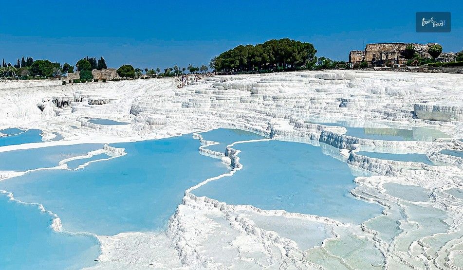
Home to the Hierapolis spa city, Pamukkale Turkey, has snow-white travertine terraces, which look dramatic against the backdrop of blue skies. Also, it is one of the most prominent destinations in Turkey to promote nature-based tourism.
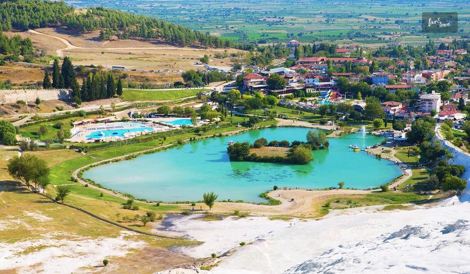
Also, resembling a winter wonderland covered with snow, Pamukkale is actually a unique landscape formed by hot spring waters in a Sun-kissed zone of Turkey.
Where Is Pamukkale Turkey?
Pamukkale is in the Denizli Province of southwestern Turkey. It has Hierapolis, a UNESCO World Heritage Site and a unique landscape, including white travertine terraces. The unique landscape is built with the carbonite mineral deposits of the hot water springs here.
Furthermore, Pamukkale is in the Inner Aegean region of Turkey and it is in the valley of the River Menderes.
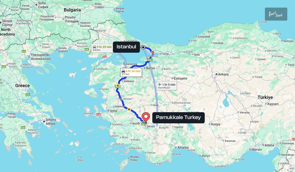
How To Reach Pamukkale Turkey From Istanbul?
The distance between Pamukkale and Istanbul is close to 572 km, and based on your mode of transport, it will take between 6 hours 20 minutes and 11 hours to reach Pamukkale.
1. Istanbul To Pamukkale Turkey By Train
You can take a train from Istanbul to Eskişehir and then board the Pamukkale Express from Eskişehir to Denizli, where Pamukkale is located. This 8-hour journey by train allows you to cherish the beauty of central Anatolia.
Otherwise, board a train from Istanbul to Yenikapı and then a train to Pamukkale. The train will pass through stations such as Istanbul Pendik, Eskişehir, and Goncalı.
2. Istanbul To Pamukkale By Air
The Denizli-Çardak Airport (DNZ) is the nearest airport to Pamukkale. It is located at a distance of 67 km. You can take a domestic flight from Istanbul to Pamukkale and then take a shuttle or a bus to reach Pamukkale by road within 50 minutes.
3. Istanbul To Pamukkale By Road
Companies such as Kamil Koç operate direct buses from Istanbul to Sarayköy. From Sarayköy to Pamukkale, it is a journey of less than 30 minutes by road.
Moreover, you can take overnight buses to Pamukkale from Istanbul.
What Is So Special About Pamukkale Turkey?
With thermal springs, white hills of cascading water, and crystal lakes, the unique landscape of Pamukkale looks stunning. Furthermore, it has Hierapolis or the “Holy City.”
Fortunately, all these unique features of Pamukkale are mostly intact even today. Moreover, as the UNESCO World Heritage Convention says, it is a wonderful fusion of natural beauty and cultural richness.
“The property is largely intact and includes all the attributes necessary to express its Outstanding Universal Value, based on the strong and tight integration between the natural landscape (the white travertine terraces and numerous thermal springs) and culture (the city ruins from the Greco-Roman and Byzantine period, especially the theatre and the necropolis). The boundaries of the site are adequate to reflect the site’s significance.”
– UNESCO World Heritage Convention.
Let’s explore its unique features and landmarks.
1. Cotton Castle Pamukkale Turkey
Pamukkale means cotton castle in Turkey, and the name comes from the travertine terraces, which have white formations with a cotton-like appearance. The terraces here form stepped pools, and together they look like a cascading castle of white cotton and crystals.
But do you know how this unique landmark was formed? Western Anatolia in Turkey has the largest deposits of calcium carbonate rocks in the world. However, it is also the region where the Earth’s crust faces the maximum pull.
Furthermore, various geothermal, seismic, and volcanic activities here create many fissures and faults. The Pamukkale plateau in the Denizli Basin is one of the main examples of this kind of geological formation.
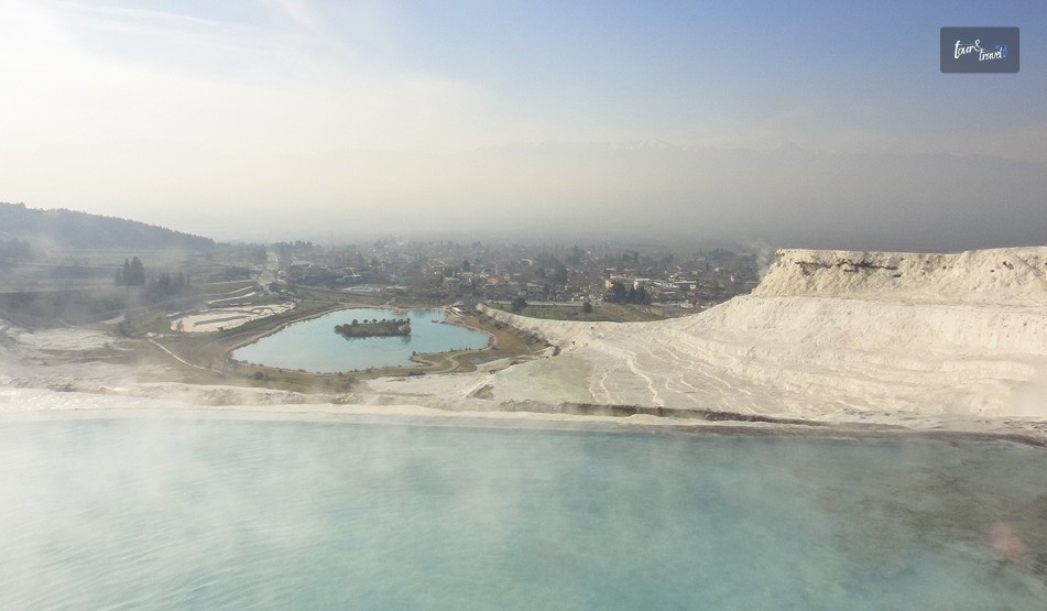
Here, the calcite terraces and rimstone pools fall from over a 200-meter-tall cliff. Being rich in minerals, the cascading water covers the rocks with a thick layer of white sediments. These rocks look like layers of cotton and have thus got the name Cotton Castle.
According to NASA, the mineral deposition in this area is aged between 50000 and 600,000 years. The process started from the Pleistocene epoch, and the latest deposition here is related to the Laodikeia earthquake.
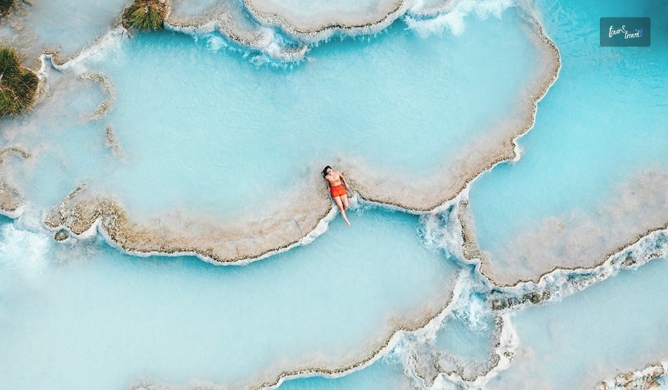
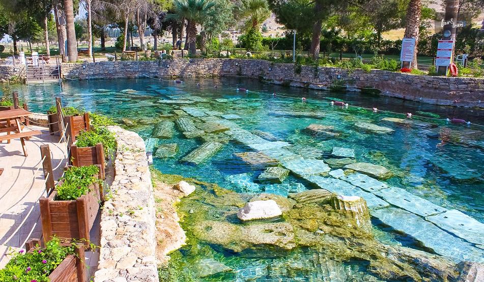
2. The Pools Of Pamukkale Turkey
The thermal pools in the travertine terraces of Pamukkale were formed with mineral-rich hot spring water falling down the hillside and solidifying the deposits.
The vast Cleopatra’s Pool is probably the most prominent example when we talk about the pools of Pamukkale. The average water temperature of these pools ranges between 19 and 57 degrees Celsius. Sometimes the temperature can be as much as 100 degrees Celsius.
3. The Hot Springs Of Pamukkale
The hot springs of Pamukkale have geothermal water, which is rich in minerals. Being mineral-rich, these waters have many therapeutic benefits.
Moreover, it is a lifetime experience to swim in the geothermal pools on travertine terraces against the beautiful white walls.
4. The Ancient Hierapolis Or The Holy City Of Pamukkale
King Antiochus II founded ancient Hierapolis in the 2nd century BCE at the top of Pamukkale. Its strategic position near the thermal rings and along the trade route made it a thriving city during the Roman Rule.
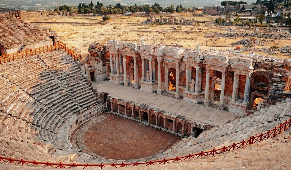
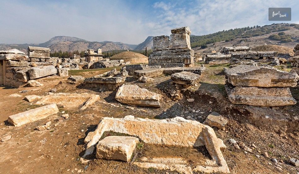
Furthermore, Hierapolis became a prominent spa and healing city, and it grew in religious and cultural significance over time. The vast necropolis, the Temple of Apollo, and the Roman theater are the telltale signs of a rich history of Hierapolis, or the Holy City of Pamukkale.
Moreover, during the Byzantine era, Hierapolis experienced tremendous growth as a Christian hub, and it became a bishopric. In addition, the necropolis area saw many churches being built, and it became a chosen resting place for Christian martyrs.
Finally, in 1988, UNESCO gave the combination of Hierapolis and Pamukkale the designation of a UNESCO World Heritage Site.
Pluto’s Gate was believed to be the gate to hell or the underworld. This prominent archaeological site was associated with Pluto, the Roman God of the dead, wealth, and the underworld.
The scientific explanation behind this place is that geothermal activities in Pamukkale caused the release of a large amount of carbon dioxide. Thus, it became a lethal area, and the priests utilized this natural phenomenon to convince pilgrims of the place’s mystical power.
What Are The Things To Do In Pamukkale Turkey?
As I have already mentioned, the things to do in Pamukkale are the perfect fusions of natural, cultural, and religious explorations. Try these activities here.
1. Taking A Bath In Cleopatra’s Pool
Cleopatra’s Pool got its name from Queen Cleopatra taking a bath in this pool. It is surrounded by marble columns that go back 1000 years.
This pool is just a 10-minute walk away from the main ruins of Hierapolis.
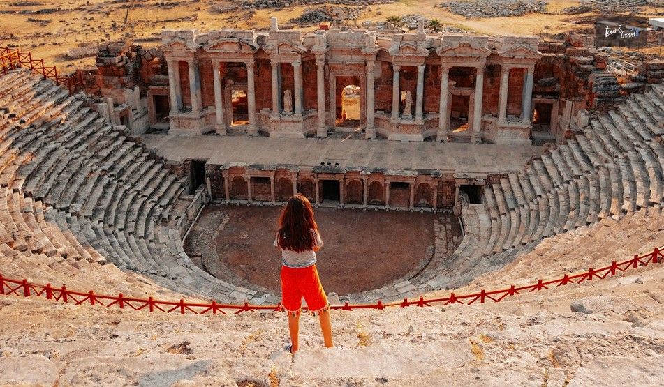
2. Exploring The Roman Theater
The history of the Roman Theater goes back to the 2nd century AD. It could accommodate 12,000 visitors and was the venue for theatrical performances and gladiatorial battles.
Even today, the Roman Theater is well-maintained, and you can enjoy a panoramic view of Pamukkale from this place.
3. Taking A Stroll Around The Necropolis
The necropolis area of Pamukkale has tombs and family mausoleums that belong to the Byzantine, Roman, and Hellenistic periods.
The necropolis area is like an outdoor museum where you can read the plaques and learn a lot about the people who stayed here and how they viewed life and the afterlife.
4. Visiting The Local Villages
The Pamukkale Village offers you a slice of the ultimate Turkish rural life. Try the mezes or appetizers, kebabs, and Pide or Turkish pizzas from local shops and restaurants here.
Also, you can explore the shops here to buy ceramic items, jewelry, and textiles.
5. Enjoying A Walk Through The Travertine Terraces
Take a walk along the travertine terraces and experience the wonder of nature at its best. Furthermore, you can wet your feet in the warm waters of the pools here.
However, you have to walk carefully on the surface as it can be slippery.
Here are the frequently asked questions and answers about Pamukkale Turkey.
1. What Is The Best Time To Visit Pamukkale Turkey?
April to June, or the spring season, and September to November, or the autumn season, are ideal times for a visit to Pamukkale. However, if you want to avoid the crowd, the winter months of December to March are the best options.
2. Which City Is The Closest To Pamukkale Turkey?
Denizli is the closest city to Pamukkale. The distance between these two places is around 17 km. Today, Denizli City is a bustling hub of textile production and export.
3. Is It Possible To Swim In Pamukkale?
Yes, swimming is allowed in the travertine pools in Pamukkale. However, there are only some designated pools, such as the Cleopatra Pool, where you can swim.
4. Is 1 Day Enough In Pamukkale?
Yes, one day is enough to explore the Pamukkale. You can take a bath in the travertine pools, explore the ancient ruins, and visit the local villages within 5-6 hours.
5. Which One Is Better? Cappadocia Or Pamukkale?
Cappadocia and Pamukkale both have stunning landscapes. However, Cappadocia is famous for adventurous activities, like hot air balloon rides. On the other hand, Pamukkale is a place for natural exploration, visiting the ancient ruins, and taking a bath in the travertine pools.
6. What Language Is Spoken In Pamukkale?
Turkish, the official language of Turkey, is the main language in Pamukkale. However, people here also speak in English.
7. Is Pamukkale Good For Skin?
Yes, Pamukkale is good for the skin. The presence of silica, sulfur, and calcium in the water improves the elasticity of the skin, cleanses the skin, and alleviates eczema and other skin conditions.
8. Can I Drink Water In Pamukkale?
The water of the thermal springs and pools of Pamukkale is rich in minerals. So, it is better to avoid drinking the water from the hot springs and pools in Pamukkale.
9. Do I Need To Pay Entry Fee To Visit Pamukkale
Yes, you will need to pay an entry fee to visit Pamukkale. Furthermore, there will be an additional fee if you want to swim in the Cleopatra Pool.
Sibashree is a travel, culture, and leisure writer who has been writing since the age of 12 and professionally since 2014. With more than a decade of travel writing experience and journeys across India and several parts of the world, she brings a deeply personal and thoughtful perspective to her work. A student of English Literature and Mass Communication, Sibashree has always viewed travel as more than movement — for her, it has been a way of understanding people, cultures, and herself. Her passion for spiritual exploration has also led her to many unusual and meaningful destinations over the years. Outside of writing, Sibashree enjoys watching European cinema, reading about global politics, and reflecting on the stories hidden within everyday places.
Spring is the perfect time to embark on a journey with your loved ones to explore new and exciting summer destinations that cater to your preferences and needs. While traveling can be an exciting and enriching experience, it is important to take proper care of your eyes to ensure a stress-free trip.
Your eyes may be exposed to a variety of stressors, including different environments, climates, and long flights, which can affect your vision and ruin your vacation.
To ensure that you have an enjoyable trip without worrying about your eye health, read below!
Tips To Take Care Of Your Eyes During Vacation!
We have got the best tips for you in order to have a healthy vision on your trips and have the best time of your life!
Pre-trip eye exam
Prior to traveling, it's important to schedule an appointment with an ophthalmologist. They can examine your eye health and provide recommendations on how to protect your eyes from any potential risks you may encounter while traveling. They can also ensure that your glasses or contact lenses prescription is up-to-date to avoid any discomfort or vision issues during your trip. So, add to your calendar this appointment with your optician and you are not going to regret it at all.
Polarized sunglasses
Moreover, sunglasses are a must-have accessory for anyone traveling to sunny destinations. However, not all sunglasses provide the same level of protection. It's important to invest in polarized sunglasses that are designed to block harmful UV rays. Polarized sunglasses are known to reduce glare as well as improve the clarity of vision. This makes them an excellent choice for anyone who loves outdoor activities.
Rest your eyes
Of course, long flights or road trips can be exhausting, and staring at a screen or reading a book for an extended period of time can cause eye strain and headaches. To prevent this, take a break every hour or so and close your eyes or look at something in the distance. This will give your eyes a chance to rest and reduce the risk of developing eye strain.
Stay hydrated
As you might already know about eye health, the fact is that dehydration can cause dry eyes, and being on a long flight or train ride can exacerbate this issue. To prevent this, make sure to drink plenty of water throughout your trip. Drinking enough water can also help to reduce the risk of developing eye infections, especially if you wear contact lenses.
Eye drops
Last but not least, dry eyes can also be caused by environmental factors, such as air conditioning, heating, or pollution. In these situations, artificial tears or lubricating eye drops can help to keep your eyes moist and comfortable. It's important to pack these drops in your carry-on luggage, especially if you're traveling to a dry or polluted area. This way you will not feel your eyes to be itchy or hurting, you will feel ready to embark on this new adventure!
Keep Contact Lenses Handy
It is very important that you are able to take care of your prescribed contact lenses if you have any, when you are on your trip. Ensure that you are taking them off in regular intervals and keeping them in the safe and prescribed space with the solution. While it is true that you may not get everything at hand all the time, ensure that you are carrying the lens solution with you all the time. Avoid using other substitutes like water in this case.
Carry extra pair
It is important that you are carrying an extra pair of eye care all the time when you are on your trip. Have you ever considered what might happen if you lose your prescription medicine or your medicated sunglasses when you are on vacation? Well, if that is something that you want to avoid it is important that you always carry an extra set of lenses, glasses, and your eye medicines with you.
Avoid or use minimal eye-makeup
Last but not least on this list is the fact that it is important you are not using a lot of eye makeup when you are on your trip. These things attract and trap or retain a lot of dust and dirt. This might make it difficult for you to have an enjoyable trip at the end of the day. It is also best to avoid using too much eye makeup as this may cause a risk of an eye infection.
Bottom Line
If you found the answer that you were searching for I hope that this article has been of help to you. If there are any other queries related to the same, feel free to let me know.
All that you need to do is scroll down till you reach the end of this article and drop your doubts and queries in the comment box below. And I will be there to answer them all for you!
Read Also:
Hopper Flights Review- Login, Services, And Travel Experiences
Myenvoyair Review – Registration, Login And Benefits In 2023
Using Google Flights To Find Cheap Flights In 2023? All That You Need To Know!
As the winter season comes to an end, it's an excellent opportunity to plan a trip to a spectacular destination around the world. Europe offers a diverse selection of breathtaking locations for the spring season, catering to every preference and taste. If you're looking to travel in beautiful European towns, the most efficient mode of transportation is by bus. It not only saves time, but it also allows you to see more of the beauty Europe has to offer.
However, organizing a bus tour in Europe can be a daunting task for an event planner. You must take into account various factors, such as selecting the right destinations and ensuring the safety and comfort of your passengers. Yet, with meticulous planning and keen attention to detail, you can orchestrate an enjoyable and unforgettable bus tour experience for everyone involved.
For those interested in preparing an enjoyable bus tour in Europe, continue reading as we explore some of the best tips.
So, do you want to know more about the tips for making your European bus journey special in detail? This guide can be of help. Further, I will share brief accounts of the bus tours you will enjoy the most.
Let the fun begin!
THESE Are The Things You Need To Follow To Make Your Bus Tour In Europe More Enjoyable
If you assess the Tourist Bus Market in the world, you will find Europe to be one of the key players in the market. To be more specific, market data shows that Europe has the second-largest Tourist Bus Market globally. It is just behind North America.
This market data shows that tourists prefer exploring the continent in buses. Furthermore, the Tourist Bus Market of the UK is the fastest growing in the entire bus tourism scenario of Europe.
However, despite the favorable scenario of a bus tour in Europe, you need to keep the following tips in mind to make the experience more enjoyable.
One of the best ways to plan an enjoyable bus tour in Europe is to get an Europe bus tour operator. An experienced tour operator can provide valuable insights into the best destinations, routes, and transportation options. They can also help you plan activities, accommodations, and dining options that are tailored to your group's interests and budget. Additionally, they can assist you in securing permits, visas, and insurance, which can be overwhelming for first-time organizers.
1. Determine The Interests Of Your Group
Before you start planning your itinerary, it's essential to determine the interests of your group. Are they history buffs, nature lovers, or foodies? Knowing your group's interests will help you plan activities and attractions that they will enjoy. For example, if your group is interested in history, you might want to include visits to some of the best museums in Europe and historical landmarks. If they are nature lovers, consider including a hike or a visit to a national park. If they are foodies, include visits to local markets, food festivals, and restaurants that offer a variety of cuisines.
2. Allocate Time Effectively
When planning your itinerary, it's important to allocate time effectively. Don't try to cram too many activities into a short period. Allow enough time for your group to explore at their own pace and have some free time to relax. Be mindful of the time of day and avoid scheduling activities during rush hour. Remember that not everyone in your group will have the same level of energy, so plan activities that are suitable for all ages and fitness levels.
3. Prioritize Comfort And Safety To Enjoy Your Bus Tour In Europe
Last but not least, comfort and safety should be a top priority when planning a bus tour in Europe. Choose a reliable and comfortable bus company that can provide you with good accommodation when it comes to your group's size. They should also be able to ensure an enjoyable and safe ride. Make sure the bus is equipped with air conditioning, comfortable seats, and a restroom. Consider booking accommodations that are centrally located, easily accessible, and offer amenities like free Wi-Fi and breakfast. Ensure that your group is aware of safety protocols and emergency procedures, and provide them with the necessary contact information in case of an emergency.
4. Get An Experienced Tour Operator
An experienced tour operator can provide valuable insights into the best destinations, routes, and transportation options.
They can also help you plan activities, accommodations, and dining options that are tailored to your group’s interests and budget.
Additionally, they can assist you in securing permits, visas, and insurance, which can be overwhelming for first-time organizers.
Bus Tour In Europe: Places To Visit!
1. Florence And Pisa Bus Tour In Europe
Pocket Pinch: 25-40€
The Florence and Pisa bus tour is one of the best in Italy, and this is a great opportunity to see one of the seven wonders of the world on a budget.
You will find multiple bus tourism packages, and they often include a visit to the Piazza dei Miracoli, a UNESCO World Heritage Site. Other important places included in these tours are Siena, Tuscany, and San Gimignano.
Moreover, you can include a delightful wine and food tour in your plan to visit Florence and Pisa on a bus tour.
2. Barcelona Bus Tour
Pocket Pinch: 36€ For Adults And 15€ For Kids
Barcelona Bus Turistic and other tourist bus services in Barcelona make exploring this intercultural city delightful. Especially, with Barcelona Bus Turistic, you can enjoy a ride in an open-top double-decker bus.
Further, you can ask if the bus service has a day pass or not. The places of attractions on this tour are Park Güell, Passeig de Gràcia, Barcelona’s Stadium, etc.
3. Tour Of The Famous Grindelwald
Pocket Pinch - 235-310 Swiss Franc
Grindelwald Bus and other tourist bus services offer you a comfortable detour to the famous Grindelwald. The bus network here covers the local and mountain lines.
The highlights of the tour are First Cliff Walk, Glacier Canyon, Mount First, etc.
4. Terceira Island
Pocket Pinch: Around 42€
A half-day bus tour in Terceira Island, Portugal, is enough to discover the best viewpoints, including Serra do Cume, here.
Further, you will love the pristine white beach of Praia da Vitória.
5. The Ruins Of The Ancient City Of Pompeii
Pocket Pinch: 95€
Pompeii is a UNESCO World Heritage Site and this ancient city was engulfed by ash with the eruption of Mount Vesuvius in 79 AD. 1748 and 1763 were two important years in the history of Pompeii, with Spanish engineering discovering the site and an inscription being found about the name.
Today, the remains of Pompeii stand as the telltale of the best days of Imperial Rome.
More Bus Tours In Europe
The options for bus tours are endless in Europe. You can even visit the following places by booking a tourist bus pass or ticket.
Lake Myvatn
Stockholm Castle And Gripsholm Castle
Ireland
Britain
France
Switzerland
Spain
Italy
Balkan Valley
For a traveler in Europe, bus services are one of the best modes of communication. Along with booking a tourist bus, you can also take an intercity bus service to visit one state from another.
Eurolines, National Express, OUIBUS, etc., have the largest intercity bus networks in Europe.
If you're planning to take a long-haul flight, you may be wondering how to keep yourself entertained during the journey.
Whether you're traveling solo or with companions, it can be tough to pass the time, especially if you struggle to sleep while in transit. But nothing to be worried about we've got you covered! We've compiled a list of 15 fun and engaging activities that can make your long-haul flight seem like a breeze.
From downloading movies in advance to bringing along cool products, these ideas are sure to keep you entertained and engaged throughout the journey. So, read on to discover our top picks for things to do on a long-haul flight, regardless of your age or interests.
Plan About Your Upcoming Trip
If you've had a busy schedule leading up to your flight, or if you've booked a last-minute trip without much research on the destination, don't worry! Your flight can be the perfect opportunity to plan out your ideal holiday.
We suggest doing some online research a few days before you Book Flight Tickets from Canada to India and making a list of all the places you want to visit, as well as saving them on Google Maps for easy access. You can create a detailed itinerary by deciding about the days on which you can visit certain attractions and grouping together places that are nearby while you are on the flight.
In some cases, long-haul flights may offer Wi-Fi, which means you can browse the internet for inspiration and ideas. We highly recommend checking out Flyopedia for recommendations and reviews. Once you have a general plan in mind, make sure to jot everything down in a journal or on your electronic device, so you won't forget anything important.
Binge on In-Flight Entertainment
One of the most obvious yet enjoyable activities to do on a long-haul flight is to indulge in in-flight entertainment. Regardless of the airline, long-haul flights usually offer a great selection of movies, including some that haven't been released for home entertainment yet.
So, sit back, relax, and catch up on the latest and greatest movies! Be sure to check the website of your airline when you Book Cheap Flight Tickets from Canada to India to see what dates are available during your travel.
In case your flight does not have features like screens for personal entertainment, or if you're unsure, you can always bring along your phone, laptop, or tablet and download your favorite TV shows and movies before the flight. Each movie can easily take up a couple of hours of your flight time, giving you plenty to watch throughout the journey.
Clean Up Space in your Phone
One of the best ways to utilize your time on a long-haul flight is to get your cell phone organized and free up some space while you're at it. Here are a few tips to help you do just that:
Create folders or categories for your apps, such as camera, travel, health, and so on, and move all similar apps into their respective folders.
Delete any apps that you no longer use or need.
Go through your contact list and remove any unnecessary entries or people that you can't remember.
Sort through your photos, deleting any embarrassing selfies or duplicates of photos that look practically identical.
Remove and clean your phone case, if you have one.
By taking these steps, you'll not only free up valuable memory on your phone, but you'll also make it easier to navigate and find what you need when you're on the go.
Play Games
If the inflight entertainment system on your flight has a games section that you should check while looking out for Cheap flights to India from Canada, you may be able to connect and play games with other passengers. However, if that's not an option, don't worry!
You can always enjoy classic games like Solitaire and Sudoku. For those who are more organized, you could even bring along games such as adult coloring books, word searches, and crossword puzzles in paper form or downloaded on your phone or tablet. These activities are not only enjoyable, but they can also help pass the time and keep your mind engaged during the flight.
Tune in to Audio Books
Listening to audiobooks is a wonderful way to pass the time during long flights, and it's a hobby that's becoming more and more popular with each passing day. In fact, some people even use audiobooks to learn a new language!
With a wide range of genres available, you're sure to find a book that suits your interests, from fantasy novels to autobiographies to historical fiction. Plus, audiobooks can help make the time fly by, as they can average around 11 hours in length.
Write Down A Journal
Keeping a journal can be an incredibly versatile and valuable tool for personal expression. Whether you aim to document your emotions in the present moment or engage in creative writing exercises, the possibilities of journaling are endless.
The act of journaling empowers you to explore your thoughts and feelings in unique ways, from outlining your aspirations and ambitions to mapping out your itinerary for an upcoming journey. You may even choose to create a personalized ranking system or simply sketch out some random ideas and images.
Ultimately, the beauty of journaling is that it's a flexible and adaptable practice that can help you unleash your creativity, clarify your goals, and cultivate a deeper sense of self-awareness. So why don’t you give it a try and see where this journey takes you?
Learn A New Language
When traveling to a foreign country where the language is unfamiliar, having a basic understanding of key phrases can prove invaluable. Simple expressions like asking for directions, inquiring about prices, and politely asking if someone speaks English can make a big difference in your travel experience.
To make the most out of your trip, it's a great idea to invest time in learning essential travel vocabulary and phrases. You can easily access language-learning resources online or download language apps before you depart.
These resources can provide you with a wealth of useful expressions and dialogues that you can study while on your flight. Not only is this a productive way to pass the time, but it also allows you to deepen your understanding of the language and culture you are exploring.


 Related