Related
Dark Tourism in India Exploring Shadows and Must-Visit Sites
BY Sibashree Sep 30, 2024
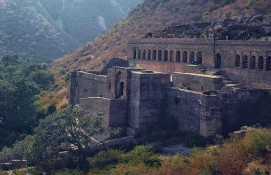
India is leading the dark tourism scenario With an expected CAGR of 5.1% (2024-2034),. Dark tourism in India thrives as it is the land of history and heritage. Also, travel a few miles, and you will get to know folklore or common myths related to paranormal activities. So, dark tourism in India takes you to places associated with human tragedy or something that raises our curiosity. Endless warfare and the rule of various dynasties have drenched its soil in blood from time immemorial. Further, superstitions and oppressive customs in various parts of the country have caused human casualties that can give you a chill down your spine. However, dark tourism in India or any part of the world is not just about people’s fascination with the macabre or its inclination to encounter the grey zone. Many dark tourism sites like the Cellular Jail in the Andaman and Nicobar Islands or Jallianwala Bagh tell the tales of a collective past. So, these are often popular destinations for educational tourism or excursions. With endless stories and mysteries spread in every corner, India will spoil you with the choices of dark tourism spots. Here is a list of places you just can’t miss! Dark Tourism In India: These Are The Places You Need To Visit For me, dark tourism in India is like communicating with the past. These places and the remnants there convey a message that can trigger our moral emotions such as empathy, gratitude, disgust, or sadness. Further, these moral emotions can change our perspective about ourselves, various communities, and society. Moreover, curiosity is present in people’s love for the occult. Some categories of dark tourism, such as ghost tourism, thana tourism, and disaster tourism, especially urge many to get into the shadows. We absolutely agree with Karan Anand, the Head of Relationships at Cox & Kings. So, which places does dark tourism in India take us to? Here is a curated list! 1. Port Blair Cellular Jail | Kala Pani | The Prison Of Death Location: Andaman and Nicobar Islands One of the most prominent witnesses of British atrocities in the country, the Port Blair Cellular Jail tops almost all the lists of dark tourism in India. The British government made a hell of concrete in 1906 in the form of a prison, and it was almost impossible to escape or come out of it. Vinayak Damodar Savarkar, a freedom fighter in India, was the only person who had escaped the Port Blair Cellular Jail. The British Raj sent convicts with the highest punishment to this jail. Once, this jail housed as many as 80000 prisoners, and among them, at least a few hundred were the freedom fighters. The freedom fighters received the “Kalapani ki Saza” to lead a life of isolation. Constructed in the shape of a starfish, the Port Blair Cellular Jail is witness to inhuman tortures and genocides. Along with the atrocities of the British Raj, it has also seen the genocides operated by the Japanese. When at the Cellular Jail, don’t forget to attend the “Light & Sound” show in the evening. It is like time travel, giving you goosebumps. 2. Jallianwala Bagh Location: Amritsar City, Punjab The 13th of April 1919 saw one of the worst examples of British acts of barbarity in India. Innocent people had gathered at Jallianwala Bagh in Amritsar City to peacefully protest against British rule. Jalianwala Bagh was blocked from all sides, and Brigadier-General Dyer ordered his men to open fire at these innocent and unarmed people. The 1650 rounds of firing continued for 10-15 minutes, taking the lives of more than 500 people. Today, when you visit Jallianwala Bagh, you can see many bullet holes struck in the structures there. In 1951, a memorial was built here to pay respect to the Indian revolutionaries. Further, in 2019, the inauguration of the Yaad-e-Jallian Museum took place. The museum depicts the most authentic account of the massacre. A century later, in 2019, an official acknowledgment of “regret” came from British Prime Minister Theresa May on the Jalianwala Bagh massacre. This substantiates how grave and gruesome the act of mass killing was. 3. Roopkund Lake Location: Uttarakhand Located at a 5000-meter altitude, Roopkund Lake is one of the most popular trekking destinations in Uttarakhand, India. However, you can see hundreds of human skeletons near the lake, named the “Lake of Skull.” Researchers have found that around 200 pilgrims died of heavy snowfall in the place in the 9th century. So, there are so many skeletons around the lake. Roopkund Lake is also known as the “Mystery Lake,” and there are stories about the pilgrims getting turned into stones or the Goddess getting angry. However, Veena Mushrif-Tripathy, a member of the 2004 investigation and a professor of archaeology at Deccan College in Pune, mentioned that the theory of the pilgrims was reasonable as there were no traces of weapons. 4. Shaniwar Wada Location: Pune, Maharashtra Shaniwar Wada, built in 1732 by Bajirao I, is a historically significant fort and stands out for its architectural excellence. This fort was once the seat of the Maratha Peshwas. This fort became a tourist attraction after the 2015 magnum opus of Sanjay Leela Bhansali, Bajirao Mastani. However, Shaniwar Wada is a favorite dark tourism in India destination because of a popular ghost story or folklore associated with it. Narayanrao, the son of Bajirao I, was killed by his uncle Raghunathrao in 1773 in this fort. Since then, people have experienced paranormal activities in the fort. Many have claimed to have encountered the dead prince. 5. Kuldhara Location: Jaisalmer, Rajasthan How about visiting a village abandoned by its people around 200 years ago? Kuldhara, the cursed village of Jaisalmer, was the residence of the Paliwal Brahmins. They left the village because of water scarcity and the high taxes imposed by Diwan. Another story is about Salim Singh, the local prime minister, who wanted to marry the daughter of the village head. The villagers did not agree to his demands and vacated the place overnight. They also cursed the place, saying that no one could settle there. Further, some even associate the overnight evacuation with paranormal activities. Whatever the reason, many people have tried but failed to spend a night in this village. Today, abandoned houses, temples, and other architecture speak of excellence, craftsmanship, and intrigue. It is also a favorite destination for movie-makers and photographers today. Films like “Agent Vinod” are shot here. Moreover, the village is now a “Protected Monument of the State Archaelogy Department.” 6. Dumas Beach Location: Surat, Gujarat Dumas Beach is one of the most haunted places in Gujarat. With its black sand and paranormal activities, this beach transforms into a hellish spot as the Moon shows up. The beach was earlier a cremation ground. The black color of the sand comes from the ashes of those corpses. While we could not see the moving orbs or any prominent paranormal activity, I felt eerie at the beach. Also, I can’t explain, but there is something very depressing about this beach. It feels like you can hear the whispers of the lost here, and someone will suddenly appear in the shadows. There have been reports of many tourists going missing from Dumas Beach. Also, one day, local people discovered the corpse of a man at the beach. His tongue was popping out. To date, no explanation has been found behind these tragic incidents. 7. Bhangarh Fort In the Aravallis, the Bhangarh fort has the remains of a deserted marketplace, Havelis, and temples. The architectural excellence of the fort is beyond question, and it speaks of a prosperous past. However, Bhangarh Fort is the most haunted place in India. It has stories and myths enough to scare you to bits. Bhangarh Fort Story: 1 The Archaeological Survey of India has banned entering or staying in the Bhangarh Fort after the Sunset. According to the local people, no one entering the fort at night has been able to come out alive. The fort becomes a site of paranormal activities in the darkness. Bhangarh Fort Story: 2 Guru Balu Nath used to meditate at this place. When Raja Madho Singh visited him with a request to build a fort here, he agreed on one condition. He asked the king to promise that the shadow of the fort would not touch him. Despite the king’s promise, it did not happen. Furious, the hermit cursed the castle and the village. Bhangarh Fort Story: 3 No house in the area has a roof. People believe that the roofs of those houses were destroyed due to the curse of the hermit. All attempts to rebuild the roofs went in vain. Many of those roofs also collapsed, causing human casualties. Bhangarh Fort Story: 4 (Accidents And Deaths) Three people once decided to stay in Bhangarh Fort at night. They had a powerful torch, but one group member fell into a well. The two others rescued him and took him to the nearby hospital. However, they met with a fatal accident on the way to the hospital and lost their lives. Do you want to explore more sites that are suitable for dark tourism in India? Visit the Taj Palace Hotel in Mumbai, Union Carbide Factory, Bhopal, Sites Of Indus Valley Civilization, Savoy Hotel, Mussoorie, and Gandhi Smriti, Delhi. Listen to hushed murmurs and the stories these places have to share to make a journey to the past! Also read Top 10 Most Popular Paraguay Food That You Must Try. Top 13 Famous Wonders Of India That You Must Visit! [Updated 2024]