The question appears simple, at least at a glance. But if you think about it, it does open an interesting window into the dynamic world of temperature, rather, how we tend to measure temperature.
Moreover, it also gives insight into why different people use different measurement systems across the globe.
The most fascinating part? How do these systems even relate to extreme temperatures?
The answer might actually surprise you. -40°C and -40°F are exactly equal. Yep! That’s right – it is the point of meeting for the two temperature scales.
On that note, let’s dissect and unpack why this even happens.
More importantly, what else do you need to know about the two temperature scales before you can plan your next mountain escapade.
Celsius Vs Fahrenheit: What’s The Difference?
To make things super easy for you to understand, I have laid out the difference between Celsius and Fahrenheit in simple terms below:
Aspects
Celsius
Fahrenheit
Origin
Anders Celsius, a Swedish astronomer, developed the Celsius scale in 1742.
Daniel Gabriel Fahrenheit, a German physicist, developed the Fahrenheit scale in 1724.
Definition
“of or using a scale of temperature in which water freezes at 0° and boils at 100°.” (Oxford Dictionary)
“of or using a scale of temperature in which water freezes at 32° and boils at 212°.” (Oxford Dictionary)
Used In
Most places in the world, including Europe, Australia, Africa, Asia, and most scientific work.
I already answered this question in the very beginning – both are the same! It is the point at which the two scales meet.
So, if you use the conversation formula I have listed above, then:
-40°C × 9/5 + 32 = -40°F
Also, this is the only point where Fahrenheit and Celsius readings match.
Then, why does it confuse all of us? It is mainly because of three primary reasons, as per my understanding:
Most individuals don’t really encounter extreme weather conditions. So, they do not really come across this overlap point.
Secondly, in most countries, the education system teaches only one scale. As a result, there is little or no intuitive comparison.
Finally, Fahrenheit readings are usually larger for both outdoor and room temperatures. For example, 50°F is equivalent to 10°C. This automatically makes most individuals assume that the two scales don’t match.
Where Does It Hit -40 On Earth?
Places like Greenland, Northern Canada, Siberia, and some regions of Scandinavia go down to -40 regularly during the winter months.
For example:
In February 2021, temperatures dipped to -43°C in Sweden.
Siberia, Canada, and Yukon also experience these levels regularly.
In these regions, both Fahrenheit and Celsius are the same – you will shiver equally.
In this context, I have a fun fact about the coldest temperatures recorded on Earth: In 1983, Vostok Station, located in Antarctica, recorded −128.6°F (-89.2°C) (Source: Britannica)
That is literally double what you will feel at -40°. More importantly, it is a real-world reminder that extreme weather conditions and environments exist on Earth.
How Cold Does It Feel At -40°?
The truth is that whether it is -40°F or -40°C, you will feel the same. And trust me, I’m not kidding – you will literally shiver!
In February 2021, I experienced -40°C in Yukon. My thermometer read -40°F, and I experienced frostbite risk within minutes.
Whether it’s -40°C or -40°F, the result is the same:
Your skin will freeze within minutes without the right protection.
Vehicles might not even start.
Metal will stick to the skin.
Your eyelashes might freeze.
At -40°, it is dangerously cold regardless of what scale you are using.
Also, the wind is so chilly that you will shiver and can fall sick or even die without the right gear and equipment.
How -40° Feels On The Human Body?
So, I can’t just keep telling you guys that it is going to be dangerously cold.
Instead, it is much better to give you all the real picture of how the human body is bound to react at sub-zero temperatures:
Temp (°F/°C)
Impact On The Human Body
-76°F/-60°C
It is painful to even breathe. Also, exposed body parts, including eyes, will freeze.
-40°F/-40°C
Skin will freeze in two minutes. Also, metal will stick to the skin.
-22°F/-30°C
Exposed and unprotected skin, including eyelashes, will freeze in ten minutes.
-4°F/-20°C
Numbness begins to set in, with an increasing risk of frostbite.
14°F/-10°C
The skin begins to sting, with a risk of frostnip if exposed.
32°F/0°C
Breathing becomes visibly tough. Also, fingers stiffen in a few minutes.
Even without any chilly winds, subzero temperatures are hazardous, especially if you are not prepared.
At -40°, both Fahrenheit and Celsius, there is only one brutal truth: without protection and preparation, it is dangerous and life-threatening.
Winter Hiking Hazards You Should Know About:
Winter can alter any landscape radically, striking a balance between mesmerizing beauty and quirky dangers.
And while it is impossible to talk about all hazards in detail, I’ve compiled all the possible winter hiking hazards and their mitigation strategies below:
Winter Hiking Hazard
Mitigation Strategy
Frostbite & Hypothermia
Check the weather, pack extra clothes, and layer well.
Slip & Fall
Use microspikes or crampons and trekking poles.
Getting Lost
Use a compass, maps, and a GPS. Also, try mapping your route.
Fatigue & Dehydration
Eat frequently, stay hydrated, and pack extra food (and water).
Falling Into Ice or Water
Always test the ice and be careful while crossing icy terrains.
Cornices
Avoid walking under or on the edges of ridges.
Equipment Failure
Keep electronics warm. Also, carry gear repairs and physical maps.
Tree Wells
In deep snow, avoid the base of trees.
Avalanches
Check forecasts for avalanches. Also, avoid steep terrains.
Short Daylight Hours
Start early, carry spare batteries, and definitely wear a headlamp.
In addition, I’ve touched upon the common (but very dangerous) hiking hazards that you can come across at sub-zero temperatures in the mountains in detail:
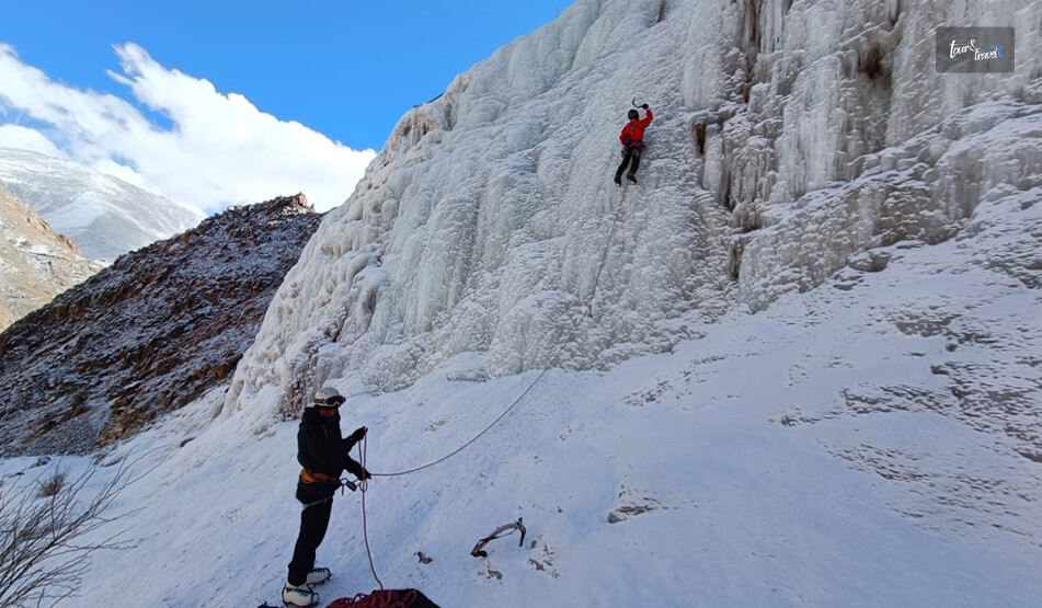
1. Ice:
Of course, you need to worry about ice! In the winter months, melt-freeze cycles turn hiking trails into slippery ice. Similarly, this can also happen on popular tourist routes where snow is compressed over a long period of time.
If you slip on these icy trails, it will lead to bruises and bumps. Moreover, a bad slip and fall can lead to serious wrist, ankle, or back injuries.
As a result, it is best to carry metal-tipped trekking poles and traction for additional stability in such conditions.
2. Avalanches:
In the United States, avalanches (as per avalanche.org) kill between 25 and 30 people every winter. Moreover, the injury rates are much higher.
Most victims are ice climbers, snowmobilers, snowboarders, and backcountry skiers. However, oblivious hikers do get caught in avalanches occasionally.
The worst part? Nearly 95% of avalanches begin on slopes that are between 30 and 45 degrees in steepness.
However, the snow ends up traveling down to the flat terrain – and it even appears to be safe to an untrained eye.
As a result, it is vital to consult topo maps, check trip reports, and talk with local experts before you set out. That is your best shot at safety in the face of an avalanche.
3. Glaciers:
Many of the iconic summits in the United States are guarded by glaciers.
While there are several snowfields across the western part of the United States – mostly misnamed as glaciers – you will find true glaciers mostly in the Pacific Northwest and in the far north.
Moreover, these are active glaciers that moves around, forming cracks with time. As a result, these fissures, A.K.A crevasses, lie under the snow, hidden from the human eye. Naturally, fatal falls – and unexpected ones – become a major possibility.
So, it’s best not to step out on glaciated terrain unless you have some experience in both glacier navigation and snow travel. This also includes improving your fissure-rescue skills.
4. Steep Snow:
The challenge and adventure of climbing snow-covered, steep slopes is certainly thrilling.
Recently, I had the opportunity to try out snow climbing, and while it was thrilling, I can’t overstate the importance of safety and experience.
It’s so much more technical than it appears visually – if you slip even once, you can slide down the steep slope. Also, you have to know:
How can you assess the snow conditions around you?
Use crampons.
Take a fall with the help of an ice axe.
Additionally, it is best to be familiar with avalanches and safety first. Because a majority of snow climbs will require you to cross terrain prone to avalanches.
What To Know Before Planning Your Next Mountain Escapade? 9 Tips That Can Keep You Safe!
Safety in weather extremes, especially in the mountains, requires careful preparation, specialized equipment, and a constant awareness of your body’s condition.
Moreover, the combination of high winds, rapid changes in weather, and freezing temperatures leads to life-threatening conditions. And that too in minutes.
This includes the risk of both frostbite and hypothermia. Moreover, preparing for freezing temperatures is incomplete without strict layering, high-calorie nutrition, and waterproof gear.
And still it’s not enough – surprised? Well, don’t be! Instead, scroll down for the internet’s most comprehensive list to prepare for survival in freezing temperatures in the mountains.
1. Stay Hydrated:
Problem:
Dehydration is very common in freezing temperatures, much like hotter regions with arid weather conditions.
How? The cold weather conditions can easily suppress thirst. But the dry air in the mountains and high levels of physical activity will make your body dehydrated – and this will happen faster than you can possibly imagine.
Moreover, dehydration can lead to dizziness, fatigue, and headaches.
Solution:
As a result, you should try carrying a thermos with herbal teas (like chamomile, tulsi, or ginger) or just warm water with lemon and honey. These can hydrate you, keep you warm from the inside, and boost immunity.
Also, on this note, avoid caffeine or any caffeinated drinks since they will dehydrate you faster.
2. Nourish Yourself:
Problem:
Your body will burn a lot of calories to stay warm in freezing temperatures.
As a result, even if you think that a bowl of hot Maggi seems like an appealing meal for the mountains, it is crucial to balance comfort and nutrition.
Solution:
So, you should focus on energy-dense and high-calorie food items like seeds, whole grains, and roasted nuts to ensure high energy levels in the body.
Moreover, you can consider adding warming ingredients to your food. Ingredients like turmeric, garlic, and ginger can fight cold and improve digestion.
Also, if you do end up eating a steaming bowl, then add boiled eggs or vegetables for a healthy, protein-packed version.
On that note, here’s a list of things you can eat:
Beef jerky.
Trail mix.
Nuts.
Milk chocolate.
Pretzels or chips.
Cheese and deli meat.
Tortillas or crackers.
Pizza slices.
Pumpkin or banana bread.
Peanut butter sandwiches.
3. Protect Your Lips And Skin From Dryness:
Problem:
Cold and dry air is not good for the skin – it strips the skin of moisture. And this in turn leads to dry hands, irritated skin, and cracked lips.
This is highly uncomfortable and causes skin damage if you don’t address it within minutes.
Solution:
As a result, always use a moisturizer that is thick and nourishing before stepping out. Moreover, while doing so, focus on different areas like your face, neck, and hands, which are prone to getting exposed.
Also, do not forget to apply lip balm on your lips – and ensure the lip balm comes with SPF for protection against the UV rays of the sun and the cold, both of which are strong at high altitudes.
In addition, eat food items that have a high percentage of omega-3s. This includes flaxseeds and walnuts, both of which are perfect for hydrating your skin from within.
4. Stay Active For Proper Blood Circulation:
Problem:
When you are absolutely stationary in freezing temperatures, your blood circulation will slow down. This, in turn, makes you feel colder.
Solution:
The only solution here is not to sit in the same spot for too long.
So, try out light activities such as walking, stretching, or even a few squats to ensure proper blood circulation. Also, it feels good to do light physical activities after a long day of trekking.
5. Take Care Of Your Altitude Sickness:
Problem:
At high altitudes, you can expect oxygen levels to fluctuate and drop. This, in turn, can cause fatigue, nausea, or dizziness.
Solution:
You should give enough time to your body – that way, your body will be able to adjust. As a result, it is best to take it easy on day 1.
Moreover, drink lots of water and eat food items that are rich in antioxidants. This includes berries, nuts, and fresh fruits. That way, your body will be able to fight the stress and pressure of altitude.
If you are feeling unwell at any point, don’t push too hard. Rest is very important.
6. Support Your Body’s Immune System:
Problem:
The blend of altitude and cold weather can easily weaken your body’s immune system. This, in turn, will make you prone to illnesses.
Solution:
Incorporate food items that are rich in Vitamin C, like amla or oranges, in your daily diet in the mountains to boost your body’s immune system.
Moreover, warm soups are also great – but ensure these have vegetables, lentils, or even chicken stock. Why? Because it offers warmth, hydration, and nourishment together.
Also, ensure you can sleep well – a good sleep cycle will recharge your body.
7. Look After Your Feet:
Problem:
Remember that cold or wet can lead to chilblains, frostbite, and lots of discomfort.
Solution:
Invest in insulated and waterproof boots. Moreover, you can consider wearing thick woollen socks to ensure your feet are dry and warm.
Also, don’t forget to carry an additional pair of dry socks – that way you can change socks if your feet feel too damp.
In addition, you can try massaging your feet with a nice, warm balm. Why? It will prevent dryness and improve circulation.
8. Breathe Smartly For Avoiding Cold-Air Effects:
Problem:
If you directly breathe in icy, cold air, then it will irritate your lungs.
Trust me on this one! It has happened to me. And then you will start coughing. Some people also feel a tightness in their chests.
Solution:
When you start feeling chilly, try to breathe through your nose and avoid doing it through your mouth.
This will keep you warm, moisturizing the air even before it can reach your lungs. Also, this will help you to keep respiratory problems at bay.
9. Prioritize Mental Wellness:
Problem:
The beautiful solitude of the mountains can be very peaceful. However, at times it can get very overwhelming. As a result, staying healthy mentally is just as crucial as looking after yourself physically.
Solution:
Take some time for yourself so that you can practice mindfulness – and while doing so, don’t forget to appreciate the beauty around you.
Moreover, you can consider carrying a journal for jotting down your reflections and thoughts.
Also, it is healthy to count on your group to stay connected. Why? Sharing experiences together can motivate everyone and lift spirits.
Barsha Bhattacharya builds stories for a living and seeks mountains for everything else. An English major and remote content strategist, she travels every month, structuring her life around movement rather than routine. Her journeys are rooted in mountaineering and rock climbing, with a deep preference for tents over hotels and cold mornings over comfort. Barsha believes the mountains demand clarity, patience, and presence - the same qualities that shape her work. For her, travel is not an escape but immersion: long routes, rough terrain, and nights under open skies where the line between work and wilderness disappears.
For movement to selected countries without any problems and to stay there for a certain period, it is necessary to have a particular authorization document. These are so-called visas, which are ordinary and VIP. The latter are good because they have great power and give the holders a huge range of privileges. The Golden Visa for wealthy investors is one of them. It can be issued in the EU by anyone who wants to, but the main requirement is that you do not have European citizenship. It is necessary to familiarize yourself with all the conditions and peculiarities in detail to avoid problems later in the procedure.
Golden Visa Programs Overview
First, it should be noted that they represent the issuance of a residence permit with subsequent granting of permanent residence status to the country's migration program participant on improved conditions. The holder is entitled to many advantages and privileges that his family members can use later. The status can be obtained with the help of the following:
acquisition of immovable property;
buying back government bonds;
opening a deposit account;
registering your own business;
other contributions to development funds.
You should understand that the Golden Visa programs is a kind of pass that gives the right to obtain a residence permit in a particular country. Such a card can be obtained if you buy a house in the chosen location, make a large investment, or donate a significant amount of money. It also allows access to education in top European universities. Moreover, it is allowed to move freely around Europe. Furthermore, it is an opportunity to live legally in a civilized society with a high standard of living.
The document is issued in several countries, which we will discuss in detail below. Each state has developed its requirements for programs to get the status. It is necessary to familiarize yourself with them more closely, especially if you are planning to move soon, being an investor, and fulfill the critical condition for issuing the card.
Malta
Malta is one of the countries with Golden visas. It is famous for its unrivaled beaches, warm climate, and hospitable locals. It is a top-rated tourist destination and a good choice for those who wish to change their residency. The program looks very attractive for those obtaining a residence permit to contribute to the state's economy. There are several ways - to invest in some property or contribute to the country's budget.
This country is a member of the European Union and Schengen zone and unites in itself:
a thriving economy;
a stable property market;
high-quality social services.
Under the respective program, the decision on the application for a residence permit is often made in a short period - within 4 to 6 months. Once approved, the person is granted the requested one for 5 years with the possibility of an extension. It is worth emphasizing that this can be a pathway to citizenship for the principal applicant and his immediate family as long as all requirements are met.
Cyprus
It is the so-called "Pearl of the Mediterranean". It pleases with its hospitable residents, Adelaide weather, clean, attractive beaches, and stunning scenery. According to the Immigrant Invest Vladlena Baranova expert, candidates with dependent family members can travel to different European corners, live, work, and study wherever they want. Moreover, permanent residence in a given country is not a prerequisite.
Greece
Greece stands out among other EU Golden visa programs. After receiving the card, living anywhere in the country to come on holiday whenever you want becomes realistic. First, it is worth understanding that this is a tourist country, so you can get income from investments by renting out the bought flat or house. Moreover, you can choose, buy an object, draw up documents, and submit them remotely.
Spain
By participating in this program and getting what you want, you can move to the country with your relatives. There is a high quality of life in Spain, a low crime rate, and a good attitude toward foreigners. It is also possible to realize visa-free trips to Schengen countries. In this case, there is no need to obtain a work permit. You can open branches and set up a new company without fears and risks.
Italy
To participate in this program, you must invest the required amount, i.e., 250 thousand euros. It must be invested in strategic economic sectors, e.g., government bonds and charity funds.
Read Also: Which Is The Best Time To Visit Auli? – Travel Guide
Temporarily Unavailable Programs
It became known that the Prime Minister of Portugal announced the end of his country's program. Portugal has indeed decided to eliminate the possibility of obtaining a residence permit through a financial contribution to real estate. However, he still allows foreigners to get it on condition of investing 500,000 euros in local companies or funds not related to real estate. We recommend that you seek help from specialists to avoid problems and misunderstandings while resolving issues.
Read Also:
Best Places For River Rafting In India
Top 10 Best Travel Sites For Tour In 2022
6 Best Family Holiday Destinations In India
There are so many things that most definitely be on your NYC bucket list! And one of those things happens to be visiting the Statue of Liberty viewpoint. Yes, there is more than one. Today, we will be discussing all the best spots to see this historical symbol of emancipation. And not just see - we have also determined where you can take the best pictures.
Come on! Lady Liberty is iconic in NYC! So you can’t just ignore her. It only makes sense to take a few photos of the original First Lady of America. What we liked to call ‘one for the gram!’
Keep reading to find out all the best spots to check out the Statue of Liberty. Snap a few shots for the gram - you just have to stick to the very end!
Visiting The Statue Of Liberty View Point - 10+ Spots To See The Statue Of Liberty (Free Spots Too)
There’s no accurate answer to the very popular ‘how to see the statue of liberty?’ question! Located literally in the south of Manhattan, this Lady of Liberty prefers to chill in the middle of the water. It makes the nearby areas perfect for taking aesthetic photos! But isn’t that the best part of visiting New York?
So many people visit the city that never sleeps in the hope of living a free life. Isn’t that what the Statue of Liberty stands for? When people cross the Atlantic Ocean towards the United States Of America, they see the Statue of Liberty. It gives them hope of the promised land where class doesn’t matter.
So without wasting any more time, scroll down to find out which is the best Statue of Liberty viewpoint!
Brooklyn Bridge:
You don’t need to look for Statue of Liberty views. You can enjoy one of the best views of the Statue on your visit to the Brooklyn Bridge. The Bridge is iconic pop culture and the best part? You can enjoy stunning views of the city skyline. The Bridge serves as a beautiful Statue of Liberty view point. You don’t have to spend a single penny on the same!
Battery Park City Esplanade:
The view of Statue of Liberty from Battery Park in Lower Manhattan is truly one of the best views of the Statue you will get to witness. When you are walking the long stretch of the beautiful seaside sidewalk, it will feel like you have simply stepped inside a black-and-white movie. Plus, it’s the perfect spot for one of those caught-in-the-camera-very-candid pictures!
One World Observatory:
The historic World Trade Center happens to be another beautiful Statue of Liberty view point. It is also located in the Lower Manhattan region. You just have to reach the One World Observatory. Unfortunately, you have to pay around 43 dollars for a basic ticket to the Observatory. But that’s fine because it’s NYC, baby!
Green-Wood Cemetery:
The Green Wood Cemetery is hauntingly beautiful in its own way, but you also get some crazy views of the Statue of Liberty from here. The twisted cobblestone pathways, the graves of famous figures such as Jean-Michel Basquiat or Horace Greeley, and even the breathtaking views of the Statue - all come together to make this place a must-visit on your trip to the city that never sleeps.
Louis Valentino Jr. Park & Pier:
Another Statue of Liberty view point based in Brooklyn, the Louis Valentino Jr. Park & Pier, is located in the Red Hook waterfront, the industrious neighborhood of Brooklyn. This one’s also free, so there’s no reason why you won’t check out the best symbol of American liberty from this spot. You can also enjoy stunning views of Staten Island, Governor’s Island, and the city skyline.
Museum Of Jewish Heritage:
The Museum Of Jewish Heritage is one of the lesser-known spots that offer crazy views of the Statue of Liberty. Another one of the Battery Park Statue of Liberty views, the Museum is entirely devoted to honoring Jews and as a Holocaust remembrance. If you love history, then you can’t miss out on this spot.
Staten Island Ferry:
One of the fun yet lesser-known things to do in New York is to take the ferry from Manhatten to Staten Island. You do not just get to enjoy breathtaking views of the City skyline and Staten Island, you will also have the best view of the Statue of Liberty while you are commuting between Staten Island and Manhattan.
Governor’s Island:
If you are ready to invest around 3 dollars, you can visit Governor’s Island - And you will find yourself at the perfect Statue Of Liberty view point. You just need to reach the hills here and explore the trails. You might just find yourself enjoying not just stunning views of the Statue but also that of the entire Lower Manhattan!
Liberty State Park:
There’s no mystery behind this one. Everyone knows that the Status of Liberty is located in the waters of New Jersey. So New York is not the only place with stunning views of this iconic statue, even the state of New Jersey has some crazy unexplored views. You can also try out some canoeing in the timeless Hudson river.
Brooklyn Heights Promenade:
Another beautiful Statue Of Liberty view point in Brooklyn, the beatific Brooklyn Heights Promenade, sits proudly over the Brooklyn Queens Expressway or BQE. The beautiful esplanade definitely needs a visit as it offers stunning views of the New York Harbor and the Brooklyn Bridge Park.
And It’s A Wrap!
You might have been looking for the one perfect Statue Of Liberty view point, but we have managed to provide you with so many options! One Statue, multiple viewpoints, and that, my friend, is the best part of New York! You don’t have to be happy with one when you can have several - be it your Cosmopolitan or the perfect viewpoint.
So tell us, what do you think about visiting the Statue of Liberty? And if you already have, what was your experience like? Tell us in the comments below!
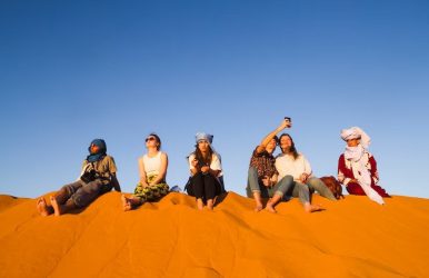
In this blog post we will take you on an extraordinary journey through the mesmerizing desert of Dubai. Join us as we unravel the unforgettable moments that await you on an exhilarating safari trip in this captivating city.
Dubai, known for its extravagant skyscrapers and modern marvels, offers a unique experience amidst the vast expanse of golden sand dunes.
Whether it's the adrenaline rush of dune bashing, the serenity of a camel ride, or the enchantment of a traditional Bedouin camp, Dubai's safari trip promises to leave an indelible mark on your memory.
Excitement of Sand Dashing: A Heart-Racing Expedition
Dune bashing is a heart-pounding activity where skilled drivers maneuver powerful 4x4 vehicles across the undulating landscape. Feel the rush as you slide and bounce over the sandy slopes, experiencing the thrill of each twist and turn.
This off-road adventure is a must-do for adrenaline junkies and offers a unique perspective of the desert's raw beauty. With expert guides at the helm, you can rest assured that safety is paramount as you navigate the sandy rollercoaster.
Enchanting Camel Excursions: A Peaceful Ride across the Sands
Travel back in history and experience the calmness of the desert while enjoying a grand camel journey. These kind animals have played a vital role in Arabian traditions for many generations. Climb aboard your trusty camel and sway gently as it gracefully carries you across the golden sands.
This slow-paced journey allows you to connect with nature, savoring every moment of the peaceful ride.
Under the guidance of skilled caretakers, you can unwind and fully embrace the breathtaking scenery of the desert as you ride the camels.
Sunset Splendor: Witness the Magical Colors of the Desert Sky
Prepare to be awestruck as the desert landscape transforms during the enchanting moments of sunset. As the sun begins its descent, the sky sets ablaze with a myriad of colors - from fiery oranges to soft hues of pink and purple. The shifting sands cast captivating shadows, adding to the surreal beauty of the scene.
Discover an ideal spot and marvel at the mesmerizing sight of the sun descending beneath the skyline, casting a spellbinding radiance over the desert. Capture this unforgettable moment in your heart and on your camera, as the desert reveals its true splendor during the twilight hours.
Arabian Nights: Experiencing the Bedouin Culture at a Traditional Camp
The Bedouin people, known for their hospitality, offer a glimpse into their way of life in this desert oasis. Step into a world of traditional music, captivating dance performances, and aromatic flavors as you enjoy an authentic Arabian feast.
Try your hand at traditional activities like falconry or get a henna tattoo, embracing the customs of this fascinating culture. It's an evening of Arabian enchantment that will leave a lasting impression.
Exploring Desert Nature: Uncover the Intriguing Plants and Animals
Contrary to popular belief, the desert is teeming with life, each adaptation perfectly suited to survive in this arid environment. Discover the captivating plants and animals of the desert while exploring further into its expansive terrain. Discover resilient plants like the Arabian cotton bush and the desert hyacinth, which bloom in the most unlikely of conditions.
Keep your eyes peeled for glimpses of Arabian oryx, gazelles, and even the elusive sand fox. This encounter with desert wildlife provides a unique opportunity to appreciate the tenacity and beauty of nature in an unforgiving landscape.
Sandboarding: Glide Down the Dunes for an Exciting Desert Experience
Sandboarding is the sport for you if you're looking for an adventurous journey on the slopes of the desert. Similar to the popular sport snowboarding, this activity lets you cut through the sand while feeling the wind's surge against your face.
With the right technique and a sense of balance, you can conquer the dunes and experience an adrenaline-fueled thrill. Whether you're a seasoned boarder or a first-timer, sandboarding promises excitement and a unique perspective of the desert landscape.
Arabian Cuisine: Indulge in Delicious Delicacies amidst the Desert Landscape
Set off on a food journey and indulge in the delicious tastes of Arabian dishes amidst the breathtaking desert scenery. Traditional Bedouin-style meals are a feast for the senses, showcasing a fusion of aromatic spices, tender meats, and flavorful rice dishes.
Delight your taste buds with succulent grilled meats, fragrant kebabs, and savory falafel. Sample traditional desserts like baklava and indulge in freshly brewed Arabian coffee. As you dine under the starry sky or in the cozy ambience of a Bedouin tent, you'll experience the true essence of Arabian hospitality and culinary excellence.
Book Desert safari Dubai: desertsafaris-uae
Henna Art and Traditional Dress: Immerse Yourself in the Arabian Culture
Discover the beauty of Arabian traditions through intricate henna art and traditional dress. Adorn your hands with stunning henna designs, created using natural dye extracted from the henna plant.
Immerse yourself in the cultural experience by trying on traditional Arabian attire. You can feel the elegance and grace of these garments as you capture stunning photographs that capture the essence of Arabian culture and create lasting memories of your desert adventure.
Read Also:
Yachting In Dubai – A Memorable Experience
5 Reasons Why People Love Morning Desert Safari In Dubai?
“Sands Of Splendor: Luxurious Desert Safari Experiences In Dubai”


 Related