The Glaciers of Wrangell-St. Elias National Park: Experience The Magnificence Of Nature
BY Sibashree Aug 9, 2024
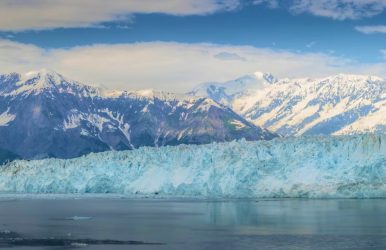
Wrangell-St. Elias, a UNESCO World Heritage Site, is an icy wonderland. It is a place where active volcanoes and the largest glaciers, like Malaspina, coexist, making it “A Song of Ice and Fire.” It also has some of the greatest mountain ranges in the world and mighty rivers. Further, unique geological features and weather conditions have made the national park a land of biodiversity and wilderness with a lot of mammals, birds, fish, and plants. Let me take you on a tour of the Wrangell-St. Elias glaciers and everything the national park has to offer. What Are The Notable Glaciers In Wrangell-St. Elias? Nabesna Glacier, Malaspina Glacier, and Hubbard Glacier are the most notable ones in Wrangell-St. Elias National Park. Along with these glaciers, you can also see glacier features like glacier caves, Jökulhlaups, and ice falls. Let’s briefly discuss the major glaciers and glacier features. Malaspina Glacier Did you know that Malaspina Glacier is the “largest Piedmont glacier in the world?” Designated as a National Natural Landscape in 1968, it spans across 1,075,409 acres. Further, its glacial mechanisms and fluctuations have made it a favorite of explorers. The glacier is also a favorite of space travelers as it looks vibrant from space. In an article published by NASA Earth Observatory on 27th October 2023, we can find, “The dark blueish-purple lines on the ice are moraines—areas where soil, rock, and other debris have been scraped up by the glacier and deposited along its edges. The zigzag pattern of the debris is caused by changes in the ice’s velocity. Glaciers in this area of Alaska periodically “surge” or lurch forward for one to several years. As a result of this irregular flow, the moraines can fold, compress, and shear to form the characteristic textures seen on Malaspina.” Hubbard Glacier Hubbard, “the sleeping giant,” is the largest when it comes to the tidewater glaciers in North America (75 miles long). The glacier gets its name from Gardiner Hubbard, National Geographic Society’s first president. Also called the “Galloping Glacier,” it comes with tranquil blue ice. You can explore Hubbard Glacier through a cruise trip. Visiting the Hubbard Glacier becomes more exciting as you meet the sea otters, whales, sea lions, and bears along the route. Nabesna Glacier With a length of 53 miles, Nabesna Glacier is the “longest interior valley glacier” in the world. However, there are concerns regarding the loss of ice mass in the glacier. A 2007 report says, “Nabesna, the largest glacier in this region (˜1056 km2), lost mass four times faster during 2000–07 than during 1957–2000. Although accelerated, the mass change over this region is slower than in other glacierized regions of Alaska, particularly those with tidewater glaciers.” Glacier Features In Wrangell-St. Elias You will come across many fascinating glacier caves in Wrangell-St. Elias, especially near the Kennecott Mines National Historic Landmark. Further, ice falls, or the fountains of the glacier, move very fast, and it’s fascinating to see how they form seracs or blocks. Also, there are Jökulhlaups, or flooded glacier outbursts, adding to the various glacier features of the national park. Amazing Glaciers of Wrangell-St. Elias National Park Facts Mount St. Elias, the largest peak of the national park, is the second-highest in the world. Mount Wrangell, the only active volcano here, is one of the largest active volcanoes in North America. It has Nabesna Glacier, Malaspina Glacier, and Hubbard Glacier, three of the largest in the world. It is a part of the “world's largest international protected wilderness.” Mid-May to mid-September is the best time to visit this park. Wrangell-St. Elias: A UNESCO World Heritage Site Home to countless glaciers and many high mountains, Wrangell-St. Elias National Park enjoys the status of a UNESCO World Heritage Site, with Kluane, Glacier Bay, and Tatshenshini-Alsek. Also, Wrangell-St. Elias National Park is a part of the “largest non-polar icefield in the world.” You will find Dall's sheep, grizzly bears, caribou, and many other animals roaming in this part of the world. Further, certain geographical and biological factors and “protection and management requirements” make this national park a place of outstanding universal value. Let’s discuss them in detail. Rich In Biodiversity The scenic beauty and geological diversity in the park are outstanding. It has sea mammals and other aquatic animals. Further, you can see many land mammals, birds, and different types of trees in this park. The table below mentions some of the most popular birds, trees, and animals you can see here. Land Mammals Brown Bears Polar Bears Black Bears Mountain Goats Dall Sheep Bison Coyotes Wolverine Porcupine Sea Mammals and Other Marine Creatures Whales Sea Lions Porpoises Harbor Seals Sea Otters Plants (936 Vascular Plant Species) Sedge Family Grass Family Sunflower Family Trees Willows Various Introduced Species Birds Bald Eagles Canada Geese Trumpeter Swans Wilson's Warblers American Robins Home to boreal forest, Wrangell-St. Elias has one of the largest ecosystems in the world. Diverse geological features and unique weather conditions support this sprawling ecosystem or biodiversity. Comes With Topographical Diversity This national park is one of the most diverse in its topographical features. It has glaciers, rivers, river canyons, volcanoes, snow-capped mountains and whatnot! Geomorphological features like hanging valleys, moraines, craters, and calderas also make this national park unique. A Hub Of Active Tectonic, Volcanic, Glacial, And Fluvial Natural Processes Like the entire Alaska, Wrangell-St. Elias is also in an area where tectonic, volcanic, glacial, and fluvial natural processes are common. So, it has active and inactive volcanoes, the largest glaciers, and some prominent fluvial landforms. It has the mighty Copper River, Rivers of Life, and braided rivers formed of glacier water. Final Words Wrangell-St. Elias National Park has the highest glacier coverage among all national parks in America. It also has the active Mount Wrangell volcano, rivers, and wetlands, making it a place of geological interest. Exploring the glacier caves and the ice falls here is a one-of-a-kind experience, and it’s wonderful to see how the richest biodiversity with mammals, birds, aquatic animals, and trees thrives here. So, come and experience the brilliance of nature as you explore the largest glaciers of the world’s largest glaciers, such as Malaspina and Hubbard. Or have you already been to this land of volcanoes and glaciers? Don’t forget to share your experience of the glaciers of Wrangell-St. Elias National Park tours. Wrangell-St. Elias National Park FAQs How Many Glaciers Are In Wrangell-St. Elias National Park? Like the entire Alaska, Wrangell-St. Elias is filled with glaciers. According to the latest count of the National Park Service (NPS), the Wrangell-St. Elias National Park has 3,121 glaciers. Further, these glaciers cover a whopping “6,757 square miles of land.” So, Wrangell-St. Elias has glaciers that cover 60% of all the glacier coverage in American National Parks. Glacier Bay in Alaska is the distant second to Wrangell-St. Elias. The glacier coverage at Glacier Bay is just 1/5th of Wrangell-St. Elias. In addition, Malaspina, Hubbard, and the Bering glaciers, located along the park’s southern margin, are three of the largest glaciers in the world. Having said that, glacier coverage in Alaska is shrinking, and Wrangell-St. Elias is not an exception. From 1985 to 2020, it has already experienced a 5% reduction in its glacier coverage. How many People Visit Wrangell-St. Elias National Park Each Year? The National Park Service has a record of visitors to Wrangell-St. Elias National Park since 1982. Since then, this park has been enjoying thousands of footfalls every year. 2023 was one of the topmost years in terms of number of people visiting Wrangell-St. Elias. It had 78,305 visitors in 2023. In 2020 (the Covid-19 era), the park had 16,655 visitors. From 2021, the number of visitors has increased consistently. (Source) What Is Unique About Wrangell-St. Elias National Park? With the largest glaciers and volcanoes in the world, Wrangell-St. Elias is unique because of its geographical features. It is also one of the most prominent hubs of biodiversity. Thanks to its extensive glacier and volcanic coverage and rich wildlife, it has earned the status of a UNESCO World Heritage Site. Among glaciers, Hubbard (one of the largest in the world and the largest tidewater glacier in North America) and Malaspina Glacier demand a special mention. The Mount Wrangell volcano in this park is still active, and some other volcanoes here are Mount Drum, Capital Mountain, Skookum Creek Volcano, etc. Further, it has an endangered sea mammal, Steller Sea Lion, and other marine animals. Bears, mountain goats, and sheep are common land mammals roaming here. Also, you will find birds like the American robins, Wilson's warblers, and dark-eyed junco in this national park. What Is The Highest Peak In Wrangell-St. Elias? Mount St. Elias is the highest peak in Wrangell-St. Elias. With a height of 18,008 feet, it is also the second-highest peak in North America. Having said that, Wrangell-St. Elias National Park celebrates the presence of four major mountain ranges in the world. It has the eastern part of the Alaskan Range, St. Elias, Chugach, and Wrangell. Why Is Wrangell-St. Elias Protected? Wrangell-St. Elias is protected to “preserve and protect ecological integrity and heritage resources of a vast ecosystem in south-central Alaska, while providing for public use in a wilderness setting.” So, it is protected to preserve the local geology and diversity of the landscape with glaciers, volcanoes, and wetlands. It is also a measure to preserve wildlife and its inhabitants. Also read Ultimate Guide to Your Next Family Vacation in Israel. Paris Transforming Historical Sites Into Olympic Venues. Whales And Sea Lions! Exploring Wildlife At Kenai Fjords National Park.


