Related
Explore Human History And Wildlife With Backcountry Camping In Gates Of The Arctic National Park
BY Sibashree Aug 12, 2024
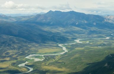
Gates of the Arctic National Park is where the Brooks Range and the Tundra landscape come to life with wilderness and vivid topography. This national park is a place of topographical diversity with the coexistence of mountains, glaciers, rivers, lakes, and marshy lands. A home to nomadic people for more than 13,000 years, the Gates of the Arctic is a prominent example of how human lives can be dependent on wilderness or nature. Many visitors love backpacking and trekking in this national park. Further, many stay in camps in the backcountry to experience its rich wildlife despite the challenges. Do you want to know why camping in the backcountry is worth the hardship? Does the national park have camping sites? Find the answers to all your questions in this guide. Knowing The Gates Of The Arctic National Park (Why Camping Here Is A Great Experience) The Gates Of The Arctic National Park is a paradise for wilderness travelers. The intriguing land of Tundra, embraced by jungles, mountains, and rivers, makes camping in the backcountry worth all the effort. Gates Of The Arctic Geography You can explore the arctic geography of this national park by trekking or by air. Tundra peaks and the Schwatka Mountains region of the Brooks Range ensure a humbling experience. You trek to Mount Igikpak, a glacier-carved peak with an 8,510-foot elevation. Another mountain to have glaciers in this region is Mount Arrigetch. Even backpacking and trekking to Mount Doonerak have a distinct charm, as the mountain is the quintessence of wilderness and unadulterated beauty. Further, this national park has six designated wild rivers. Those are: Alatna River John River Kobuk River Noatak River North Fork of the Koyukuk River Tinayguk River Alatna and Noatak are great for canoeing. If you want more adventurous pursuits, you can try rafting in Nigu (to the north) and Kobuk (to the west). Gates Of The Arctic Wildlife The Gates of the Arctic is home to many mammals and birds. The Alaska Department of Fish and Game says, “Forested southern foothills rise to limestone and granite peaks more than 7,000 feet high in this remote wilderness park. North of the peaks, clear water rivers run through glacier-carved valleys; and Tundra, covered with wildflowers during the brief northern summer, stretches toward the Arctic Ocean. Many of the nearly 500,000 member Western Arctic caribou herd migrate through the park each fall. Brown and black bear, wolf, Dall sheep, lynx, moose, wolverine, and red fox live here year-round. In the spring, the park hosts migratory birds from Europe, South America, Asia, tropical archipelagos, and the continental U.S.” Other animals found in this national park are grizzly bears, Dall sheep, and musk oxen. Among the birds, Tundra swans, common loons, and golden eagles are the most common. Further, if you enjoy the playfulness of aquatic animals, watch out for graylings, trouts, sheefish and salmon. Gates Of The Arctic And Human History The Gates of the Arctic is a prominent place for archaeological research. The study and interpretations of the museum collections depict how people have been surviving in the Brooks Range for around 13000 years now. Along with Inupiat, Nunamiut, and Athapaskan descendants, you will also find many non-native Alaskan people in this region. These people have always been dependent on fishing and hunting. The wilderness of the Gates of the Arctic is the foundation of their livelihood. What Is The Best Camping Near Gates Of The Arctic National Park? With marshy lands and tussocks, Arctic Tundra has a vulnerable landscape and it is difficult to find a steady spot for setting up camps or tents. Also, the existence of wildlife in a remote location and dense vegetation make the space unsuitable for camping. So, there is NO CAMPING SITE in the Gates of the Arctic National Park. There are designated areas in the backcountry for camping. However, you will have to strictly adhere to the rules and regulations of the national park when putting up a tent. You must also attend the orientation program and be particular about the gear, food, and safety essentials to be carried. With permission from the park authority and the National Park Service, you can set up tents near the Arctic Interagency Visitor Center in Coldfoot or around Wiseman and Bettles communities. However, while camping in the backcountry, you will have to keep the following factors in mind. Be respectful to the local communities like the Koyukon Athabascan Indians or Nunamiut. Their livelihood depends on the wilderness. There are no provisions for running water, a dump station, or restrooms. Your phone network will be unavailable in this location. You have to carry all your trash back as you leave the camping site. You cannot adulterate the pristineness of the location. If you have plans for camping in the backcountry near the Gates of the Arctic, summer is the best season. The temperature is a little moderate on these days, and sunnier days make all outdoor pursuits in the park easier for you. Did You Know? The Gates of the Arctic National Park is the second-largest national park in the USA. It stretches over 13,000 square miles. You can see aurora borealis from this park if you visit between November and March. July and August are the best months to visit Gates of the Arctic National Park for hiking and backpacking. Bob Marshall, a wilderness advocate, named this national park “Gates of the Arctic.” Final Words Unlike popular national parks like the Biscayne National Park or the Kenai Fjords National Park, the Gates of the Arctic National Park does not have many visitors yearly. In 2023, only 11,045 tourists flocked to this place. (Source) With a diversity in topography and wildlife and an association with human history, this park has much to explore. However, the extreme trekking conditions and wilderness make it far from an easy excursion or trekking experience. Despite the absence of campgrounds in this park, you can camp in the backcountry at the designated spots in the fields. However, only an experienced backpacker should try it with proper orientation and extra safety measures. Have you ever been to this wild and intriguing national park? Do you have any camping experience in the backcountry? Don’t forget to share your experience with us! Gates Of The Arctic National Park FAQs Can You Camp In The Arctic National Wildlife Refuge? Only backcountry camping is possible in the Arctic National Wildlife Refuge. The absence of roads, villages, or facilities makes this area unsuitable for having designated campsites. Backpacking and hiking are the best ways to explore this vast landscape with rich wildlife and geographical interests. Can You Stay In Gates Of The Arctic National Park? You can stay or try backcountry camping near the Gates of the Arctic National Park. Undefined terrains, wilderness, and a lack of modern amenities make it risky to put up camps in the national park. Even to camp in the backcountry, you will need the highest outdoor survival skills. The arctic ecosystem, topography, and weather conditions are different, and if you are confident enough to stay in the backcountry, plan in advance and get in touch with the Park and Preserve authorities for updates and advisories. How Much Does It Cost To Visit The Gates Of The Arctic National Park? You don’t have to pay entry fees to visit the Gates of The Arctic National Park. However, you must attend the backcountry orientation program at any of the visitor centers. In this way, the Gates of The Arctic National Park is different from other national parks as most of them demand an entrance fee. How Difficult Is It To Get To The Gates Of The Arctic National Park? The Gates of the Arctic is a wilderness park. So, as you enter the park, hiking is the best way to explore. Remember, it is home to the Schwatka Mountains region of the Brooks Range and the highest peak here is Mount Igikpak with an 8,510-foot elevation. So, exploring the national park is not going to be a cakewalk. A lack of established trails further makes hiking difficult. Further, there are six designated rivers, including Koyukuk and Dietrich, in this national park. So, you will have to pass through multiple meandering river crossings. The water levels of these rivers keep fluctuating throughout the season. They are furious throughout the spring season. Tussocks, marshy lands and dense vegetation are other hurdles to your fast movement while trekking. Do you want to visit the backcountry? You can take a bush plane operated by permitted pilots with knowledge of the region. What Is Special About Gates Of The Arctic? The Gates of the Arctic is special because of its geographical uniqueness, rich wildlife, and significance in human history. The glacier-carved valleys, rivers, and ancient trails make the Gates Of The Arctic a favorite destination for backpacking and hiking. Thanks to its geographical typicalness, you will meet many animals and birds. The adorable grizzly bears will be seen feeding, and the musk oxen are another unique animal you must watch out for. If you are a birder, you will love watching the golden eagles, Tundra swans, or common loons. Near the Nigu River or throughout the park, you will find stone fences and camping rings. These are a testament to how Inland Eskimos or Nunamiut have lived in this region for thousands of years. They survived on fishing and hunting. In addition, as I pen this guide, I must tell you that the Gates Of The Arctic National Park is going to celebrate its 45th anniversary of designation next year. First, it became a national monument on 1st December 1978. In 1980, it became a national park and preserve. Also read Italy: Is Florence flat or hilly? Ultimate Guide to Your Next Family Vacation in Israel. The Glaciers of Wrangell-St. Elias National Park: Experience The Magnificence Of Nature.