Are you thinking about visiting Montana National Parks but are not really sure about which ones should you visit while you are there? Well, there is no need for you to worry. I have you covered!
There are a number of national parks that are located in the United States. Whether you want to check out the national parks in Wyoming or Zion, the list is endless. But if you want to try out a new place, Montana might just be the right one for you!
In this article, I will be focusing extensively on the best national parks in Montana that you must visit when you are in the states. So, if that is something that you want to know, keep reading the article till the end…
Best Montana National Parks That You Must Visit!
The fourth-largest state in the US, Montana, lies in the northwest of the country on the border with Canada. It is pretty sparsely populated. It boasts delightfully diverse landscapes. The west is very mountainous. While the east’s endless plains and prairies are only occasionally punctuated by breathtaking badlands and bluffs.
Hidden away among its wild and remote realms are incredible wildlife species. There are moose, grizzly bears, and mountain lions all inhabiting its numerous national parks and state parks.
Are you planning to travel to the States and Montana, to be specific? You need to check out this list of the best Montana National Parks that you need to visit in 2023:
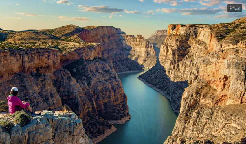
1. Bighorn Canyon National Recreation Area
Bighorn Canyon National Recreation Area sprawls over a vast zone and straddles both Montana and Wyoming. It is home to stunning scenery and landscapes. The area is made up of two delightfully distinct districts. It is a treat to explore, with a wealth of recreational activities to try out.
The main feature of the park is the breathtaking Bighorn Canyon. It towers over the large lake and roaring river of the same name. Its craggy cliffs form a formidable backdrop to the tranquil waters below, which offer fantastic fishing, kayaking, and boating.
Hiking and camping are very popular. However, the area also has a range of archaeological and cultural treasures to check out. As well as being home to historic ranches, a third of its area is located on the Crow Indian Reservation. Part of the park is a range for wild horses. Visitors can learn all about its history, geology, and nature at one of the site’s two centers.
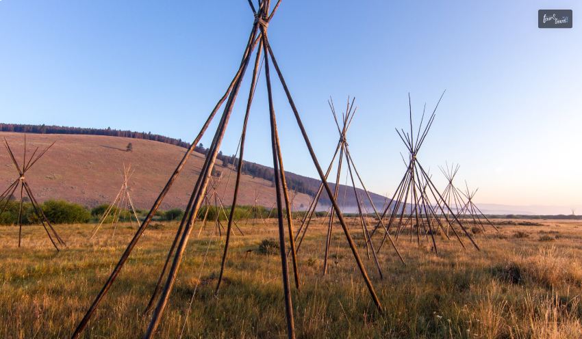
2. Big Hole National Battlefield
The Big Hole National Battlefield is the location of the battle that took place on August 9th and 10th during Nez Perce Flight of 1877. By early August, over 800 nimí·pu· (Nez Perce) and over 2,000 horses were passing peacefully through the Bitterroot Valley after crossing Lolo Pass into Montana. Their leaders believed the military would not pursue them even though many had premonitions warning otherwise. When the nimí·pu· arrived at ?ıckumcılé.lıkpe (known today as Big Hole National Battlefield) on August 7th, they did not know the military was close behind them. On the morning of August 9, 1877, U.S. troops surprised the sleeping nimí·pu· with a dawn attack on the encampment. And that is where and when everything happened that made this area a national historic place.
The park’s visitor center offers museum exhibits, a film, and a book sales area. The award-winning film Weet’uciklitukt: There’s No Turning Back, Battle at Big Hole provides an introduction to the Nez Perce Flight of 1877 and the battle that took place at this site. The film is shown throughout the day and is close-captioned. Audio and braille guides are available upon request.
Big Hole National Battlefield is one of the 38 sites that make up the Nez Perce National Historical Park. Together they tell the story of the nimí·pu· (Nez Perce). These sites are spread over much of the traditional homeland of the nimí·pu· in present-day Idaho, Montana, Oregon, and Washington. Staff are located here at the Big Hole National Battlefield, as well as at the visitor center in Spalding, ID, and at the Bear Paw Battlefield. To visit all of the park sites could take a substantial amount of time and cover many hundreds of miles.
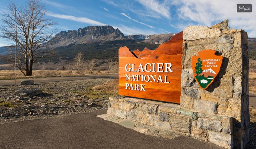
3. Glacier National Park
Home to stunning scenery, landscapes, and nature, the gorgeous Glacier National Park can be found in the northwest of Montana on the border with Canada. Founded in 1910, it protects a vast swathe of unspoiled wilderness and fully deserves its nickname, the ‘Crown of the Continent’.
Very mountainous, it is home to two rugged ranges, with vast valleys and rocky ravines left behind by the gigantic glaciers after which the park is named. Dotted about these damaged yet delightful landscapes are over 130 twinkling turquoise lakes, with gorgeous waterfalls and sparkling streams found here and there.
As over half of the park is coated in verdant forests, it is a great place to go wildlife watching with moose, mountain goats and grizzly bears inhabiting its isolated areas. With scenic trails weaving their way amidst the towering trees and mountains and cozy campsites to stay at, Glacier National Park really is one of the most awe-inspiring places to visit in the whole of the States.
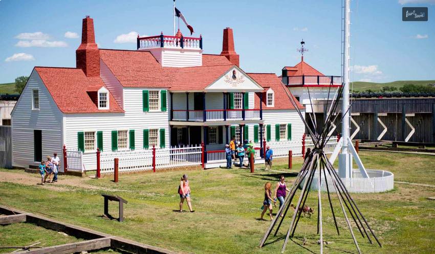
4. Fort Union Trading Post National Historic Site
Next on the list of the best Montana National Parks is Fort Union Trading Post National Historic Site. Between 1828 and 1867, Fort Union was the most important fur trade post on the Upper Missouri River. Here, the Assiniboine and six other Northern Plains Tribes exchanged buffalo robes and smaller furs for goods from around the world, including cloth, guns, blankets, and beads. A bastion of peaceful coexistence, the post annually traded over 25,000 buffalo robes and $100,000 in merchandise.
Fort Union Trading Post National Historic Site and its visitor center in the Bourgeois House are open daily throughout the year except for Thanksgiving, Christmas, and New Years Days. The Trade House, including the trade room and the clerk’s office, is open seasonally.
There are a number of things that you can do here. One of them is visiting the Fort Union’s Trade House, which was one of the most important buildings at Fort Union. It was in the Reception Room where Tribal leaders met with the American Fur Company Traders to discuss the terms of the trade and also where stories were told, and small feasts were held.
Apart from that, you can also plan a great trip with your kids as they can become a Jr. Ranger and Jr. Trader at this historic National Park.
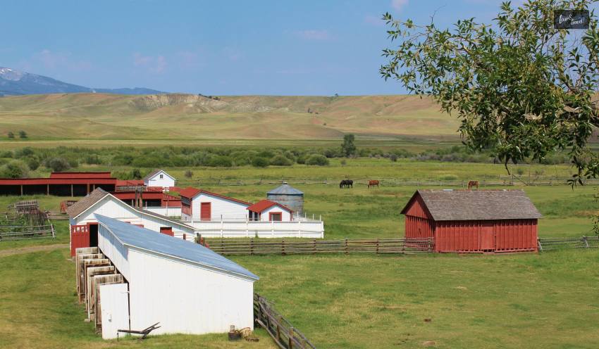
5. Grant-Kohrs Ranch National Historic Site
Located almost equidistant between Missoula and Bozeman is the Grant-Kohrs Ranch National Historic Site, which commemorates the cattle industry and cowboy culture of the American West. Lying on the banks of the charming Cottonwood Creek, this colossal living history ranch now offers a fascinating look into the frontier cattle era that shaped the nation.
Founded in 1862 by the Canadian fur trader Johnny Grant, the ranch was later bought as well as expanded by the successful cattle baron Conrad Kohrs. At its zenith, over 50,000 head of cattle roamed about his ranch, which sprawled as far as the eye could see.
Nowadays, visitors can tour around its historic buildings and see the ranch in operation. Blacksmiths as well as cowboys use techniques that would have been used in the 19th century.
6. Little Bighorn Battlefield National Monument
Lying about an hour’s drive to the east of Billings, this moving national monument and memorial commemorates the famous Battle of Little Bighorn. It was here on June 25 and 26, 1876, that General Custer made his ‘last stand’ and lost his life alongside many of his cavalry at the hands of the local Native Americans.
At the sprawling battle site, visitors can learn all about the epic encounter that came to symbolize the clash of cultures. The Native Americans fought to protect their nomadic way of life and stop themselves from being forced onto reservations. It was a short but momentary victory for the Native Americans against the ever-expanding advances of the US Army.
Through interesting and informative tours, you’ll learn all about the battle as well as its aftermath. Moreover, you will also learn about the legendary Lakota leaders Crazy Horse and Sitting Bull as well. In addition, you can visit the numerous markers and memorials scattered about what is now part of the Crow Indian Reservation.
7. Lewis & Clark National Historic Trail
Also considered to be one of the best national parks in Oregon, the Lewis and Clark National Historic Trail winds nearly 4,900 miles through the homelands of more than 60 Tribal nations. It follows the historic outbound and inbound routes of the Lewis and Clark Expedition of 1803-1806 from Pittsburgh, Pennsylvania to the Pacific Ocean. Follow the trail to find the people, places, and stories that make up the complex legacy of the expedition.
Boasting lots of large limestone caverns and stunning stalactites as well as stalagmites, Lewis & Clark Caverns State Park makes for a spectacular sight. Located just under an hour’s drive to the northwest of Bozeman, it is one of the most popular parks to visit in the state.
First documented by the Lewis and Clark Expedition, after which it is named, the caves cover a substantial underground area. It has illuminating tours that take you around its most fascinating features. Lit up by flickering candles and fairy lights, its subterranean sculptures and formations are a treat to explore.
Above ground is equally delightful. The state park’s lovely woods and shimmering streams lend themselves perfectly to hiking. It also offers mountain biking, and camping, with fishing and canoeing also on offer.
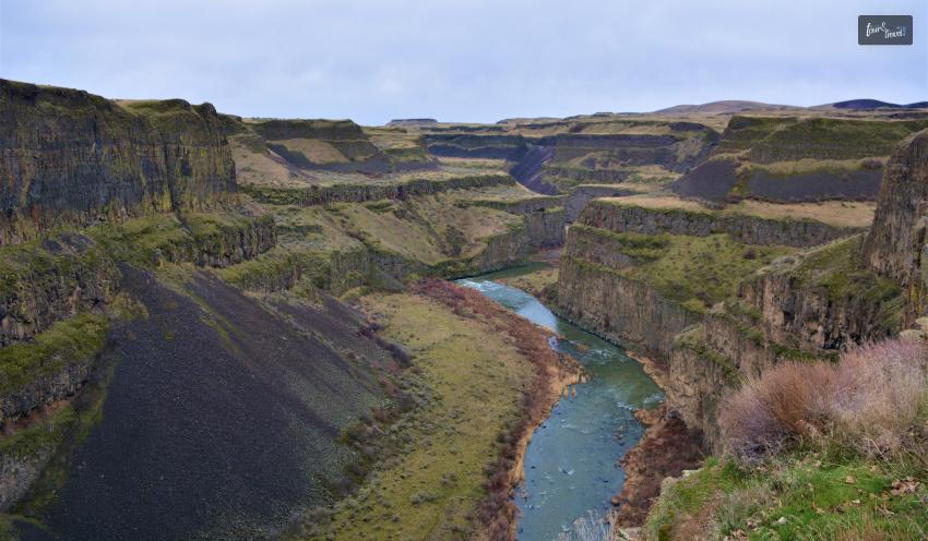
8. Ice Age Floods National Geologic Trail
Glacial Lake Missoula, a 3,000 square-mile body of water encircling Missoula, Montana, was a result of an ice dam in northern Idaho. It happened at the conclusion of the last Ice Age, between 18,000 and 15,000 years ago. Floodwater came out when the dam burst, traveling across Washington, Oregon, and the Columbia River before reaching the Pacific Ocean. The Ice Age Floods affected the people and terrain of the Pacific Northwest, profoundly.
The majority of geologists thought that glaciers and streams slowly eroded rock formations to create Washington’s Channelled Scabland. Geologist J Harlen Bretz postulated that cataclysmic floods were responsible for the formation of the Channelled Scabland after finding geologic data that contradicted this theory.
Bretz’s theory was initially mocked, but it was later proven correct thanks to new technology like satellite photography. By the 1970s, everyone agreed that the Ice Age Floods were to blame for the ravaged terrain of the northwest United States.
Today, the terrain is littered with remnants of these Ice Age Floods. It includes massive basalt coulees, dry falls, and big boulders. They have traveled hundreds of miles, high water lines, as well as tremendous current ripples. The Ice Age Floods National Geologic Trail includes spectacular examples of cataclysmic flood geology, breathtaking landscapes, and locations for scientific study.
9. Lone Pine State Park
Lying just to the southwest of Kalispell is the lovely Lone Pine State Park. It looms over the city and Flathead Valley. As it is home to wonderful nature and scenic trails, it is very popular with locals and tourists. It also has plenty of recreational activities on offer.
Founded in 1941, the park boasts delightful landscapes, with flower-filled meadows and lush forests coating its hilly confines. Reaching 1,110 meters in height, there are more than ten kilometers of trails to explore. It also has fabulous vistas visible from its upper reaches.
Besides hiking, mountain biking, and horseback riding along its peaceful paths, visitors can go wildlife watching and birdwatching. In addition, there is an archery range and volleyball court to try out. Cross-country skiing and snowshoeing are on offer in the winter months.
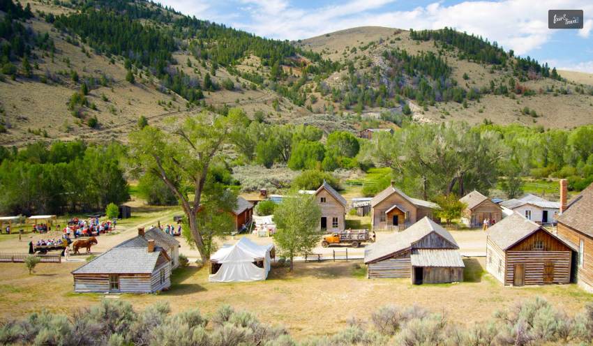
10. Bannack State Park
Once a thriving mining town, Bannack became a ghost town as the seams of glittering gold ran out, and so did the prospectors moved on. Set in a scenic yet remote spot in the southwest of the state, the eerie yet enticing ghost town is now under protection as part of a state park.
Nestled away among Montana’s majestic mountains are more than 50 decaying buildings for visitors to explore, with log cabins lying alongside a school, hotel, and Methodist church. Although they have long been abandoned to the elements, most of them are in remarkably good condition. As such, it makes for an unsettling experience wandering around the empty streets.
One of the best times to visit is in July, during the ‘Bannack Days.’ Re-enactors transform the town into what it would have been like during the gold rush. The rest of the year, visitors can take tours of Bannack or rent bikes and set off hiking from the nearby campsite.
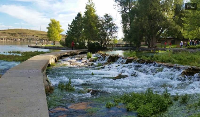
Giant Springs State Park lies just to the northeast of Great Falls on the banks of the Missouri River. It has sparkling springs all around, from which it derives its name. It is a top-rated place with many recreational activities on offer. That is mostly due to its proximity to the city and its peaceful and picturesque nature.
Blackfeet Nation has used Giant Springs for centuries. Moreover, it is one of the largest freshwater springs in the States. First described by the Lewis and Clark Expedition in 1805, its waters originate in the Little Belt Mountains. It took around 3,000 years to travel the 100 kilometers underground to surface again at the springs.
Besides visiting the springs, visitors can wander around the park’s gorgeous green spaces. They explore the scenic shoreline of the river. As well as its picnic areas and playgrounds, it also offers some great fishing, boating, and birdwatching.
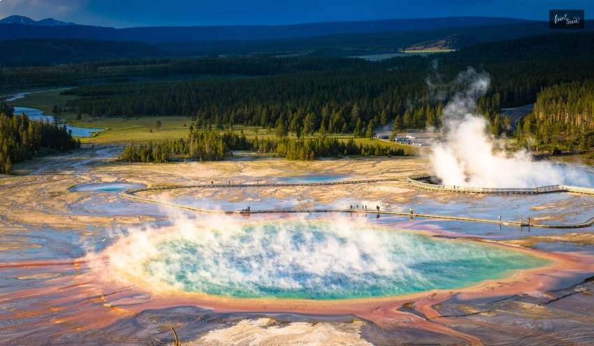
12. Yellowstone National Park
Last but definitely not least, we have another immensely famous option. It is a very popular and widely visited Yellowstone National Park.
Most of Yellowstone lies within the wilds of Wyoming. Some picturesque parts of the popular park sprawl over into Idaho and Montana. An absolutely incredible place, it is awash with astounding natural sights. There are mighty mountain towers above sweeping valleys, verdant forests, and roaring rivers.
The oldest national park in the world came to be in 1872, delighting and dazzling countless generations ever since. Its diverse and dramatic scenery is spectacular. However, it is most known for its more than 10,000 geysers as well as hot springs. There are also thermal features dotting its craggy confines.
Of these, one of the most popular is the Grand Prismatic Spring due to its kaleidoscopic colors. Old Faithful never fails to amaze with the staggering size and scale of its spurting spring. Moreover, you cannot miss out on Yellowstone National Park. It has lots of wildlife residing within its remote realms and exquisite hiking, camping, and boating on offer.
Wrapping It Up!
In case you were searching for the best as well as must-visit Montana national parks, I hope that this article has been of help to you. If there are any other queries related to the same, feel free to let me know. All that you need to do is scroll down till you reach the bottom of the page. Then leave your queries and suggestions in the box below.
Ankita Tripathy loves to write about food and the Hallyu Wave in particular. During her free time, she enjoys looking at the sky or reading books while sipping a cup of hot coffee. Her favourite niches are food, music, lifestyle, travel, and Korean Pop music and drama.
Yes, Houston is worth visiting for an eclectic experience. The fourth-largest city in the USA is a cosmopolitan area. So, you can explore various cultures and cuisines in the city.
Further, the answer to what to do in Houston is extensive, including a visit to the Houston Museum of Natural Science or the Space Center of Houston.
Also, Houston is a year-round travel destination, with each season spilling a different charm. For example, February to April or September-November are the best months to visit Houston. Moderate weather conditions make these months ideal for exploring the city.
At the same time, winter, or December to February, is not freezing in Houston. The average temperature here remains between 6-17 degrees Celsius during the winter months. So, many people visit Houston in winter to beat the crowd and chill.
Nevertheless, Houston stands proud of its places of attraction, irrespective of the time or season of your visit. Here, we have curated the best places to visit in Houston, confirmed by a local travel expert.
What To Do In Houston? You Cannot Miss These Activities In This Texas City
As I was saying, Houston is a melting pot for many different things. So, despite remaining true to its Texas route, it offers you world-class luxury in its fine dining restaurants and museums.
Furthermore, Houston has 25 distinct neighborhoods. So, almost every 50 miles, you will get to be familiar with different cultures.
So, are you ready for a truly eclectic experience? Let’s check out what to do in Houston this season.
1. Visit The Space Center Houston
Address: 1601 E NASA Pkwy, Houston, TX
Contact Number: +1 281-244-2100
Hours Open: 10 AM to 5 PM
The Space Center Houston is currently basking in the glory of the ongoing Galaxy Lights presented by Reliant. This space-themed holiday live show started on 16th November 2024 and will continue until 5th January 2025. (Lights timing: 6-10 PM)
Upcoming Events At Space Center Houston Home School Day December 2024 - 13th December, 2024, 9 AMThought Leader Series | Hearing The Universe: The Art Of Space Sophistication - 18th December 2024, 6:45 PM
Further, this show promises experiences that transcend the boundaries of the Earth. In addition, there have been highlights on the new collections of the museum. OSIRIS-REx Sample has, of course, been the highlight among them.
NASA collects the OSIRIS-REx Sample from Bennu. Bennu is an asteroid, and it’s 4.5 billion years old.
Moreover, the Space Center Houston has many year-round exhibits, including the Starship Gallery, Spacesuit Collection, and the replica of Independence mounted on the original NASA 905 shuttle carrier aircraft.
2. Explore The Houston Museum of Natural Science
https://www.instagram.com/p/C8XVl9HOUTi/?img_index=3
Address: 5555 Hermann Park Dr, Houston, TX
Contact Number: +1 713-639-4629
Hours Open: 9 AM to 5:30 PM
The Houston Museum of Natural Science always hosts special events or exhibitions. For example, the current special exhibitions are Death by Natural Causes based on Natural Born Killers and Matter & Motion: Quantum Chemistry to Astrophysics.
Furthermore, there are many permanent exhibits at the museum. For instance, take Alfred C. Glassell, Jr. Hall. It is an ode to Alfred C. Glassell, Jr. He was a philanthropist, and he was passionate about conservation.
The highlight of this exhibition on the Tumbesian fish species. You cannot especially miss the black marlin that used to weigh 1560 pounds. This black marlin also made a grand appearance at the The Old Man and the Sea movie in 1958.
Another section of permanent exhibits at the museum are The World Around Us:
From Butterflies to Biomes. If you are a curious explorer or someone fascinated by the evolution of lives, you will love these interactive exhibits with infographics.
3. Visit The Buffalo Bayou Park
Address: Shepherd Drive to Sabine Street between Allen Parkway and Memorial Dr, Houston, TX
Phone Number: +1 713-752-0314 (Extension: 301)
Open Hours: 6 AM to 11 PM
Located in Houston Downtown, the Buffalo Bayou Park will offer you a quiet retreat. It is stretched over a 160-acre landscape. It is a native landscape and with acres of green space, it’s great for a walk with your pets and biking.
You can even visit the park with your family for a fun picnic and relaxation time. You will even love the public art displays here.
Moreover, you can explore the park by water. Kayaking and canoeing are popular outdoor activities in the park. The Buffalo Bayou Kayak Tours is in charge of kayaking, canoeing, and boat rentals at the park, and you must get in touch with them.
Exploring The Culinary Landscape Of Houston | What To Do In Houston As A Foodie
https://www.instagram.com/p/CNLSeWGp2Ks/
You have to explore the culinary excellence of Houston if you want to be familiar with the cultural richness of the place. Further, the Visit Houston data says that the city has close to 13000 restaurants from which you can try cuisines of 70 countries.
So, there is no wonder in travelers seeking unique culinary experiences in the city. In addition, the market data for food tourism looks the most promising, with a projected CAGR of 15.20% from 2023 to 2033.
Moreover, Houston is a place where tourists spend 1/3rd of their tour budget on food. It’s hard to avoid the allure of the cakes, lamb tartare, fish tacos, and lobster pies.
Therefore, when it comes to what to do in Houston, you must consider exploring some of the finest restaurants in the city. At Tour and Travel, we have curated some names backed by our love for Houston cuisine, Yelp rating, and suggestions from local experts.
Name of Houston RestaurantsAddressPhone NumberNancy's Hustle2704 Polk St Houston, TX (346) 571-7931Traveler's Table520 Westheimer Rd Houston, TX(832) 409-5785The Ginger Mule449 W 19th St Ste C200 Houston, TX(713) 876-4768Grotto Downtown1001 Avenida De Las Americas Ste A Houston, TX(713) 658-0752
That’s pretty much from me if you want to know about what to do in Houston now. Enjoy your Texas holiday to the fullest!
Also read
Ultimate Guide to Your Next Family Vacation in Israel.
Boat Charter Miami: Essential Tips for a Great Experience.
You Cannot Miss These Things To Do In Wilmington, NC (With Tour And Travel Tips And Tricks)
Every year hundreds of thousands of tourists get ready to head to Thailand, as the Land of Smiles continues to be immensely popular. It truly has something to offer for everyone, whether culture, history, relaxation, or excitement is being sought after. In order to escape from our mundane life, we are always in search of an enthralling destination, and Phuket is surely the one.
Many love island holidays, being near the sea, enjoying beaches, or perhaps getting close to nature by indulging in diving and other water sports. A perfect way to enjoy such activities is by choosing a luxury pool villa Phuket can provide for the following 6 reasons.
A luxury pool villa in Phuket will offer you better privacy and comfort and allow you to spend more time by the seaside.
Top Six Reasons To Opt For A Lavish Pool Villa In Phuket
Who doesn’t want to indulge in pristine beachfront lavishness in a picturesque destination like Phuket? With the widest availability of sophisticated luxury villas and sea-facing rooms, you would surely don’t want to miss out on this fun. So, listed below are six reasons that you would make you book your tickets to Phuket right away and also select a sumptuous pool villa.
A Wonder Land Between The Oceans
Phuket is a dream destination, located in the south of Thailand by the beautiful blue waters of the Andaman Sea and with a wealth of golden sandy beaches to enjoy. It has a rich history intertwined with nightlife that is renowned around the world. Endless restaurants serve amazing food, while there are countless activities to entertain the whole family.
It is the total holiday experience with breathtaking scenery easily navigable for all to enjoy. Also, you get a home-like atmosphere that is unmatched by any trip experience. Certain resorts in Phuket offer you the feeling of being at home and in a relaxed state of mind.
For families or for couples who wish to maintain their everyday schedule while they are on the trip, this might just be the perfect plan.
Privacy
The last thing you would ever want on your honeymoon is to be looked at by 6000 strangers on the road while you are drenched in the pool. Privacy is the next big benefit that luxury pool villas offer. With a calm ambiance where there is no disturbing crowd, opting for a private pool villa is worth the hype.
To get the most out of a vacation on this piece of paradise, a villa with its own private villa, generally set in the rolling emerald hills overlooking the ocean, is the perfect base. What could be a better start to the day than waking as the sun rises and diving into the pool with sea views? Hopefully, all travelers will have made the right calls as to what to put into their makeup bag for the vacation.
An Escape From The Reality
Lying back and rewinding might be high on the list of those wanting to forget about their normal life and drift away while enjoying a read by the pool with some cold refreshments before the sun sets on another stunning day.
Working 10 hours a day for 365 days is not how you should live your life. Taking a relaxing escape by the beach acts as a refreshment for another year. And especially with locations like Phuket, your travel will be the most memorable one.
Unmatched Service
The service and attention that guests will receive are second to none. A villa manager who speaks English is always on hand, and they will act as a concierge throughout the stay, ensuring that every assistance possible is provided. They can provide shopping, book restaurants, and arrange excursions to take away any hassle of the stay.
Maybe a visit to a water theme park might be on the agenda. Those assisting you in a luxury pool villa are usually professional people who know how to take care of their guests. You can even ask them for security, customized meals, and party arrangements.
Quality Time By The Seaside
What nicer way to make the most of the villa than enjoying a barbeque or lunch? Many have their chef included, who will make all the arrangements and go to purchase the ingredients, while a daily breakfast is also often included. This, along with all the modern amenities any guest could wish for, adds up to a perfect vacation.
Resorts offer endless facilities that you can enjoy with your family by the ocean side. Try barbequing, taking a walk in lush gardens, or tasting wines and liquours.
Great Deals During The Peak Season
Booking through professionals who understand what their customers want and can provide the very best amenities, service, and options is a great start. Prices are worked out so that everyone gets the deal even when renting a larger villa than is required, as guests are only charged for what they use.
November to February is the peak tourist season in Phuket. And this is also the period where you will get maximum deals on restaurants, air tickets, and our very favorite pool villas. The Vegetarian Festival is an unmissable event in this region.
However, make sure to make prior bookings if you want the cheapest prices on your accommodations. You might seek the help of various websites to draw a subtle comparison between your selected pool villas in famous tourist locations.
Discover The Best Luxury Villas In Phuket
A luxury pool villa in Phuket will allow you to listen to the sound of waves, and the private terrace or pool will allow you to spend some moments of luxury in nature.
Luxury pool villas in Phuket are available at various tariffs. The rate of the luxury pool villas per night will be between $300 to $10000.
Here is a listing of some of the best luxury villas in Phuket with the necessary details.
Villa Amara, Kamala, PhuketContact Number: (+66)86 520 0855Price: $1400-3600 Per Person, One NightVilla YangContact Number: +66 95 031 1679Price Range: $595 - $2,495 Per Person, One NightBaan NicolinaContact Number: +44 (0) 208 144 0482Price Range: $850 - $2,500 Per Person, One NightVilla PadmaContact Number: +852 8120 8488Price Range: $1,758 - $6,061 Per Person, One NightVilla Beyond NamasteContact Number: +66 87 888 5801Price Range: $2,030 - $4,290 Per Person, One NightNautilus VillaContact Number: +66 95 155 2888/+66 65 403 1993Price Range: $2,879 - $3,333 Per Person, One NightVilla SkylineContact Number: +66 96 328 1356Price Range: $842 - $2,700 Per Person, One Night
The Demand For A Luxury Pool Villa In Phuket Is On The Rise: Know Why
Coldwell Banker Richard Ellis (CBRE) is a leading American real estate company with a presence in many nations. CBRE Thailand has highlighted that investors are now ready to invest in buying the luxury villas of Thailand. This is, of course, the impact of the rising demand for luxury pool villas among tourists in Phuket.
People from many countries visit Phuket for its beach fun and luxurious vibe. Also, they keep coming back. So, for them, buying a luxury villa in Phuket is a more profitable option.
Moreover, according to CBRE, the ratio between the foreign and Thai buyers of a luxury villa in Phuket is 50:50.
Wrapping It Up
Choosing to book a villa with a luxury pool in Phuket is the recipe to guarantee a happy and luxurious stay without any stress, which will recharge the batteries and provide endless fun.
Get yourself a resort that has an in-built spa, entertainment zone, restaurant, and clubs to make a good value for your investment. While visiting Phuket, make sure your travel is worth remembering for the next few days of your life.
Read Also:
The Perfect Destination For Adventure Enthusiasts In Jamaica- Yaaman Adventure
Partnering with a hospitality facility can boost your brand and business outcome, whether you are launching a new product, meeting investors, or organizing a retreat.
A five-star hotel can take on this role by delivering top-tier services, facilities, and environments to cater to both the functional and prestige needs of corporate clients.
That said, businesses still weigh the cost vs. value carefully when it comes to a Singapore 5 star hotel price range. But it is the experience, service, and outcome that can deliver real business value.
Why Price Can Be A Deciding Factor
Companies and corporations consider the price for multiple reasons while booking five-star accommodations. However, these reasons and factors always vary. People should understand the deciding factors behind choosing five-star facilities before understanding the role of 5-star hotel facilities in corporate accommodation and business.
1. Budget Constraints
Not all companies can afford five-star rates on a regular basis. However, SMEs and startups find it difficult to keep up with the prices and rates of the 5-star accommodations. In fact, events, accommodations, and dining for multiple guests can easily go up.
Therefore, the small companies often prefer the standard accommodations, which allow them to save a ton of money. This often allows people to accommodate more
2. ROI Consideration
A lot of businesses would ask if the prestige and convenience can really justify the cost.
Perhaps they would think that a mid-range hotel that can offer similar services at a lower rate might just be a better choice.
Businesses often think that decent, standard accommodations with decent pricing will provide more value to the people.
Therefore, small businesses like startups find it difficult to understand the role of 5-star hotel facilities.
3. Volume Discounts Or Corporate Rates
There are also many five-star hotels that offer special pricing for their regular business clients. Thus, long-term partnerships can really make luxury more affordable.
4. Value Perception
Price may become less of an issue if a hotel can deliver exceptional service that can directly improve guest experience, deal success, or brand image.
How Corporate Clients Appreciate 5-Star Accommodation, And What Is The Role Of 5-Star Hotel Facilities
The role of 5-star accommodation in corporate deals is immensely important. Businesses, therefore, always want to give their clients and employees the best they can afford. This, moreover, shows how much the organization cares about its partners or their employees.
1. Premium Business Facilities
They can offer high-end conference rooms, boardrooms, and event spaces. They are also equipped with the latest AV tech, Wi-Fi, and IT support. Moreover, they have on-site staff to handle the logistics, security, and guest services.
Therefore, the proper professional ambiance ensures better representation of the organization’s values. The facilities in terms of tech and IT ensure better pitching of ideas. Thus, better pitches allow for better conversion and convincing ideas.
2. Executive Accommodation
There are luxury rooms and suites intended for VIP guests and executives. In addition, they offer 24/7 concierge, room service, and business amenities, as well as private check-in/check-out features for additional convenience.
Therefore, these facilities show how much the business values its clients. Thus, this puts a positive impression on the minds of the clientele.
On the other hand, companies often try to accommodate their valued employees in a 5-star hotel. This, therefore, shows that the companies value their employees.
As a result, the role of 5-star hotel facilities in ensuring better results in corporate deals and corporate meetings is undeniable.
3. High-Level Client Hosting
For meetings and negotiations, there are fine-dining restaurants and private lounges to handle them. You may also find bars and wine lounges to be ideal for less formal interactions. At the same time, clients will surely love the spa, golf, and leisure experiences. The clients do not always work while they are on a business trip. As a result, the other facilities, such as golf and other recreational activities, also benefit the people.
The facilities provided by 5-star hotels allow the guests to relax in their leisure time apart from working. Several clients also do not want to compromise with their regular routines. Clients often have the habit of going to the gym and other facilities. Moreover, most of the five-star accommodation facilities have amenities such as gymnasiums and others. This allows the clients of the corporation to be at ease with their routine.
4. Brand Elevation
Many businesses enquire about the Singapore 5 star hotel price range, Hence, they should consider the benefits they can get as hosting at a 5-star hotel can add status to your event or meeting.
In addition, it can reflect professionalism and attention to quality.
Overall, hospitality businesses help companies operate smoothly and leave lasting impressions, from hosting conferences and networking events to accommodating business travelers and entertaining clients.
Businesses always look forward to impressing clients and want to run seamless business events soon.
Therefore, organizations should choose a five-star hotel that can blend luxury with functionality. Book your stay at the Fairmont Singapore and feel the perfect balance of work and comfort all in one exceptional venue.
You can give us a call to make your reservations, or subscribe to our mailing list.
Things To Consider Before Booking A Five-Star Facility For Corporate Events
Five-star facilities provide individuals with an edge over others. The businesses should understand that regular Hotels with Wi-Fi and a geyser are not enough to leave a positive impression on the minds of the clients.
People often find it shallow to think that the hotels and other facilities for accommodation should be valued more than the idea itself. However, investing in the amenities signifies the value for the business.
The clients and the employees often have to use fast internet connections. The five-star hotels, therefore, provide proper internet connections to the guests.
Therefore, the five-star facilities ensure that clients feel more valued. Five-Star hotels provide business center facilities like secretarial services, printing facilities, and several other facilities great for corporate travel.
Therefore, these things combined play a major role in the businesses and the success of corporate travel.
vbsfbscvb


 Related