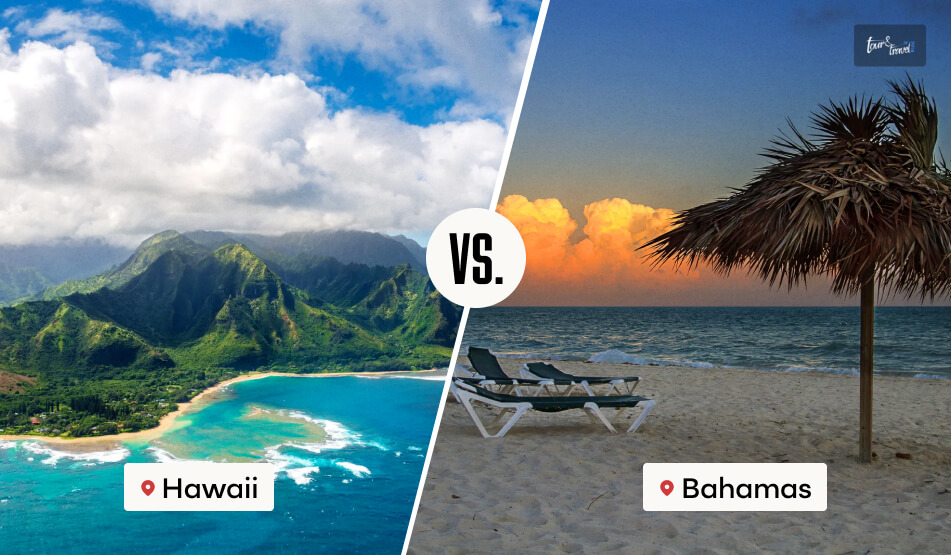
The Bahamas and Hawaii! Two beautiful tropical destinations with beautiful beaches and natural abundance. But which one is better as a vacation spot?
We will examine all aspects in this Hawaii vs. Bahamas comparison. And let’s begin with a brief understanding of the tourism landscape in both locations.
2024 was a great year for the Bahamas tourism industry. 11.22 million international tourists visited the country in 2024.
However, it has also been a challenging year for the country’s tourism ecosystem, with the crime rate going up and various countries issuing advisories about the need for taking increased caution during a trip to the Bahamas.
On the other hand, Hawaii, the USA, welcomed 770,940 visitors in 2024, and the visitor spending in the same year was $1.55 billion.
So, 5000 miles apart from each other, the Bahamas and Hawaii are both growing massively as world-class tropical vacation spots.
However, if you want detailed insights about Hawaii and the Bahamas as vacation spots and which one is better, you will have to read our Tour and Travel Blog.
How To Reach Hawaii Vs Bahamas From The USA?
If you are in the USA, you don’t need a passport or visa to travel to Hawaii. However, for a trip to the Bahamas, you will need a valid USA passport.
You don’t need a visa, though, if you are visiting the Bahamas from the USA as a tourist.
Reaching Hawaii
Hawaii has the Daniel K. Inouye International Airport. So, it is well connected to the other parts of the USA through flights.
You will especially get multiple flights from California and Los Angeles to Hawaii.
Also, once you reach Hawaii, you will get various cheap flights operated by Southwest Airlines and Hawaiian Airlines to hop between the Hawaiian islands.
Reaching The Bahamas
Though the Bahamas is not a part of the USA, the distance between the states on the west coast of the USA and the Bahamas is almost the same as their distance from Hawaii.
In fact, flight charges from these states to the Bahamas are often less than the price of flight tickets to Hawaii.
Hawaii Vs Bahamas: Quick Facts
Comparison
The Bahamas
Hawaii
Size
13,880 km²
11,672 km2
Population
403,033
1450900
Capital
Nassau
Honolulu
Airport
Lynden Pindling International Airport Grand Bahama Freeport
Daniel K. Inouye International Airport
What Is The Best Time To Visit Hawaii Vs Bahamas?
Despite being popular tropical destinations and sharing almost the same distance from the Equator, there are some differences in the weather conditions of Hawaii and the Bahamas.
The shoulder seasons of spring and autumn are the best times to visit Hawaii. So, you can plan a trip to Hawaii during April and May or September and October.
During April and May, the average temperature in Hawaii hovers around 20 degrees Celsius. On the other hand, the average temperature during September and October remains close to 25 degrees Celsius.
On the other hand, mid-December to mid-April is the ideal time to visit the Bahamas. During these months, the temperature in the Bahamas remains between 22 and 24 degrees Celsius.
Weather Conditions In Hawaii Vs Bahamas
With a predominantly tropical climate, Hawaii experiences a diverse range of weather conditions.
It features volcanic mountains, including Powers Caldera, Mauna Kea, and Mauna Loa, among others. Mauna Loa is the tallest among them, with a height of 4205 meters.
So, you will experience a change in temperature and weather conditions in those mountains. Also, there will be natural calamities such as blizzards and thunderstorms.
On the other hand, the Bahamas has a relatively seamless temperature scenario throughout the year.
However, there is heavy rainfall in October, and hurricanes are frequent in the Bahamas from September to November.
Bahamas Or Hawaii For Family Vacation: Which One Is Safer?
The Bahamas and Hawaii are excellent choices for tropical getaways. However, Hawaii has more seamless weather conditions throughout the year.
So, it can be a more suitable destination for family vacations. But which one is safer for a family vacation? Let’s find out!
Is The Bahamas Safe?
Also, there is a major concern about “is the Bahamas safe?”. The year 2024 has seen a sharp rise in the crime rate in the Bahamas. The Bahamas’ murder rate in 2024 was 29.7, which was 8% more than in 2023.
Moreover, the U.S. Travel Advisory, the Canadian Bahamas Travel Advice, and the “Foreign Travel Advice Bahamas” issued by the UK Government advise tourists to exercise increased caution during their trip to the Bahamas.
There are even guidelines to avoid visiting various areas of Nassau and Freeport. In addition, all the advisories mention security threats such as violent crimes, sexual assaults, robbery, the unregulated boating industry, and increasing shark attacks in the Bahamas.
So, if you want to plan a family trip to the Bahamas right now, it’s not the best time.
Is Hawaii Safe?
Currently, Hawaii is safer, as evidenced by the 2025 Violent Crimes Comparison from the Honolulu Police, which shows improvements in crime records.
First of all, there has been a remarkable improvement in forcible sex offenses. In 2025 so far, the forcible sexual assault cases recorded are 159, and in 2024, the recorded sexual assaults for the same time period were 230.
Again, the number of murders and non-negligent manslaughter has gone down to 1 in 2025 from 11 in 2024.
Also, the aggravated assault cases have gone down to 247 in 2025 from 254 in 2024. However, the number of robbery cases has slightly increased, with 128 cases reported so far in 2025, compared to 127 cases during the same period in 2024.
So, Hawaii is now safer than the Bahamas when planning a family vacation.
Where To Stay In Hawaii Vs Bahamas?
Hawaii and the Bahamas are both known for their luxury hotel and resort experiences. Further, some really big names offer their hospitality services in these locations.
Luxury Hotels To Stay In The Bahamas
Luxury Hotels To Stay In Hawaii
Grand Hyatt Baha Mar Atlantis Hilton at Resorts World Bimini Holiday Inn Express & Suites Nassau
Hilton Hawaiian Village Waikiki Beach Resort Hyatt Centric Waikiki Beach The Laylow, Autograph Collection Holiday Inn Express Waikiki
Hawaii Vs Bahamas: It’s All About The Experience
From Oahu, the best Hawaii island to visit, to Paradise Island in the Bahamas, there is no dearth of attractions for tourists in these locations.
So, we have done a Hawaii vs Bahamas comparison based on three factors: luxury accommodation, food scenes, and the places to visit.
Hawaii Vs Bahamas Luxury Accommodation
You already know that many luxury hotel brands have their presence in the Bahamas and Hawaii.
Also, for a more opulent experience, you can choose luxury resorts with private beaches in both locations.
Overall, in terms of elegance, comfort, and convenience, both places score equally in luxury accommodations.
Hawaii Vs Bahamas Food Scenes
You will fall in love with local delicacies such as Garlic Shrimp and Kalua Pork in Hawaii. For the most authentic culinary experience, you must choose the local eateries.
These eateries offer the best of local flavors at affordable prices. So, you can use your money to engage in more adventurous activities in Hawaii.
The Bahamas, on the other hand, allows you to taste the best Conch Fritters and Plantain Fries. Here, too, you can opt for local eateries instead of high-end dining places for the ultimate Bahamian delight.
Hawaii Vs Bahamas Tourist Attractions/Places To Visit
Some top tourist attractions in Hawaii include Pearl Harbor National Memorial, Waimea Canyon State Park, the USS Arizona Memorial, Iolani Palace, Waikiki Beach, and Oahu Beach, among others.
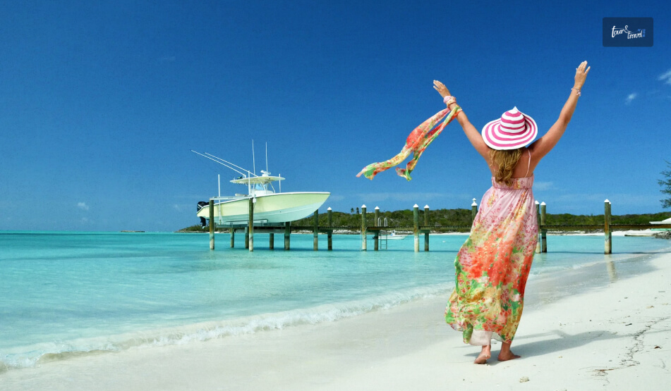
The best places to visit in the Bahamas are Paradise Island, Nassau, Exuma Cays, Harbour Island, Bimini Islands, and Freeport.
Is Hawaii Or Bahamas Cheaper? Setting Your Budget Right
The Bahamian Dollar, or the Bahamian currency, now has an exchange rate of 1=0.99 USD. Therefore, there will be little to no difference in travel costs between these two places.
In fact, the rates of flights from many parts of the United States to the Bahamas are cheaper than those to Hawaii.
However, the public transportation system in Hawaii is more developed than that in the Bahamas.
Additionally, Hawaii offers a wider range of accommodations at various price points than the Bahamas.
On average, a trip to the Bahamas will cost around $760, while a trip to Hawaii will cost approximately $670.
And The Winner Is…
Now, this is tough! The Hawaii vs Bahamas comparison as vacation spots has once again shown that both places are great tropical destinations.
Further, both places boast a wonderful fusion of history and natural beauty. Also, both places are ideal for culinary tourism.
However, a trip to Hawaii will be a little less costly as the accommodation options are diverse. Moreover, the rising crime rate in the Bahamas is a serious concern.
So, solely based on the safety parameter, Hawaii is a better vacation spot for now!
Sibashree is a travel, culture, and leisure writer who has been writing since the age of 12 and professionally since 2014. With more than a decade of travel writing experience and journeys across India and several parts of the world, she brings a deeply personal and thoughtful perspective to her work. A student of English Literature and Mass Communication, Sibashree has always viewed travel as more than movement — for her, it has been a way of understanding people, cultures, and herself. Her passion for spiritual exploration has also led her to many unusual and meaningful destinations over the years. Outside of writing, Sibashree enjoys watching European cinema, reading about global politics, and reflecting on the stories hidden within everyday places.
Fishing transcends mere recreation; it's a doorway to nature's beauty and cultural immersion.
Picture yourself amidst stunning landscapes, casting your line into shimmering waters as you feel the gentle tug of a potential catch. Whether you're an angling aficionado or a novice eager for adventure, this comprehensive guide is your compass to curating an unforgettable fishing trip during your travels.
Choosing the Ideal Fishing Destination
Selecting the right fishing spot lays the foundation for a memorable journey. Beyond merely seeking a productive location, consider destinations that offer a complete experience. For instance, Key West fishing charters present a picturesque setting blending abundant fish varieties with the vibrant local culture. Whether you prefer freshwater lakes, coastal bays, or deep-sea adventures, understanding the nuances of each location ensures a fulfilling experience.
Preparing for the Adventure
Packing for a fishing expedition demands meticulous planning. Aside from the essential fishing gear—rods, reels, lines, and tackle boxes—ensure you're equipped with suitable attire, sunscreen, and ample hydration. Equally crucial is familiarizing yourself with local regulations and guidelines governing fishing activities. Acquiring the necessary permits or licenses and understanding catch limits prevent any unwanted setbacks during your trip.
Techniques for Successful Fishing
Mastering fishing techniques is a blend of art and science. Beginners might start with fundamental casting methods and basic bait presentation. As proficiency grows, exploring advanced techniques like fly fishing or trolling allows anglers to target specific species more effectively. Understanding the nuances of each method significantly enhances the likelihood of a successful catch, adding to the thrill of the experience.
Immersing in the Experience
Beyond the thrill of reeling in a catch lies a deeper connection with the environment and local culture. Engaging with the surroundings, appreciating nature's serenity, and immersing yourself in the local fishing traditions enriches the experience. Embracing sustainable fishing practices, such as catch-and-release, not only preserves the ecosystem but also fosters a profound respect for marine life and its conservation.
Capturing the Moment
Preserving the essence of your fishing journey extends beyond the memories. Through photography, storytelling, or journaling, you immortalize these moments. Share your adventures on social media platforms, compile them into a personalized travelogue, or simply cherish them as a testament to the enriching experience. Reflecting on these memories heightens the impact of the journey, fostering a deeper appreciation for the adventure you've embarked upon.
Conclusion
In summary, embarking on a fishing expedition while traveling transcends the act of catching fish; it's about embracing a holistic experience. From meticulously selecting an ideal destination like Key West fishing charters to meticulous preparation, mastering fishing techniques, immersing in nature and culture, and capturing indelible memories, each facet intertwines to create an unforgettable journey. So, pack your gear, set sail, and let the waters guide you towards an adventure that's more than just a fishing trip—it's a soul-enriching escapade.
Read Also:
Six Important Factors To Consider Before Planning Alaska Fishing Trip
10 Best Fishing Charters In Florida To Visit In 2022 – Tour And Travel Guide
Unforgettable Island Adventures: Things To Do In Tenerife
If you’re searching for family-oriented natural wonders and mouthwatering dishes, Pigeon Forge is an ideal selection for your forthcoming vacation. Nestled in the foothills of the glorious Great Smoky Mountains in Tennessee, Pigeon Forge offers a trove of experiential treasures awaiting your exploration, from embarking upon exhilarating activities to indulging in delightful shopping and relishing the mouthwatering offerings at various dining spots.
Whether you're in the mood for a scenic drive along picturesque mountains or yearning to immerse yourself in the genuine warmth of local eateries, this charming mountain town promises an unforgettable escapade that will create a lasting memory.
Pigeon Forge attracts millions of recreational visitors yearly since the place has something to offer for every travel enthusiast. If you’re looking to experience the best of this mountain town, you’ve come to the right place.
Here Are Six Prime Ideas For Experiencing The Best Of Pigeon Forge
Below, we’ll share some valuable tips to make your Pigeon Forge trip memorable:
1. Experience the Comedy Barn
The Comedy Barn Theater in Pigeon Forge is a must-visit place, especially for families with kids. If you’re looking for a fun time to enjoy comedians, ventriloquists, barnyard animals, jugglers, and live country and gospel music, The Comedy Barn will surely live up to your expectations. Running for over 25 years, it’s one of the most attended and successful shows. What’s best is that you can even join in on the action and become part of the show.
So, bring your kids and family for a fun night of theatrical comedy at The Comedy Barn, and make the most of your Pigeon Forge vacation.
2. Explore Dollywood
You might have to plan an entire day of your schedule if you wish to visit Dollywood. Whether you’re looking to boost your adrenaline or seeking some thrill, this park offers various heart-pounding rides along with scenic views of the Smoky Mountains. From delicious home-cooked treats to strumming banjos, this theme park will have you coming for more. What’s best is that it’s perfect for visitors of all ages.
So, the next time you’re in Pigeon Forge, TN, don’t forget to add Dollywood to your must-visit list. It’s also an ideal spot for those who don’t want to splurge too much on their vacation.
3. Bask in the Great Smoky Mountains
When in Pigeon Forge, don’t forget to plan trekking or hiking in the majestic Smoky Mountains. The mountains present a plethora of outdoor pursuits, including hiking, camping, angling, wildlife spotting, and a myriad of other engagements to satiate the nature enthusiast.
Exploring the Great Smoky Mountains is genuinely enriching when you embark on a guided expedition led by knowledgeable locals. Who can provide valuable insight into the natural history of the region better than the locals? Amid the many choices, a favored endeavor is an excursion into the tumultuous currents via whitewater rafting, where you traverse the untamed rivers and streams within the park's confines. Whether you're looking for adventure or want to relax amid nature, the Great Smoky Mountains National Park offers a distinctive allure that resonates with diverse visitors.
4. Buy Attraction Tickets Online
For tourist attractions, amusement parks, and other renowned activities in Pigeon Forge, there can be significant savings by purchasing your tickets online before arriving. Many of the city's major attraction websites offer discounts for pre-purchasing online that save substantial amounts from their regular gate prices. Shopping around for these bargains ahead of time is a great way to get more out of your vacation budget.
Moreover, some online retailers offer additional discounts for bundled packages that combine multiple attractions into a single purchase at an even better rate. It pays to research and take advantage of these offers when possible, as you could save hundreds or thousands of dollars on tickets alone.
5. Try Famous Pancakes
You haven't experienced Pigeon Forge completely until you've tasted the popular pancakes. This delicious delicacy is eminent across the city and served at probably the best restaurants around. Whether you select classic buttermilk pancakes or something more intriguing like blackberry and cream cheese crepes, there's a different delightful flavor to choose from.
Most pancake joints serve fresh-cut fruit and other mouthwatering sides to accompany your meal, making it an extraordinary method for starting your day before going out for outdoor adventures.
Apart from pancakes, Pigeon Forge boasts other gastronomic delights you must try whenever visiting this mountain town. Southern barbeque, moonshine, fresh rainbow trout, homemade maple syrup, and many other options are available to satisfy your food cravings in Pigeon Forge.
6. Stay in the Luxury Cabins
Book one of the city's extravagant cabins when you're ready to rest your head after a long day of exploring. While lodging rooms are accessible in Pigeon Forge, they don't offer a similar level of solace as a lavish cabin. Whether you select normal or deluxe accommodations, they offer extraordinary conveniences and features that will make your visit memorable.
From comfortable fireplaces to rich furniture and hot tubs, these lodges offer a level of luxury that you won't find elsewhere in the city. Also, many of them come with stunning mountain views that make for unforgettable experiences throughout your visit. It does not require mention that they come equipped with fully furnished kitchens. It allows you to save money on your vacation by cooking dinner in the convenience of your own cabin.
Conclusion
Pigeon Forge is a tourist-loved, popular spot to discover, explore, and gain experiences that will last a lifetime. Whether you’re going for business, to immerse in nature, or to unwind, Pigeon Forge offers something uniquely amazing for everyone. With countless fascinating activities, attractions, and destinations to see – you’ll never be exhausted in Pigeon Forge.
Visiting the famous comedy theater will prove worthwhile if you’re looking for fun and laughter. If you follow these tips for experiencing the best of Pigeon Forge, you will surely make unforgettable memories and fun stories to share with your family and friends. So, pack your bags and prepare for a delightful experience full of crisp mountain air and loads of fantastic discoveries.
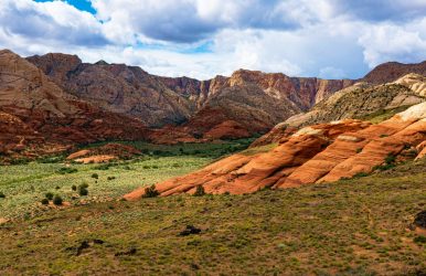
What are some of the best things to do in St. George, Utah? There are countless outdoor activities and breathtaking scenery all around in this adventurer's paradise!
Situated amidst the magnificent red rocks of southern Utah, St. George is renowned for offering distinctive experiences that appeal to individuals searching for natural marvels and an exhilarating vacation.
Allow us to walk you through some of the best St. George activities to ensure that your trip, whether from Las Vegas or somewhere else entirely, is truly unforgettable.
Take in the breathtaking vistas while hiking in Zion National Park or exploring Red Cliffs National Conservation Area. Visit the Little Black Mountain Petroglyph Site to get a firsthand look at historical sites. Some of the top outdoor activities in St. George, Utah, are listed below for your enjoyment.
List of Outdoor and Nature Parks
Dixie Rock
St George Narrows
Pioneer Park Arches
Snow Canyon State Park
Quail Creek State Park
Butterfly Hike- Lava Tubes
Jenny's Canyon
Petroglyph Slot Canyon
Red Hills Desert
Little Black Mountain Petroglyphs
St George Hot Air Balloon Rides
Sand Hollow State Park
Yant Flat (Candy Cliffs)
Top List of Arts and Culture Venues in St George
Pioneer Courthouse
St George Utah Temple
Kayenta Art Village
Jacob Hamblin Home
Daughters Of Utah Pioneer Museum
Tuacahn Centre For the Arts
Brigham Young Winter Home Historical Site
Green Gate Village
St George Tabernacle
St George City Art Museum
Western Sky Aviation Warbird Museum
Explore The Historic Downtown
List of Fun Things to Do in St George Utah, for Family and Kids
St George Carousel
St George Dinosaur Discovery Site
Thunder Junction Park
Parks and Playgrounds
Silver Reef Ghost Town
List of Food and Drink Places
Beers at Zion Brewery
Dessert at Nielsen’s Frozen Custard
Drive in at Larsen’s Frostop
Dinner at Chef Alfredo’s
Things To Do in St George Utah
Grab a water bottle and put on your adventure hat, and let's explore what this quaint city has in store for you! You will find a lot of unusual things to do in St George Utah.
Zion National Park
Zion National Park is one of the must-see locations close to St. George. Moreover, it has some of Utah's most breathtaking scenery and hiking paths. The park is a great place to get away from the lights of the city because it has 15 miles of horseback riding trails and 38 miles of hiking trails.
The Narrows hike, a unique experience through a slot canyon that provides breathtaking views while wading through the Virgin River, is undoubtedly the most well-known hike in Zion.
Beginning at the Temple of Sinawava, this amazing trail descends into canyons with imposing walls that rise to a height of a thousand feet on either side.
If you're up for an additional challenge while visiting, then think about hiking Angels Landing, a famous trail with breathtaking views but with treacherous switchbacks and exposed cliffs along the way.
While you're enjoying Zion National Park, don't forget to compile a Utah bucket list that includes other interesting places that are accessible by car from St. George and are great for families!
You won't be disappointed by all that this amazing area has in store for you, from exploring neighboring Sand Hollow State Park with its skydiving and ATV rentals to visiting other breathtaking parks like Bryce Canyon or Arches National Parks!
Red Cliffs National Conservation Area
Your journey from Las Vegas to St. George will be made even more memorable by the exploration of the magnificent Red Cliffs National Conservation Area. It is a vast 45,000-acre area in the heart of Washington County, Utah.
This area is nothing short of spectacular, thus making it a must-visit gem for outdoor enthusiasts seeking exhilarating activities in St. George or simply looking for an escape into nature's wonders.
The Red Cliffs National Conservation Area boasts breathtaking scenery with a variety of wildlife that adds to its allure, as well as distinctive red rock formations found within the Red Cliffs Desert Reserve.
It's highly recommended that you get a trail map and head out on one of the many designated trails. You can see the breathtaking waterfalls as well as expansive vistas that are unique to St George.
It makes sense that everyone's top priority when visiting this area is to explore Red Cliffs, with so much natural beauty right at your fingertips.
Little Black Mountain Petroglyph Site
The Little Black Mountain Petroglyph Site is a must-see location in St. George. Visitors can get a glimpse of the rich history and culture of the area by viewing the ancient petroglyphs carved into sandstone boulders at this site.
Moreover, all ages as well as skill levels can enjoy the short, easy hike around the site.
There are no restrooms close to the Little Black Mountain Petroglyph Site, so bring plenty of water and wear comfortable shoes. It's fascinating to take your time walking around and taking in all the fine details on each rock carving!
Visitors can enjoy outdoor activities like hiking around St. George or climbing Dixie Rock at Pioneer Park, both of which are well-known destinations in and of themselves, in addition to exploring this historic gem!
St. George Historic Downtown
As travel enthusiasts, we urge you to stop by St. George Historic Downtown while you're in Utah. Your trip will be made unforgettable by the history, culture, as well as mouthwatering culinary options found here.
The St. George Tabernacle, a distinctive historical site with an intriguing past that is sure to captivate history buffs and casual visitors alike, is one of the top-rated attractions here.
Pioneer Park, which is perched high above downtown and provides breathtaking views of the city, is another fantastic location in St. George's downtown. It's the ideal location for a quiet family outing or a quiet place to spend some time alone while admiring the surrounding natural beauty.
After exploring the historic downtown, if you're looking for even more nearby activities, don't miss the Brigham Young Winter Home Historical Site or Red Hills Desert Garden, which are both conveniently close by!
Western Sky Aviation Warbird Museum
The Western Sky Aviation Warbird Museum is one of our top recommendations for attractions in St. George, Utah. So, you won't want to miss this exceptional aviation museum with its sizable collection of vintage aircraft.
You can see these amazing machines up close as well as discover more about how our pilots operate them.
Apart from witnessing the aircraft, you can also watch actual fossils being prepared in their laboratory! Visitors can observe experts working on dinosaur bones as well as other ancient specimens in a real fossil prep lab located inside this museum. Hence, observing how they are handling these precious relics firsthand is fascinating!
When in the area, make sure to visit the Western Sky Aviation Warbird Museum, which is regarded as one of the Best Things to Do in St. George, Utah. If you would rather explore on your own, then the museum also provides self-guided tours and guided tours led by knowledgeable tour guides.
Red Hills Desert Garden
The Red Hills Desert Garden in St. George, Utah is one of our favorite places to visit. Situated on Red Hills Parkway, this botanical garden provides sweeping views of the city. Moreover, it is close to Pioneer Park.
Built on top of Dixie's red rocks, this location boasts a unique desert landscape that cannot be found anywhere else, which is what makes it so special.
The public can enter the garden for free, hence making it a cost-effective way to spend a day in St. George. A man-made stream meandering through the park provides a soothing sound as you stroll along paths bordered with native plants.
Moreover, the Virgin River provides the water, which heightens the tranquil atmosphere this urban oasis creates.
A day trip to St. George is a great idea if you're looking for something different and serene to include in your Las Vegas itinerary. Moreover, make sure to visit Red Hills Desert Garden alone.
St. George Dinosaur Discovery Site
During your trip to Utah, visit the St. George Dinosaur Discovery Site at Johnson Farm. It is bound to be an incredible experience! Thousands of dinosaur footprints are preserved in this museum at the exact location where they were found.
Discover unique fossils as well as dinosaur exhibits that will excite any history buff as you explore the museum. Even more thrilling is the fact that guests can use their hands to unearth replica fossils!
The location is renowned for its remarkable array of preserved dinosaur footprints from various taxa, such as ornithopods, theropods, as well as sauropods.
During an interactive tour, the guides provided us with astonishing information about these creatures that ruled our planet millions of years ago.
Overall, this hidden gem in southern Utah is genuinely unique. So, if you're considering a weekend trip to St. George, then make sure not to miss it!
Vortex Hike
If you only do one in the vicinity of St. George, then we suggest the Vortex hike as a unique hike. The entire hike is amazing, in addition to the Vortex itself being incredible.
While it's very busy and well-liked on weekends, we only saw one other group as we were leaving during our midweek visit. This is a moderate hike that takes about one or one and a half hours to complete (not including the time you want to hang out there). It is about 2.16 miles round trip.
Remember that the final five miles will be on unpaved roads. When we went, there were some muddy and dubious areas on the road because it had just snowed.
Although four-wheel drive as well as high clearance are always helpful, we also noticed a minivan in the parking lot.
When trying to take pictures of the Vortex, the sun's position is a major factor. To prevent harsh shadows on the rock feature, you should be there either at dawn, dusk, or midday when the sun is at its highest. On a cloudy day, any time is acceptable.
Given that some of the cairns were difficult to locate, we strongly advise obtaining an offline map for the trail. Get the maps by downloading an app, and you won't have to worry about getting lost.
Scout Cave
If you have limited afternoon time when visiting Snow Canyon State Park, then trek to Jenny's Canyon and Scout Cave.
The hike wasn't too interesting, but Scout Cave was lovely. Moreover, Jenny's Canyon is an easy 10-minute stop with a short approach.
This state park is remarkably close to the city. It is also just ten minutes away. After speaking with a few locals, we learned that because people are so intent on seeing Zion, they frequently overlook it.
Next, when we have more time, we'd like to spend a whole day exploring the remaining portion of the park.
We would have given ourselves a whole day to explore the remainder of the park if we had known better. Because Snow Canyon offers an abundance of hiking opportunities.
Scout Cave appears far better in the morning light than it does in the afternoon or evening. This is definitely one of the many fun things to do in St George Utah.
Getting To St George: Driving
For those who want to take their time exploring Utah's breathtaking natural scenery, driving from Las Vegas to St. George, UT, is a popular choice. So, the trip is usually completed in two hours and travels about 120 miles.
One option is to pick up a car at the airport in Las Vegas and then head directly to southern Utah.
You get a preview of what's to come as you get closer to St. George, where the scenery changes to towering red rock formations and sandstone cliffs.
It's crucial to keep in mind that the route between Las Vegas and St. George can occasionally get very solitary. So be ready with extra water, gas, and food in case there are any unforeseen delays or detours.
But the ride itself is very scenic, with gorgeous views of neighboring state parks like Valley of Fire and charming little towns along the way.
If you don't feel like driving, then there are lots of tours that can handle all your transportation requirements. Moreover, they offer enlightening commentary on the natural wonders and history of the St. George area.
Take A Tour
So, there are numerous tours available for visitors who want to explore St. George while they are in Las Vegas. Taking a guided tour with one of the many companies based in Las Vegas, such as Pink Jeep Tours and Grand Canyon Tour Company, is one option.
These tours usually take you along picturesque routes so you can enjoy the scenery as you travel between the two cities.
Therefore, there is sure to be something exciting waiting for every visitor interested in seeing everything that St. George has to offer, with a variety of options available, from gentle sightseeing trips appropriate for all ages to hardcore expeditions for experienced enthusiasts ready for rougher terrains!
Wrapping Up
To sum up, if you're searching for unique experiences as well as outdoor adventures, then St. George, Utah, is a great place to visit.
Also, this city offers activities for all kinds of visitors, from hiking in Zion National Park to visiting the Western Sky Aviation Warbird Museum. A variety of activities are available for visitors to enjoy, such as exploring the Little Black Mountain Petroglyph Site and kayaking at Sand Hollow State Park.
Read Also:
Best 9 Things To Do In El Paso!
Here Are The 10 Best Things To Do In Baltimore!
Roman Revelations: Unforgettable Things To Do In Rome, The Heart Of Italy!


 Related