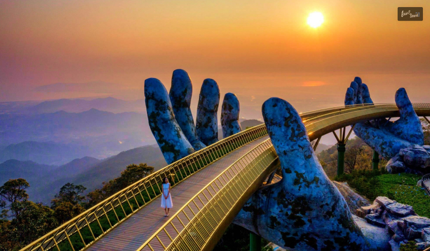
Are you one of those who loves taking stunning photographs of monuments worldwide? The Golden Hand Bridge is one of the striking monuments that can give you the perfect backdrop for your picture or a wallpaper-worthy photo.
The Golden Hand Bridge in Vietnam is an attraction in a themed park that was recently added to the list of beautiful places worldwide. The bridge’s construction started in July 2017 and was completed in April 2018.
A stunning and unique architectural wonder, Golden Hand Bridge deserves all the attention and popularity it is getting! It is beautifully located in the Ba Na Hills Amusement Park in one of the major cities, Da Nang, in Vietnam. The attraction has become viral due to social media platforms!
In this article, I am writing about how walking on the Golden Hand Bridge in Vietnam feels! It is like walking on sunshine as the environment adds up to the beauty of the bridge!
Walking On Sunshine: Exploring The Magic Of Vietnam’s Golden Hand Bridge!
The amusement park in which the Hand Bridge has been built is a Disney-style theme park known as Ba Na Hills. Hand bridge is another common name for the Golden Bridge! You can see it all over social media as people visit the place and create beautiful pictures.
If you want to visit the Golden Bridge Vietnam, you can take a guided tour of the Ba Na Hills from Hoi An or Da Nang! Along with the bridge, other things are included in the guide, such as Fantasy Park, the French Village, and the Cable car ride.
The whole trip will take at least 3 hours to cover! If you are taking a car ride from the city, it will take some time. You will have to pay 750000 dong to visit the bridge, which might seem more expensive for some, especially if the weather is overcast!
You still have to visit the bridge because it is one of a kind!
Costs Of Tickets To Visit Golden Bridge Da Nang!
You do not have to pay any money to visit the bridge. However, the Ba Na Hills Resorts owns the Golden Bridge Da Nang Bridge. The bridge is included in the Sun World Ba Na Hills tourism complex, so the rate of visiting the resort is included in the ticket price for the cable car.
You have to reach the resort by car while reaching the hilltop of Ba Na Hills by cable car. The ticket price for adults for a round-trip is $38.30! You can visit the bridge in two seasons, extending from April to September and October to December.
For children whose height is between 1m and 1.4m, the round-trip tickets cost around $31.01! Children below that height can visit where their parents do not need to buy any tickets. There are also offers with a lunch buffet and combo cable car tickets priced around USD $46.38.
About Golden Bridge Da Nang!
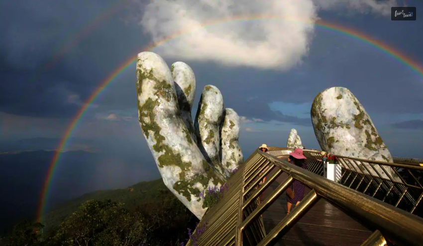
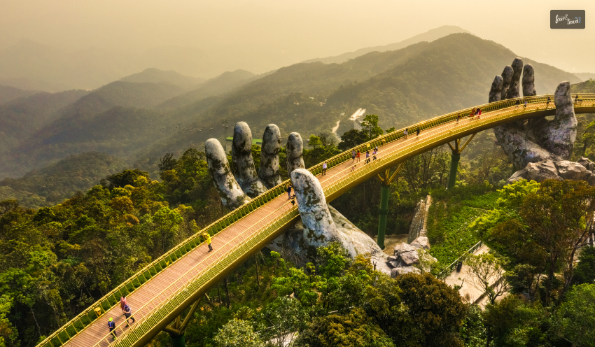
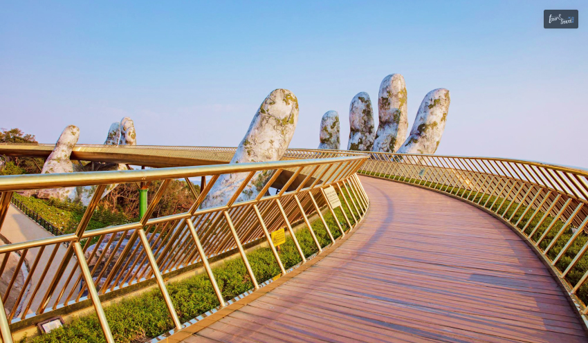
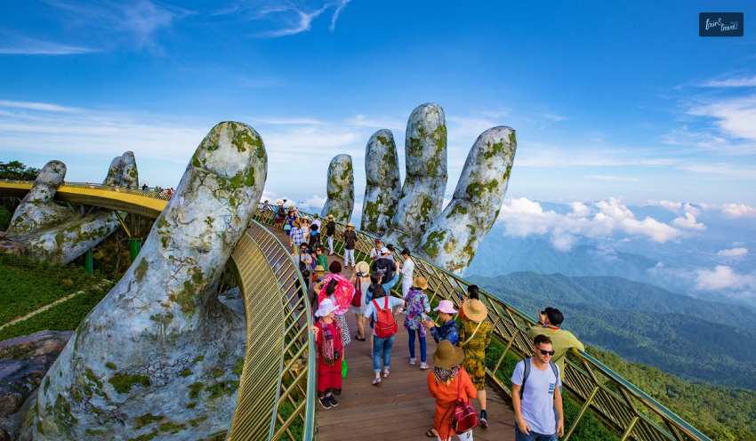
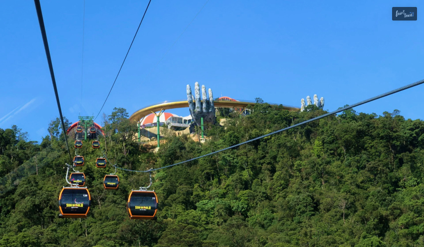
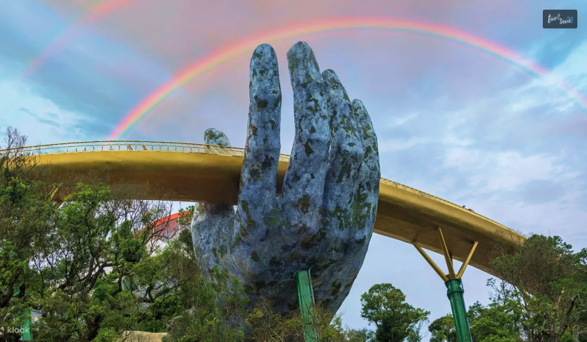
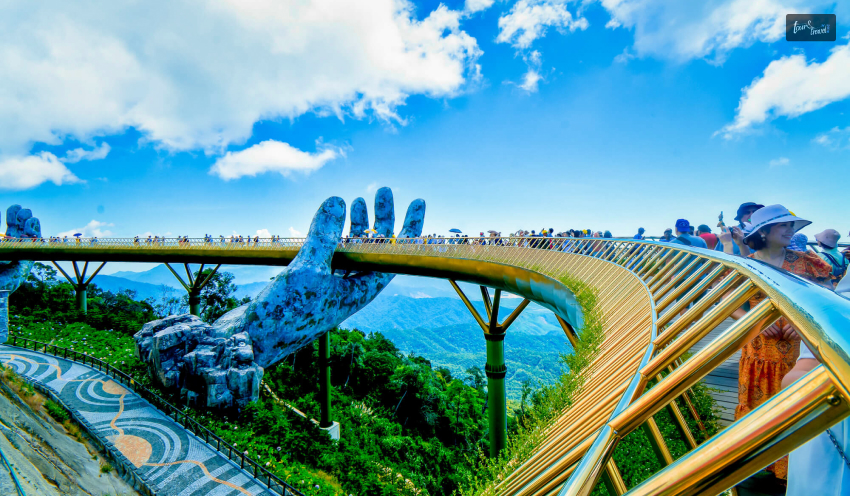
One of the most photographed spots located within Ba Na Hills, Golden Bridge Da Nang is a 500-foot-long bridge with railings shining in golden color. The bridge has been constructed with such a design that it is cradled between two colossal hands.
The hands are so big that they seem to be up in the clouds. Further, during rainy days, the clouds are covering the hands. The bridge is 12.8m wide with eight arches. The concept of the bridge was about walking across the hands of the God of mountains on the clouds.
The Hand Bridge in Vietnam acts as a connector between the cable car station, which is located at the hilltop, and the Paradise Gardens. Further, the bridge gives you a perfect view of the Annamitr Mountains and the East Sea.
I suggest you arrive early in the morning if you want an excellent picture of the attraction or get a photo of yourself on the bridge. When visiting the bridge, you can also cover fantasy parks, the French village, and a cable car ride, making it a complete circle!
How To Reach The Golden Bridge In Vietnam?
To reach the Golden Hands Bridge Vietnam from Da Nang City, you must go to Sun World Ba Na Hills first. You can go from Thien Thai Flower Garden or Marseille station to the Golden Hand Bridge. There are different transportation routes which you can take!
Car Rental In Da Nang
You can rent a car in Da Nang to travel to the bridge, especially with people ranging from 4 to 45 people. The rental vehicle is both cost-saving and flexible. The round trip ranges from somewhere $17.02 to $93.62.
Taxi
If you are looking for something reasonable, book a taxi if you are in a group of 4 to 7 people. The price of a round-trip taxi visit starts from $21.28 to $25.53.
Bus To Ba Na
If your budget is cheap, take a bus from Da Nang, which will take you to Ba Na in just 75 minutes. The bus is specifically for tourists, and the round-trip costs $6.38 per head. However, the timing could be more relaxed as tourists are picked up between 7:30 and 8:30 from Da Nang.
While returning, tourists are picked up from Ba Na between 14:30 and 15:30 to return once the Bridge tour is done. For tourists, it can be restrictive at times!
Transfer Car From Danang To Ba Na
The transfer car starts from 72 Nguyen Chi Thanh and takes tourists to Ba Na Hills, with the round-trip ticket costing around $2.98 per head. This transportation is convenient for visitors planning to visit Ba Na in the morning, but there will be issues for evening visitors!
Again, with the pocket-friendly rate, the car is restricted concerning the timing of the transfer car, which only functions between 8:30 in the morning and 18:00!
Motorbike Rental
If you are young and know how to ride a motorbike or your partner knows, go for the motorbike rental! It is one of the best choices for tourists because it creates opportunities for you to enjoy nature and its beauty.
This transportation choice lets you stay the most active concerning your travel plans. The motorbike rental price ranges from $4.26 to $6.38 per head.
What Is The Best Time To Visit The Golden Bridge Da Nang?
What is the perfect time to visit Golden Hand Bridge in Vietnam? The opening hours of the bridge start at 8:00 AM, while it closes at 18:30. Considering it is one of the recent and popular attractions on social media, there is a huge crowd.
You must know the crowded time while visiting the bridge is between 9 AM and 17:00. So, if you plan to visit the bridge to avoid the rush or the crowd, you must visit either before 9 AM or after 17:00 PM.
You can experience four seasons, namely summer, winter, spring, and autumn when you go to the bridge. The cool atmosphere you enjoy up on the bridge is amazing, along with the beautiful scenery.
When taking pictures of the attraction, you have to include one of the hands in your photo! It looks majestic! Along with that, you can also opt for panoramic photos. Either simulate the hand or stand inside it to show the magnificent perspective of it.
Places To Visit While On the Golden Hand Tour!
Based on my understanding of other people’s experience of the place, you can visit the place either in the morning or afternoon. If you are hoping for foggy pictures or with the sun rising high on the clouds, go in the morning!
Sometimes, you can also catch birds flying, which is a beautiful visual! However, if you are looking for more light, glowing sun in your pictures, you can go in the afternoon. The sunset is just perfect in the afternoon, with a romantic vibe.
If you are visiting with your partner, it is the perfect time to go, especially when the photographs will be to die for! Apart from the Golden Hand Bridge, remember that there are other places to visit, such as an amusement park called the Fantasy Park.
How can you remember the restaurants and cafes that are of different styles? You have to try the delicious food and beverages there. Further, you gotta visit the Ling Ung Pagoda and the flower gardens.
Weather Must Be Taken Into Consideration!
Image Source : images.rove.me/
The Golden Hand Bridge has been constructed to be up in the clouds. It is, therefore, important to consider the weather when visiting the Golden Hand Bridge.
According to a review on Tripadvisor by udontnomee3e, an overcast day is a bad day to visit the bridge! If the weather is rainy, cold, and cloudy, there is a high chance that you will not be able to enjoy the attraction or take good pictures.
The issue, however, with it is that you cannot know what the weather will be when you go up from below because the weather is completely different! During bad weather, the visibility becomes terrible, and the steps become slippery.
It isn’t obvious because when you are on the ground, you will not realize the weather status on the bridge. At the top, it might be completely different!
Highlight Of The Golden Hand Bridge!
Image Source: d13jio720g7qcs.cloudfront.net
The bridge has hosted a fashion show called “A Walk on a Cloud” fashion by the Fashion Voyage. It is a groundbreaking achievement, especially with the spectacular natural view and a harmonious blend of architecture.
The bridge has inspired many designers from the fashion industry to create something that represents out-of-the-world structure. Many couples have done their wedding photo shoots, especially if the location has been accessible.
Even though it looks artificial, the bridge is quite interesting in becoming a worldwide photography sensation. It is nothing close to Disneyland, but the amusement park in which it has been made has created quite a stir and an awareness!
Accommodation At Ba Na Hills!
If you are planning to stay at Ba Na Hills, consider the tour of the Golden Hand Bridge, which can be completed in less than one day! There are other features and attractions that you have to complete, and then you have to book your accommodations there.
Some of the best hotels or resorts that you can book while on a trip to the Golden Hand Bridge are as follows:
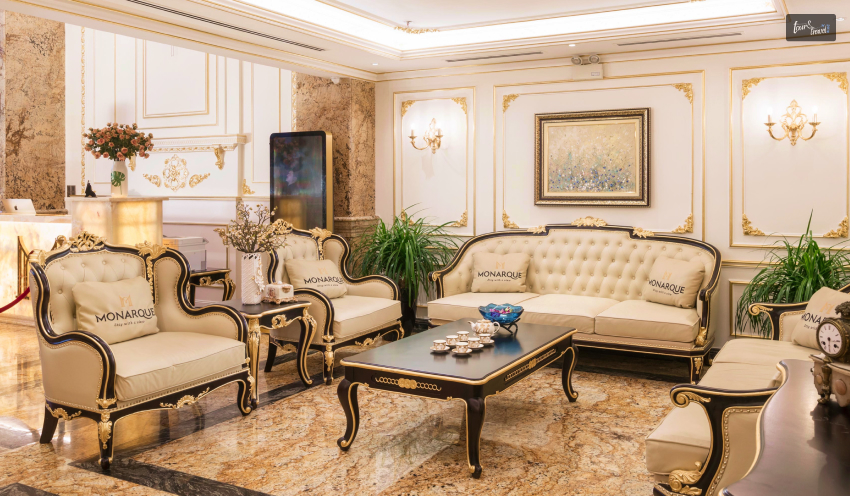
Monarque Hotel – This hotel is a beautiful stay with all the amenities made available! The hotel is mostly for accommodation as the outside is so beautiful and filled with activities and attractions for you to visit. The distance of the hotel is 27.7 km from the Golden Bridge.
If you are on a romantic trip, this hotel is definitely for you, as it is perfect for a romantic getaway! As partners, you can enjoy yourselves in the pool apart from the beautiful scenery outside.
Muong Thanh Luxury Song Han Hotel – This hotel is 24.6 km from the bridge and is one of the best regarding family stays.
The hotel has all the services and amenities, especially with amazing staff services. Traveling as a family, this hotel will ensure all your and your family’s requirements are met.
Ba Na Hills Mountain Resort – The distance between the resort and the Golden Bridge is 25 km with an altitude of 1487 m! It is one of the favorites based on the guests’ ratings and reviews. Apart from having exotic theme parks, the resort offers many recreational activities!
Start Packing…
Have you started packing yet? Now that we have discussed all about Golden Hand Bridge, Vietnam, you have to visit once in a lifetime. Attractions like these worldwide urge us to see them and create memories of a lifetime.
As humans, we are supposed to enjoy the beautiful scenic views worldwide. Even artificial ideas, along with the beauty of nature, confirm our growth and survival. Golden Hand Bridge is worth visiting, along with facilitating accommodations and other attractions.
Comment below to tell me why you want to visit Golden Hand Bridge, or have you already checked it off the bucket list?
Mashum Mollah is the feature writer of Search Engine Magazine and an SEO Analyst at Real Wealth Business. Over the last 3 years, He has successfully developed and implemented online marketing, SEO, and conversion campaigns for 50+ businesses of all sizes. He is the co-founder of Social Media Magazine.
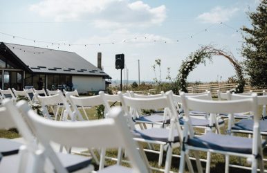
If you are hosting any kind of event for business or in a personal capacity, then you probably want it to be something that people will be talking about many years from now. We all want to create an event that provides people with the wow factor, but in order for that to happen, you would have to invest an incredible amount of money into getting all of the event equipment that you need. It’s likely that this will be only a one-off thing, and so it doesn’t make any financial sense to spend that amount of money.
What Are Event Equipment All About?
There is an alternative, however, and it comes in the form of event equipment hire in Perth. This allows you to have all of the latest event equipment for you to use, and you are only paying the cost to hire and not to buy. This leaves a lot more money left over to spend money on food for your guests, beverages, and anything else that comes to mind. These equipment hire specialists will bring everything to your location, and they will even set up everything for you as well.
The following are just some of the benefits of taking advantage of event equipment hire in Australia.
Event Equipment Hire: What Are The Benefits?
Everyone wants to make their events in life special. You do not have two opportunities. Hence, there is no way that you have to give the best shot. But events like corporate parties or office events are big challenges, and you have to look at hundreds of things.
You may not be able to manage them on your own. Therefore, it is always better to take the assistance of professionals. They are experts in their own fields. This section covers the benefits of hiring an event equipment service provider.
It saves time & money -
These are the two things that everyone wants to save here in Australia, and if you have an important event to organize like a wedding followed by a honeymoon, then being able to hire all the equipment that you need to be delivered to one place at one time, is exactly what you need. Hiring all of this equipment is surprisingly affordable, and you can basically hire everything that you need, from tables and chairs to plates and linen and even napkins as well.
It is so convenient -
There really is nothing easier than talking to your equipment hire service provider and then getting everything delivered to your location. They will set up all of the tables and chairs for you and even a dance floor if you don’t want to. Many important events run out of ice, and this is something that won’t happen to you because your event equipment hire company can provide you with an ice machine as well.
Evading Unnecessary Types Of Equipment
You may have observed that the marriage ceremonies are big events in an individual's life. You need many equipment to manage the ceremony. But if you decide to buy them all, it would be an act of foolishness. You can not buy so many chairs and tables for the gala event. It would be utter foolishness if you were looking to grab them. There are many things associated with events of such a grand scale; you don’t need them after the ceremony is over.
Variety
One of the reasons that you need the assistance of the party rentals is that you get the variety. Renting services have a type where you can select the ones that suit your budget and convenience. Moreover, the event rental service will offer you a much better service simply because you offered them business. Moreover, they can use their expertise to recommend the perfect floor plan you need for your event to be a huge success.
Bigger Discounts
When you are renting many items from the rental service, you are bound to get discounts on bulk rent. The event renting services is quite competitive, and you are bound to get the best services at a competitive cost. Yes, how can you undermine the discounts? You can surely be getting quality products and quality service, and that too at heavy discounts.
Additional Services
The party rental companies have their own network. Every event has its own nitty-gritty. There is a high possibility that you will not get them all with one company. But you do not have to worry a lot. Your event rental service will use its network to manage items they do not have. You do not have to be stressed out.
Environment-Friendly Services
This is the age of sustainability. It indicates that the stakeholders of this society will use the things sourced from renewable or green. The rental services use products sourced from natural materials like disposable plastic. Getting such services from the rental company denotes that you and nature share a win-win situation.
It takes away the stress -
It is a lot of responsibility to organize any kind of important event. If your boss has put all of the responsibility on your shoulders, then handle it like a pro and just turn to your event equipment hire company.
This will give you the perfect opportunity to impress your boss and your work colleagues as all of the equipment that is required arrives on time and in full. Stress is one of the major issues in today's life that takes an individual away from their ultimate goal.
Putting The Discussion To A Close
It isn’t just catering equipment that your event hire specialist can provide for you. If you want to make sure that the kids are occupied as well, then it is entirely possible that they will have a photo booth to rent. Maybe even a bouncy castle, and they may even be able to organize a band for you.
Read Also :
10 Useful Malayalam Words and Phrases to Learn before Traveling to Kerala
4 Tips for First-time Travelers to Bali
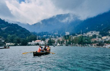
Despite the “Mind Your Own Business” video going viral and the debate between tourists and locals about using trash bins becoming the latest buzz, Nainital remains one of the most popular hill stations in India.
While overtourism can be a concern in this hill station or the state of Uttarakhand, you cannot ignore the fact that Taluka in Nainital introduced astrology tourism with the Nakshatra Sabha event in December 2024.
It was the fourth chapter of the first-ever astroturism campaign in India, organized by the Uttarakhand Tourism Development Board and Starscapes, a leading astrotourism company in the country.
Thanks to clear weather conditions, December is the best time to visit Nainital for stargazing. However, is it the best time to visit Nainital for a family trip?
In this Tour and Travel blog, we will discuss the ideal time for a Nainital trip with family and the places to visit every season.
Before that, let’s briefly overview Nainital as a travel destination.
Why Visit Nainital: Know The Lake District Of India
Nearest Airport: Pantnagar Airport (Distance: 40 Km)
Nearest Railway Station: Kathgodam Railway Station (Distance: 35 Km)
Nestled in the Kumaon Himalayas, Nainital is surrounded by Sapta-Shring or Seven Hills. The seven hills around this Lake District are:
Sher-Ka-Danda
Lariya-Kanta
Handi-Bandi
Naina
Alma
Deopata
Ayarpata
Further, this hill station, at an elevation of 2000 meters, is associated with the stories of Lord Shiva and Mata Sati.
It is said that the Lake was formed when Mata Sati's eyes fell during the Tandava Nritya, or the Dance of Destruction of Lord Mahadeva. The Naina Devi temple at the lake's edge is a popular religious site.
Also, the city has buildings and bungalows, a telltale of British colonial architecture. It was the summer capital of the United Provinces during the British Rule in India.
Moreover, the attractions in Nainital are endless. So, from a church in the wilderness to a bird-watching haven, you will find everything in Nainital.
What Is The Best Time To Visit Nainital?
Nainital is a year-round destination. However, April to June is the best time to visit Nainital while traveling with your family.
Further, if you want to see snowfall in Nainital, the best time to plan a visit is December to January.
In 2025, Nainital had its first snowfall on 11th January, resulting in a tourist boost to areas like Pangot Marg, Himalaya Darshan, Kilbury and China Peak.
Nevertheless, I have shared a table below with the month-wise temperature and precipitation possibilities in Nainital.
You can check that out to decide the best time to visit Nainital. Then, I will discuss the best attractions and places to visit in each season.
MonthsMaximum TemperatureDegree/Celsius) Lowest TemperatureDegree/Celsius)Rainfall/Precipitation (MM)January15448February17665March21950April 261340May271660June2819255July2520569August2419490September2417266October221348November2098December17620
So, as you can see, July, August, and September are the months with the highest rainfall in Nainital.
Heavy rainfall may cause landslides, road blockages, and many outdoor attractions or activities may not be operational in the monsoon season.
However, the monsoon is the best time to visit Nainital if you want to explore the quiet beauty of the hill station and its decor with shades of lush green.
What's So Attractive About Summer In Nainital?
I could give you more than one reason why you should visit between March to June. Nainital is like a pure place on earth wrapped around by gorgeous mountains and lakes.
The time between march to June is mostly spring and summer, and it is doubtlessly the best time to visit Nainital.
The mountains are always awake, watching and talking to you. Although the streets don't stay up so late, the clear night sky at Nainital makes up for the best place to watch stars at night.
The months from March to June are the ideal time for that. There are lakes so pristine and the pine tree so pretty waiting to welcome you.
1. Temperature Between March To June
Here, the summer temperature fluctuates between 11°C to 28°C in Nainital if you are visiting from March to June.
2. Warm Weather
In the summer, the town remains so warm and bright. You can take plenty of good photos. The sun wakes up the town with a good morning kiss, and the mountains are always awake and smiling.
Mornings are warm, with the cool wind blowing every now and then. The evening and the nights are slightly chilly.
3. Events To Take Part In
Yes, you can go paddling in the lake and do lots of other activities as well. However, the main reason for choosing summer is because of the events.
Ever heard of the Phool Dei? It is an event in Uttarakhand to celebrate a good harvest expecting a good harvest. Little children decorate the thresholds of their homes with freshly plucked flowers.
Locals, at this time, stay in a festive mood. You can taste the ceremonial pudding which is very famous at this point in time in Nainital.
People go out on the street and perform their local folk songs and dance in Joy.
4. Places To Visit
The festive mood here will keep you cheered up. However, summer also makes up for the best time to visit the tourist spots here. You can go to Naini Lake, Land's End, Caves Garden and.
Tiffin Top can be a great location if you want a recreational moment with your loved one or your family. You can enjoy the fresh look of the mountainscape and enjoy the sunrise there.
Just four kilometers away from the main town, Tiffin Top can also be a good opportunity if you are up for trekking.
Can You Visit Nainital In The Monsoon?
Yes, you obviously can. I told you that it is a year-round travel destination. The months from July to September mark the stay of the monsoon.
If you want to see the green mountains drenched in rain and clouds swirling up from deep within the mountains, then this is the best time to visit Nainital.
Although you can choose whether in Nainital and make your visit, the summer, according to most visitors, is the best time. But, my personal preference is monsoon.
Moreover, Nainital celebrates the Nanda Devi Festival in September. King Kalyan Chand of Chand Dynasty started this fair in the 16th century.
Further, Khatarua is another monsoon festival in Nainital, which is celebrated in mid-September.
On this day, children dance and throw cucumbers to the fire to celebrate the destruction of evil spirits.
Moreover, Gheeya Sankranti, or Olgia, is celebrated in Nainital in mid-August. It is a festival to exchange gratitude between landowners and farmers.
5. Is Winter The Best Time To Visit Nainital?
Winter is the best time to visit Nainital if you are looking for adventures in the snow-covered hills.
Further, during the winter months, the Naini Lake promenade becomes a bustling hub for ice skating, scenic walks, and snow trekking.
Also, during winter, you can visit places like Bhimtal Lake, Kainchi Dham, Snow View Point, and China Peak.
Moreover, Nainital celebrates Sharadotsav in October and the Uttrayani Festival in mid-January.
Both festivals have distinct rituals and many visitors, including foreigners. Further, they are great to experience the local culture.
In addition, Christmas is the most happening event in Nainital, with many outdoor activities, such as paragliding, camping, horse riding, and zoo visits.
Frequently Asked Questions (FAQs):
Most of your questions are answered through the sections above. However, I have offered some additional questions and answers just to make sure that you get clean and complete information.
1. Which Weather Is Best For Nainital? From March to June is a long span. But, if you want me to specify the best months to visit Nainital, I will suggest a time between May to June. The temperature is pleasant, and the weather is clean and simple for a good tour. 2. How Many Days In Nainital Is Enough? You will need three minimum days to explore and relax in the beautiful hill destination known as Nainital. If you want to visit all the popular locations here, then a three days trip would be enough. 3. How Much Does A Nainital Trip Cost? If you are planning a short trip of four days and three nights, then you can expect your budget to be around 14,799.
Bottom Line!
If you want to experience Snowfall in Nainital, I will suggest you go there during the winter. January will be the best time.
The monsoon makes the place look green, saturated, and fresh, and the summer is all about vibrance and joy.
So, if you are looking for the best time to visit Nainital, then I will suggest you go wherever your heart wants.
Did you find the answer you were looking for? Tell us what you think about it. We are also open to questions.
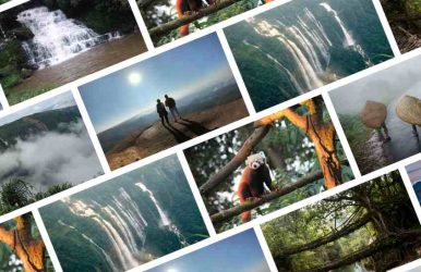
Meghalaya, or the Abode of Clouds, here you will find that nature has to give. It is one of the best places for its biodiversity richness. Known best for its famous monsoon seasons, Meghalaya has the most dramatic natural terrains with rich cultural festivals.
Having such beautiful natural diversities, which are among the best places to visit in Meghalaya. The tribals of Garos, Jaintias, and Khasis make up the majority of the population.
Meghalaya: Abode Of Clouds!
Located in the northeastern parts of India, with Shilong as its capital. During the British rule of India, it was dubbed the “Scotland of the East.”
With a range of beautiful terrains, Meghalaya is surely going to surprise your imagination. With beautiful greenery everywhere, with forests, valleys, waterfalls, and mountains, that are one of the best places to visit in Meghalaya.
But since Meghalaya is known for its monsoon seasons, what is the best time to visit there?
What Is The Best Time To Visit Meghalaya?
Since Meghalaya is one of the wettest places in India, with the occasional cloudbursts and landslides, you need to know the best time to visit there.
Weather Condition In Meghalaya
Oct-Feb = 9c Apr-Jun = 21c June-Oct =15c
Peak Season
When the temperature is between 16c and 31c, that is the best time to visit Meghalaya. This will probably be from April and June. During this time, Meghalaya has the optimum temperature for you to explore the place.
Shoulder Season
From the months of November to March receives a moderate amount of tourists, as the weather is cold and misty at the same time.
Low Season
The lowest season for tourism in Meghalaya is from July to October. During this time, the state receives about moderate to heavy rainfall.
Best Places To Visit In Meghalaya
Now that you know what the best time to visit Meghalaya is, you need to know what are the top Meghalaya tourist places.
1. Cherrapunji
Popularly regarded as the wettest place on Earth, Cherrapunji has the best lush greenery you will ever see. Here you will find the highest rainfall any time of the year.
Tourists from all over the world come here to see the most beautiful waterfalls, like Dain-Thlen,Nohkalikai, and Kyrem. Cherrapunji is one of the best places to visit in Meghalaya.
Specialty - An abundance of natural scenic beauty and environmental attractions.
Places To Stay - Polo Orchid Resort Cherrapunjee, Jiva Resort Cherrapunjee and Saimika Resort.
Attractions - Krem Mawmluh, Wakaba Falls, Double Decker Living Root Bridge, and also Nohkalikai Waterfalls.
How To Reach - From Guwahati, it's 166km, And from Cherrapunji Umroi Airport, it's 79km.
2. Shillong
Known as the Scotland of the East, Shillong is the capital of Meghalaya. Away from the bustling life of the city, Shillong has beautiful forests, hills, and mesmerizing scenic beauty. Shillong is considered the Meghalayan Gateway.
Popular landmarks of Shillong are Elephant falls, Maharam, Lady Hydari Park, Bhowal, Mylliem, and Langrim.
Specialty - Mesmerizing view, the beauty of nature, and its popular landmarks.
Attractions - Elephant falls, Maharam, Lady Hydari Park, Bhowal, Mylliem, and Langrim.
Places To Stay - Pinewood Hotel, The Loft-Executive Inn, Hotel Polo Towers Shillong, and Tripura Castle.
Location - East Central Meghalaya.
Best Time To Visit - From September to May.
3. Mawsynram
Out of all the places in Meghalaya, Mawsynram receives the most rainfall each year. This is why here you will find the most greenery and beautiful green hills and valleys. Mawsynram receives about 11,872 mm of rainfall each year.
Specialty - The most beautiful waterfalls.
Location - The East Khasi Hills, Meghalaya.
Best Time To Visit - From April to June.
4. Balpakaram National Park
Known as a traveler’s paradise, the Balpakaram National Park is a “Land of Spirits” for its rich natural biodiversity. With its beautiful wildlife with animals like Tiger, Leopard, Deer, Buffalo, Elephant, and Red Panda.
Specialty - It is rich in natural biodiversity.
Location - Western Meghalaya and Garo Hills.
Best Time To Visit - From October to March.
Entry Free - Free.
5. Nohkalikai Falls
The Nohkalikai Falls is the 4th most noted waterfalls in the World. The height of this fall is about 335 meters from the cliff to the ground. The falls are considered “the pride of the territory of Meghalaya.”
Specialty - It is like paradise with an extraordinary scenic view.
Entry Fee - INR 10.
Timing - From 8 am to 5 pm.
6. Double-decker Living Root Bridge
Located in Cherrapunji, the double-decker living root bridge is famous all over, as the bridge is made up of roots. The roots are of rubber trees. The bridge is about 3km long and about 2400ft in height.
Specialty - The oldest of natural bridges.
Location - Cherrapunji, Meghalaya.
Best Time To Visit - Anytime other than from May to September, due to the slippery.
Trek Time - It takes about 4 to 6 hours.
7. Kyllang Rock
This extraordinary rock is made entirely out of red stone. The rock is 54ooft above sea level and 1000ft in width. The hike up the rock gives a beautiful scene with rhododendrons and shrubs.
Specialty - It is on the highest points in all of Meghalaya.
Location - West Khasi Hills, Shillong, Meghalaya.
Best Time To Visit - Anytime, except the monsoon.
8. Elephant Falls
Meghalaya is known to have the best waterfalls in all of India. And Elephant Falls is definitely one of that beautiful waterfalls. It is called Elephant falls as it has an Elephant-shaped stone at its foot of it. It is one of the best places to visit in Meghalaya.
Specialty - The falls are surrounded by beautiful scenic beauty.
Location - It is only 12km from Shillong.
Best Time To Visit - During Monsoon.
Frequently Asked Questions (FAQs):
Now that you know what the best time to visit Meghalaya and the best tourist places is, you won’t have any other problems. But if you do, here are some questions asked by other people.
1. What Is The Popular Place Of Meghalaya? The most popular Meghalaya places to visit are:1. Mawsynram2. Nohakalikai Falls3. Mawlynnong Village4. Umiam Lake5. Seven Sisters Falls6. Living Root Bridges 2. Does Meghalaya Have Snow? Though the state of Meghalaya has a higher elevation, it doesn’t receive any snowfall throughout the year. But due to humidity and low temperature, frost forms which can look like snow but are not. 3. What Is Famous Food Of Meghalaya? The food that is famous in Meghalaya is a spicy preparation of fish or meat and rice. They are great at rearing pigs, goats, cows, ducks, and fowl for their meat.
Visit Now!
If you are an avid nature lover, then visiting Meghalaya should definitely be on your bucket list. There are some beautiful places to visit in Meghalaya. And if you are a mountain lover, then you need to visit here once.
Hopefully, this article encourages you to book your tickets soon for Meghalaya. Let us know in the comments where in India you wanna visit next.


 Related