


 Related
Is Margaritaville At Sea Worth It? (Know The Destinations, Experiences, Things To Do, And More)
BY Sibashree Sep 4, 2025
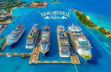
“Wasting away again in Margaritaville (yes, I am, yes, I am, I'm) Searching for my lost shaker of salt Some people claim that there's a woman to blame And I know, it's my own damn fault…” Jimmy Buffett, the man behind this iconic song of 1977, gave us Margaritaville. The song spread its wings and became a sprawling lifestyle and hospitality brand, attracting visitors to the perfect island-inspired vacations. Today, the brand is on the verge of a great expansion, with the announcement of Margaritaville Beachcomber, the newest addition to its cruise line, Margaritaville At Sea. Martha Brabham, the head of design at Margaritaville At Sea, has said that carefree escapism, surfing fun, and beach scenes have been the main inspiration behind Margaritaville Beachcomber. Nevertheless, it is not just about the newest additions, Margaritaville at Sea Islander and Margaritaville at Sea Paradise, which have already been catering to tourists who want to optimize their coastal fun. In this Tour and Travel Blog, we will talk about these three cruising ships, things to do at Margaritaville on the cruise, experiences, charges, and more. Check Out These Key Areas:Who Owns Margaritaville At Sea?How Many Ships Does Margaritaville At Sea Have? 1. Margaritaville At Sea Islander2. Margaritaville At Sea Paradise3. Margaritaville At Sea Beachcomber What Are The Destinations Covered By Margaritaville At Sea?1. Grand Bahama Island2. Nassau3. Key West4. Cozumel, Mexico5. Progreso, Mexico6. Costa Maya7. Western Caribbean8. Southern Caribbean What Are The Things To Do At Margaritaville At Sea? 1. Sail The Haunted Seas2. Spa & Fitness 3. Casino4. Fun & GamesCan I Plan My Wedding At Margaritaville At Sea? What Are The Onboard Charges For Margaritaville At Sea? How Can I Book Margaritaville At Sea?Margaritaville At Sea Vs. Royal Caribbean: Which One Is Better? Margaritaville At Sea Excels At:Royal Caribbean Excels At: Is Margaritaville At Sea Legit? Margaritaville At Sea Reviews Margaritaville At Sea: What Is The Future? A Tour And Travel Blog Insight Margaritaville At Sea: Frequently Asked Questions (FAQs) Who Owns Margaritaville At Sea? View this post on Instagram A post shared by Margaritaville at Sea (@margaritavilleatsea) Jimmy Buffett, the celebrated singer and songwriter, started the Margaritaville At Sea brand in Key West in 1985. Today, Classica Cruise Operator Ltd, a license holder by and through Margaritaville Enterprises, LLC, operates and does business as Margaritaville at Sea®. Furthermore, Margaritaville Vacation Club, Inc., in Orlando, Florida, is a corporation with separate ownership and operations. It is also licensed by Margaritaville Enterprises, LLC, to manage Margaritaville at Sea timeshare offers. Margaritaville Enterprises, LLC owns licenses and intellectual properties for the cruise line. How Many Ships Does Margaritaville At Sea Have? View this post on Instagram A post shared by Margaritaville at Sea (@margaritavilleatsea) Margaritaville At Sea now has two ships, Margaritaville at Sea Islander and Margaritaville at Sea Paradise. However, its third ship, Margaritaville At Sea Beachcomber, is slated to start its operations in 2026. Here is a brief overview of the two existing ships and the one to be added. 1. Margaritaville At Sea Islander View this post on Instagram A post shared by Margaritaville at Sea (@margaritavilleatsea) Margaritaville at Sea Islander has unique features such as: A Three-Story Poolside LandShark Bar The Tiki Bar Outdoor And Lounge Pool for Adults A 14-Story Tropical Atrium Amphibian Splash and Slide It departs from Port Tampa Bay and takes you to Key West, Mexico, and the Caribbean. The Margaritaville At Sea Islander packages for individual and family travelers vary, and they are customized according to your requirements. Most of the packages here are under $200, while the more high-end packages go up to $799. You can contact 8008147100 to customize your package. 2. Margaritaville At Sea Paradise View this post on Instagram A post shared by Margaritaville at Sea (@margaritavilleatsea) The Margaritaville at Sea Paradise takes you from the Port of Palm Beach to The Bahamas and Key West. It offers a shorter cruise getaway and has the best features, such as: Pickleball Showdowns Poolside Lounging Live Music Wine Tasting Sundeck Activities Karoake Game Shows Here also, you can customize the package; the packages will be within $500 per person. 3. Margaritaville At Sea Beachcomber View this post on Instagram A post shared by Margaritaville at Sea (@margaritavilleatsea) Beachcomber, the newest addition, weighs more than 100,000 gross tons. It promises to offer the ultimate carefree escapism when it stars sailing. What Are The Destinations Covered By Margaritaville At Sea? Margaritaville at Sea offers diverse coastal destinations in Florida, Mexico, and the Caribbean. Here are the places. 1. Grand Bahama Island Enjoy shore excursions at Grand Bahama Island, known for its white sand beaches. It is the largest city in The Bahamas. Furthermore, this Bahamas city has coral reefs, national parks, bustling markets, and more. Do you want to know if the Bahamas is safe or not for a cruise trip? Check out our travel guide. 2. Nassau Nassau is the melting point of adventure and a laid-back vibe. Along with being a perfect coastal getaway with clear waters, Nassau is also known for its historic sites. Don’t miss the Queen's Staircase and exploring the Nassau Harbor. 3. Key West With coral reefs and the bustling Duval Street, Key West is a cruising paradise. Everywhere you look, you will find an Insta-worthy view. Furthermore, Key West is one of the most popular cruising destinations for couples. 4. Cozumel, Mexico Tropical jungles, palm trees, and the sound of waves! Cozumel is pristine. You will love its white sandy beaches, and the beach bars here are amazing. 5. Progreso, Mexico Located in the Yucatán Peninsula, home to iconic tourist destinations such as Valladolid, Mexico, Progreso is home to the rich Mayan cultural heritage. Explore the ancient ruins of Chichen Itza here. 6. Costa Maya Costa Maya has come a long way from being a quaint fishing village. With Chacchoben's pyramids and other Mayan ruins and its underwater wonders, it is now a stellar tourism attraction. It is also home to the largest coral reef in the northern hemisphere. 7. Western Caribbean Belize, Grand Cayman, Jamaica, and Roatan are the destinations covered by Margaritaville at Sea in the Western Caribbean. Exploring the pristine beaches, meeting stingrays, and watching the Dunn's River Falls are the main attractions of this cruising journey. 8. Southern Caribbean The pastel-colored streets of the Caribbean look most vibrant against the white sandy beaches. Aruba is one of the main highlights of this Southern Caribbean cruising. It has coral reefs and national parks, making it an ideal destination for adventurers. What Are The Things To Do At Margaritaville At Sea? View this post on Instagram A post shared by Margaritaville at Sea (@margaritavilleatsea) Margaritaville At Sea is for all types of travelers. From having a good time eating and drinking to the ultimate casino fun, these are the best things to do on your cruising vacation. Relaxing at Pools and Hot Tubs Having a Good Time at Bars and Lounges Enjoying Live Music and Entertainment Playing Casino Rejuvenating at Spas and Wellness Facilities Eating and Drinking Know The Experiences At Margaritaville At Sea The experiences at Margaritaville At Sea are the most unique. Bring out your wicked side and enjoy! 1. Sail The Haunted Seas View this post on Instagram A post shared by Margaritaville at Sea (@margaritavilleatsea) As the name suggests, this cruise experience from 7th September to 1st November is about White Hot Neon Nightmares, Wicked-Win Costume Contests, Scary Food Fun, and more. Hear & See “It's a thin line between Saturday night and Sunday morning." Adhering to this line of Jimmy Buffett, Hear & See is all about live music and entertainment with musicians, DJs, comedians, and more! 2. Spa & Fitness You can enjoy professional spa services here for physical and mental rejuvenation. With the state-of-the-art technique, the cruise offers customized spa services. 3. Casino Margaritaville Casino welcomes first-time players and experts. Enjoy live table games and your favorite slots. 4. Fun & Games The fun and games at Margaritaville At Sea are for kids, teens, and all. Kids above 3 years of age can take part in these fun activities. Can I Plan My Wedding At Margaritaville At Sea? Yes, you can plan your wedding at Margaritaville At Sea. Three types of packages offered are: Paradise Package Elation Package Bliss Package With the amenities already included, you can also choose the add-ons. There is a requirement for a minimum of eight staterooms for each wedding package. You must make the bookings at least 60 days in advance. What Are The Onboard Charges For Margaritaville At Sea? View this post on Instagram A post shared by Margaritaville at Sea (@margaritavilleatsea) Onboard charges are charges excluding the package you have prepaid for. Margaritaville At Sea has divided its on-board changes into three categories. Types of Onboard ChargesDetailsGratuities• $20.00 Per Night Per Person for Staterooms• $24.00 Per Night Per Person for SuitesFuel Supplements• $15 Per Night Per Person for Margaritaville at Sea Paradise• No Charges are Applicable for Margaritaville at Sea Islander. • Fuel Supplement costs can vary as per your Ticket Contract and the current fuel Cost. Service Charge• 20% of the Service Availed Of How Can I Book Margaritaville At Sea? Here is the step-by-step guide for booking your Margaritaville cruise. 1. Visit the official website and click on the blue button, stating “Book Now.” 2. Once you click the button, you will get a pop-up. It says that you can get a cruise certificate for two $349 and sail at a time of your convenience. 3. However, if you want to sail immediately, you have to select your departure dates, departure from, destination, and duration from the dropdown menus at the top. 4. Then, you will have the available options for your selected dates and destinations. Once you select an option, Margaritaville at Sea will offer you a complete itinerary and charges for your chosen trip. 5. Now, click on the continue booking button to select your stateroom and stateroom location. 6. Finally, proceed to checkout. Fill in your details and make payments. Margaritaville At Sea Vs. Royal Caribbean: Which One Is Better? View this post on Instagram A post shared by Margaritaville at Sea (@margaritavilleatsea) It is difficult to pick between these two. And even a hardcore Royal Caribbean fan will agree that Margaritaville does certain things better than Royal Caribbean. It is also the other way around. Margaritaville At Sea Excels At: A Retro Vibe with Nostalgia as the Main Theme in Ship Designs and Experiences A Laid-Back Party Vibe Shorter Cruising Vacations More Affordable Royal Caribbean Excels At: Newer and Bigger Ships More Suitable for Family Vacations Opulent Experience and Longer Vacations Wider Range of Destinations Covered Is Margaritaville At Sea Legit? View this post on Instagram A post shared by Margaritaville at Sea (@margaritavilleatsea) Yes, with reasonable and customized cruising vacation packages in Mexico, Florida, and the Caribbean, Margaritaville At Sea is one of the most reputable cruise lines. Add to that the legacy of Jimmy Buffett and the signature hospitality of the Margaritaville brand he established. Moreover, the cruise line has a well-defined cancellation policy. Also, the cruise line has multiple accolades to its name. Check out the following. Conde Nash Traveler Readers’ Choice Awards, 2024 2024 Cruisecritic Best in Cruise 2025 Newsweek Readers’ Choice Award for Best Ship for Families 2025 USA Today Readers’ Choice Award for Best Ocean Cruise Line 2025 USA Today Readers’ Choice Award for Best Ocean Cruise Line for Solo Travelers 2025 USA Today Readers’ Choice Award for Best Ocean Cruise Line for Families Margaritaville At Sea Reviews Here is what the travelers of Margaritaville at Sea have to say about their experiences. 1. “I was thrilled to find that all my bad thoughts towards this cruise line were totally unfounded. They've responded quickly to any issues people have complained about. Now, if we could get an app, and a better muster drill it would be perfect!” - Rebecca R. 2. “I enjoyed the variety of activities and days filled with activities. The military appreciation ceremony honoring our nation’s heroes was wonderful.” - Jacob W. 3. “I really enjoyed the shows that we saw, the interaction with the crew and passengers. I also enjoyed that the boat was not to its full capacity that made it really relaxing. The dinner at the JW steakhouse was amazing the service our waiters JONA and his crew gave us was excellent. Our housekeeping personal was also very friendly and great hospitality.” - Jordan R. Margaritaville At Sea: What Is The Future? A Tour And Travel Blog Insight View this post on Instagram A post shared by Margaritaville at Sea (@margaritavilleatsea) Along with announcing the launch of its third vessel, Margaritaville At Sea is now expanding its service by offering longer vacation packages. Thus, the cruise line plans to introduce more flexibility in its service and cater to a wide range of cruise vacationers. Furthermore, the Heroes Sail Free program of Margaritaville At Sea has already gained popularity. It offers free vacation benefits to “active-duty” military officials, first responders, and veterans. So, from offering unique experiences to showing its commitment to great causes with innovative programs, Margaritaville At Sea continues to maintain a strong foothold in the global cruising industry. Margaritaville At Sea: Frequently Asked Questions (FAQs) Here are the frequently asked questions and answers about Margaritaville at Sea. 1. Can I Cancel My Booking At Margaritaville At Sea? Yes, you can cancel your booking at Margaritaville At Sea. They have well-defined policies regarding guest booking cancellations and refunds. You can contact 800-814-7100 to obtain more information. 2. Is Food Included In Margaritaville At Sea? Yes, food is included in your booking contract for Margaritaville At Sea. Food includes dining at the main dining halls, buffets, and selected restaurants. However, alcoholic beverages and special dining options are not included in this. 3. Is Margaritaville At Sea A Party Cruise? Margaritaville At Sea is not essentially a party cruise. However, you can plan your wedding on the cruise, and the atmosphere remains quite lively with music and entertainment shows. Moreover, the spirit is high during special events such as “Sail Yeah Deck Party,” “Rock the Trop,” etc. 4. Is Margaritaville At Sea Great For Family? Yes, Margaritaville at Sea is great for families. It offers special packages and experiences for kids and teenagers. Furthermore, it is the winner of the 2025 Newsweek Readers’ Choice Award for Best Ship for Families and the 2025 USA Today Readers’ Choice Award for Best Ocean Cruise Line for Families accolades. 5. Does Margaritaville At Sea Have A Free Icecream? Yes, Margaritaville At Sea offers free ice cream in specific hours and at specific locations. You will get it near Cheeseburger in Paradise, Mexican Cantina, and the Port of Indecision Buffet. Read Also: Sailing Into the Wild: Why a Trollfjord Cruise Is Norway’s Most Magical Fjord Experience Single Parent Cruising Tips and Tricks for a Memorable Adventure Here is a List of Best Cruises Out of Galveston for 2025