


 Related

Living Your Solo Travel Dreams: 8+ Best Places To Travel Solo Female In US
BY Sibashree Nov 11, 2024
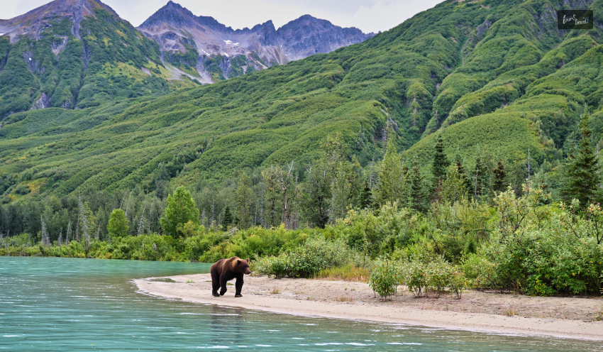
The USA is a safe country for female solo travelers. It has secured the 37th position in the “Women Peace and Security Index” among 177 nations in 2023. Further, the 2023 report of the TrustedHousesitters says that there is a massive increase in the number of female travelers booking solo trips. Specifically, the report registers a 193% growth in the number of solo female travelers in 2022. Now, women often find themselves solo. It can be a breakup, a change of job, a need for some space and me-time amidst so many responsibilities…or just the much-awaited introspection time! It’s great that the best places to travel solo female in the US await you with eclectic experiences. While Savannah in Georgia spills history and wins hearts with its architecture, Miami emerges as a stunner for its coastal fun and vibrant nightlife. So, let’s discover the best places to travel solo female in US. Best Places To Travel Solo Female In US: 8+ Destinations You Will Fall In Love With “Take a break, girl!” Has this been on your mind for the longest time? It’s time to enjoy your own company and explore new places at your own pace. Solo traveling is cool in many places in the USA. However, to begin with, you can check out the following places. I have enlisted the places based on our in-house “Solo Travel Safety Meter” scores out of 5. Further, our “Solo Travel Safety Meter” has assessed the availability of basic amenities, safety provisions, and things to do at those places. Moreover, we have done research on online reviews to pick the best places to travel solo female in US. 1. Miami, Florida Tour and Travel Safety Meter Rating: 4.4 Best Time to Visit Miami: December to February and March to May Miami is for the social butterflies and mermaids! You can spend the day by the famous beaches of Miami and enjoy the best nightlife at the nightclubs. Further, you will love the Latin cuisine in Miami. Have a look at the best beaches in Miami. South Beach Haulover Naturist Beach, North Beach Haulover Dog Beach Bill Baggs Cape Florida State Park Moreover, if you want to chill at nightclubs, consider exploring places like El Patio Wynwood, Tipsy Flamingo, Club Space, etc. 2. Savannah, Georgia Tour and Travel Safety Meter Rating: 4.3 Best Time to Visit: March to July If you visit Savannah between March and July, you will cherish the warm weather and flowers in full bloom. Further, Savannah is home to the Wormsloe Historic Site, William Scarbrough House, Cathedral of St. John the Baptist, and many other ancient and prominent architecture. So, you can call Savannah the historical hub of the country. Savannah is also known for its warm hospitality. 3. Seattle, Washington Tour and Travel Safety Meter Rating: 4.1 Best Time to Visit: July to September Seattle or the Emerald City will offer you the best of urban and rural lives. Space Needle and Pike Place Market are some prominent places to explore when you are in Seattle. From the Space Needle, you will enjoy a 360-degree view of Mount Rainier, the Olympic mountain ranges, Cascades, and downtown. Moreover, in Seattle, you will enjoy a ferry ride to islands nearby and the coffee plantations of the city will mesmerize you. 4. Charleston, South Carolina Tour and Travel Safety Meter Rating: 4 Best Time to Visit: March to May and September to November If you are looking for a relaxing solo traveling experience, Charleston will be your go-to destination. Further, if you are a dark academia fan, you will love taking a stroll along the cobblestone streets of the historic district. You will also come across scenic plantations in Charleston. Moreover, for the most peaceful experience, you can enjoy a short walk in Battery. You will enjoy the most beautiful view of the harbor from here. 5. Asheville, North Carolina Tour and Travel Safety Meter Rating: 3.9 Best Time to Visit: September to November The beauty of the Blue Ridge Mountains graces Asheville in North Carolina. Along with being a place of great scenic beauty, it is also known as a hub of art and culture. Further, when in Asheville, you can explore the Blue Ridge Parkway, the Great Smoky Mountains National Park, and Pisgah National Forest. Moreover, Asheville offers you the best farm-to-table dining experiences. HomeGrown, Chestnut, Vivian, and Corner Kitchen are some of the best locations for farm-to-table dining indulgence in Asheville. 6. Austin, Texas Tour and Travel Safety Meter Rating: 3.8 Best Time to Visit: March to May and September to November Austin will win you over with its vibrant culture. It is the biggest draw for the music and gastronomic enthusiasts. Austin houses some of the best BBQ joints in the country. You can visit any of the following places to cherish the taste of Texas-style BBQ. Smokin' Brew-B-Q Terry Black's Barbecue The Salt Lick BBQ Did You Know?You will get the South Texas barbecue style in the eateries of Austin. Here, the smoked meat is served with molasses-based barbecue sauce. This sauce preserves the moisture of the meat. So, you enjoy a moist and flavorful delicacy. Moreover, Austin has the Colorado River. If you are an adventurous soul, you can take part in multiple outdoor activities along that river. 7. Hot Springs, Arkansas Tour and Travel Safety Meter Rating: 3.6 Best Time to Visit: April to May and September to October Are you looking for a relaxing getaway? Hot Springs, Arkansas, will be the ideal destination for you. Named “the Valley of the Vapors” by native Americans, Hot Springs has natural hot springs producing water with a temperature of “143 degrees Fahrenheit.” Bathhouse Row and Quapaw Baths & Spa are some of the best places to indulge in the natural spa experience. 8. Alamogordo, New Mexico Tour and Travel Safety Meter Rating: 3.5 Best Time to Visit: May to October Alamogordo is home to the White Sands National Park. You will love the long stretches of gypsum sand dunes here. In fact, it is the largest gypsum dune field in the world. However, the fossilized footprints of humans and animals are the most fascinating things in the park. These footprints are from the Ice Age. Despite being one of the best places to travel solo female in US, Alamogordo is underrated. You will love its wine and have it with some pistachios for the best experience. 9. Anchorage, Alaska Tour and Travel Safety Meter Rating: 3.3 Best Time to Visit: March to November One of the best places to travel solo female in US, Anchorage is great for cruise trips. The cruise trips in Anchorage are great as you enjoy the bliss of solo travel and enjoy the company of a group with similar interests. The exchange of knowledge and experience always works when you are traveling to a new place. The cruise trip in Alaska will make you meet the big five of the state: caribou, bear, Dall sheep, moose, and wolf. Further, as a solo female traveler, you will enjoy the following activities here. Dog sledding Watching the Northern Lights Visiting the Glaciers Moreover, you can stargaze and enjoy a midnight stroll in Anchorage without safety concerns. Also read Why Include Whale Watching In Your LA Itinerary. Traveling On A Budget: Tips For Affordable Adventures. From Cocktails To Kickflips: Must-Try Activities In San Diego.