


 Related
Raja Ampat Marine Life Guide: What Marine Species To See In Raja Ampat, Indonesia?
BY Sibashree Dec 29, 2025
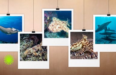
Have you ever been to a place where the clarity of the water feels like liquid air? Yes, you have heard it right. I am talking about the waters of Raja Ampat in Indonesia. Also, the dense coral reefs here look like a kaleidoscope in motion. Its strategic location in the Coral Triangle in West Papua has also blessed it with a diverse marine life. Did you know that Raja Ampat has “75% of the known coral species” and more than 1,320 species of reef fish (Source: UNESCO)? No wonder it is called the Amazon of the Seas. Also, with UNESCO designating it as a Biosphere Reserve on 27th September, 2025, it is now one of the just two places on the earth to have the distinction of being a UNESCO Global Geopark and Biosphere Reserve at the same time. So, consisting of four islands (Raja Ampat means Four Islands), Waigeo, Salawati, Batanta, and Misool, Raja Ampat is like the biological "bullseye” as the most diverse marine habitat on the planet. Hi, in this Raja Ampat marine life guide, I will be talking about what marine species to see in Raja Ampat Indonesia. Also, if you want to make the most of the underwater wonderland of Raja Ampat, check out our Raja Ampat diving trips. With an unbelievable marine life and rock formations that go back to 400 million years, Raja Ampat is the “living laboratory” of marine conservation according to UNESCO. So, when the water here has more than a thousand species to spot, let’s find out the Big 5 of the water here. These creatures are unique, and they are majestic. They also represent the mystery of water. 1. Manta Rays (Oceanic Manta And Reef Manta) Raja Ampat is one of the rarest places in the world to have oceanic and reef Manta Rays. You can even spot them at the same time at the same cleaning station. Oceanic Manta Vs Reef Manta Reef Mantas, with even a massive 5-meter wingspan, are smaller than the Ocean Mantas. The wingspan of the Ocean Mantas is close to 7 meters. Furthermore, Reef Mantas stay in large, social groups, while the Oceanic Mantas are pelagic wanderers. Also, Oceanic Mantas feature a “T” shape on their shoulders. On the other hand, you can identify Reef Mantas from the “Y” or “V” shapes on their back. What Are The Best Sites For Spotting Manta Rays In Raja Ampat? Manta Sandy in the Dampier Strait and Magic Mountain in Misool are the best places for spotting Manta Rays. In the Dampier Strait is a quintessential cleaning station for Reef Mantas. The site is shallow, and you will find the Reef Mantas moving over the "bommes" with cleaner wrasse doing their work. Furthermore, Magic Mountain is the place where you will find both species. So, it looks like a Manta Ballet against the backdrop of the dark blue water. 2. Walking Shark Raja Ampat (Epaulette Shark) And Where To Find Them The Walking Shark, or the Epaulette Shark, is the mascot of Raja Ampat. These are called walking sharks because they can use their pectoral and pelvic fins like legs. So, they do not swim and “walk” across the sea floor. These are nocturnal hunters, strictly. If you are going night snorkeling at Sawinggrai or Arborek, you will spot them walking past your mask. It’s a surreal experience, I must say! 3. Wobbegong Sharks The Wobbegong Sharks usually rest on the seabed. They also remain tucked under a coral ledge. Wobbegong Shark Sightings: Spotting The Masters Of Camouflage These sharks are also known as “Carpet Sharks.” They have mottled and ornate patterns. So, they can disguise themselves well. You will also spot a beard of fleshy tassels around their mouths. You will often mistake these predators for a piece of weed-covered reef. Sardine Reef in the Dampier Strait and various areas around Misool to find the Wobbegong Sharks. 4. Pygmy Seahorses Pygmy Seahorses in Raja Ampat come in various species, such as Bargibant’s, Denise’s, and Pontoh. Bargibant’s is the most popular, and they have pinkish nodules, which match the color of their host coral. Bargibant also hides in the Gorgonian fans. They never leave their specific host fan, spending their entire lives blending into its polyps. Denise’s pygmies are slender, and the whitish Pontoh pygmies are found on hydroids and algae. Pygmy Seahorse Habitats In Raja Ampat You will love exploring the top Raja Ampat dive sites in search of the Pygmy Seahorses. Dampier Strait, especially sites such as Cape Kri, Blue Magic, and Misool, are the best sites to spot these adorable marine creatures. 5. Cetaceans (Whales And Dolphins) The archipelago has deep-water trenches and powerful currents. So, the water is an important highway for marine animals. Spotting The Whales And Dolphins The Dampier Strait is a primary migration corridor. So, you will frequently spot Spinner and Bottlenose Dolphins near your diveaboards in Raja Ampat. Furthermore, you will find Pilot Whales, Sperm Whales, or Orcas in the deep channels between the islands. Rare & Macro Critters: A Photographer’s Dream Raja Ampat coral diversity and the macro critters make it a favorite of photographers. You will come across diverse, bizarre animals in the reef. 1. Nudibranchs And Flatworms: The Living Jewels Underwater Nudibranchs or sea slugs are vibrant, and they shine like jewels in the deep blue water of Raja Ampat, thanks to their neon shades. You will find various species of nudibranchs and flatworms in the waters of Raja Ampat. Chromodoris is the most common species, and they look unreal. They feel like they're straight from the pages of sci-fi movies. You will find them in Misool areas such as Nudi Rock and Lalosi in the Dampier Strait. 2. Blue Ringed Octopus And Cuttlefish The tiny and lethal marine wonders, blue-ringed octopuses, come with a brown body. They pulse with glowing blue rings when they feel threatened. Another marine wonder is the Broadclub Cuttlefish. They use their skin as a television screen. So, you will notice changing colors and patterns in seconds. Misool, Dampier Strait, and water near Mioskon Island are the best places to find these macro marine creatures. 3. Wonderpus And Mimic Octopus You will find Mimic Octopus mainly in sandy areas. As the name suggests, they can impersonate other sea animals such as lionfish and sea snakes. Wonderplus has long and slender arms. Also, Wonderplus has intricate white patterns on its rusty brown body. Spot these stunning marine animals in the water of Misool, Waigeo, and Batanta. Marine Life By Habitat: Where To Look The best diving and snorkeling site for you in Raja Ampat will depend on the marine experience/animals you want to encounter. So, you have to understand the habitat. 1. The Blue Water Mangroves The Blue Water Mangroves are in the Passage or near Gam Island. These are not usual muddy mangroves. The water here is crystal clear, and it functions as a juvenile fish nursery where you can see soft corals growing on tree roots. It is a rare phenomenon. 2. The Seamouts Magic Mountain or Sardine Reef are the seamouts, and they are the main action spots because of their position in the path of strong currents. The strong current here attracts many pelagic species. So, you will find "walls" of Bigeye Trevally, schools of Grey Reef Sharks, and thousands of Barracuda. 3. The Muck Muck diving is a technical term, and it means exploring the sandy bottoms of the water. It is wrong to consider this place as empty, as you will find the rarest critters, such as Bobtail Squid, Seahorses, and Frogfish, here. These critters usually remain hidden in plain sight. Raja Ampat Marine Life Calendar Do you have some must-see species in mind when exploring the Raja Ampat marine life? You have to know the ideal season for spotting them, as the marine life of Raja Ampat changes with each season. MonthWater ConditionsManta SightingsHighlightsOctober - NovemberCalm seasModerateWhale shark season (Cendrawasih)December - FebruaryPeak calmVery HighPeak Manta season; large schoolsMarch - MayGlassy waterModerateGreat for Cetaceans (Whales/Dolphins)June - SeptemberWindy/ChoppyLowBest for Macro and Nudibranchs Snorkeling Vs. Diving In Raja Ampat: What Can You See? The reefs of Raja Ampat are healthy, and the water is crystal clear. So, even if you are not a professional diver, you can see most of the marine life in the top 5-10 meters of water. In other words, the marine life of Raja Ampat is equally accessible to a snorkeler and a diver. Still, here is a quick breakdown of the experience you can expect during snorkeling and diving. 1. What You Can See In Snorkeling See blacktip reef shark pups, green turtles, and massive giant clams, just a few meters from the beach. Furthermore, you will spot Manta Rays at Manta Sandy from the surface. Other icons to spot for snorkelers are the Wobbegong Shark and the endemic Papuan Walking Shark under the jetties or in the shallow reef flats. The Blue Water Mangroves are the ideal spots for snorkeling if you are looking for unique habitats. Here, you will find vibrant corals growing on mangrove roots. However, if you are looking for an aquarium effect, you have to snorkel near village jetties such as Arborek or Sauwandarek. These jetties function as artificial reefs. So, you have to just look down from the pier to find massive schools of batfish, fusiliers, and giant clams. 2. What You Can See During Diving Pygmy Seahorses or Wobbegong Sharks typically hide at depths of 15–30 meters. So, divers can easily access them, and a snorkeler may not find them easily. While snorkelers see the "greatest hits," divers get access to the sheer scale and the "hidden" details of the Coral Triangle. Also, as a diver, you can sit at the corner of a reef, such as Cape Kri, with strong currents, to find the Grey Reef Sharks, Giant Trevally, and Barracuda hunting in the deep blue. Furthermore, sites such as Friwen Wall or Melissa’s Garden offer dramatic drop-offs where you can see the transition from sun-drenched hard corals to deep-water Gorgonian sea fans. Moreover, divers can enjoy the underwater mystery at night to the fullest. Spot panish Dancers, Eels, and Crustaceans that hide in the deep crevices of the reef. "The Nocturnal Shift": Why Night Diving Is Mandatory After sundown, the waters of Raja Ampat transform into a completely different landscape. The reef looks surreal. Night is the only time to spot the Walking Sharks hunting. Furthermore, once the Sun sets, marble shrimps, slipper lobsters, and sponge crabs come out from the cracks in the coral. So, it is like a crustacean explosion. Want to see the bioluminescence? Just turn your dive light off and wave your hands. You will find the bioluminescent plankton sparkling in the water. Quick Comparison: Snorkeling Vs. Diving FeatureSnorkelingScuba DivingEffortLow Effort: Jump in from the beach or boat.High Effort: Gear setup and boat transit.VisibilityBest in the top 5m (sunlight).Great at all depths (up to 30m+).Best ForCoral gardens, Turtles, and reef sharks.Pygmy seahorses, Drift dives, Walls.Main AdvantageUnlimited time; "unplugged" feel.Observing behavior; seeing tiny life.ConstraintLimited by surface weather/choppiness.Limited by "no-decompression" time. Conservation And Responsible Interaction A collective conservation effort between the visitors and local communities helps to maintain the fragile beauty of Raja Ampat. The Raja Ampat Marine Park Entry Tag (PIN): All visitors must pay an entry fee. This "PIN" supports the patrol boats that prevent illegal fishing and funds community health and education programs. Rules for Manta interaction: To keep the Mantas coming back, there are strict rules. No touching, no chasing, and no flash photography at cleaning stations. Always stay lower than the Mantas and give them plenty of space to fly. Lens Guide For Photographers: Capturing The Marine Life Of Raja Ampat Raja Ampat is a real test for photographers as the marine life is happening and unpredictable. If you want to capture the Mantas, schools of fish, and the stunning reefs, you can use the Wide Angle (10mm - 24mm). On the other hand, if you want to shoot the Pygmy seahorses, shrimps, and Nudibranchs, you must use the 60mm/100mm macro lenses. Raja Ampat Marine Life Guide: Expert Tips Check the Current: The "split current" at Cape Kri brings the most action. You have to dive with the current. Look for Gorgonians: Stop swimming and stare at a Gorgonian fan to find the pygmy seahorses. The bumps, looking out of place, indicate their presence. Don't Ignore the Jetty: The pillars under Arborek Jetty are world-class. They are covered in soft corals and schools of Batfish. Night Snorkeling is Safe: Don't be afraid! Shallow night snorkeling or night diving is the best way to see the Walking Shark. Manta Hygiene: At cleaning stations (like Manta Sandy), stay low and don't exhale bubbles directly under a Manta; it can startle them. Mangrove Magic: Visit the "Blue Water Mangroves" near Gam. The water is crystal clear, showing soft coral growing on tree roots. Reef Hook Etiquette: Only hook onto dead rock. Never hook onto live coral or sponges. The "60-Minute" Rule: Keep your camera battery 100% charged, as many sites are shallow and dives can last over an hour. Watch the Triggerfish: Titan Triggerfish are aggressive when nesting. If they raise their dorsal fin, you must swim away horizontally. Listen Underwater: In the Dampier Strait, you can often hear the clicks of dolphins before you see them. Listen To The Authority Voices: A Raja Ampat Marine Life Guide Want to know what the authorities are saying about the Raja Ampat Marine Life? I have curated their take on the Raja Ampat waters and marine life from their various interviews and insights. 1. Mark Erdmann, The VP Of Marine Asia-Pacific, Conservation International Overtourism remains a concern for the conservation of the Raja Ampat marine life. In a Raja Ampat Research & Conservation Centre Report, Mark Erdmann mentioned, “If there is nothing else done to further control and limit the growth of tourism in Raja Ampat, there is no doubt that within five years we are going to see major problems in places like the Dampier Strait, where it is already reaching the carrying capacity.” He also said, “Misool represents one of the most pristine reef systems left on earth — one of only a handful of places in the universe where biodiversity is improving rather than declining.” 2. Sylvia Earle (Oceanographer & Explorer) She has designated the Coral Triangle (specifically the Birds Head Seascape) as a "Hope Spot," calling it one of the most important places for marine biodiversity on Earth. Dr. Sylvia Earle designated the Misool Marine Reserve in South Raja Ampat as a “Mission Blue Hope Spot” in 2017. Max Ammer (Pioneer Of Diving In Raja Ampat) Max Ammer has veen always vocal about the resilience of Raja Ampat’s reefs against coral bleaching. That is why it is stronger than the Great Barrier Reef. Raja Ampat Shows How Vibrant And Resilient The Ocean Can Be You can be a first-time snorkeler or a seasoned diver. You will feel a rare and strong connection to the marine world in Raja Ampat. The “Amazon of the Seas” continues to thrive, and with the conservation guidelines and respect intact, it balances the presence of macro and micro marine life. Plan at least a diving expedition for 7 days, especially in the Dampier Strait region in central Raja Ampat, to meet the Big Five and more. Raja Ampat Marine Life Guide: Frequently Asked Questions (FAQs) Here are the frequently asked questions and answers about the Raja Ampat marine life guide. 1. What Is The Most Famous Marine Animal In Raja Ampat? The Raja Ampat Walking Shark, the Carpet Sharks, Pygmy Seahorses, and Manta Rays are some of the most famous and big marine animals in Raja Ampat.However, the colorful corals and endless schools of fish here, along with the macro critters, create an unforgettable marine experience. Raja Ampat became a Shark Sanctuary in 2013. So, you will see different species of sharks here, including: • Wobbegong (Carpet) Sharks• Whale Sharks:• Blacktip & Whitetip Reef Sharks:• Walking Sharks• Grey Reef SharksAlso, barring some minor threats from the Wobbegong sharks (because of their hiding nature), no major threat is observed or reported from the sharks in Raja Ampat. 2. Are There Sharks In Raja Ampat? Are They Dangerous? December to March is the best time to see Manta Rays in Raja Ampat. The plankton blooms are highest in these months, and you will find Manta Rays following each other, creating a train. The northwest monsoon winds create deep-water upwellings, leading to the higher visibility of Manta Rays. 3. Can I See Marine Life If I Only Snorkel? Yes, you can see marine life in Raja Ampat if you snorkel in areas such as Blue Water Mangroves, Friwen Wall, and Arborek Jetty. Within 5 to 10 meters of water, you will find marine life such as Giant Clams, Sea Turtles, Manta Rays, and diverse schools of fish. 4. Is Raja Ampat Safe For Beginner Divers? Yes, Raja Ampat has sites such as Arborek or Sawardarek, which are ideal for beginners. Also, many dives are simple drift dives where the current carries you once you jump into the water. However, you must not overlook the down-welling nature, strength, and unpredictability of the Raja Ampat waters. So, you will need expert guides. 5. What Are Walking Sharks? The Epaulette Sharks or Walking Sharks are harmless carpet snacks. Their movement looks like a walk thanks to their pectoral and pelvic fins, like legs. These endemic species are spotted best at night when they are out hunting. 6. Do I Need A Wetsuit For Raja Ampat? Wearing a wetsuit is not mandatory if you are a snorkeler in Raja Ampat. However, you can wear a 1mm to 2mm thick wetsuit to float effortlessly and provide sun protection. If you are a scuba diver, you will need a 3mm wetsuit even when swimming in the Raja Ampat waters, with an average temperature of 28 to 30 degrees Celsius. The wetsuit ensures that your body remains warm in the water. Also, it protects your body from tiny stinging planktons and hydroids. 7. Are There Whales In Raja Ampat? Yes, there are various species of whales in Raja Ampat. You can spot varieties such as Bryde’s Whales, Pilot Whales, Sperm Whales, Omura’s Whales, and Killer Whales. The Dampier Strait and the Sagawin Strait, to the south of Batanta Island, are the best places to spot these whales. 8. What Is The Visibility Like In Raja Ampat Water? The average visibility in the water of Raja Ampat is around 15 to 25 meters. However, the visibility of the water depends on multiple factors, such as the presence of plankton and nutrients, and the season. In the peak or dry season, between October and April, the visibility is around 15 to 30 meters. On the other hand, in the windy season, from June to September, the visibility is around 10 to 20 meters. 9. Are There Saltwater Crocodiles In Raja Ampat? Yes, there are saltwater crocodiles in Raja Ampat. However, the sightings are rare, and you will find them in areas such as Blue Water Mangroves, The Passage, and remote islands such as Batanta.