


 Related
What Are The Best Places To Visit In November In The USA? Vote Your Favorite November Spot
BY Sibashree Oct 14, 2025
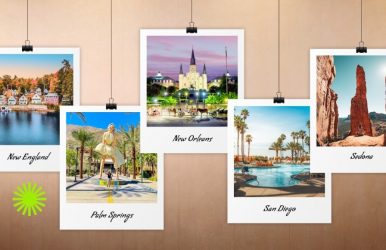
Crisp air! Mild temperatures! Colorful foliage! All these have been the go-to experiences for anyone visiting the USA in November. Now, add to that the declaration from President Donald Trump, marking 11th November as a national holiday. The day commemorates the Armistice Day of World War I. Already known as Veterans Day, the rebranding of November 11th now allows the USA and visitors to adjust their travel plans. The declaration of a new historic holiday always boosts tourism to war memorials and places associated with the specific event. So, from Washington D.C. to Philadelphia Marine Barracks, the travel scene in the USA in November is going to get busier. Furthermore, with Thanksgiving Day approaching on 27th November this year, it seems like the perfect time to plan a holiday in the USA. Now, what kind of traveler are you? Do you want warmer escapes, cultural encounters, fall colors, or the quintessential autumn festive spirit in November? I will share the best with you, and no wonder, you will find many of the best places to visit in November, in common with our October favorites. How I Have Chosen The Best Places To Visit In November In The USA? Map + climate zones: A U.S. map colored by “mild, cool, snow-likely” zones in November I have considered five key points in choosing the best places to visit in November in the USA. An assessment of mild, cool, and snowy-like zones in November. Differences in the early vs. late November weather conditions. Considering the amount of daylight in the specific regions and the availability of outdoor attractions. Budget and cost expectations. Autumn Colors Criteria for Best Places to Visit in November PlacesMild Weather Conditions • Florida • Savannah • New Orleans Cool Weather Conditions • San Diego • Phoenix • San Antonio • Palm Springs Snowy-Like Conditions • Flagstaff Early November Visits • SedonaLate November Visits • Maui Longer Daylight in November • Las Vegas Budget-Friendly Places to Visit in November • Glacier National Park • Boston Autumn Colors • New England What Are The Best Places To Visit In November In The USA (Based On The Criteria Discussed) Here are my favorites for visiting the best places in the USA in November. You can vote for your favorite now. 1. Mild Weather Conditions Want to explore the warmer places to visit in November? These are places where you can be. • Florida Temperature in November: 13-25 °Celsius Top Seasonal Activity in November: Miami Book Fair International, Manatee Viewing and Swimming in the Crystal River, St. Augustine's Nights of Lights, Cortez Stone Crab & Music Festival Florida is the home of the Crystal River, and November is the Manatee season. Furthermore, it is the best time for wildlife viewing in the Everglades National Park. Moreover, you can plan a trip to John Pennekamp Coral Reef State Park in Key Largo and enjoy snorkeling. • Savannah, Georgia Temperature in November: 12-21 °Celsius Top Seasonal Activity in November: The Savannah Lighted Boat Parade, SCAD Savannah Film Festival Forsyth Park, Davenport House Museum, and the Cathedral of St. John the Baptist are some of the best places to visit in Savannah in November. However, for moments of solitude, you can visit the Bonaventure Cemetery. • New Orleans Temperature in November: 12-22 °Celsius Top Seasonal Activity in November: Bayou Bacchanal, celebrating Caribbean culture, Tremé Creole Gumbo Festival at Louis Armstrong Park The Garden District or the French Quarter are the best places in New Orleans to soak in the autumn vibe. Furthermore, don’t miss the coffee and beignets at Café Du Monde. 2. Cool Weather Conditions The following places are cool and comfortable in November. However, you will feel the nip in the air. • San Diego, California Temperature in November: 13-21 °Celsius Top Seasonal Activity in November: Watching Fall Foliage at the Japanese Friendship Garden and Balboa Park, Whale Watching Tours November in San Diego is the month to revel in the Craft Beer Festival and taste the best beers from local breweries. It is also the ideal time to try the local wine, ceviche, and oysters. • Phoenix, Arizona Temperature in November: 10 to 24 °Celsius Top Seasonal Activity in November: Phoenix Veterans Day Parade (the largest in the Country), Phoenix Pizza Festival The Desert Botanical Garden is the best place to visit in Phoenix in November. The garden hosts the ZooLight or a Festival of Lights this month. Furthermore, the November weather is ideal for golfing and hot air balloon rides in Phoenix. • San Antonio, Texas Temperature in November: 9-22 °Celsius Top Seasonal Activity in November: Ford Holiday River Parade and Lighting Ceremony The River Walk in San Antonio is the epicenter of fall festivities. Furthermore, San Antonio is one of the most celebrated locations in the country for the Day of the Dead. • Palm Springs, California Temperature in November: 11-25 °Celsius Top Seasonal Activity in November: Greater Palm Springs Pride for LGBTQIA+ Community, Veterans Day Parade, Props & Hops Craft Beer Festival Palm Springs in California is one of the most coveted locations for travelers from the LGBTQIA+ community. Furthermore, in November, it becomes a foodie’s paradise with the Palm Springs Food & Wine Festival. 3. Snowy-Like Conditions Flagstaff is the best place to visit in the USA in November if you want to experience snowy-like conditions. Temperatures fluctuate throughout the month of November in Flagstaff, and the temperature ranges between -5 and 10 degrees Celsius. As an International Dark Sky City, Flagstaff is the ideal place for stargazing at Lowell Observatory in November. Also, you can explore the local art scene by being a part of the First Friday ArtWalk on the first Friday of November. 4. Early November Visits Sedona and New York are my favorite picks for early November visits. • Sedona, Arizona Temperature in November: 4-18 °Celsius Top Seasonal Activity in November: Sedona Annual Turkey Trot Fall in Sedona is beautiful, with hiking in the Oak Creek Canyon and driving through the 89A route. While hiking and driving, you will see the most gorgeous fall colors. Furthermore, a drive through the SR 179 route is another great choice to see the fall foliage. Moreover, as a certified International Dark Sky Community, Sedona is ideal for stargazing in November. 5. Late November Visits Are you visiting the USA around the Thanksgiving Day festivities? These are the places you can visit. • Maui, Hawaii Temperature in November: 19 to 27 °Celsius Top Seasonal Activity in November: Humpback Whale Watching With places such as Turtle Town and Molokini Crater, Maui is ideal for snorkeling in November. You can also try surfing at Ho'okipa Beach. 6. Longer Daylight in November The sunshine hours start becoming shorter from mid-November to late November, and Las Vegas is the place you must visit for longer sunshine hours. Las Vegas experiences temperatures ranging from 5 to 19 degrees Celsius in November. Furthermore, the Ice Rink at The Cosmopolitan, Downtown, and the LINQ Promenade are some of the best places to visit in November in Las Vegas. 7. Budget-Friendly Places To Visit In November Visiting the USA in November on a budget? Visit the following destinations. • Glacier National Park, Montana Temperature in November: -3 to 4 °Celsius With the first snowfall in November, Glacier National Park transforms into a snowy wonderland. Furthermore, the golden leaves of the larch trees in the park look stunning against the backdrop of white snow. • Boston Temperature in November: 4-11 °Celsius Boston bustles with energy in November, with the Holiday Market at Snowport offering the best shopping experience. Furthermore, ice skating at the Frog Pond, enjoying a stroll along the Freedom Trail, and seeing the fall foliage are the best seasonal attractions in Boston in November. 8. Autumn Colors New England is the most picturesque location to visit in the USA throughout the autumn season. The temperature in the region varies between 0 and 7 degrees Celsius. Furthermore, Plymouth in Massachusetts is the first site of Thanksgiving. It is the venue for America's Hometown Thanksgiving Celebration. Moreover, Vermont is the crown jewel in autumn tourism in the USA, with the most vivid display of fall foliage.What Are The Best Places To Visit In November In The USA? A 7-Day Itinerary While it is logistically impossible to cover all the locations listed within a month, forget 7 days; you can focus on specific zones, such as the Southwestern regions like California (mild weather conditions) or the Southeast Cities (for cultural exploration). Table 1: A 7-Day November Vacation Itinerary In The Southwestern Region/California, Arizona, And Nevada Days Destination Activities/Focus Estimated Drive Time Day 1 San Diego, CA • Arrival in San Diego• Exploring Balboa Park• Visiting the San Diego Zoo• Beach Vacation at Coronado and La Jolla N/A Day 2 Palm Springs, CA • Driving to Palm Springs• Explore the Downtown• Visit the Art Galleries• Relax by the pool 2-3 Hours Day 3 Sedona, AZ • Drive through the Red Rocks of Sedona.• Go for a hike on the Airport • Mesa Trail in the afternoon.5-6 Hours Day 4 Flagstaff, AZ • Drive to Flagstaff.• Visit Lowell Observatory. • Hike to Humphreys Peak, the highest natural point in Flagstaff.2 Hours Day 5 Las Vegas, NV • Drive to Las Vegas.• Try your luck at the Casinos.• Have the best food in Nevada.4-5 Hours Day 6 Phoenix, AZ • Drive from Las Vegas.• Visit the Old Town Scottsdale. • Spend the afternoon and evening in the Valley of the Sun. 5 Hours Day 7 Leaving Phoenix • Take the return flight from Phoenix.N/A Table 2: A 7-Day November Vacation Itinerary In The Southeastern Region/ Florida, Georgia, And Louisiana A Calendar Of November Festivities In The USA Here is a list of local and nationwide observances and celebrations in November in the USA. Dates of Important Festivities/Celebrations in November Festivals/Observance Significance Date in 2025 1st November All Saints' Day Christian Religious Festival N/A 1st-2nd November Día de los Muertos (Day of the Dead) Important for people of Mexican heritage 2nd November Month-Long Festivity Native American Heritage Month Celebrates the history and contributions of indigenous people N/A Month-Long Observance National Adoption Month Promotes child welfare and adoption N/A 11th November Veterans Day and now the Armistice Day of World War I • Honors military veterans and commemorates the victory of World War I.N/A Fourth Thursday Thanksgiving Day • Family feasting • Parades Macy's Thanksgiving Day Parade in NYC 27th November Day after Thanksgiving Black Friday • Marks the Holiday Shopping Season28th November Things To Keep In Mind For Visiting The USA In November Weather conditions vary massively across various regions in the USA in the month of November. So, here are the things you need to keep in mind. Regions Weather Conditions/Things to Keep in Mind Midwest and New England • Cold Temperature • Possibility of Snow • End of Fall Foliage • Pack Warm ClothesMid-Atlantic/Central States, such as New York • Chilly Weather • Great for Outdoor Activities • Wear a Long Coat Southern Destinations/Florida, Hawaii, Southern California, Key West • Mild Weather • Popular for Sun Break in Late November Mountain/Ski Regions such as Lake Tahoe, Utah, and Colorado • Mountain Resorts Gear up for Ski Seasons Check out the Opening and Early Snow Deals Moreover, despite November being a quieter month, in comparison to the summer season, during the Thanksgiving Day celebration, there is a rise in the number of visitors to the USA. So, the airports and parking lots are going to get busy. Furthermore, many roads and natural attractions remain closed or partially accessible from mid to late November thanks to the onset of snowfall and ice. For example, the following places remain closed due to snow Glacier National Park in Montana Trail Ridge Road of the Rocky Mountain National Park in Colorado Glacier Point Road and the Tioga Pass Road of the Yosemite National Park in California For updates on the accessibility of the national parks, you can check out the updates on the National Park Official Website. What Are The Best Places To Visit In November? Frequently Asked Questions (FAQs) Here are the frequently asked questions and answers about the best places to visit in the USA in November. 1. Where Is The Best Weather In November In The USA? The weather conditions in the USA vary across regions in November. However, Florida, Savannah, and New Orleans are some of the best places if you are looking for mild weather conditions.Also, for snowy conditions, you can visit Northern New Mexico and Flagstaff. 2. Is November A Good Time To Visit The USA? Yes, November is a good time to visit the USA. Being in the shoulder season, November does not have the crowd of summer.Furthermore, the fall colors, mild weather conditions, and festivals such as Thanksgiving Day make November an ideal month for a trip to the USA. 3. Where Is The Most Romantic Place In The USA? Maui is the most romantic place in the USA. In a recent survey report conducted by FunJet Vacations, Maui has dethroned Paris, the City of Love, as the most romantic destination in the world.The landscape of Maui is beautiful, and it has pristine beaches. Moreover, Maui is an Instagrammable location for its amazing sunset views. 4. Where To Go In November With Family? Maui, San Diego, and Orlando are some of the best places to visit with Family in November. Furthermore, if you are in the USA for the Thanksgiving Day celebration, New York City is the best place to be.Be a part of the Macy's Thanksgiving Day Parade in New York City. Read Also: How To Get To The Edge Of The World Arizona? Navigating The Route What Are The Best Places To Travel In October In The USA? Plan The Best USA Vacations In Fall Where Is Nusa Penida Island? (With Location, Direction, Why Is Nusa Penida Famous, And What’s Going On)