


 Related
Must See Places In New York | Can You Guess The Names | New York Makes A Comeback
BY Mashum Jan 30, 2020
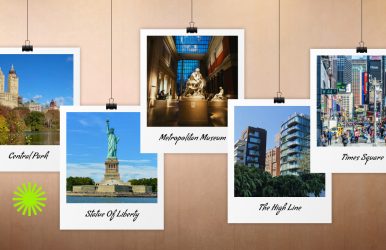
With a change in tourist behaviors, New York is all set to exceed the tourism records of pre-pandemic days. This upward graph in tourism numbers has been visible since 2023. In the same year, footfalls in New York crossed the 62 million mark. Now, regarding the must see places in New York, the iconic ones like the Statue of Liberty, the Metropolitan Museum of Art, and the High Line continue to cast their charm. However, breaking the tourism lulls of the pandemic days, tourists are now eager to explore beyond Manhattan. Further, they want to experience the “Real New York City,” away from maddening crowds. So, in this Tour and Travel guide, I have highlighted the most popular destinations in New York, along with some unique hotspots. It’s like the Frank Sinatra song, “I want to be a part of it, New York, New York Your vagabond shoes, they are longing to stray And step around the heart of it, New York, New York…” Must See Places In New York | Iconic Landmarks In New York New York remains a dynamic hub for tourism, with a significant increase in visitors and visitor spending. In 2024, the number of tourists to New York City was close to 65 million, which was the second-highest number in the city’s history. “With nearly 65 million visitors this year — the second highest figure in our city’s history — New York City has once again solidified its position as the premier destination in the nation and one of the top travel spots in the world.”Eric Adams, Mayor, New York City So, the city is ready to make a massive economic recovery, with the tourism sector making a strong and steady comeback. Further, the following must see places in New York remain the heartbeats of the city’s tourism. 1. Central Park | A Quiet Retreat Amidst The Bustling New York City Embed: https://www.instagram.com/p/C5WYDY2IRu0/ Entry: Free Hours Open: 6 AM to 1 PM Christo and Jeanne-Claude’s “The Gates” is making a comeback to Central Park. I was just checking out the Central Park Conservancy website and was elated to find that this transcendental art installation in saffron hue is once again ready to tell the tales of a park reborn. The Shed, a non-profit cultural organization, will be hosting an exhibition called “Christo and Jeanne-Claude: The Gates and Unrealized Projects for New York City.”This exhibition will open on 12th February 2025, marking the 20th anniversary of “The Gates.” Once home to the Indigenous Lenape people, Central Park became what it is today with the craftsmanship of Calvert Vaux and Frederick Law Olmsted. Walking, e-scooter tours or biking through the trails are the best ways to explore the manicured, yet natural-looking vistas of the park. Moreover, Central Park is full of attractions, including the Strawberry Fields, a tribute to John Lenon, the Conservancy Garden, Bow Bridge, Belvedere Castle, etc. 2. The Statue Of Liberty | The Symbol Of Freedom Entry Fee: Free Ferry Charges: Free for Children below 4 Years, $16.50 for Children Aged 4-12, $25.50 for the Age of 13+, $22.50 for Seniors (62+) Hours Open: 9 AM to 5 PM The Statue of Liberty was a gift by France, built-in 1886. It is among the most popular symbol of freedom and one of the greatest icons in America. Standing at 152 feet tall, it is one of the tallest statues in the world and weighs around 450,000 pounds. Battery Park offers a great view of the statue from the land. However, the best way to see this statue is by taking a short ferry trip to Liberty Island. You can get up close, take a stroll around the ground and pedestal. And, if you make advanced reservations, you can even go up to the crown. When you take the ferry, you will also stop at Ellis Island and can explore the Immigration Museum. 3. Metropolitan Museum Of Art | Housing 5000 Year Old Artwork Entry Fee: $30 for Adults, $22 for Seniors and Visitors with a Disability, $17 for Students, Free for Children below 12 Years Hours Open: Monday, Tuesday, Thursday and Sunday - 10 AM to 5 PM, Saturday and Sunday - 10 AM to 9 PM, Wednesday - Closed Metropolitan Museum of Art, also famously known as MET, was established in 1870. It is one of the most popular museums in the United States of America. The center has an extensive collection of over 2 million artworks, some of which date back to 5000 years. It has three sites. However, Met Fifth Avenue is the centerpiece of the museum. If you are a fan of art and history, this is a place that you should not miss out on. American arms and armors, decorative arts, Egyptians arts, photographs, musical instruments, etc. are some of the many items that you get to explore here. 4. The High Line | The Changed West Side Elevated Line After An Ideas Competition High Line was once a rail line, which has now become a popular tourist attraction of the city. The rail line has now been transformed into a walking trail over the city streets. The linear public park has a wide range of trees and plants. Further, The High Line, or the linear public park, has a wide range of trees and plants. The High Line you visit today survived a demolition order from Mayor Giuliani in 1999. However, four years later, the “ideas competition” hosted by Friends of the High Line highlighted the potential of this “ugly eyeshore” to get transformed into one of the must see places in New York. So, today, the 1.45-mile-long greenway with over 500 species of plants reminds me of the headline on the front page of the New York Times. It read, “Frog of a Railroad to Become Prince of a Park.” Moreover, glass railings line the park, which gives it a more natural feel. From here, you get an amazing view of the bustling city of New York. You can access the high Line on different points from Gansevoort to 34th Street. Some of the access points only provide stairs, whereas others have elevators as well. 5. Times Square | At The Crossroads Of The World Exhibiting tall, bright billboards and displays, Times Square is one of the must-visit places in New York. While it is exciting at any time of the day, it truly livens up in the evening. This is the site where New York celebrates its New Year's Eve and where the Ball Drop happens at midnight. It is a busy street, which is always crowded with people, but still has a unique character to it. Bleachers are installed on the other end of where you can sit and admire the hustling scene. Time Square got its name in the year 1904, and before that, it was known as Longacre Square. Also, if you are looking to find the best food trucks in NY, then I would recommend visiting vstreetfood.com/food-trucks/new-york/. New York is considered the city that never sleeps, and it is true. No matter what time of the day it is, there is something you can do or explore here. Above are some of the places that you must visit in New York. And while you explore these destinations, you will come across a bunch of others on your way because they all are closely connected. Also, when in Times Square, you must not forget to explore the best food trucks in NY, especially vstreetfood.com/food-trucks/new-york/. The Must See Places In New York | Hidden Gems You Will Fall In Love With As promised, here, I will discuss some hidden gems in New York. These must see places in New York are eclectic and they represent the true spirit of the city beyond the glitz and glamor of Manhattan. Here we go! Theodore Roosevelt Birthplace National Historic Site https://www.instagram.com/p/DBo43aGy2u9/?img_index=1 Hours Open: Wednesday – Sunday:10:00 AM to 4:00 PM Entry Fee: Free Theodore Roosevelt Birthplace National Historic Site is the boyhood home of the first US president born in the USA. Today, this historic site offers a 45-minute tour guided by a ranger or volunteer. Stone Street Historic District In the Financial District of Manhattan, Stone Street has created a world of its own. This cobblestone street or the Stone Street is one of the oldest in New York and a simple stroll through it is an experience for the dark academia fans. Further, Stone Street will take you back to 1658, when the residents of the area petitioned this street. Museum At Eldridge Street https://www.instagram.com/p/DEN06khzba7/?img_index=1 Hours Open: Sunday - Friday: 10 AM – 5 PM, Saturday: Closed Entry Fee: Adults: $15, Students & Seniors: $10, Children 5 - 17: $8, ‘Pay What You Wish’ (Mondays and Fridays) Located in the historic Eldridge Street Synagogue, the Museum At Eldridge Street symbolizes the realization of immigrant dreams. The Eastern European Jewish immigrants built this synagogue in 1887, and it was the first grand synagogue (purpose-built) in the USA. Today, the museum stands out with its architectural excellence and unique exhibits. Morgan Library https://www.instagram.com/p/DDSHkw8o6um/?img_index=4 Hours Open: Tuesday, Wednesday, Thursday, Saturday, and Sunday from 10:30 Am to 5 PM, and Friday from 10:30 AM to 8 PM Entry Fee: Free for Children below 12, $13 for Students, $17 for Seniors, $25 for Adults The Morgan Library and Museum is a treasure trove of rare books, prints, manuscripts, and prints. Located in Madison Avenue, the library and museum has an opulent setup with the collections of financier Pierpont Morgan. Ground Zero Museum Workshop https://www.instagram.com/p/CTwub4yLFU1/?img_index=1 Hours Open: Thursday, Friday, and Saturday: 12:30-2:30 PM, Sunday: 1-2:30 PM, Wednesday: 1:30-3:15 PM, Monday and Tuesday: Closed Entry Fee: Children (Ages 4-12) - $25.00, Adults (Ages 12+) - $32.00, Seniors (Ages 65+) - $25.00 Ground Zero Museum Workshop is the best place to find the most realistic account of the Ground Zero “Recovery Period.” You will find images, artifacts, and 100s of exhibits to take you through what happened at Ground Zero and how everyone recovered from that. Further, today, the Ground Zero Museum Workshop is one of the best places for dark tourism in the USA. Read Also: 12 Things That Everyone Should Try In Mexico 5 Backpacking Tips for an Unforgettable Euro-Trip