


Free And Cheap Things To Do In Phoenix, Arizona | Phoenix Travel Guide On A Shoestring

Nov 21, 2024

Last Updated on: Jul 2, 2025

Travel Guides

People love Arizona, and our economy is growing because of it. Tourism supports critical services for Arizonans, and our work to build an Arizona for everyone translates to more visitors and more jobs for our great state.” Katie Hobbs, Governor of Arizona.

You will find an echo of the governor’s words in the statement shared by Lisa Urias. She is the CEO of the Arizona Office of Tourism. She has mentioned that Arizona’s diversity, amazing beauty, and hospitality are behind the growth of the tourism industry in the state. 

Now, there is enough market data to corroborate the claims of the governor and the CEO of the Arizona Office of Tourism. In 2023, 86% of the tourists in Arizona were repeat visitors, and the $1.15 billion tourism tax collected in 2023 was 10% of the state’s operating budget. 

Phoenix, of course, plays a crucial role in the state’s tourism development. Along with unique desert beauty, Arizona has the best urban landscapes and the warmth of southwest culture. 

In addition, the cheap and free things to do in Phoenix, Arizona, make the city a popular tourist destination. 

So, do you want an overview of Phoenix, Arizona’s free and cheap tourist attractions? Let’s explore. 

You Can’t Miss These Free And Cheap Things To Do In Phoenix, Arizona

You Can’t Miss These Free And Cheap Things To Do In Phoenix, Arizona

Phoenix, Arizona, has a pricey vibe. However, don’t be fooled by that vibe as a tourist. Participating in cultural activities is one of the best things to do in Phoenix, Arizona, for free. Also, people in Arizona are perennially in love with outdoor activities. 

You just need to set your itinerary right to enjoy a mix of outdoor pursuits, cultural tours, and more. 

Did You Know?

Phillip Duppa, an Englishman, was a friend of Jack Swilling. Now, Jack Swilling was one of the city’s founding fathers, and Phillip Duppa named the city Phoenix.

The city was named to symbolize rebirth. The idea was that  Phoenix would rise from the ashes of the natives and it would become prosperous in the land of irrigation. 

1. Explore The Heritage Square

Downtown Phoenix bustles with modern vibes. However, Heritage Square is a place that complements its modern vibes with its old-world charm from the Victorian era.

Also, the Heritage Square is known as the “National Register of Historic Places.” Many of the buildings here are restored, and exploring the interiors of these buildings is one of the cheapest but meaningful things to do in Phoenix, Arizona. 

For example, the Rosson House Museum stands here, and you just need to pay a fee of $15 for admission. 

Heritage Square, Phoenix, Buildings
The Burgess Carriage HouseThe Thomas HouseThe Stevens HouseThe Burgess Carriage HouseThe Rosson House Musuem, etc. 

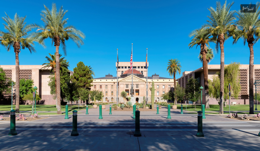
2. Visit Arizona Capitol Museum

Visit Arizona Capitol Museum

Open Monday through Friday, 9 AM to 4 PM, Saturday, 10 AM to 2 PM

With an “Entry is Always Free” promise, the Arizona Capitol Museum is a big draw in the state. Let me put it directly. If you want to know about the history and culture of the state, you have to visit the Arizona Capitol Museum.

The museum also offers in-depth insight into the state’s political scenario. 

Further, if you plan to visit Arizona in a few days and have included a visit to the Arizona Capitol Museum as one of the best things to do in Phoenix, Arizona, you must not miss the new Merci Train Exhibition.

The museum now celebrates the 75th anniversary of the train’s arrival. Some of the most prominent exhibits at the museum are:

  1. USS Arizona: Flagship of the Fleet
  2. Arizona Takes Shape
  3. The Struggle for Universal Sufferage – Voting Rights Timeline
  4. The U.S.S Arizona Artifact Collection, etc. 

You can even be a part of the “Arizona Capitol Museum Guided Tour Survey” for educational purposes. 

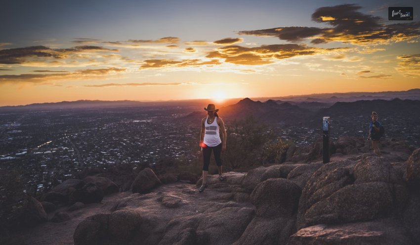
3. Hike At Camelback Mountain

Hike At Camelback Mountain

Before I get into the details of hiking at Camelback Mountain, I must tell you that it’s difficult and very strenuous. So, if you are not a seasoned hiker at the peak of your fitness, this is not one of the best things to do in Phoenix, Arizona, for you.

Still, Camelback Mountain and its Cholla and Echo Canyon trailheads have millions of visitors every year. The current trailhead hours are from sunset to sunrise. 

Further, this 2704 feet mountain gets its name from its double humps. Its terrains are uneven with boulders, and the elevation gains are difficult to cope with.

However, once you reach the summit, you will get the best views of the Valley of the Sun. 

Tour And Travel Highlight

Camelback Culture Community, led by Jes Dobbs, is a local group of hikers. Under the leadership of Jes Dobbs, a graphic designer, the group is making an effort to make Camelback Mountain safer.

They have launched a timely petition to improve the safety of the mountains in time, considering the death and rescue of three hikers from the Echo Canyon Trail. All of them died due to heat exhaustion.
Phoenix experienced record heat waves this season, and the rising temperatures were additional perils for the hikers.

Nevertheless, the Camelback Culture Community has made two demands in their petitions.
Extension of Trail Hours ( With An Extended Timing Of 4 AM to 8 PM)Installation of Automated Gates At The Trailheads of Camelback and Other Mountains

The petition already has 1,900 signatures and in the words of Jes Dobbs,

“I believe having trailheads with year-round, consistent opening and closing times will enable locals and visitors to hike in the cooler hours of the day legally and when their lives allow. 
Many hard-working people don’t have the option to take a midday hike. They deserve access to exercise and nature during their limited free time – before and after work.

4. Visit Phoenix Art Museum

Visit Phoenix Art Museum

Thanks to the “Pay-What-You-Wish Wednesday,” visiting the Phoenix Art Museum is one of the cheapest things to do in Phoenix, Arizona. Your entry fee is voluntary after 3 PM. 

Further, the evening sessions or AfterHours are free, and you can enjoy entertainment events and live music. You can attend these events four times a year. 

Family FunDays is another great event to visit the museum for, and it happens four times a year. These events take place on Sundays, and on these days, you can enter the museum for free and attend events for all ages. 

Tour And Travel Tip

The Western Gallery is the highlight of this museum. Here, you will find artwork from the pioneers and some exemplary works by the modernists. 

One thing is common in all these artworks. They show the prominent influence of the beautiful landscape of Arizona. 

5. Visit The Historic Heard Museum

Does the life of American Indian tribes in the Southwest part of the country intrigue you? The Historic Heard Museum is your go-to destination. Along with the life of the tribes, you will also get to know about their culture and art.

When you are at the Historic Heard Museum, the following are going to be your highlights. 

  • Films
  • Ethnographic Displays
  • Kids’ Exhibit

However, for me, the main attraction at this museum is Hopi Kachinas. It is an unbelievable collection of spirit dolls. Most of the dolls are gifts from Barry Goldwater, the  Presidential nominee. 

Visiting the Historic Heard Museum is one of the best things to do in Phoenix, Arizona. For free entry, you can plan a visit to the museum on the first Friday of every month (except March). The museum operates between 4 PM to 8 PM.

Furthermore, Indian fairs, hoop dancing, and competitions are some popular events taking place in the museum. 

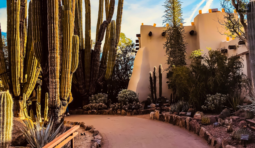
6. Visit The Desert Botanical Garden

Visit The Desert Botanical Garden

Entry to Desert Botanical Garden in Arizona is free on the Community Day or every second Tuesday of the month. Spanning over 55 acres, this botanical garden has flowers, cactus, and trees from across the globe.

The best time to visit the botanical garden is between March to May. During these months, you will find Mexican gold poppies and bluebells in full glory throughout the Desert Wildflower Loop Trail. 

The garden is well-maintained. Also, as you visit the desert denizens arranged according to theme, you learn a lot about the desert plantation. 

Tour And Travel Tip 

You have to book the tickets for Desert Botanical Garden in advance if you want to pay a visit on Community Day.

7. Take A Walk In Art Walk

Phoenix has the “First Friday Art Walk” on the first Friday of the month between 6 to 10 PM. It is one of the biggest self-guided art walks in the city. Further, you can take the light rail plying through downtown Phoenix and connecting to various art districts of Phoenix. 

Also, as you explore the art spaces, galleries, and event venues of the city, you become familiar with the local vibe. 

Artlink, a nonprofit organization, started this art walk, and it is still the organizer of the event. Today, this free art event has become the uniting space for people of all age groups.
Artists, vendors, and musicians take part in this event to soak in the cultural vibe of Downtown Phoenix. 

To explore the best free and cheap things to do in Phoenix, Arizona, you need to find comfortable accommodation first. The table below has the names and details of the best hotels in Phoenix, Arizona. 

Hotels In Phoenix, ArizonaPhone Number
DoubleTree by Hilton Phoenix North+1 602-997-5900
Great Wolf Lodge, Scottsdale+1 480-948-9653
Best Western North Phoenix Hotel+1 602-395-0900
Hotel Valley Ho+1 480-376-2600
The Clarendon Hotel and Spa+1 602-252-7363
The Scottsdale Resort and Spa, Curio Collection by Hilton+1 (480) 991-9000
Arizona Biltmore, LXR Hotels & Resorts+1 602-955-6600
Embassy Suites by Hilton Phoenix Scottsdale+1 602-765-5800
Fairmont Scottsdale Princess+1 480-585-4848

Also read

Share on Social Media

Sibashree is a travel, culture, and leisure writer who has been writing since the age of 12 and professionally since 2014. With more than a decade of travel writing experience and journeys across India and several parts of the world, she brings a deeply personal and thoughtful perspective to her work. A student of English Literature and Mass Communication, Sibashree has always viewed travel as more than movement — for her, it has been a way of understanding people, cultures, and herself. Her passion for spiritual exploration has also led her to many unusual and meaningful destinations over the years. Outside of writing, Sibashree enjoys watching European cinema, reading about global politics, and reflecting on the stories hidden within everyday places.

Leave a Reply

Your email address will not be published. Required fields are marked *

title-img Related

READ MORE

The Role Of Self Storage In Extended Cruise Travels

BY  Barsha Jan 19, 2024

Secure storage of travel documents and valuables is a crucial aspect for frequent travelers. Even for expatriates, or those embarking on long-term journeys. The safety of items like passports, visas, legal papers, and sentimental valuables is paramount. As their loss or damage can lead to significant inconveniences or disruptions. Self-storage units provide an ideal solution, offering a secure and accessible space to store these critical documents. With the increasing mobility of people in a globalized world, the demand for such storage solutions has risen. These units ensure that important documents are protected from theft, loss, and environmental damage while the owners are traveling. This introduction delves into the strategies and benefits of using self-storage units for safeguarding travel essentials.It highlights how they can provide peace of mind for travelers! It is through keeping their most important documents and valuables safe and sound. Choosing The Right Storage For Travel Documents Selecting the appropriate storage facility for travel documents requires careful consideration to ensure maximum security and preservation. The ideal storage solution should offer a combination of robust security features and an environment conducive to preserving paper-based documents. Key factors to consider include climate control to prevent damage from humidity and temperature fluctuations. The strong physical security measures to safeguard against theft or unauthorized access. Facilities like Northwest Self Storage units typically provide these essential features. It makes them a suitable choice for storing sensitive travel documents. Additionally, the location of the storage unit is a vital aspect. It especially for travelers who may need quick access to their documents. It's important to choose a storage provider that balances convenience with high security, ensuring that travel documents are both safe and accessible when needed. By carefully selecting a storage unit that meets these criteria, travelers can have confidence that their important documents are securely stored and well-preserved, ready for their next adventure. Best Practices For Storing Valuable Papers Storing valuable travel documents such as passports, visas, and other critical papers requires adherence to best practices to ensure their longevity and safety. The following are key guidelines to consider: Use Acid-Free Folders: Store documents in acid-free folders to prevent deterioration. Maintain a Dry Environment: Protect papers from moisture-related damage. Avoid Direct Light: Store documents away from direct sunlight to prevent fading. Keep in a Secure Location: Use a locked cabinet or safe within the storage unit. Regular Checks: Periodically inspect the documents for any signs of damage. For more information on preserving important documents, resources from the Library of Congress provide detailed guidance. By following these best practices, travelers can be assured that their valuable papers are stored under optimal conditions, minimizing the risk of damage and loss. Proper storage not only preserves the physical state of these documents but also ensures that they remain accessible and intact for future travel needs. Digital Backup Of Important Travel Documents In today's digital age, creating electronic backups of important travel documents is as crucial as physical storage. This process involves scanning or photographing passports, visas, insurance policies, and other vital papers, and storing the digital copies in a secure, accessible online location. Digital backups serve as a safeguard against the loss or damage of physical copies and provide an additional layer of security. They can be lifesavers in situations where the original documents are inaccessible due to unforeseen circumstances during travel. The key to effective digital document storage lies in choosing secure and reliable cloud storage services, where data encryption and privacy settings are paramount. Additionally, it's wise to have these digital copies accessible through multiple devices, including smartphones and laptops, ensuring they can be retrieved whenever necessary. However, it's important to balance accessibility with security, ensuring that sensitive information is protected from unauthorized access. Adopting this dual approach of physical and digital storage not only ensures the safety of travel documents but also provides peace of mind to travelers, knowing they have immediate backups available in any situation. Accessibility And Retrieval Of Stored Items Ensuring easy accessibility and retrieval of stored travel documents is essential for travelers who may need to access their papers quickly. Here are a few steps to optimize the accessibility of stored items: Strategic Organization: Arrange documents in a logical order, perhaps by type or frequency of use, to quickly locate what you need. Clear Labeling: Label each storage box or folder clearly, detailing its contents for easy identification. Access Procedures: Establish and familiarize yourself with the storage facility's procedures for accessing your unit, especially outside standard hours. For detailed guidelines on organizing and accessing important documents, the National Archives provides valuable resources. By implementing these steps, travelers can ensure that their documents are not only safely stored but also readily accessible when needed. This organization is particularly important in emergency situations or unexpected travel changes, where quick access to travel documents can alleviate stress and facilitate smoother travel experiences. Combining Physical And Digital Security Measures To maximize the safety of travel documents, combining physical storage with digital security measures is paramount. This dual approach ensures comprehensive protection against a range of risks. In physical storage, using secure self-storage units with robust locks and controlled access is essential. For digital security, employing encrypted cloud services to store digital copies of documents provides an additional layer of protection. Ensuring The Safety Of Travel Essentials In conclusion, effectively storing and securing travel documents involves a blend of physical and digital methods. By utilizing self-storage for physical documents and digital platforms for backups, travelers can ensure the safety and accessibility of their essential papers

READ MORE card-img

Welcome To The Pecos National Historical Park: The Land Of The First American Revolution

BY  Sibashree Sep 12, 2024

I stood before the remnants of the South Pueblo walls, looking over the Mission Church on an autumn day last year. Looking at the archaeological site and standing below the blue fall sky, I was transported to the time of the American Revolution.  Further, I could hear the noise of a bustling trade fair with people from the Pecos Pueblo community doing business. However, the historical importance of the park is much beyond its association with the American Revolution. It is also related to the Civil War in New Mexico and the Independence of Mexico.  So, with centuries of human history etched in every corner, the Pecos National Historical Park is an intersection of past tales and nature. To be honest, The Pecos Pueblo and Santa Fe Trail were the biggest highlights for me when I was at the national park.  Therefore, my ode to the park will start with brief accounts of these places. Then, I will talk about the Glorieta Pass, again a site of historical importance in the park. Finally, you will have a quick look at the park's wildlife.  Pecos National Historical Park: A Land Of Historic Wars And Revolutions  The history of human lives in the Pecos National Historical Park goes back to the Preceramic Period or the 11,500 B.C.E. - 600 C.E. However, the Pecos Pueblo site in the park became a prominent place in the history of the American Revolution in the Early Colonial and Pre-Revolt era.  Spanish people started interacting with the Pueblo people. Further, thanks to the Franciscan Missions, the Spanish rule wanted to have command over the economic life and beliefs of the Pueblo people.  Thus, the first seeds of the American Revolution were sown. To combat the oppression of the Spanish people, the Pueblo Revolt took place on 10th August 1680. As a result, the Spanish Government and Franciscan Friars were expelled from the southwest under the leadership of  Po’pay from Ohkay Owengeh. The Spanish Mission Church, built in 1625, was also destroyed in the revolt of 1680.  However, in 1692, the Spanish People further reclaimed the Pecos Pueblo and many other pueblos. Finally, the Pueblo people declined in numbers in 1700. Before, during, and after the first American Revolution, The Pecos Pueblo emerged as an important location with significant events around it!  Further, around 200 years later (1821-1846 C.E.), another site in the park, the  Santa Fe Trail, witnessed travelers, settlers, and everyone else passing through it. The trail was opened in 1821 after Mexico gained its independence from Spain.  The remains of Pecos Pueblo stood there! By the 1830s, the migration of the Pubelo people was complete, and everyone had shifted to the Pueblo of Jemez and continued their traditions.  Moreover, in 1862, there was the “Battle of Glorieta Pass.” On 26th March 1862, this battle between the Union forces and Confederates occurred at a 700 feet elevation.  The Pecos Pueblo Site Today  https://www.instagram.com/p/Cto5MWnS5Oa/ The rise of the Pecos Pueblo site occurred between 1350 C.E. and 1838 C.E. The Pueblo site had two units, the north and south, and could accommodate around 2000 people. Further, it had 1000 rooms. Therefore, Pecos Pueblo thrived as a busy trading center with trade fairs involving people from Rio Grande Pueblos, Plains Nations, the Gulf of Mexico, and the Pacific Coast. The flint arrowheads and shells found here explain the expansive stretch of the route.  Nevertheless, with time, Pecos Pueblo became instrumental in eliminating Spanish oppression and rule. Still, a drop in the trade, Comanche attacks, and diseases deserted Pecos Pueblo. By 1838 C.E., the last resident of the Pueblo had left and joined the Pueblo of Jemez.  Today, the site stands as a relic from the past. However, it is still equally important for archaeologists and historians.  The Santa Fe Trail  Do you know what the Santa Fe Trail marker near Kozlowski's Trading Post says? It says,  Santa Fe Trail 1822-1879 Marked by the daughters of the American Revolution and the Territory of Nex Mexico.  With the independence of New Mexico and the western territories becoming an annexure to New Mexico, the Santa Fe Trail became the route or passage to the westward movement. Naturalists, journalists, travelers, aspirants, traders, and others took this passage as part of the American expansion. Colonel Henry Inman’s “Stories of the Old Santa Fe Trail,” published in 1881, describes the trail well. If you are a history buff, you must read this book well before visiting the Santa Fe Trail today!  “Kozlowski’s Stage Stop and Trading Post” is the highlight of this trail. You can spend some time here to visualize travelers from the past catching some rest after a long journey through the trail. When on the trail, you can explore the remains of the Pueblo and the Mission Church. You can even consider taking a guided tour of the Forked Lightning Ranch.  Glorieta Pass Battlefield Trail  https://www.instagram.com/p/B9xRKctnb3M/ Important Details About the Glorieta Pass Battle1. Reason for Conflict: Union forces and Confederates wanted to control the Glorieta Pass Route through the Sangre de Cristo mountains and the main supply center (Fort Union) for the passage of soldiers and supplies. 2. Contenders: The Confederates, with volunteers from Texas and under the leadership of General Shipley and the Union forces led by Colonel Canby, and soldiers from Fort Union, New Mexico, and Colorado. 3. Battle Begins: March 26, 18624. Reinforcements: 27th March, 18625. Battle Resumes: 28th March, 18626. Battle Ends: 29th March, 18627. Casualty: Death of 375 People 8. Consequence: The Union forces defeat the Confederates as they fail to ruin the Fort Union. Further, the Union forces maintain complete control over Southwest America.  The Glorieta Battlefield Trail is a popular hiking destination today in Pecos National Historical Park. It is a roundtrip loop, and you will have to cover a distance of 2.25 miles to complete your expedition. Further, the unpaved or graveled hiking route makes it moderately difficult for the hikers. In addition, there is an elevation gain of 152 meters.  You have to drive for around 7.5 miles from the main visitor center of the park. You will need to collect a gate code from the visitor center, which is your access code, to open the locked gate in front of the trail.  As you walk through the forest trail, you get to know more about the Civil War in New Mexico. Many infographics are installed throughout the trail, telling you tales from the past. In addition, there are wayside signs and 14 trail markers to explain the history of the battle on this pass in detail.  More About Hiking The Glorieta Pass Battlefield Trail  Time: Around 1 hour Refreshments (Hikers’ Favorites): Pecos Burger at El Maria Bonita (With a lot of meat and a smoky green chilly flavor!) and Chips and Salsa, of course! The Trail Guide you collect from the visitor center already keeps you hooked on the site's history. Indeed, this trail is less about hiking and more about flipping through the pages of the American Civil War in Mexico.  Let’s Hear It From Other Visitors To The Park  “Really nice park. Easy to find and it is free! Inside the visitor center, they had a really great exhibit that followed the pecos overtime. It was super informative and brought a lot more meaning to the actual park. After looking around the exhibit, you can take the trail up and around the park and church. It's amazing that the walls are still there. The view around the park is also beautiful. We spent about 2 hours here.” - Isabelle M. “I really enjoyed this park. My husband didn't care for it but I think it's really amazing what is still here. He thinks it's all recreation and I can't say if it is or not but I know the current Pecos people don't see it that way. It's pretty awesome that it's free to visit and the visitors center has a little museum that's also free! The trail starts near the restrooms. We accidentally started it from the end. But who cares. We saw everything and I recommend checking it out. Native people history is really cool.” - Lydia G. Exploring Wildlife At The Pecos National Historical Park https://www.instagram.com/p/CA-hAl8nrUW/ This historical national park is a hub of wildlife with a 6,500-acre expansion of forests, rivers, grasslands, and streams. The table below enlists the species that call the Pecos National Historical Park their home.  MammalsElk of Northern New MexicoColorado Chipmunk DeerRock SquirrelBirds*Steller’s JayMountain BluebirdBald EagleFish and AmphibiansRio Grande ChubLongnose DaceRainbow TroutBrown TroutNew Mexico Spadefoot ToadWoodhouse ToadTiger SalamanderPlains Leopard FrogReptilesShort-horned LizardNew Mexico Whiptail LizardBull SnakesGarter SnakesPrairie Rattlesnakes You will find the Prairie rattlesnakes along the trails. So, please exercise caution and inform the ranger if you come across one on your way.  A Quick Glance At Some Important Information About Pecos National Historical Park You must quickly look at the important information available about Pecos National Historical Park before you set in. Location: San Miguel County, New Mexico Established: 28th June, 1965 Area: 27 km² Highest Landscape: Truchas Peak, 3990 Meter Visitor Center: Pecos National Historical Park Visitor Center How to Reach: Via State Road 63  Entry Fee: Free Best Time to Visit: Autumn (Early September to Mid October) Also read Why Include Whale Watching In Your LA Itinerary. From Cocktails To Kickflips: Must-Try Activities In San Diego. Kootenay National Park Or The Land Of Ice And Fire (Experiencing Nature’s Game Of Contrasts)

READ MORE card-img

Kootenay National Park Or The Land Of Ice And Fire (Experiencing Nature’s Game Of Contrasts)

BY  Sibashree Sep 12, 2024

No, it’s not the battle of the Starks, Lannisters, and other houses of Westeros. In Canada lies Kootenay National Park, the actual land of ice and fire. The glacier-made canyons and valleys sing the song of the ice, while the hot springs and grasslands keep the “fire” element alive here.  Also, the national park is a hub of ancient fossils, encouraging walks through the fossil trails. Moreover, you can take a scenic drive through the park, rich in Indigenous culture, history, architecture, and cultural landscape.   So, do you want a virtual tour of this Canadian national park? THIS is where your journey begins! THESE Are The Things You Will Do At Kootenay National Park With no cell service available in Kootenay National Park, you can get lost in the wilderness and explore the most fascinating landscape. However, being respectful to the wildlife is a must for this national park. This August, I came across disturbing news while doing my research on Kootenay National Park.  I have been in touch with a local from Radium Hot Springs for quite some time now. He told me that a grizzly bear coming out of Kootenay National Park was almost struck by an SUV on 19th August 2024.  This incident occurred on a busy highway in southeastern British Columbia, and fortunately, the Kia Sportage SUV made its way to the other side safely. Further, it was a lesson on why following the safety guidelines is crucial while driving in and around the Kootenay National Park. On the major routes of Kootenay National Park, you will have to maintain a maximum speed of 56 mph.However, on the minor routes, the highest driving speed limit will be 37 mph.  Also, around one month before the incident, on 24th July 2024, there was a minor fire in the  Sinclair Canyon slopes (near Radium Hot Springs) of the national park. It was called the Berland Ridge wildfire. This fire was under control thanks to a helicopter bucketing water on it. However, outside the park’s southern boundary, there was a blazing fire that was brought under control after pain-stricken efforts.  So, these incidents show how mindful and cautious you need to be while taking part in the following activities.  Hiking In Kootenay National Park (Hikers’ Favorite Trails) The hiking trails in Kootenay National Park are full of elevation gains and losses. Also, today, the national park has more than 70 hiking trails at easy, moderate, and difficult levels.  However, I have curated a few hiking trails in the table below. After interacting with a couple of hikers, I found out that these are the ones most preferred. Name of the Trail Difficulty LevelDistanceLocationHighlightsMarble CanyonEasy1.4 Km with 42 M Elevation Gain Located near Lake Louise, AlbertaHiking, snowshoeing, and running are the favorite activities here.It is a pet-friendly and kid-friendly trail. It is a year-long hiking trail. Stanley Glacier Trail Difficult 10.9 Km with 607 M Elevation Gain Located near Lake Louise, AlbertaSnowshoeing, camping, and hiking are popular activities on this trail.You can take your dog as a company.June to September is the best time to hike this trail. Sinclair Canyon via Juniper Trail Moderate5.8 Km with 291 M Elevation GainIt is close to Radium Hot Springs in British Columbia.You will have to hike through a beautiful cedar fir forest on this trail.The view of verdant Sinclair Canyon Falls and the Columbia Valley from this trail is breathtaking.Marble Canyon to Paint PotsModerate2.9 Km with 110 M Elevation GainRadium Hot Springs (Marble Canyon Parking Lot  - 89 km east of Radium Hot Springs, Paint Pots - 86 Km east of Radium Hot Springs).Explore a good mix of mature and burnt forest throughout the trail.Behold the Vermillion River running parallel to the trail. Floe LakeDifficult10.5 Km with 1,110 M Elevation Gain Near Radium Hot Springs (72 Km East)Backpacking and camping are popular activities on this trail. The trail leads to the Floe Lake Backcountry campground. This popular meadowy trail is known for its views of peaks, glaciers, and the beautiful Floe Lake. Numa CreeksModerate 6.3 Km with 385 M Elevation GainThe trailhead is near the Numa Falls, which is 80 Km east of the Radium Hot Springs. It is a forested trail.The trail leads to heavy avalanche paths in the park.  The hikers’ words about the trails in this national park are quite encouraging. Let’s find out what they are saying about the mesmerizing hiking trails.  “This is a beautiful, deep canyon hike. The trail crosses the canyon multiple times to view the ferocious Kootenay river below. Hiking boots aren't necessary since it is a well-traveled trail.” - Deborah Turcotte on the Marble Canyon Trail  “The trail was mostly dry and in very good condition. No snow on the trail, just a few short wet spots. Trek up is mostly sheltered but a bit chilly and windy in the bowl so bring layers as the temp changes quickly when the sun is behind clouds. Still lots of snow in the bowl. Found one rock with fossils. There are a few small waterfalls on Stanley Peak. Lots of boulders at the base of the bowl to sit and enjoy a lunch and 360 views. An easy to moderate 3-4 hour hike with nice views of Stanley Peak, Storm Mtn, and the Kootenay Valley.” - Sue W on the Stanley Glacier Trail  Kootenay National Park Camping  Kootenay National Park is a wonderful place for frontcountry and backcountry camping. You can even live in oTENTiks and spend some unforgettable days in the park under the sky.  Frontcountry Camping You can camp near the Vermillion, Kootenay, and Simpson rivers. Also, you can find some quiet spots near Radium Hot Springs village.  Summer is the best season for front-country camping in the national park. However, the sites remain crowded. So, you must go for a prior booking.  Further, the daytime temperature in the national park remains between 16-23 degrees centigrade. Still, the temperature at night can drop below 0 degrees centigrade. So, abiding by the camping rules is crucial, and especially, be particular about the things you will have to carry. Moreover, like camping in any national park, here also you have to ensure that you don’t leave any trace behind as you leave the site.  Backcountry Camping Backcountry camping and backpacking are the best ways to explore the wilderness of this Canadian national park. However, you must make a prior booking and carry a backcountry permit if you want to spend some days and nights amidst grizzly bears, black bears, wolves, elks, and cougars.  Further, there are six backcountry camping grounds in the park, five of which are located along the  Rockwall Trail. The  Verdant Creek Trail has the sixth camping ground.  Random camping is not allowed during summer, as protecting the landscape and vegetation is crucial. This restriction applies from May to October.  However, in the winter months, you can do random camping in the designated areas. You will still need a permit for this. As I have mentioned, the Rockwall trail is the most prominent place for backcountry camping in the park. This site is also popular for the presence of various multi-day hiking trails. These trails are: Honeymoon Pass and Verdant Creek Tumbling - Floe The Rockwall  Tumbling - Helmet - Ochre Loop Numa Creek Helmet Creek and Falls Tumbling Creek Helmet - Ochre Junction In the popular backcountry camping areas, the trails are maintained quite well. Further, there will be amenities like food storage cables, food lockers, picnic tables, and tent pads.  Living in oTENTik An oTENTik is a modern fusion of a cabin and a tent. In the park, you will find the oTENTik site on the Redstreak campground’s A loop.  If you stay in an oTENTik, you will wake up amidst nature, and taking a bath at the hot springs will be the most rejuvenating experience. Then, you can explore the nearby hiking trails and gorge on traditional meals cooked in the campfire.  Relaxing At Radium Hot Springs  Beneath the colorful Sinclair Canyon mountains lie the most refreshing hot springs. Further, the mineral-rich water of the hot springs does not have any odor, and you can take a bath with your entire family.  To reach the Radium Hot Springs, you must drive from Banff and Lake Louise for around 1.5 hours. Further, the journey is as interesting as the destination, as you will get to small turquoise lakes, falls, canyons, and bridges over rivers as you drive through the Kootenay National Park. Also, don’t forget to stop at the following locations to make the most of your journey. Continental Divide (The line diving the Pacific and Atlantic watersheds) Marble Canyon Hike Paint Pots Trail Numa Falls Kootenay Valley Viewpoint (It is the place to get the most beautiful view of Vermilion and Mitchell Ranges.)  Olive Lake Trail and Day-Use Area However, the highlight of the journey, of course, is the Sinclair Canyon, where you will also find big horn sheep roaming. As you hike through the Juniper / Sinclair trail, you will get a “bird’s eye view” of Sinclair Canyon.  Further, as you enter the Radium Hot Springs village, you will see an iconic steel horn sculpture. The “Bighorns Public Art Sculpture” was officially unveiled on 7th April 2021. Moreover, Clara Reinhardt, the mayor of Radium in 2021, said,  “We chose something that implies a sense of arrival to Radium, the Columbia Valley, and beyond. We captured the undeniable natural beauty of the curved horns through a Fibonacci spiral—the golden ratio in nature and art.” “We wanted to create a piece of art that speaks to both the history and the future of bighorn sheep in Radium. We captured the undeniable natural beauty of the curved horns through a Fibonacci spiral—the golden ratio in nature and art.” - Adam Meikle (Artist of the Bighorns Public Art Sculpture) Burgess Shale Fossil Hike  The Burgess Shale Fossil Hike in the national park will give you access to Mount Stephen and Walcott Quarry. These are UNESCO Restricted Sites. Further, you will get to see some of the oldest fossils in the world here.  However, in total, you have three routes to explore in the Burgess Shale Fossil Hike. Let’s discuss them in detail.  Walcott Quarry Starting Point: Takakkaw Falls Difficulty Level: Difficult  Elevation Gain: 825 Meters Duration: 11 Hours Return Distance: 22 Kms Walcott Quarry is a classic example of a fossil hike. Also, the top view of the Emerald Lake from here is amazing. Further, you will find Burgess Shale creatures here, which were found in fossilized conditions at the mountaintop in the Yoho National Park.  “The Burgess Shale organisms lived 508 million years ago in a time period that Geologists call the Cambrian, which began at 541 Ma (million years ago) and ended by 485.4 Ma. The first fossil occurence of most animal lineages (at the phylum and class levels) occur in the Cambrian. As a result of this fact, and because the fossils are well preserved, Paleontologists studying the Burgess Shale fossils can deduce a great deal about the ancestory of animal lineages.” The Burgess Shale fossils were discovered at the Walcott Quarry site in 1909 by Charles Doolittle Walcott. 1 Mount Stephen Difficulty Level: Difficult  Elevation Gain: 795 Meters Duration: 7.5 Hours Return Distance: 9 Kms As you hike through the Mount Stephen trilobite beds, you will get to overlook the “town of Field” in British Columbia. Railway workers in the 1880s used to call the town of Field the space of “stone bugs.”  Further, during this trek, you will see trilobite fossils (now extinct and one of the earliest marine arthropods), and the view of the Kicking Horse River from the trail is amazing.  Stanley Glacier Difficulty: Moderate Return Distance: 10 km Elevation Gain: 385 m Duration: 7.5 hours You will start hiking the Stanley Glacier in a fire-swept forest. The forest has lodgepole pine and wildflowers. Further, along your route, you will get to see a turquoise river, waterfalls, and the best view of the Stanley Glacier. Moreover, you will get to see the fossils of hyolithids, sponges, trilobites, and sponges here, and they are from the Eldon Formation.  Cambroraster, an ancient arthropod, and many other species are found in the quarry near the Stanley Glacier. Further, the shell of a Cambroraster looks like the Millennium Falcon spaceship in its shape. Important Kootenay National Park Data At A Glance  Before you start for the Kootenay National Park, don’t forget to have a look at the stats. Location: British Columbia, Canada Established: 21st April, 1920 Area: 1,406 km² Highest Landscape: Deltaform Mountain (3,102 m) Designation: UNESCO World Heritage Site in 1984 (As Part of the “Canadian Rocky Mountain Parks ) Visitor Center: Kootenay National Park Visitor Centre (7556 Main Street East; Radium Hot Springs, B.C.) How to Reach: Via Highway 1 from Banff, AB or Calgary, AB/Via Highway 95 at Radium Hot Springs, BC Also Read Why Include Whale Watching In Your LA Itinerary. Traveling On A Budget: Tips For Affordable Adventures. From Cocktails To Kickflips: Must-Try Activities In San Diego.