


 Related
5 Things To Pack For Your Next Vacation
BY Arnab Jan 23, 2023
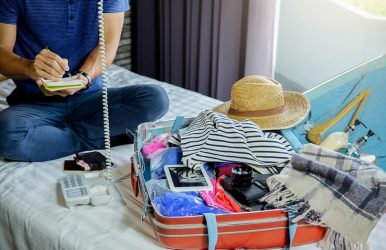
If you have a fun trip coming up, it's important to bring things that will make it a top-notch experience. Different trips will call for different things, but here are some basics that can make a difference for your next vacation, Here Are Five Impotent Things To Pack For Your Next Vacation 1. Entertainment Of course, wherever you may go, you'll be more than entertained by the city and things to do at your destination. But, if you're planning a chill vacation, you may be left with time to lounge around, which means you'll need something to keep you entertained while lying at the beach for hours. Get used books or audiobooks before your next trip to keep your mind entertained, whether you're chilling at the beach or taking a long international flight overseas. If you're a parent traveling with kids, packing entertainment can also be helpful for a smooth and successful vacation experience. 2. Great outfits Going on vacation is an opportunity to go all out with your outfits. You may not be able to wear summer dresses to work, but you can stand out in your favorite dress on vacation. Pack all those fabulous outfits that you wish you could wear more often. Don't forget to include comfortable shoes, especially if you'll be doing a lot of walking. Make sure also to check out the weather conditions expected at your destination so that you can be sure to pack accordingly. From rain gear to summer wear, knowing the climate of your destination will make it easy for you to pack the right clothes. 3. Extra money If you want to enjoy your vacation as much as possible, set aside some extra cash so that you can do all the activities you want to, and spend a little extra on things that you typically wouldn't. Vacation is a time to treat yourself, so make sure you have the means to do so before you board that flight. Apart from making sure you have extra money to spend, set aside some extra cash so that you always have some money on you, just in case something happens with your credit cards while traveling abroad. 4. Your favorite toiletries Because you may not be able to find the toiletries you love and depend on in the destination you'll be visiting, it's essential to pack a toiletry bag with lighter versions of your main staples. Whether you need a specific shampoo or anti-acne product, take care of yourself by packing your favorite travel-size toiletries in your carry-on. 5. Extra space If you have a great vacation planned for somewhere unique, make sure to include extra space in your bag so you can bring home souvenirs and special items from the place you'll be visiting. You can find anything from tapestry to jewelry while on vacation that you wouldn't find at home, and with extra space in your bag, you don't have to feel concerned about being able to bring it back. Think ahead when packing so you can leave out some things that you may be able to buy at your destination. In Conclusion From books to comfortable shoes, there are plenty of things that you'll want to pack for a successful vacation. You will also want to bring your favorite travel-size toiletries and pack the best outfits so you can look your best on your next adventure. A vacation where you bring everything you need (but not in excess) can allow you to have a smooth and fun experience that is stress-free. What are your go-to's for the perfect vacation? Consider the list above if you need help packing for your next getaway. Read Also: Top 11 Outlets In Massachusetts You Can Visit While Traveling 3 Reasons To Consider A Cycling Vacation Tips For Vacationing In Gatlinburg