
Kiri Vehera, Polonnaruwa: Walking Around Sri Lanka’s Best-Preserved Milk Stupa

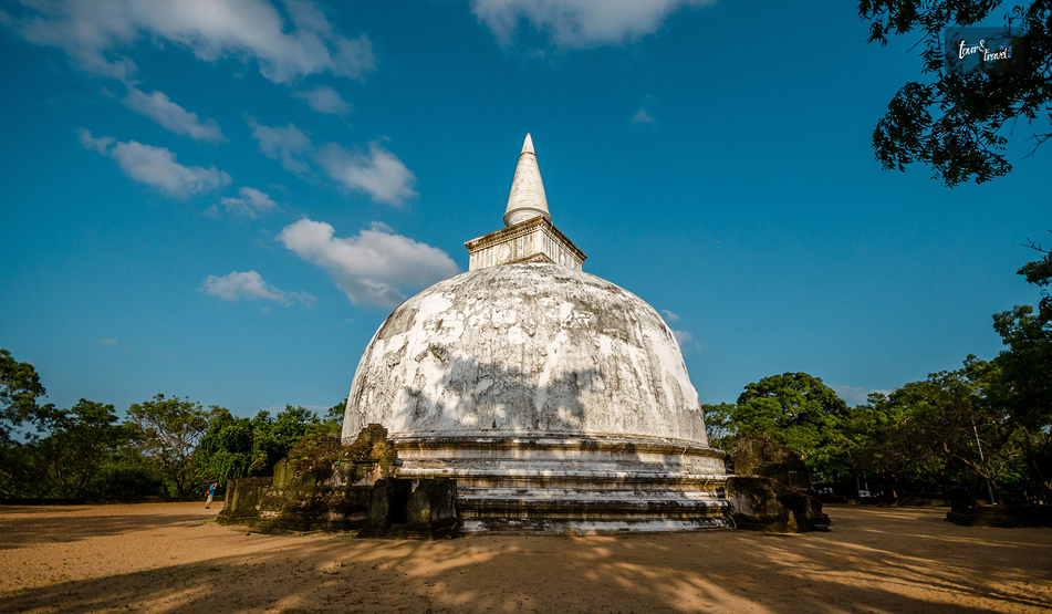
I got a glimpse of the Kiri Vehera through a gap in the trees. 

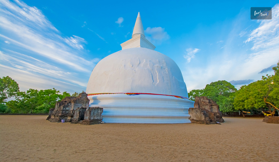
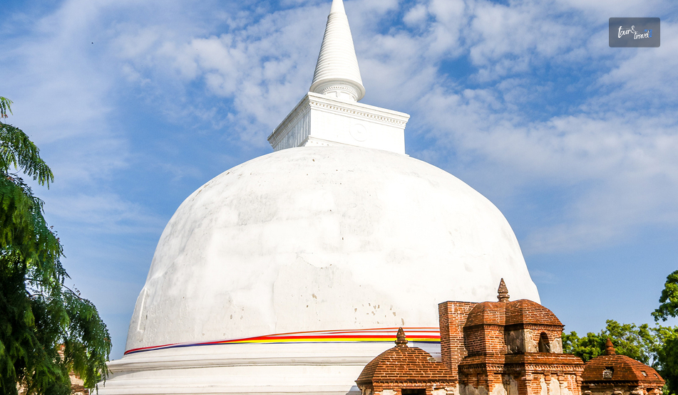
It was milky white, and even early in the morning, it looked the brightest among the surrounding ruins. 

Also, it is fascinating that the stupa is one of the few in Sri Lanka to have its original structure even after around 900 years. 

Locals say that when the stupa was discovered amidst the jungle, its chunam, or lime coating,g was still intact. 

Thus, it got its name as Kiri Vehera, or Milk White Stupa. 

Furthermore, along with being the best-preserved stupa, it is also a classic example of Bubulakara, or the bubble-shaped form of stupa. 

Kiri Vehera At A Glance

DetailFact
Meaning“Milk Stupa”It was originally called Rupavati Chetiya.
BuilderQueen Subhadda, consort of Parakramabahu I (1153–1186)She was also known as Bhaddavati.
TypeBubbulakara (bubble-shaped) stupa on three receding terraces
HeightAround 24 meters for the damaged stupa. 
Base diameterAbout 26.8 meters
TerraceAbout 57.6 meters
RankSecond-largest stupa at Polonnaruwa
StatusStill an active place of worship
Entry FeeIncluded in the $25 Polonnaruwa ticket. 
Hours7 AM to 5:30 PM

My Walk Around The Milk Stupa

Kiri Vehera, Polonnaruwa: Walking Around Sri Lanka’s Best-Preserved Milk Stupa

Kiri Vehera is just north of Lankathilaka.

I just took a short walk over after the image house to reach this stupa. 

First Impressions Of The White Dome

As I have mentioned, the white plaster of the dome glowed against the blue sky. 

It has the simplest design with very little ornamentation. 

Polonnaruwa’s builders kept this design deliberately simple. Small subsidiary stupas dot the platform, and the scale felt human rather than overwhelming.

The Devatā Carvings Most People Miss

Don’t miss a close look at devatā-koṭuva. 

It has the most unusual carvings of deities, and these are uncommon for a stupa. 

This drum-like structure has carvings of eight divine figures in a folded-hand posture. It looks like they are worshipping Lord Buddha. 

Circling The Stupa With Respect

I saw devotees visiting the stupa and offering flowers.

They lit oil lamps and walked around the stupa as part of their prayer rituals.

Also, you have to keep your shoes outside the brick fence. 

History And Architecture

Kiri Vehera, Polonnaruwa: Walking Around Sri Lanka’s Best-Preserved Milk Stupa

The stupa dates to the reign of Parakramabahu I.

Furthermore, it is part of the king’s vision to build a large monastic university, Alahana Pirivena. 

Also, the building programme of the king helped reshape Polonnaruwa.

Queen Bhaddavati And The Rupavati Chetiya

The Mahavamsa credits the building of this stupa to Queen Bhaddavati. 

As a woman, I appreciated the fact that the best-preserved monument in the ancient city is a queen’s commission, not a king’s.

The Terraces And Dimensions 

The architectural design of the monument features a stupa positioned directly in the center of an expansive square terrace, with each side stretching roughly 57.6 meters (189 feet). 

The main dome spans a diameter of 26.8 meters (88 feet) at its base. 

From the ground up to its fractured spire, the entire monument reaches an approximate height of 24 meters (80 feet).

Supporting the core structure are three stepped basal terraces, traditionally called pesavas. 

Standing between 0.9 and 1.2 meters (3 to 4 feet) high, these tiers likely functioned as pathways for devotional walking rituals (circumambulation) or as ledges for leaving flowers. 

This design element directly mirrors ancient Indian architecture seen at historic sites like Sanchi.

Sitting atop the dome is the hatareskotuva (a square tee) built from solid brick, measuring about 7.4 meters (24 feet 4 inches) wide and 3.7 meters (12 feet) tall. 

Resting directly above this square section is the devata-kotuva (the enclosure of the deities), a rounded drum that is 2.9 meters (9 feet 6 inches) wide and 2.3 meters (7 feet 8 inches) high. 

This circular tier is decorated with carvings of eight gods shown praying with their hands joined in deep respect. 

The final crowning element is the kota (spire), which extends upward for another 7 meters (23 feet), though fragments of the spire have eroded away over the centuries.

The Relic Chambers And The Interior Of The Stupa

In the early 1900s, British archaeologist H. C. P. Bell conducted systematic excavations that offered a rare glimpse into the inner architecture of the stupa. 

During his investigation, Bell uncovered a winding, 25-foot (7.6-meter) tunnel carved out centuries earlier by grave robbers targeting the structure’s sacred treasures. 

After clearing out this passageway, his team discovered two upper relic chambers that had unfortunately already been broken into and stripped of their valuables.

The first looted chamber spanned roughly 11 feet 2 inches (3.4 meters) wide.

It originally housed structural foundations meant to secure a yantragala (a traditional stone reliquary).

It also had a sacred Mahameru stone, which serves as a symbolic representation of the cosmic mountain.

Crucially, a third, lower chamber escaped destruction. 

Because the historical looters had not dug deep enough, this final vault remained perfectly sealed and intact. 

Out of preservation and respect, Bell’s archaeological team made the deliberate decision to leave this third chamber unopened.

Why The Plaster Survived

When the jungle was cleared after roughly 700 years of neglect, the lime plaster was in near-perfect condition. 

Engineers describe these plasters as closer to lime-concrete than ordinary stucco. 

That waterproof skin explains why brick has not crumbled here as it has elsewhere.

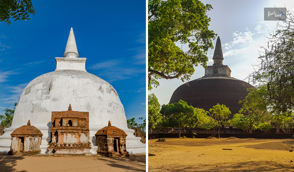
Kiri Vehera Vs Rankot Vehera: Two Ways To Read A Stupa

Kiri Vehera, Polonnaruwa: Walking Around Sri Lanka’s Best-Preserved Milk Stupa

I compared Polonnaruwa’s two great stupas on the same day.

Each of them has a different mood. Rankot is impressive because of its size, while Kiri Vehera impresses by its survival.

FeatureKiri VeheraRankot Vehera
BuilderQueen Bhaddavati (12th century)King Nissanka Malla (1187–1196)
HeightAbout 24 Meters54 Meters
SurfaceOriginal lime plaster largely intactExposed brick, like most stupas of its era.
Best forPreservation and quiet worshipSheer scale

How I Would Fit It Into A Day

Kiri Vehera, Polonnaruwa: Walking Around Sri Lanka’s Best-Preserved Milk Stupa

I spent about 45 minutes here, then moved on to Gal Vihara before the midday heat. 

Also, it is a short walk from Lankathilaka and offers the strongest contrast in appearance.

The image house is a ruin, and the Buddha statue there is headless. However, this stupa has had the same structure since the time of its foundation. 

Photography Tips

With its human scale, Kiri Vehera is a favorite of photo enthusiasts. 

However, if you are visiting the stupa mid-day, the mid-day glare will bounce off the white plaster. 

On the other hand, morning and late afternoon, with softer light, are better times of the day for photography. 

Also, never take selfies posing back to the stupa, as it is disrespectful, and the guides will stop you if you even try to do that. 

Why Kiri Vehera Matters Today

The ruins of the Anuradhapura Sacred City and other remains of Polonnaruwa raise a question.

What did these monuments look like when they were finished? 

Kiri Vehera is the only monument to offer an answer to this. 

Also, as a living worship shrine, it is a site that allows you to slow down. 

So, if you are rushing past it on the way to Gal Vihara, you will miss the quiet centre of the northern complex.

Share on Social Media

Sibashree is a travel, culture, and leisure writer who has been writing since the age of 12 and professionally since 2014. With more than a decade of travel writing experience and journeys across India and several parts of the world, she brings a deeply personal and thoughtful perspective to her work. A student of English Literature and Mass Communication, Sibashree has always viewed travel as more than movement — for her, it has been a way of understanding people, cultures, and herself. Her passion for spiritual exploration has also led her to many unusual and meaningful destinations over the years. Outside of writing, Sibashree enjoys watching European cinema, reading about global politics, and reflecting on the stories hidden within everyday places.

Leave a Reply

Your email address will not be published. Required fields are marked *

title-img Related

READ MORE Everest Trekking

Top Reasons To Do Everest Trekking: Himalaya View Treks

BY  Sibashree May 4, 2024

The Everest Base Camp Trek is a gorgeous stroll that a trekker needs to cover. Indulging in this grandiose walk allows you to scrape out some of the nicest sights of your life. It isnot just the views of peaks including Mt. Everest, Ama Dablam, Pumori, and Lhotse. You will be also amazed by the images of the lush woods, clean rivers, glaciers, and quaint hamlets. The trekking on Everest base is the third most famous trekking vacation spot in the world. Apart from nature, this trek also gets you pretty close to the dwelling locations of the Sherpas.  It evokes everyone's emotions to a point where you will get to examine a lot of the deep meanings associated with life. Overall, the Everest Base Trek is well worth doing for many reasons. And here, we have woven together the 5 pleasant reasons that you will enjoy doing a trek at the Everest Base. Hillary Bridge (Nepal’s Highest Suspension Point): Hillary Bridge is the easiest suspension bridge in the Khumbu area and expands on top of the Dudh Kosi River. Keep the final bridge for the second or third day of the Everest Trek rather than opting for an abrupt ascent to the Namche Bazaar street.  The non-secular prayer flags flying all across the bridge offer you spiritual and religious vibes. However, the bridge gives you a distinctive vibe of freedom. NamcheBazaar (Mountain Bazaar) (Sherpa People and their Mountain Lifestyle): Namche Bazaar is widely regarded as the tourism capital and the biggest sherpa agreement in the Khumbu area. The city is actually stunning and offers various rejuvenating vacation spots near Everest. Tourism refers to the primary carrier for people residing in Namche Bazaar.  This city portrays a magnificent glimpse of mountain tops. These include Kongde Ri (6,187 m), Thamserku (6,623 m), and, additionally, the 8,848 m-high Everest. All across the town, you will find several restaurants, cafes, lodges, bakeries, Tibetan handicraft stores, and even museums.  NangkarTshang Hill Standpoint (Hiking Place From Dingboche): After Namche, Dingboche is the area where we take a relaxation and adaptation break. During the day, you can go to NangkarTshang Hill’s viewpoint. A 3-hour hike starts from the Dingboche village, extending to the summit of NangkarTshang Hill. It presents views of Makalu, Lhotse, Mera Peak(Island Peak), and Choopulu. Unparalleled Scenery: If you want to head over to excellent scenery, this is where you should go. Along with Himalayan wasteland thrills, you will get to see dozens of mountains.  A lot of peaks can trip their base camps, too. Furthermore, the way offers picturesque destinations that allow you to take Instagram pictures.  Starting from the first day, trekkers are capable of witnessing colossal snowy peaks. Further, it is, in all likelihood, the sole trekking path where you get the mountain surroundings all through the trip.  Lhotse, Everest, Choyou, and Makalu peaks offer grandeur in the entire area. These peaks are in the top 10 absolute best mountains in the world. Hometown Of Sherpa And Unique Culture: This is the first reason the Everest base camp journey has become more popular. Everest Touring Trails are trails that are completely grounded in Tibetan Sherpa culture. Everest Camp Touring Camp Touring trails is only one touring stint in Nepal, where you'll enjoy the Tibetan Buddhism religion and culture. All the touring routes of the Everest region offer pedestrians the unique culture of the Tibetans, the Tibetan Sherpa culture of Nepal.  Tengboche Friary: Tengboche Friary is another third magnet on the Everest hiking trip. It is located in a 3890-meter-high place. There, you will enjoy a Tibetan Sherpa religious experience and a fantastic panoramic view of the whole Everest region of the Himalayas.  The fabulous Sherpa culture of Everest is a subject of important admiration and alleviation for most people around the world. Similarly, the Base Camp Trek at Everest presents a perfect occasion to enjoy the fabulous culture and tradition of the Sherpa. As a matter of fact, the Sherpa people are known worldwide for their nearly superhuman mountaineering chops. Nearest Views Of Mt. Everest From Kala Pattar: The view of Mt. Everest from Kala Patthar is a rallying point of the Himalayas, especially Mount Everest. Kala Pattar is only one stylish and closed viewpoint of Mt. Everest, which is really beyond the imagination and has superb views. The Himalayan lookouts of Nepal are the country’s biggest draw points. The Everest Camp Trek also doesn't fail in this aspect; therefore, you should definitely consider visiting it once in your lifetime. Religious And Cultural Prolificacy: A lot of Sherpa agreements on the EBC route provide Mani buses, prayer flags, inscribed Mani boulders, Gompas, and Chortens. The inhabitants of this region are known to have migrated somewhere from Tibet 400 years ago. Moreover, they still revive the conventional Tibetan language as well as culture. People belonging to this region are not only simple, gracious, and generous but also strict followers of Buddhism.  The Pangboche and Tengboche Gompas are two of the most primitive gompas, each with its own history and significance. The former bone belongs to the biggest gompa of the Khumbu region. It is encompassed by Nuptse, Tawache, Lhotse, Thamserku, and Ama Dablam. These are joints for the Festival, Mani Rimdu. The festival is the longest and takes place from October to November. The concept goes after the bone, which was said to have the genuine Yeti’s crown and hand. However, it just has a replica only. Furthermore, the Tengboche Gompa( friary), Pangboche Gompa, and multitudinous cloisters represent the artistic and architectural productivity of this region. The Sagarmatha National Park: This magnificent demesne, which was added to the UNESCO World Heritage List in 1979, is a biodiversity mecca. Rich in foliage and fauna, Sagarmatha National Park is home to rare species of creatures like snow leopards and black-and-white pandas. It also has hares, jackals, wolves, and numerous others. It is further home to around 200 species of catcalls, some rare, some common. However, all call the thick timbers of this demesne home. The demesne has numerous touring trails within it. It also introduces you to the unique culture of the mountain communities. These communities live within its borders in complete harmony with their surroundings. Everest Base Camp (The Ultimate Peak): Let’s admit it! We have been waiting for this site for so long. 5300m is the elevation of Everest Base Camp, which is the closest to hiking. However, being closer to Mt. Everest, this camping point is prone to natural disasters. Once you are done hiking at the base camp, you will see a magical kingdom full of pebbles, rocks, and snow. This gives trekkers a sigh of relief and success.  The entire Everest Camp location is full of colorful prayer flags, a never-ending valley, and skyscraper-high snow peaks. Also, how can we forget the stunning Khumbu Glacier Icefall, which is a popular touchdown spot for all camp helicopter tours? Begin The Journey To Mount Everest Beginning the epic journey to Mt. Everest is a once-in-a-lifetime memory and experience. So, every step leaves an indelible mark on the hearts of those who dare to complete this extraordinary path. From the vistas of snow-capped peaks and cultural diversity in Sherpa Village to the accomplishment of reaching Everest Camp!  Apart from these reasons, there are several other factors that would compel you to do the trek. Other reasons that might captivate you are suspension bridges, waterfalls, moraines, glacial rivers, and glaciers. Learn More Also: Trekking Kilimanjaro & Salkantay Top 5 Unexplored Treks In Himachal Life Is Enjoyable: Incorporate 7 Best Unique Treks In The World

READ MORE Mannar

Mannar, Sri Lanka: The Island I Almost Skipped

BY  Sibashree Jul 10, 2026

Many unexpected things happened during my trip to Sri Lanka. For example, I did not expect what I felt at the Dambulla Royal Cave Temple.  Similarly, there are places like Puttalam. Puttalam stands out with its ancient history, wildlife, coconut plantation, and ideal ambiance for stargazing.  However, of course, Puttalam is not as celebrated as the cultural richness of Kandy or the thrill of a Kandy to Ella train ride. It is more like a hidden gem.  Now, talking about hidden gems, Mannar is another destination I almost missed.  I am glad that I did not ultimately! In recent times, it has become the land where women are fighting for the protection of their bodies and land impacted by industrialization, bypassing their consent.  In this article, I will share my experience in Mannar, and of course, why women in this coastal village are putting up such a strong fight.  However, I will begin with why I almost missed it. This Is Why I Almost Missed Mannar Mannar is not a usual or bucket-list destination when planning a trip to Sri Lanka. So, it was not originally on my list even after multiple visits to the country.  For the first time, Jaffna and its Tamil culture were my priority.  Also, for the next time, it was quite a predictable loop with Ella for the hills, Kandy for the temples, and Mirissa for the beaches.  Again, while Mannar kept popping up as a suggestion, most forums described it as "connected by a causeway, has some baobab trees, not much else."  So, I never had Mannar on my mind.  However, when I visited Sri Lanka for the third time, my focus was more on historical exploration in the country. It is because the history of the country here is so connected to the country I come from, India.  So, I was staying in Anuradhapura, and Adeesha, the guesthouse owner, told me about Mannar.  He said, “Mannar is where Sri Lanka forgets it's an island for a while. The wind never stops, and neither do the birds." This description stayed with me. And in three days, I took to the Medawachchiya-Talaimannar Highway for a road trip to Mannar.  The distance was around 119 km, and it took around 2 hours and 17 minutes.  Initially, I thought that it was a mistake as I saw the landscape flattening out into salt pans and scrub.  However, I had not!  Mannar Reminded Me Of Art Of Slow Travel: We All Know It But Often Forget  I planned a half-day detour and ended up staying two nights, and even that felt like less.  What I appreciated most was how little the island tried to perform for visitors. You don’t have a polished tour script to follow. Also, from the causeway moment to standing on the spot where two countries meet, you will not notice the crowd for photo ops.  And do you know what you have as your companions here?  Just baobabs older than most nations, donkeys that own the road, flamingos that don't care if you're watching! Also, it has a stretch of water that people once believed connected two entire countries! So, Mannar is more than worth being beyond an afterthought when you are planning a trip to Sri Lanka.  I certainly did not expect a forgotten causeway town to end up as one of my favorite stops in the entire country, but that's exactly what happened. Here are more details about my days in Mannar, from the causeway moment to visiting the historical fort.  1. The Causeway Moment There's a specific moment on the drive-in that I still think about.  I left the palm-fringed road of the mainland behind, and the land narrowed into a causeway with water pressing in on both sides.  I rolled the window down, and I instantly felt the gush of wind on my face.  My driver, Aslam, laughed and said I should get used to it.  Talaimannar, further west, is considered one of the windiest points in the country, which is exactly why it's become a magnet for kite-surfers. Crossing that causeway felt like flipping a switch. The dense, wet green of the rest of the island gave way to something drier, flatter, and quieter.  I hadn't expected Sri Lanka to have a landscape like this, and it was closer in spirit to the Deccan scrublands than to a tropical postcard. 2. First Impressions Of Mannar Town Mannar town itself is unhurried in a way that took me a day to appreciate.  My first afternoon, I wandered past fishing boats pulled up on the shore, nets drying in loose piles. I also spotted a handful of tea shops. Conversations paused there just long enough for someone to glance at the obvious outsider before returning to their card game.  Nobody tried to sell me anything. It was the first place in Sri Lanka where I felt like a guest rather than a customer. 3. Meeting The Giant Of Pallimunai I was not prepared for the first baobab tree I spotted in Mannar. Seeing it for real is a different experience than seeing the photos.  The barrel-shaped trunk was wider than a small room, and the branches moved upward.  Furthermore, it had a thick and wrinkled grey bark, which gave it the name of the “Elephant Tree” from the locals.  However, the most famous one among the baobab trees in Mannar is the one in the village of Pallimunai.  It has a history of 600 to 800 years.  Furthermore, it was fascinating to think that baobabs are native to Africa and Madagascar, not South Asia. Common sayings are that the Arab traders carried the seeds here centuries ago. They were possibly using the leaves as camel fodder during the long sea crossings. The seeds eventually took root in Mannar's dry soil. I sat under that tree for a good twenty minutes. A local teenager on a bicycle stopped to chat, half in English and half in gestures.  He told me his grandfather used to tell him the tree was older than any building on the island. Looking up at it, I believed him completely. Things To Know About The Baobab Trees In Mannar Mannar has around thirty baobab trees scattered across the district.  Not all of them are as gigantic as you expect them to be. However, even the smaller ones along back roads and behind houses will grab your attention with their unique silhouette.  4. The Donkeys Of Mannar The feral donkeys are a part of Mannar’s wildlife identity.  They come from the animals the Arab merchant brought generations ago.  When I reached Mannar, I spotted them wandering freely across the island. They were unbothered by traffic or tourists. Even I watched one calmly block an entire lane of road near the causeway. They were chewing grass with the unhurried confidence of something that knows it has the right of way. Aslam just waited it out, grinning. "This is Mannar traffic," he said. 5. Flamingos At Vankalai My visit to the Vankalai Sanctuary and the nearby wetland was one of the highlights of my trip to Mannar.  I spotted flamingos, and they looked unreal for the first few minutes. I have never been so up close to these majestic birds.  Furthermore, I spotted a flock lift off a shallow lagoon at dusk, and it was dusk. So, they were catching the last orange light for the day.  Everything around me paused for a while.  6. Adam's Bridge And Talaimannar: Standing Where Two Countries Almost Touch The furthest point of my trip was Talaimannar.  It was right at the western tip of the island. There, a chain of limestone shoals, the Adam's Bridge, stretches out toward Rameswaram in India.  In Hindu tradition, this is the causeway said to have been built by Rama's army in the Ramayana. Furthermore, geologically, it is a natural formation due to sedimentation and shifting sea levels over thousands of years. The Moment… I was standing on the shoreline, and the wind hammered at my jacket.  I squinted toward the horizon and tried to make out India. Certainly, I could not.  Now, being from the land of spirituality, the myth was quite fascinating. However, the practical history seemed more tantalizing.  It was one of the busiest pearl-trading points in ancient times, and it was famous even in Rome.  7. The Fort That Changed Hands Three Times On the way back, I stopped at Mannar Fort, a low, weathered structure sitting near the causeway.  The Portuguese built it in 1560, and then the Dutch took over until they surrendered to the British. Compared to the grandeur of the Galle Fort or the Sigiriya Rock Fortress, it is a small, crumbling monument to how many empires passed through this one unassuming stretch of coastline.  There wasn't a ticket booth or a gift shop. The caretaker nodded me through, and I wandered the ramparts alone, looking out over the water as the light started to fade. My Two Days In Mannar: The Itinerary  Here is my two-day slow travel itinerary in Mannar. Day 1: Causeway, Town, And Giants Time ActivityMorningThe Road Trip to MannarLate MorningThe Causeway MomentEarly AfternoonCheck-in and Town ExplorationLate AfternoonThe Giant of PallimunaiEveningMannar "Traffic" and Dinner Day 2: Ancient Connections, Wildlife, And Heritage TimeActivityMorningJourney to TalaimannarMid-DayAdam's Bridge ExperienceAfternoonVisiting the Fort of Three EmpiresDuskSpotting Flamingos at Vankalai Sanctuary That’s it from my days in Mannar. However, I want to conclude with a brief discussion on how women in Mannar are fighting for their bodies and soil.  Konniyan Kudiyirippu: A Mannar Village Where Women Fight For Their Bodies And Soil  Konniyan Kudiyirippu is a small coastal village on the southern edge of Mannar. Here, the lives of the women revolve around the soil and palmyrah. However, the setting up of a windmill here without consent has ruined their lives by poisoning the water and flooding the land.  That is not all! A mining company is eyeing this village.  I was reading about this news on eathjournalism.net, and there, a 32-year-old woman and a kindergarten teacher from the village, Vashingtina, mentioned,  “We use everything from nature to earn an income.” So, due to industrialization without consent, the village economy based on nature is about to be ruined.  The women of this village are putting up a fight against this and the violation of “the right to free, prior and informed consent.” So, come and visit Mannar to see how the women here are fighting one of the biggest battles of mankind, saving the environment vs. industrialization.

READ MORE Gal Oya National Park

Gal Oya National Park, Sri Lanka: A Place Where I Saw Elephants From Boats

BY  Sibashree Sep 7, 2026

I visited the Gal Oya National Park in 2022, and after a few months of being back in my country, I got a call from my friend in Sri Lanka.  It was December, and he shared the news published on the Daily Mirror Online, which mentioned the threats of illegal mining to the flora and fauna of the national park.  I felt numb, as this was not the Gal Oya National Park I visited. Even if Sri Lanka has icons such as the Yala National Park, for me Gal Oya offered the most remarkable encounters with elephants.  For the first time, I did a safari from a boat, drifting quietly across open water while a herd of elephants waded between islands ahead of us. There was no engine noise to spook them, no queue of vehicles, just the reservoir, the herd, and the sound of water. It felt more like a secret that Sri Lanka preserves so dearly, not a national park.  Gal Oya National Park At A Glance DetailInformationLocationAmpara District, Eastern Province, Sri LankaEstablished1954AreaApproximately 25,900 HectaresCentrepieceSenanayake Samudraya, the Largest Reservoir in Sri LankaKnown forBoat Safaris and Elephants Swimming between IslandsWildlife32 Recorded Mammal Species, including Elephants, Leopards, and Sloth Bears150+ Bird SpeciesBest time to visitDry Season, Roughly May to SeptemberDistance from ColomboAround 300 KM,  Roughly 6 Hours by Road A Reservoir-Built Park With A History Tied To Irrigation The history of the Gal Oya National Park goes back to 1954. It was built to protect the Senanayake Samudraya. This newly constructed reservoir, the largest in Sri Lanka, was part of a major post-independence irrigation scheme in the dry zone of Sri Lanka.  The scale of the reservoir made my boat ride in the park all the more fascinating. It is just open water with forests around.  So, the jeeps on the dusty tracks are replaced by the boats on the serene water.  The landscape around the reservoir was more varied than I expected from a dry-zone park. Forested Hills! Savannah Grassland! Also, there were rocky outcrops that locals call turtleback formations.  Moreover, low grasslands all sit within the park's boundaries, alongside historical sites like the Digha Vapi Dagoba and the Henebedde cave. Wildlife And The Swimming Elephants The most fascinating experience in Gal Oya was watching wild elephants swimming between the reservoir’s islands.  They were moving in search of fresh grazing as water levels dropped in the dry season.  Beyond elephants, the park has around 32 mammal species, including: Leopards Sloth Bears Grey Langurs Endemic Toque Macaque. Also, the park, though not as fascinating as Bundala, has more than 150 species of birds. I could spot the following ones. Painted Storks Ospreys Endemics like the red-faced Malkoha and Sri Lanka spurfowl. I could also spot crocodiles and water monitors along the reservoir's edges. How To Reach Gal Oya National Park? You can take a drive from Colombo to reach Gal Oya National Park via Ampara. The distance is around 300 km, and the journey takes around 6 hours by road.  However, staying in Ampara Town as the base or finding a lodge close to the park’s boat safari jetty is a more reasonable move.  Also, Gal Oya National Park is a natural inland detour from the east-coast surf town, Arugam Bay, roughly 2 to 2.5 hours away. Again, if you are traveling from Kandy, it is 4-5 hours by road via Mahiyangana. So, Gal Oya is a workable stop on a route heading toward the east coast. Gal Oya Entrance And Boat Safari Costs (2026) On top of the park entrance fee, the boat safari itself is typically arranged and priced separately, usually through your lodge or a licensed operator. Remember that access to the reservoir's boats isn't managed the same way jeep permits are at other parks. Also, the boat safari costs around LKR 6000 to LKR 8000.  CategoryApproximate Cost (2026)Foreign Adult (12+)USD 12Foreign Child (6–12 Years)USD 6Foreign Children under 6 Years FreeSAARC NationalsUSD 10 for AdultsUSD 5 for Children between 6 and 12 YearsFree for Children below 6 YearsLocals Adults: LKR 60Children from 6 to 12 Years: LKR 30Children below 6 Years: FreeStudents: LKR 20Boat SafariLKR 6000-8000 A One-Day Gal Oya Itinerary A day at Gal Oya has a different rhythm from most Sri Lankan national parks because here the safari is on a boat and not a jeep.  Here is a structure that works well if you're based near Ampara or the park's eastern lodges. TimeActivity5:30 - 6:30 AMEarly transfer to the boat jetty on Senanayake Samudraya6:30 - 9:30 AMMorning boat safari.It is the best window for elephant sightings near the shoreline. 9:30 - 10:30 AMReturn to lodge for breakfast.10:30 AM - 12:30 PMOptional short trek or visit to the Henebedde cave/Digha Vapi Dagoba area.12:30 - 2:30 PMLunch and rest during the hottest part of the day.4:00 - 6:30 PMEvening boat safari for a second wildlife window and sunset over the reservoir. What Are The Practical Tips For Visiting The Gal Oya National Park?  Boats and slots are more limited than jeep availability at bigger parks. Bring a hat, sunscreen, and a light waterproof layer. Pack a zoom lens or good binoculars as elephant sightings are often across open water rather than at close range on a jeep track. Stay two nights if you can, so you get both a morning and an evening boat safari rather than just one. Combine with Arugam Bay or Ampara for a fuller east-coast itinerary. What Is The Best Time To Visit Gal Oya National Park? May to September, or the dry season, is the best time to visit Gal Oya National Park.  In the dry season, the water level of the reservoir drops. So, all the animals, especially the elephants, concentrate near the remaining islands and water.  Thus, the sight of swimming elephants is more common in this national park than anywhere else in Sri Lanka.  This season is also ideal for birdwatching in Sri Lanka, as migratory and resident species settle around the shrinking waterline.