Indiana state is famous globally as the “Covered Bridge Capital” because there are 32 covered bridges alone in Historic Parke County, which are discoverable through a road trip. Apart from the Indiana national parks, the state is also famous by the name of “great lakes state” since it shares 40 miles of shoreline with Lake Michigan.
The four national parks in Indiana are renowned as outdoor adventure destinations, namely the Indiana Dunes National Park, President Lincoln’s Boyhood Cabin, George Roger Clark, and the Lewis and Clark Historic Trail. Of the four national parks, Indiana Dunes National Park is a must-see destination.
Indiana Dunes National Park and George Rogers Clark National Historical Park are national parks in the term’s true meaning. And, the other two national parks in Indiana, i.e., Lincoln’s Boyhood National Memorial and Lewis and Clark National Historic Trail, are the two memorial sites in Indiana, recognized for their routes of historical significance or original trails by the National Historic Trails.
Let’s check more details about each of the national parks in Indiana and see how we can spend our day if we plan a trip there.
The Four Noted Indiana National Parks
1. Indiana Dunes National Park:
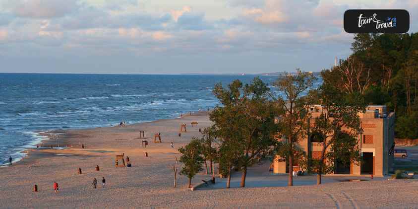
Of the four celebrated Indiana national parks, this one is an unmissable destination if you are in the state. The national park shares 15 miles with the southern shore of Lake Michigan. Indiana Dunes National Park is spread over 15,000 acres and has a lot to offer.
Your search for rare species of birds will end here, along with 1,100 native plant species and the fun of flying kites on the sandy beach. You will feel enchanted with every step you take in this national park as this place is among the most biologically rich areas in the nation.
The park offers 50 miles of trails over rugged dunes, sunny prairies, mysterious wetlands, peaceful forests, and meandering rivers for hikers. Shall we now check out basic information about the national park to plan our tour accordingly?
Directions To The Park: You can access Indiana Dunes National Park through Interstate 94, the Indiana Toll Road, U.S. Highway 12 & 20, Indiana State Road 49, and several other local roads. To visit the Indiana Dunes Visitor Center, you need to take Indiana State Road 49, between U.SD. Highway 20 and Interstate 94.
Operating Hours Of The National Park: This Indiana national park has general areas that are open throughout the year but have specific hours of operation. The standard working hours of the general areas of the national park are Monday to Sunday from 06:00 am to 11:00 pm.
The entrance to the Indiana Dunes National Park is through the west beach. The hours of operation of this portion of the park is Monday to Saturday from 07:00 am to 09:00 pm.
Weather News: Usually, July is the warmest month in the national park, and January is the coldest month. June month witnesses the heaviest rainfall with 4.66 inches of rain on average.
Entrance Fees To The Park:
West Beach – Standard Entrance Fee $6.00, Senior Pass Entrance Fee $3.00, Access Pass Entrance Fee $3.00, Bus Entrance Fee $30.00.
Dunewood Campground – Standard Camping Fee $25.00, Senior Pass Camping Fee $12.50, Access Pass Camping Fee $12.50. This campground is 1.5 miles from the beach and boasts 67 campsites made for both RVs and tent camping.
One-half of the site is open for reserve, and the other half is given on a first-come-first-served basis. You will find showers and restrooms at the campground but no water or electric hookups.
Indiana Dunes Visitors Centers:
Dorothy Buell Visitor Center – This Indiana national park visitor center is open on all days except New Year’s Day, Thanksgiving Day, and Christmas Day. The operation hours are 09:00 am to 04:00 pm Central Time (Due to covid-19). At Dorothy Buell, you will view lobby displays, read brochures about Porter County, Dunes State Park, Indiana, and Indiana Dunes National Park. You can also shop in the Eastern National Bookstore and enjoy watching educational displays and two short orientation videos.
Paul H. Douglas Center For Environmental Education – This visitor center is open from 09:00 am to 05:00 pm Central Time during Summers and from 09:00 am to 04:00 pm during Winters. This center is your gateway to the magnificent Paul H. Douglas Trail via Miller Woods. You will find a natural environment all through the center through its hands-on educational exhibits, animals, lectures, Nature Play Zone, ranger-guided hikes, and crafts.
Popular Activities To Do At The National Park:
Hiking.
Picnic at the beach.
Birding.
Swimming.
Fishing and Paddling.
Geocaching.
Horse Riding on the equestrian trails.
Camping (Between April 1st to October 31st).
Biking.
Snowshoeing and cross country skiing.
Shuttle Bus Services: During the summer period, on weekends, you can take the services of free shuttle buses from the Dunewood Campground to the beaches. You can stop at sites like the Miller Train Station, Marquette Park, Lake Street Beach, and The Douglas Center.
Pet Friendliness: Indiana Dunes National Park is completely dog-friendly. You can take your pet to almost all trails and other parts of the park, besides a few exceptions. For example, you cannot take your pets on Glenwood Dunes Trail’s equestrian part, in the lifeguard area of the West Beach, and the Pinhook Bog Trail.
You can enjoy a free public wi-fi facility at the Indiana Dunes Visitor Center.
2. George Rogers Clark National Historical Park:
Located on Southwest Indiana and beside the Wabash River, George Rogers Clark National Historical Park is one of the small Indiana national parks, which has a few monuments, a picnic spot, statutes, and a visitor center as its main center of attraction. The national park is about an hour tour in total.
Why Was George Rogers Clark National Historical Park Built?
George Rogers Clark National Park was built in the 1920s in memory of an American Colonel named George Rogers Clark, who captured Fort Sackville in 1779 and his army with help from French residents of the Illinois country. The capture of the fort guaranteed the United States a claim to the frontier, which is approximately an area as big as the original 13 states.
The National Park is a memorial built to commemorate Clark’s success for his unmatchable success for the revolutionary war’s 150th anniversary. When you visit this national park’s visitor center, you will discover the fort’s history, how it was built, and how it felt living in the Pullman District. In addition, at the national park, you will be shown a 30-minute short film on the life of George Rogers Clark.
Things To Do At The George Rogers Clark National Park
A short walk around the nearby town of Vincennes will offer you the following things to do at this small Indiana national park:
Dine at restaurants.
Camping at Campgrounds.
The Old Cathedral.
State Historic Sites.
Shops to shop.
Antique Stores.
There are particularly no campgrounds at George Rogers Clark National Park. But, visitors can find campgrounds for RV and tent camping at the Ouabache Trails Park, located in Vincennes.
Space For Pets: Your leashed pets can accompany you on the walkways around the Memorial and the visitor center, but their entry inside any buildings is strictly prohibited.
Operating Hours: The park is open for visitors on all seven days of the week. At the same time, it is closed on most of the federal holidays except Independence Day, Labor Day, and Memorial Day.
Timings for the Park District: George Rogers Clark Memorial is from 09:00 am to 04:45 pm on demand.
Weather At The Park: The weather inside the national park is very much typical for the Midwest. Summer months can be hot and humid, and winters quite cool.
Entrance Fees To The Park: For a George Rogers Clark National Park tour, there is no entrance fee charged.
The Visitors Centers To Visit: This Indiana national park has one visitor center with the same name as the national park. This center has a small exhibit area. You will be shown a short 30-minute introductory movie titled “Long Knives,” which tells about the backstory of George Rogers Clark and his military campaign. No drinks or food are allowed at the visitor center or Memorial. Services offered here are charging stations, restrooms, bookstores, and drinking fountains.
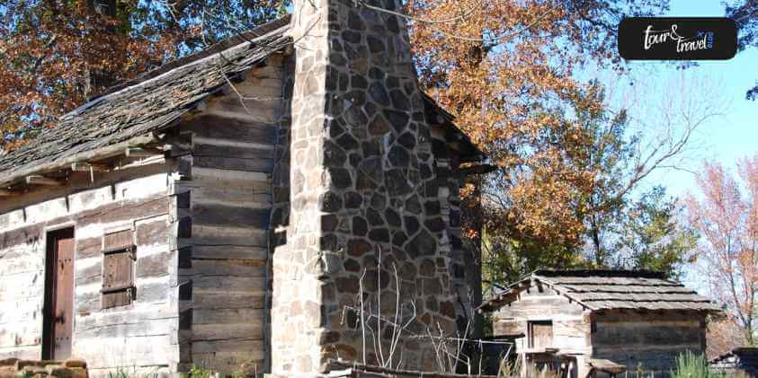
3. Lincoln Boyhood National Memorial:
In the southern part of Indiana and Lincoln City, you will find the third Indiana national park, named Lincoln Boyhood National Memorial. This is where former President Abraham Lincoln grew from youth to manhood before becoming the 16th President of the United States of America.
Operating Hours Of The Lincoln Boyhood National Park: All visitors are allowed to tour the national park grounds and visit all the outside areas daily, between sunrise and sunset. Once you arrive at the park, there are plenty of things that you can do, such as two miles of trails, watching the sculptured panels on the outside of the Lincoln Memorial Visitor Center, visiting the Cabin-Site Memorial, the Pioneer Cemetery, and the Living Historical Farm. Unfortunately, the park is closed on almost all federal holidays.
Weather At The Park: The climate in Southern Indiana is moderate, with a touch of warmness and moistness. The summers are warmer and winters cooler. It rains the most during Spring.
Visitor Center At The Park: The Lincoln Boyhood park has a Memorial Visitor Center built in 1943 with two memorial halls and a connecting cloister. In the Memorial Court, you will find the works of E.H. Daniels and five sculptured panels that mark significant periods in Abraham Lincoln’s life. Taking a tour of the whole Memorial will take up to 30 to 60 minutes.
There is also an orientation film shown at the visitor center every half an hour from 08:00 am to half an hour before the day’s closing. The Museum artifacts and exhibits speak about Abraham Lincoln’s life.
This national park is all about Lincoln’s family, boyhood, and frontier life in this Indiana national park area. During summers, the visitor center is open on all seven days from 09:00 am to 04:00 pm except for the federal holidays. And, at the time of the Fall season, the timings are 07:00 am to 03:00 pm.
Place For Pets At The Park: Visitors are permitted to bring in their pets inside the park, but with certain restrictions. The pets must be restrained at all times on a leash, which should not be longer than six feet in length.
The pets are only allowed on the 2 miles of hiking trails and roads in the park and barred from entering public buildings.
Things You Can Do At The Park: It will take at least two hours to complete a tour of the whole park. The indoor activities at the park include:
Watching the Park Film at the Memorial, titled Forging Greatness and Lincoln in Indiana, which is 14 minutes in length.
Paying a visit at the Lincoln in Indiana Museum, which would take around 15 to 30 minutes.
The outdoor activities include:
Hike the Trail of Twelve Stones, a type of front-country hiking of 20 minutes.
Hike the Boyhood Trail, which is another front-country hike of 10 to 15 minutes.
Visiting the Lincoln Living Historical Fa, you’ll find a re-created homestead with outbuildings, log cabins, field crops, gardens, livestock, and split rail fences.
For kids of 05 years and above, there is a Junior Lincoln Boyhood Ranger Program.
Lincoln Spring, which is an obscure waterway.
The entry to the Lincoln Boyhood Indiana national park is free.
4. Lewis And Clark National Historic Trail:
The Lewis and Clark National Historic Trail is nearly 4,900 miles long, starting from Pittsburgh, Pennsylvania, to the Columbia River mouth, which is near the present-day Astoria, Oregon. This Indiana national park follows the historic incoming and outgoing routes of the Lewis and Clark Expedition along with the preceding section initiating from Pittsburgh, Pennsylvania, to the Wood River in Illinois.
This Trail connects 16 U.S. States and many Tribal lands. Today, visitors are allowed to explore the whole Trail using varied transportation methods and interpretive means, following the approximate route of the Corps of Discovery, i.e. Lewis and Clark Expedition Members.
Places To Visit In Lewis And Clark National Park:
Lewis and Clark National Historic Trail Visitor Centers and Museums: At Lewis and Clark Historic Trail Museums and Visitor Centers and Cultural Centers, visitors can learn more about the expedition and experience blissful and diversified landscapes and communities on the Trail.
Directions To The National Park: You will find the Lewis and Clark Indiana national park visitor center inside the DOI, National Park Service.
Weather At The Park: The summers are sweltering, so you must drink plenty of water and wear sunscreen when stepping out for a tour of the Trail. The winters are icy, with ice settling on trails and sidewalks. Since this Trail covers 16 U.S. states, you must watch the weather prediction of the state you are planning to visit.
The Final Thoughts
We hope that the above comprehensive guide on Indiana national parks is a one-stop solution and a valuable guide for you if you plan a trip to any of the four national parks and trails. From serenity to beautiful natural landscapes, from magnificent and ancient monuments to rare species of animals, you will find every part of each of the four national parks surprising.
Mashum Mollah is the feature writer of Search Engine Magazine and an SEO Analyst at Real Wealth Business. Over the last 3 years, He has successfully developed and implemented online marketing, SEO, and conversion campaigns for 50+ businesses of all sizes. He is the co-founder of Social Media Magazine.
2 responses to “A Guide To Indiana National Parks – Latest Guide”
This was beautiful Admin. Thank you for your reflections.
Traveling to a new place can be a wonderful opportunity to experience different cultures and gain a deeper understanding of the world around us.
Did you know for example, that the cute little cherubs we associate with romance actually originated from Cherubim, who originated during ancient Mesopotamian times?
It can be fascinating learning these little nuggets of information!
Moreover, one of the best ways to do this is to fully immerse yourself in the ancient culture of a location on a holiday.
This can be a transformative experience, allowing you to connect with the history and traditions of a place in a way that simply visiting tourist attractions cannot.
Here Are Three Best Places You Can Immerse Yourself In Ancient Culture:
There happen to be a handful of locations that are perfect for immersing oneself in ancient culture, and we are going to take you through a couple of our favorites in this article.
Let’s dive right into it.
1. Egypt Is As Ancient As it Gets
A 10-day trip to Egypt offers travelers an unparalleled journey into the heart of ancient history and culture.
When experiencing the remnants of bygone eras, there is no better destination than this timeless land. Egypt, with its vast desert landscapes and the winding Nile River, boasts some of the most iconic ancient sites in the world, including the Great Pyramid of Giza and the Valley of the Kings.
Here, visitors can step into the shadows of great pharaohs, marvel at age-old engineering feats, and be captivated by tales that have shaped civilizations for millennia.
These sites are not only impressive in their own right, but they also offer a glimpse into the rich history and culture of ancient Egypt.
You can even wander around a plethora of ruins of temples and tombs and imagine what life was like for the people who built and used them.
If you want to go to one of the most historic locations on this earth, then you should plan a trip to Egypt right away. There is just no other place like it.
2. China Has A Rich Culture Of Ancient History
Next up, we have China. China has a long and rich history and houses a multitude of historical locations and landmarks, such as the Great Wall of China, the Temple of Heaven, and the Terracotta Army.
These sites can offer you an insight into the history and culture of ancient China, and you can learn about the customs, beliefs, and daily life of the people who built these impressive structures.
Visiting China can be a little expensive, so it is important that you learn how to fund travelling adventures before committing to a holiday in such a magical country.
3. Mexico Is An Underrated Gem
Another destination that is ideal for experiencing ancient culture is Mexico, specifically the ancient Mayan civilization. The Mayan civilization is one of the most fascinating and mysterious ancient cultures in the world.
Visitors to Mexico can explore the ruins of ancient Mayan cities, such as Chichen Itza and Tikal, and gain an understanding of the architecture, astronomy, and religious practices of this advanced civilization.
Additionally, you can also explore the Mayan culture by visiting the many cenotes or sinkholes, which the Mayans believed to be sacred places.
Mexico is an underrated gem when it comes to ancient culture, and you will be able to scratch your itch for ancient civilizations ten times over if you decide to give it a visit.
To sum up, immersing yourself in the ancient culture of a destination can be a truly enriching experience.
Whether you are exploring the ruins of Egypt, Mexico, or China, you will gain a deeper understanding of the history and culture of these ancient civilizations and come away with a greater appreciation for the world around us.
So, consider visiting one of these locations on your next holiday and try to fully immerse yourself in ancient culture for a truly memorable vacation. Have fun!
This outdoor oasis in the South is a solid wanderlust attraction. A scenic city that is always on the move can be your next perfect weekend getaway. The city is bustling with energy, and on a typical afternoon, you will see its locals as well as weekenders venturing into the Tennesse River along with their boards and boats. The bikers go up and down the hilly streets through the town, running and walking down the pedestrian bridge and playing with frisbees in the numerous parks. The parks look neat, being hedged by bike lanes and carefully placed benches. Public art makes the town come alive with color and socio-cultural significance.
The number of things that will stay with you long after you visit this town is too many, but one of them will be the food and the restaurants. There are also a lot of adventures to be had outdoors in this character-filled city. If you are looking for some weekend fun or a short trip to feel rejuvenated, this city is close by and has to offer a lot.
This is going to be the best weekend spot for you, and we have brought you the best of it. Here are some of the most fun and memorable things to do in Chattanooga.
Things To Do In Chattanooga
hotels.com
If you have thought about going away sometime and taking a break, but you can’t think of any place so far. Chattanooga could be a great option. Here are some of the best things things to do in Chattanooga that will stay imprinted on your memory.
Tennessee Aquarium
tnaqua.org
One of the fun things to do in Chattanooga is visiting the aquarium. This aquarium maintains two buildings. There is River Journey which showcases the freshwater habitats from around the world, and Ocean Journey, where visitors are treated to the magnificent view of sea creatures and ocean life. It is recommended to spend at least three hours while visiting to take in a good fraction of the 10,000 animals that are here. If you are looking for things to do in Chattanooga with kids, they will love the adorable macaroni penguins and dreamy sea jellies.
Try visiting on a weekday, as it gets busier on weekends, for a more authentic experience. If you are looking for free things to do in Chattanooga, the city also offers a free shuttle to get here, making the experience pocket-friendly.
Lookout Mountain
cntraveler.com
There are three scenic attractions this mountain ridge has to offer. There is the Ruby Falls, Rock City, and the Incline Railway. The Ruby Falls is the United States’ deepest and tallest underground waterfall standing at 260 feet. Rock City is where one can see seven states from the iconic Lover’s Leap. And when you hop on the Incline Railway, you will be witnessing the steepest passenger railway on Earth.
You need to spend a minimum of 4 hours at these mountains to gauge the highlights of the spot. Each of the three attractions has separate expenses, and the tickets are known to sell out fast.
Raccoon Mountain Caverns
wikimedia.org
The Raccoon Mountain Caverns are located 1.3 miles off the I-24 at the Lookout Valley exit. It is less than 10 minutes from downtown Chattanooga. This mountain offers views of a cave in its natural state that has thousands of diverse rock formations. There are stalagmites, stalactites, flowstone, delicate soda straws, rimstone pools, columns, draperies, natural bridges, and a rare shield formation.
It also offers many wild cave “spelunking” expeditions for all those who want to go deeper into the caves and explore the mountain. An expedition to the waterfall dome allows visitors to get to the place with the view of the tallest underground, unassisted, naturally flowing waterfall.
Walnut Street Bridge
pickyourtrail.com
This is one of the best examples of the Phoenix wrought-iron truss bridges dating back to the years between 1884 and 1923.
Tennessee Valley Railroad Museum
wp.com
This nostalgic train trip will offer aesthetically restored vintage locomotives and passenger cars that encase the intricate craftsmanship of ages long gone. The ride will take you through the beautiful Tennessee countryside that has awe-inspiring views bound to make you reflect on the simpler times of the past. The museum’s exhibit has an impressive set of artifacts, old photographs, and other memorabilia that help bring the rich railroading history to life.
The staff here are highly knowledgeable and will eagerly share information on railroad history while being dressed in period attire. The experience will provide you with lots of fascinating insights whether you are a history buff or otherwise.
Ruby Falls
simpleviewinc.com
This one is the deepest and tallest underground waterfall that is open for public access in the States. There are guided tours such as the classic waterfall tour, the lantern tour, and the extended cavern experience tour. The tour will take you along its beautiful cavern trail to a gorgeous waterfall that is surrounded by old geological formations that took millenniums to form. There are also extensively picturesque views of the Cumberland Plateau, Tennessee Valley, and the Tennessee River from the top of the Lookout Mountain Tower. The tours fill up pretty quickly. You must purchase the tickets online in advance for increased availability.
Chattanooga Whiskey Experimental Distillery
chattanoogawhiskey.com
One of the other things to do in Chattanooga for adults is visit the whiskey distillery. This distillery is the first ever to craft whiskey in Chattanooga in over a hundred years. It boasts over 100 different barrels that mature in an aging cellar. Each visit to the distillery is an ode to the past, present, and future of hand-made bourbon. You can reserve a tour & tasting trip to check out their latest craft. This can also be one of the things to do in Chattanooga for couples.
You must be 21+ with a physical and valid ID.
Creative Discovery Museum
This museum is a hands-on children’s museum at the very heart of downtown Chattanooga. It is known to inspire children of all ages to innovate, explore, play, and create. The exhibits are designed to entertain as well as educate children on exploring the world around them. They are pushed to become inquisitive about art, science, music, water exploration, and dinosaur digging.
It was rated number #7 by Trekaroo of the children’s museums in the U.S. in 2015.
Wrapping Up
Chattanooga sure has everything you could want for a short trip away from the hustle of the city. If you want to know about things to do in Chattanooga this weekend, we hope this article gave you a headstart.
If you have thoughts to share or questions to ask, please leave a comment below. We would love to hear from you!
Read Also:
You Won’t Believe The Best Things To Do When In Fiji!
Some Of The Best Things To Do In Navarre Beach, Florida
These Are The 30+ Things To Do In Mexico City That You Must Try!
Costa Rica is a tropical gem between the Pacific Ocean and the Caribbean Sea.
This is home to various picture-perfect beaches. Beaches in Costa Rica have over 800 miles of coastline. They are as diverse as the country's lush rainforests and vibrant wildlife.
This Central American paradise is perfect for families seeking unforgettable experiences. However, Costa Rica has 300 beaches. So, choosing a destination that caters to all age groups can be challenging.
Fortunately, Costa Rica's beaches offer many attractions and activities. You can choose gentle waves, thrilling water sports, or pristine sands. These handpicked best beaches in Costa Rica are perfect for family vacations. Each has its unique offerings, safety, and family-friendly atmosphere.
Are you ready to find the ultimate beach haven for your family? Dive into our guide and let us unveil the magic of Costa Rica's coastal treasures. Let’s get started!
Criteria for Family-Friendly Costa Rica Beaches
As mentioned earlier, there are tons of beaches in Costa Rica. And if you are just traveling for a short amount of time, it is impossible to go to all of them. Thus, it's essential to choose the right beach that meets the needs of every family member.
This is to ensure that you’ll have an unforgettable experience. The following criteria will help you select the best beaches in Costa Rica.
Safety and Cleanliness
Safety should always be a top priority when planning a family vacation. Look for beaches with calm waters and gentle slopes. This is ideal for children who want to splash around without worrying about strong currents.
Additionally, choose clean and maintained beaches. This will ensure a healthy environment for your family.
Accessibility and Facilities
Find a beach that’s accessible, with parking options and well-maintained paths. Additionally, consider beaches with essential facilities. These are restrooms, showers, changing areas, and nearby restaurants or snack bars. This will please everyone throughout the day.
Activities and Attractions
A family vacation is only complete with activities and attractions to entertain everyone. When selecting the best beaches in Costa Rica, consider those that offer water sports. Also, find beaches near attractions, like national parks or wildlife refuges.
Top 5 Family-Friendly Beaches in Costa Rica
Now that we’ve established the criteria for family-friendly beaches, let’s discover the top 5 beaches in Costa Rica. These beaches will offer a blend of natural beauty, safety, and activities for the family.
1. Playa Conchal
Playa Conchal is one of the most beautiful and pristine beaches in Costa Rica. It's unique white sand and turquoise waters make it perfect for family vacations.
The beach is on the northwestern coast of Costa Rica, in the province of Guanacaste. It's accessible by car, with paved roads leading to the beach.
The beach is famous for its crushed-shell sand. It gives a unique and stunning appearance. Also, its crystal-clear waters are ideal for swimming and snorkeling.
Activities and Attractions
Playa Conchal offers a variety of family-friendly activities.
Boat Tour: You can take a boat tour to explore the Catalina Islands. It is typical to spot various marine creatures. On a good day, you'll see manta rays, turtles, whitetip reef sharks, and much wildlife on the Island.
Snorkeling and Swimming: The beach has calm waters and rich marine life. This makes Playa Conchal an excellent spot for snorkeling. Kids will love spotting colorful fish and marine creatures.
Nearby Resorts and Restaurants: The beach is close to several all-inclusive resorts. They offer many amenities and activities. There are also various local restaurants nearby, serving delicious Costa Rican cuisine.
2. Manuel Antonio Beach
Manuel Antonio Beach is one of the best beaches in Costa Rica. It is on the Pacific coast within the renowned Manuel Antonio National Park. This beautiful beach is accessible by car or bus. This makes it a popular destination for Costa Rica vacations. The beach is also known for its white-sand shores and crystal-clear waters.
Manuel Antonio Beach offers a stunning backdrop for your family vacation. The surrounding rainforest is teeming with wildlife. You’ll see monkeys, sloths, and colorful birds on a good day.
Activities and Attractions
Manuel Antonio Beach is a picturesque location and offers many activities. Here you can swim, snorkel, or simply relax on the shore. There is something for everyone to enjoy.
Manuel Antonio National Park: This is a popular national park next to the beach. It is the perfect spot for family hikes and wildlife spotting. The park's well-maintained trails suit all ages. This makes it a must-visit destination during your Costa Rica vacation.
Guided Tours and Beach Activities: Plenty of guided tours and activities are available for families. This ranges from wildlife safaris and snorkeling to zip-lining and horseback riding.
Nearby Accommodations and Dining Options: Manuel Antonio boasts many accommodations. You can choose from luxury resorts to budget-friendly hotels. Many dining options have local and international cuisine. This will ensure a satisfying culinary experience during your stay.
3. Tamarindo Beach
Tamarindo Beach is on the Pacific coast in Guanacaste province. It is one of the most accessible and popular beaches in Costa Rica. Liberia International Airport is only an hour away from the beach.
Tamarindo has a long stretch of sandy beach and consistent waves. This makes it a favorite destination for beginner and experienced surfers. The wide beach also offers plenty of space for sunbathing and playing in the sand.
Activities and Attractions
Besides surfing, Tamarindo Beach offers a variety of activities. Examples are snorkeling, horseback riding, and canopy tours. Additionally, nearby national parks provide opportunities for wildlife watching and eco-tours.
Surf Lessons for All Ages: Many surf schools in Tamarindo offer lessons for all ages and skill levels. This makes it the perfect place for the entire family to learn and enjoy surfing together.
Wildlife Watching and Eco-Tours: For nature lovers, Tamarindo Beach has diverse ecosystems. It provides opportunities for wildlife watching and eco-tours. Families can explore the nearby Marino Las Baulas National Park. You can also enjoy a boat tour through the mangroves of the Tamarindo Wildlife Refuge, or even head out on one of these Tamarindo fishing charters.
Variety of Restaurants and Accommodations: Tamarindo offers a wide selection of restaurants and accommodations. Nearby restaurants offer Caribbean-inspired cuisine, local seafood, and international options.
4. Playa Hermosa
The beach is in Guanacaste Province. Playa Hermosa is one of the most accessible and best beaches in Costa Rica. It is only a 25-minute drive from Liberia International Airport. This tropical haven is perfect for families looking to maximize their beach time.
Playa Hermosa boasts calm waters and a relaxed atmosphere. This makes it the perfect spot for a family getaway. It has gentle waves and warm, crystal-clear waters. This makes it an ideal destination for swimming and lounging on the golden sands.
Activities and Attractions
This Costa Rica beach offers plenty of family-friendly activities and attractions. There's no shortage of things to do. You can go kayaking and paddleboarding or play beach volleyball. If you’re adventurous, consider a snorkeling tour to explore the vibrant marine life.
Beachfront Restaurants and Hotels: Families will appreciate the beachfront restaurants and hotels along Playa Hermosa's shoreline. Choose from various dining options that include local Costa Rican cuisine and fresh seafood. Many hotels also offer kid-friendly amenities. It ensures a comfortable and enjoyable stay for the whole family.
Nearby Adventure Parks and Wildlife Reserves: Families can venture to adventure parks and wildlife reserves for a break from the beach. Explore Rincon de la Vieja National Park. This is perfect for hiking, wildlife spotting, and volcanic hot springs. Also, Diamante Eco Adventure Park lets you zipline through the rainforest. This allows you to encounter Costa Rican wildlife up close.
5. Tortuguero Beach
The beach is on the Caribbean coast of Costa Rica. Tortuguero Beach is an enchanting destination for families seeking a unique beach experience. This remote beach is only accessible by boat or plane. This makes it a true tropical paradise, free from the hustle and bustle of the city.
Tortuguero Beach is the gateway to Tortuguero National Park. The park is home to an incredible array of wildlife. Families can enjoy the sights and sounds of the rainforest. If you’re lucky, you can see monkeys, toucans, and sloths while exploring the canals and lagoons surrounding the beach.
Activities and Attractions
There are plenty of family-friendly activities at Tortuguero Beach. Kids will love exploring the nearby trails and waterways. At the same time, parents can indulge in the serene beauty of the beach itself.
Sea Turtle Nesting and Hatching: One of the most unforgettable experiences at Tortuguero Beach is witnessing sea turtles nesting and hatching. From July to October, families can watch as green, hawksbill, and leatherback turtles lay their eggs. Later in the season, baby turtles can be seen emerging from their nests and making their way to the ocean.
Guided Tours and Educational Programs: Consider joining a guided tour or participating in an educational program. This is to make the most of your visit. These activities teach visitors about the local ecosystem. It also promotes responsible tourism and wildlife conservation.
Eco-Friendly Lodges and Accommodations: There are lots of eco-friendly lodges and accommodations near Tortuguero Beach. These options blend seamlessly with the surrounding environment. It allows you to fully immerse yourself in the beauty of Costa Rica's best beaches.
Conclusion
The dazzling array of beaches in Costa Rica offers an unforgettable family vacation. These beaches in Costa Rica cater to families of all sizes and ages. Your vacation perfectly blends relaxation, adventure, and quality time.
Costa Rica's natural beauty is unparalleled. It offers lush rainforests, volcanic landscapes, and teeming wildlife, complementing its idyllic shorelines.
Immerse yourselves in this remarkable country. Discover its hidden gems and create lasting memories.
So pack your bags and grab the sunscreen. Explore the incredible beaches in Costa Rica, where family vacations become treasured stories for years.


 Related


This was beautiful Admin. Thank you for your reflections.
Awesome! I’ve been searching for a solution to this problem for a while and your post has provided me with a lot of useful information.