


 Related
Want to know, Is Vancouver Safe for a Traveler?
BY Mashum Mar 22, 2025
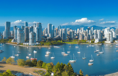
Vancouver has some iconic places that you must visit when you travel there. If you are still wondering, is Vancouver safe? The natural beauty of the city will draw you in but there are outdoor activities as well. It is one of the cheapest places to travel around the world in 2025! You must consider the safety considerations that we are sharing with you here. Be it the parks or museums, you must be aware of the policies. You have to be cautious of the wildlife when going on a hike or trail in the forests around Vancouver. The weather is a little unpredictable, so carry an umbrella and wear waterproof shoes. When you are walking or driving, you need to be careful if the conditions become too cold or falling snow. Read the article to know more about the safety tips to be careful and enjoy your trip to Vancouver. Want to know, Is Vancouver Safe for a Traveler? If you want to know if Vancouver is safe to visit, these are the safety tips that will help you in being aware. Knowing the safety tips will help you enhance the overall experience. Yes, there are some property crimes and petty theft in the city, however, the rest you can avoid if you are careful. You should try the basic personal awareness and safety tips necessary to keep yourself safe. If you are traveling with family, you should keep your children close and educate others to be aware of petty crimes. However, if you are alone, it is better if you can store your luggage in the online applications offering these services. You also need to know the essential safety supplies to pack on your backpacking trip. Safety Tips to Keep in mind when visiting Vancouver Some of the tips that you must keep in mind when you first arrive in the city are here. In Vancouver, you will be blown by the scenic beauty, walking around and exploring the beautiful views of the ocean from the West End and the mountains downtown. However, be careful of aggressive thieves or attackers. Pickpockets are not prevalent however, if you visit crowded places like Granville Island, you might face one. So, be careful. Try to keep your bags close and not leave them unattended. When planning to visit Vancouver, you need to research the city, its streets, and its neighborhoods. You might not feel safe in Downtown Eastside however, other areas such as Kitsilano, Yaletown, and Downtown are perfectly safe, and quite a vibrant place to visit. Safe Accommodation in Vancouver Let me share with you some of the safest accommodation options that will keep you safe and give you the comfort you need. I will also try to keep the budget in mind when mentioning the places you must consider when booking your accommodation. Yaletown – the waterfront views are to die for in this area, so if you are a nature person, this is the neighborhood for you. Additionally, the place gives off upscale vibes, being both stylish and safe for tourists. Downtown Vancouver – if you are traveling for the first time to Vancouver, I would suggest you book your accommodation here. It is ideal for first-time travelers as they can access the Vancouver City Center and other major attractions of Vancouver. The place is well-lit and well patrolled thus, you can easily come and go based on your itinerary. North Vancouver – if you love the outdoors, this place is perfect for you. This neighborhood is closer to forests and outdoors as you can easily go skiing or hiking from here. With a wide range of outdoor activities, you will enjoy the most in this area. You keep in mind the crucial hiking tips to ensure your safety while hiking. Kitsilano – the neighborhood is quite family-friendly hence; you can easily book rooms to stay here. The place is also quite close to the beaches so, with the laid-back atmosphere, you can relax here, and go on to enjoy your trip. Awareness of the Cultural Changes Considering it is a different place; Vancouver is an amalgamation of several cultures. Hence, you need to be aware of the multicultural identity and the integration of progressive values, thus making it a better destination to visit. Learn about these tips here: Language – the primary language is English however, you might hear several other languages because there is a diverse population in the city. You must be respectful to all and not insult them, either by words, actions, or gestures. Etiquette – personal space and politeness are normal etiquette everywhere, not just in Vancouver. As an individual, you must be thankful for little gestures or help from strangers. Thus, holding the door or saying “thank you” will go a long way to make your stay safe and memorable. Scams – Scams are common everywhere, be it Vancouver or any other place. You must be conscious of your surroundings, and beware of unsolicited offers, especially in crowds. Also, don’t buy tickets or accept any services without a trustworthy source. Dress Code – The city is known for its unpredictable weather, so layering is the most important step. You will see a lot of locals doing the same hence, casual attire is quite acceptable. But try to wear clothing you are comfortable with and not force yourself into something uncomfortable. There is a municipal bylaw in Vancouver that prohibits people to smoke close, at least 6 meters from a window or doorway. Do not prefer smoking cigarettes or look down upon those who do. You must not smoke in public parks because locals might raise their voices against it. Safely Navigating the City When you are visiting Vancouver, let me share with you some of the easiest ways to get around safely. You need to explore the city safely following these guidelines. You can also consider these smart travel solutions so that you can enjoy your trip! Try to travel mostly by public transport because it is the safest, however, try to avoid empty stations at night. The TransLink operates SeaBuses, SkyTrains, and buses through which you can easily move around. Did you know Vancouver is a bike-friendly city? You can easily ride cycles when visiting Vancouver especially because there are dedicated bike lanes. There is an online application Mobi which offers bike-sharing services. During rush hours, Vancouver can easily be a difficult place with the traffic. Additionally, there are cyclists as well as pedestrians hence, if you are driving, you need to be a little careful. It can be worse when it comes to crossing the Lions Gate bridges or the Second Narrows, plus, at the weekends, it is worse. That is when you need to try either the Swartz Bay ferry or Vancouver Metro. Wrapping Up! Vancouver as a city is not dangerous, however, you need to be careful and attentive to any place you travel. There is a possibility of facing some of the poorest people around town so there might be a possibility of petty theft or crime. And yet, remarkably it is safer when it comes to violent crimes. Comment below on what you think about Vancouver or are you too scared to visit the place? Do you think I have missed any safety tips that might be helpful for others when visiting Vancouver as a traveler. Also read Top 10 Most Popular Paraguay Food That You Must Try. Top 13+ Famous Wonders Of India That You Must Visit.


Your perspective on this issue is truly refreshing. Thank you for shedding new light on this topic!