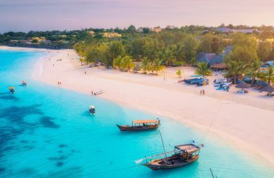
There are many different beaches in Washington, including those on the Puget Sound, Pacific Ocean, peninsulas, lakes, and islands.
Washington beaches feature grassy dunes, pebbles, rocks, or sand and offer activities like swimming, boating, wildlife observation, tidepool exploration, and gathering driftwood or seashells.
Beachgoers may be kept on the shore by the chilly water, but sunsets on Washington’s west coast provide the ideal cap for a day at the beach.
The most prevalent type of beaches in Washington, Puget Sound, are gravel ones, though they can also be found along the coast (such as the Willapa Bay side of Tokeland).
Small-stone beaches aren’t great for volleyball, but they tend to attract more marine life because they offer hiding places from raptors.
They’re a favorite among crabs, and harbor seals graze on mixed gravel beaches.
Beaches in Washington
If you are looking for the best beaches in Washington, then we are listing some of your top options here. So, look at all the names we are dropping.
Golden Gardens Park, Seattle
With views of Puget Sound and the Olympic Mountains, the 80-acre Golden Gardens Park is home to one of the largest beaches in the Seattle area.
Swimming is available at the sandy beach, and hiking, volleyball, and fishing, as well as water sports like sailing, canoeing, and kayaking, are all very popular.
On the beach, there are fire pits and a one-acre dog off-leash area available.
This urban park is about five miles to the north of Seattle’s downtown. Visitors can enjoy the grass and sand areas, and lifeguards are on duty during the summer.
In addition to tennis courts, an indoor pool, picnic areas, equipment rentals, restrooms, and a historic bathhouse, the park has basketball courts.
A 2.8-mile path encircling the lake is popular among bikers, skaters, walkers, and joggers.
Madison Park Beach, Seattle
Northeast of Seattle’s downtown, this little park on Lake Washington’s edge offers a small sandy beach, grassy area, parking, tennis courts, restrooms, and lifeguards in the summer.
There are benches and a walking path nearby, and guests can go shopping or eat at neighborhood eateries.
Alki Beach, Seattle
Alki Beach is a 2.5-mile sandy beach located on Elliot Bay in West Seattle, along with a corresponding long pedestrian walkway.
One of the eight lighthouses on Puget Sound is a replica of the Statue of Liberty, and it is open for tours. From Memorial Day weekend through Labor Day, beach fire pits are open.
There are picnic tables, parking, as well as restrooms.
Madrona Park, Seattle
Madrona Park, which is on Lake Washington’s western shore, has picnic spaces, a bathhouse, a swimming beach, and parking.
Together with a grassy shoreline, hiking trails, and views of Mount Rainier, there’s a jogging path alongside the lake.
During the summer, lifeguards are on duty, and the beaches are open until Labor Day. Madrona Park is one of the least explored beaches in Washington.
Jackson Beach, San Juan Island
Approximately two miles from Friday Harbor’s downtown, this lengthy sandy beach is open all year round. A small dock, volleyball courts, fire pits, barbecue grills, restrooms, and a picnic area are all present.
The presence of bioluminescent dinoflagellates, which glow in the dark when a kayak paddle touches them, is an exciting feature.
This phenomenon is only available to guided groups. Individuals must make reservations for evening events as the park is closed to visitors.
Fort Worden, Port Townsend
The sandy beach, which is part of Fort Worden State Park on Puget Sound, has access to a boat ramp, kayak and canoe rentals, and views of the Northern Cascades.
Part of the original concrete fortifications still stands from the once-powerful military fort that once guarded the city.
So, the exhibits at the Marine Science Center are open to visitors in the summer. There are campgrounds close by, and you can see the lighthouse from the outside.
Long Beach, Long Beach Peninsula
Long Beach calls itself the “World’s Longest Beach.” It stretches 28 miles along its shoreline and is in Washington’s southwest.
Hikers, bikers, as well as walkers can enjoy views of the surrounding landscape and art installations along the 8.5-mile Discovery Trail. A half-mile boardwalk leads down to a grassy dune.
The broad, level sands of the peninsula taper off to the horizon in both directions. It is battered by Pacific waves that are nearly always too erratic and too chilly for swimming.
It boasts the best boardwalk in the state. The 8.5-mile Discovery Bike Trail meanders among sand dunes, public art, and the restored whale bones.
Long Beach’s fine, soft sand is created by the addition of clay and silt from the Willapa Bay’s large mud flats. It is paler than beaches in Washington near river mouths because of its higher quartz concentration.
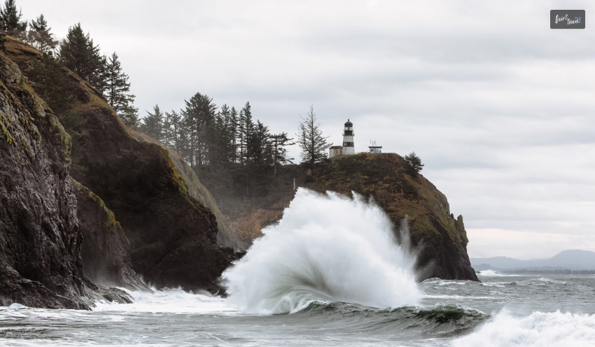
Cape Disappointment State Park, Long Beach Peninsula
Sandy beaches in Washington, with breathtaking views of Baker Bay and the Pacific Ocean, can be found in the park.
Two operational lighthouses, a military fort, as well as the Lewis & Clark Interpretive Center, which tells the history of Cape Disappointment, are all part of the historic area.
In addition to building sandcastles and driftwood forts, beachgoers can hike through coastal forests and explore tidepools. The water is a little too cold for swimming, but there’s still plenty to do.
This miniature version of Waikiki Beach seems to have welcomed all visitors since it opened.
Despite how beautiful the cove and black river sand are, the name doesn’t refer to a paradisiacal place but rather to the passing of a Hawaiian sailor who lived nearby.
Half Moon Bay, Westport Light State Park, Westport
The 560-acre day-use park has grassy dunes and beaches on Half Moon Bay and the Pacific Ocean, as well as picnic areas, restrooms, grills, a lighthouse, and a coastal forest.
Moreover, Half Moon Bay and the Pacific Ocean have a 1.3-mile paved path dividing them. Activities nearby include fishing, surfing, as well as exploring the Westport Lighthouse.
Moreover, on the beach, dogs are welcome, and camping is available close by.
Griffiths-Priday Ocean State Park, Ocean Shores
The mouths of the Copalis River and Connor Creek are where you’ll find this state park on the Pacific Coast.
Walking trails, a boardwalk, and grassy sand dunes all lead to the sandy beach, which is frequently empty. Seashells, migrating birds, and the neighboring Copalis National Wildlife Refuge are all attractions for nature enthusiasts.
Many people come here to dig for shellfish, and dogs are welcome. There are picnic tables and restrooms.
Luther Burbank Park, Mercer Island
Nearly a mile of Lake Washington waterfront is available for swimming, boating, and fishing at this 77-acre park.
There are walking trails, tennis courts, picnic areas, grills, a kids’ playground, and restrooms (during summer). From October through April, dogs on leashes are welcome on the beach.
Mercer Island also offers off-leash areas. You can check out Luther Burbank Park if you are looking for quieter beaches in Washington state.
West Beach and Sunset Beach, Washington Park, Anacortes
Located in Washington Park on the western tip of Fidalgo Island along the Swinomish Channel, there are two beaches- West Beach and Sunset Beach.
There are picnic areas, restrooms, a playground, a boat launch, and beachside fire pit barbecues at Sunset Beach. It comprises 220 acres.
West Beach has campsites, a small rocky area, tide pools, and breathtaking views.
Lake Sammamish State Park, Issaquah
This day-use park has a playground, walking trails through forests and wetlands, and two lakefront beaches.
At Tibbets Beach, you can rent equipment for water sports, reserve an outdoor kitchen, and have a picnic area. This 530-acre park hosts annual events, including boat parades, concerts, and nature walks.
Dogs on leashes are allowed in the park but not on areas designated as swimming beaches. If you are looking for beaches in Washington, Lake Sammamish is another option.
Idylwood Beach Park, Redmond
The Idylwood Beach Park is on the northwest coast of Lake Sammamish and has a lot to offer. It has a bathhouse, swimming beach, picnic tables, restrooms, a small boat ramp, a fishing pier, and picnic shelters.
The park sprawls over 17 acres of land. It provides the only free recreational access to Lake Sammamish. This popular park also has playground equipment, volleyball courts, fishing, and barbecue pits.
Cama Beach
On Camano Island, the beach is all about boats. The most well-liked sound-front spot has a parking lot uphill and is hidden from view.
Situated near the water, the Center for Wooden Boats and its vintage vessels take center stage. It is encircled by luxurious cedar cabins that resemble a sleepaway camp.
The place rents out boats and hosts weekend workshops for building toy boats. Because of the extremely rocky shoreline, transport by sea is the preferred option.
North Bay
This park on San Juan Island, like many other beaches in Washington, is home to bleached-white driftwood.
It forms a barrier between a grassy bluff and dark, dense sand. Guided groups are usually the only ones allowed after the park closes at dusk.
North Bay, located just south of Friday Harbor, just outshines everything else. At night bioluminescent dinoflagellates light up the water when in contact with a kayak paddle, making the trip even more memorable.
Kitsap County Park’s Beach
This Kitsap County park’s beach is a three-quarter mile walk (all downhill, but that means an ascending stroll on the return trip).
The waves are very calm because Vashon Island feels like it is almost touching the narrow finger of Colvos Passage. The required hike keeps the beach comparatively deserted.
Crescent Bay
Imagine the craggy islands along Washington’s coast, minus the ferocious waves. The most striking areas of this county park on the northern edge of the Olympic Peninsula are tucked inland.
Moreover, it has old military bunkers buried deep under the overgrown forest, and many of them are concealed behind overgrown trails.
Tide pools form the eastern end of the water, and a sandy stretch hugs the relatively calm Crescent Bay. Far off in the distance is Vancouver Island.
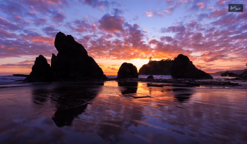
Quileute Oceanside Resort
Sea stacks, or little islands with a few scraggly trees at the top and basking sea lions at the base, are due to rock columns just offshore.
About two miles north of Rialto’s parking lot, Hole-in-the-Wall is a naturally occurring sea arch in a headland on this section of the national park that is only accessible at low tide.
The Quileute Oceanside Resort is next to La Push’s dully named First Beach, south of Rialto.
Olympic National Park
Even with its magnificently isolated beaches, the Olympic National Park still has some gems near the parking lot.
Ruby Beach’s broad sands are just a quarter mile from Highway 101, and the distance between pavement and dunes at Kalaloch, to the south, is just a few feet.
In addition, the Tower of Wisdom is collapsing. It’s one of the few spots in the park where dogs are allowed, so keep an eye out for bald eagles and look down on leash-wearing pets.
Tokeland
Smugglers used the hotel’s hidden spot behind the fireplace to hide undocumented workers, and there are plenty of antiques and rooms with floral wallpaper in this 127-year-old establishment.
The Victorian-era farmhouse is one of the few businesses in a quiet residential waterfront community, and it looks out over the serene, kelp-filled coast of Willapa Bay.
Seaview
The Depot restaurant is a welcome diversion on a coast popular for bins of saltwater taffy and hand-caught razor clams rather than for fine dining.
The old Clamshell Railroad station has a lot of tables, with chef as well as owner Michael Lalewicz cooking up local oysters as well as combining wild razor clams and Willapa Bay clams for a flavorful chowder.
Wrapping Up
Washington’s beaches, with their unparalleled beauty and ecological significance, stand as a testament to the delicate balance between human joy and environmental responsibility.
So, whether you’re drawn to the windswept shores of the Pacific or the calm bays of the Salish Sea, Washington’s beaches invite all to connect with nature and savor the timeless allure of the coastal landscape.
The unmatched beauty, as well as the ecological significance of Washington’s beaches, serve as a testament to the fine line that must be drawn between environmental responsibility and human enjoyment.
Therefore, beaches in Washington invite everyone to connect with nature and enjoy the timeless allure of the coastal landscape, whether they are drawn to the windswept shores of the Pacific or the serene bays of the Salish Sea.
Abdul Aziz Mondol is a professional blogger who is having a colossal interest in writing blogs and other jones of calligraphies. In terms of his professional commitments, he loves to share content related to business, finance, technology, and the gaming niche.
If you're contemplating a significant transformation in your life, you might discover that relocating to a different country could be the best decision for you. Whether you're pursuing a professional opportunity, seeking personal growth, or looking to spice up your life, you're unlikely to regret this decision.
If Paris, the city of lights, is your chosen destination, get ready for an exciting adventure. However, before you start packing your bags and hopping on a plane, there are several factors you need to consider to ensure a smooth transition. If you're interested in discovering the essentials of moving to Paris, you've come to the right place.
Keep reading to learn how to begin a new chapter in Paris, and embrace the romantic Hollywoodian dream as the lead character.
Find a house
Finding a place to live is essential when moving to Paris. The city is divided into twenty districts, known as arrondissements, each with its unique character and atmosphere. The first step is to determine your budget and research the different arrondissements that fit your criteria.
Renting an apartment in Paris can be a complicated process, especially if you don't speak French. It's highly recommended that you seek the assistance of a bilingual real estate agent or a property lawyer in Paris.
They can help you navigate the legalities of renting an apartment in France, ensure that all the necessary documents are in order, and help you negotiate the terms of the lease.
Settle into the city
Once you've secured your accommodation, the next step is to settle into the city and make the most of your new surroundings. Paris is a city full of history, art, culture, and gastronomy, and there's always something new to discover.
One of the best ways to get to know Paris is to walk or bike through its best neighborhoods, parks, and gardens. The city has an extensive public transportation system, including trams, buses, and the very famous metro system of Paris.
The metro system is not only the most used and efficient mode of conveyance and transportation, but it is also a tourist attraction in itself. This is because of its stations that are beautifully designed and art installations that are unique.
Learn French
Learning French is crucial to fully immerse yourself in Parisian culture. French is the official language of the country of France. While it is true that many Parisians can speak English fluently, if you know some French, it will make your transition smoother.
You can take a few language classes, join language exchange groups, or hire a tutor in order to practice the language and meet new people. You can enroll in some French online lessons in order to be prepared before moving to the country.
Discover Parisian lifestyle
Paris has a reputation for being romantic, sophisticated, and fashionable. While these stereotypes are not entirely accurate, they do reflect some aspects of the Parisian lifestyle. Parisians value quality over quantity and enjoy spending time with friends and family over long meals and drinks.
They also appreciate art, culture, and intellectual discussions. To fully experience the Parisian lifestyle, consider exploring the city's museums, art galleries, and cultural events. Joining a social club, taking up a new hobby, or participating in community activities can also help you meet new people and integrate into the local community.
Bonus: Should You Settle In Paris?
Paris is most definitely one of the best places to stay in France, if not in the world. Rich in culture and architecture, Paris has endless opportunities for work and life. From companies that pay you hefty amounts to world-class education facilities, there is absolutely no end to the things that you can settle in Paris for.
While it is true that Paris is the fifth largest metropolitan city in the world, this city of the muse has a lot of flaws as well. That is the reason why you should take a look at this part of the blog.
Pros Of Living In Paris
The metropolitan economy of Paris ranks fifth in the world.
The system of public transportation in Paris is extensive.
Paris's nightlife is very active.
Paris has excellent connections to Europe as a whole.
France's largest expat community is located in Paris.
There is a lot to see and do in Paris.
France's most English-speaking population is found in Paris.
Paris is one of the best culinary centers in the world.
Cons Of Living In Paris
The world's second-most expensive city is Paris.
Paris has too many people.
Paris has a lot of traffic.
The Paris metro framework is a labyrinth.
Paris is extremely noisy and chaotic.
It's not always safe in Paris.
Getting to know local people can be troublesome.
Wrapping It Up!
Now that you have reached the end of this blog, I hope that this article has been of help to you. If there are any other queries related to the topic of moving to Paris, please feel free to let me know. All that you need to do is scroll down till you reach the bottom of the page. And I will be there to answer them all for you!
Read Also:
Main Reasons To Travel As A Student
Where Is The Most Popular Spot In The World To Take A Selfie?
Best Places To Visit In South West France
Zanzibar is known for being sloppy when wet and extremely hot in the summer. The protracted rains bring heavy torrential downpours every day, causing high humidity and silty seas to occur between March and early May. With its dry and sunny peak season from June through October on the beach (and in Tanzania's game reserves if you're on a safari first), most vacations to Zanzibar outside of these periods will be nice.
While November and December offer Zanzibar's shorter spells of rain, these typically are isolated showers that won't cause holiday washouts. January to March are likewise dry and hot but a lot quieter. The year-round average temperature is roughly 30°C. Due to the warm waters, minimal wind, and high visibility, the months between March and November are typically regarded as the best for diving and snorkeling.
September through December is the prime time to see whale sharks, reef sharks, and manta rays. If you want to know more details on when is the best time to visit Zanzibar, this article will help you navigate those questions.
Best Time To Visit Zanzibar
Image Source: gumlet.assettype.com
Strictly speaking, the dry seasons of December to February and June to October are the best times to visit the Zanzibar islands. But in general, the beaches on the southern and western parts of the islands are more protected from wind during these months. On the other hand, the wind typically comes from the southwest from June to October. This makes the northern and eastern coasts ideal for holidaying. But in the end, these islands remain at the whim of the ocean, and their weather can be erratic throughout the year. Even in the “dry” seasons, afternoon showers do occur, but they usually last only a few minutes and are refreshingly cool.
It is not an entirely bad idea to travel to Zanzibar during the rainy season when the number of tourists declines, and you will likely find affordable trips and lodging (among those that are still open). The sunsets are known to be stunning. The rain, although severe, is not generally consistent, and delicious pineapples come into season! You might find it tricky to navigate the roads and buses, but things eventually settle.
Wet and dry seasons are Zanzibar's prominent climates, which are influenced by the movements of the Indian Ocean’s rainy season. From November/December to February/March, the northeast monsoon winds, or kaskazi (in local parlance), blow. And from June to September/October, the southwest monsoon winds, also called kusi, blow. There is a brief rainy season (the vuli) in November in addition to the main rains (the masika), which last between mid-March to the end of May.
Weather
Image Source: www.holidaysplease.co.uk
Although it can be reduced by the winds and sea breeze, humidity is relatively high throughout the year. The average daily temperature on Zanzibar Island is roughly 26°C (80°F) from June to October and around 28°C from December to February. However, during the latter period, humidity levels are frequently greater, making temperatures feel hotter. Pemba has a milder climate with a little more rainfall than Zanzibar Island.
The islands are crowded with tourists from outside and expats from Nairobi and Dar es Salaam during major holidays like Christmas and Easter. You can expect crowded flights and increased hotel prices. On the other hand, life moves more slowly as many restaurants and shops close during the Islamic fasting month of Ramadan. The annual Zanzibar International Marathon takes place in the first few days of November. This can be a good incentive for sports enthusiasts, making it the best time to visit Zanzibar.
Festivals
Image Source: www.gallerytours.net
The majority of Tanzania's public holidays are observed on the islands as well. On these days, companies and offices are typically closed, while some tour operators are still open. Some of the public holidays with set dates observed on the island are:
1 January – New Year
12 January – Mapinduzi ‘Revolution’ Day
7 April – Sheikh Abeid Amani Karume Day
26 April – Union Day: Zanzibar and Tanganyika
1 May – Workers’ Day
7 July – Saba Saba (Seven Seven)
8 August – Peasants’ and Farmers’ Day
14 October – Nyerere Day
9 December – Independence Day
25 December – Christmas Day
26 December – Boxing Day
The Muslim holidays of Idd il Fitri, which marks the conclusion of Ramadan, and Idd il Maulidi (also known as Maulidi ya Mfunguo Sita), which commemorates Muhammad's birth, are widely observed and serve as public holidays. These festivals fall 11 or 12 days early each year and have dates that are determined by the lunar calendar. If you are planning to visit Zanzibar in 2024 and want to be a part of their Ramadan, it is set to start on 10 March through 8 April.
Places To Visit
Image Source: zanzibardestination.co.tz
Zanzibar is one of those rare treasures you keep to yourself, as a secret, as a deeply significant memory, and as the most joyful days spent. Now that you know the best time to visit Zanzibar, if you want to know a few places you can check out while visiting, here are a few:
Slave Trade
Image Source: pbs.twimg.com
The Slave Museum is a must-see for anybody interested in learning about Zanzibar's sordid past. The last active slave market in the world was shut down in 1873. You will pass by rooms where slaves were housed before being sold as you move around the museum. To work on plantations, hoards of Africans were first transferred to this island. Slave traffickers utilized the port at Zanzibar as their center of operations to transport slaves to countries including Egypt, Arabia, Persia, and the Ottoman Empire.
Sunset Dhow Show
Image Source: www.tanzaniatourism.com
If you miss taking a Sunset Dhow Cruise on the translucent, emerald seas of the Indian Ocean, your journey to Zanzibar will remain incomplete. The busy bustle of a busy town gradually disappears as the sunset cruise departs the coast that gets replaced finally by the musicians' melancholy ballad of lost love and found romances or a tune played on a taraab, violin, or oud.
The crew will provide you with crackers and your preferred brand of beer or soda. Sip on your drink while you bask in the exotic vibe on the cruise.
Mnemba Atoll
Image Source: www.andbeyond.com
Explore the fascinating marine life at Zanzibar, which is host to more than 400 species of fish, turtles, nudibranchs, and many rare forms of coral, while scuba diving at Mnemba Atoll. If you are lucky, you might see reef sharks, manta rays, and whale sharks. Mnemba Atoll is one of Zanzibar's top locations for water sports while being a conservation area and marine reserve.
Mid-February through mid-May, as well as mid-October to mid-December, are the best times to go scuba diving in Mnemba Atoll since the sea is quiet, and there is high visibility to enjoy the experience even better.
Darajani Market
Image Source: upload.wikimedia.org
A market is a location where we meet new folks, socialize, and engage in addition to trading and selling items. One such location in Zanzibar is the Darajani Market, which serves as the town's main market.
You can find merchants selling everything from Chinese toys and other trinkets to indigenous Zanzibar spices, kofias (Zanzibari hats), and dates while you take a stroll around the streets. You will have an amazing experience wandering the market's winding streets.
Wrapping Up
The best time for either a rustic vacation or participation in Zanzibar activities is during the months of June and October. These are the months of spring in Africa when the weather is mild and delightful. You can also visit this island paradise in the tropics during December and February. Zanzibar experiences hot, dry weather while it is winter in other countries.
Are you planning a visit and want to know when the best time to visit Zanzibar is? Or have you been to Zanzibar recently? Did you like the island? How was your experience? If you have thoughts to share or questions to ask, please leave a comment below. We would love to hear from you!
Read Also:
This Is The Best Time To Visit Iceland & These Are The Things You Should Do!
This Is The Best Time To Visit The Seven Magic Mountains In Vegas!
THIS Is When You Should Visit Maldives!
As a frequent business traveler, you understand the significance of having an efficient suitcase. From traveling for short meetings to attending lengthy conferences, having essential items can make all the difference in how smoothly everything runs.
This blog post offers a complete packing list for business travelers and includes helpful advice to ensure they're fully prepared for their professional adventure.
So grab your suitcase and begin packing like an expert!
How To Pack For A Business Trip
Packing for a business trip requires careful thought to bring everything you need for meetings and presentations while maintaining an attractive appearance.
Here is a step-by-step guide to packing efficiently:
Make A Checklist:
Draft an essential items list that covers clothing, toiletries, electronics, documents and any special items required for meetings.
Check The Weather:
Research the weather forecast for your destination during your trip. This will help you determine the appropriate clothing to pack.
Choose Versatile Clothing:
Opt for versatile pieces that can be mixed and matched to create different outfits. Stick to a color palette that coordinates well. Includes business attire like suits, blouses, dress shirts, slacks, skirts, and comfortable shoes.
Formal Attire:
If you have formal events or meetings, pack appropriate attire such as a formal suit, tie, and polished shoes.
Accessories:
When accessorizing an outfit, bring along accessories to enhance its style. Ties, scarves, belts, and jewelry can all add the perfect finishing touches and complete their style.
Toiletries:
When traveling abroad, travel-sized items such as toothbrushes, toothpaste, shampoo/conditioner/soap, deodorant, razor, and any medications required for your trip are essential.
Electronics:
When traveling for business, always pack all necessary equipment, such as your laptop, chargers, smartphone, and any essential accessories, such as power banks or headphones, that may be needed.
Documents:
Organize and pack essential documents such as your passport, identification card, boarding pass, travel itinerary, business cards, and meeting materials. If you need fresh business cards for networking, you can easily get a custom business card print with Adobe Express, ensuring a professional look. Additionally, digital tools can help convert text to speech, making it easier to review travel details or meeting notes on the go.
Work Essentials:
Include a notepad, pens, and any work-related materials needed for meetings or presentations.
Shoes:
Pack comfortable yet professional shoes that match your outfit. If you're attending formal events, pack appropriate formal shoes.
Outerwear:
Pack a versatile jacket or blazer that complements your business attire. Also, consider packing an umbrella in case of unexpected weather changes.
Gym Gear:
If you plan to work out during your trip, pack gym clothes, sneakers, and any necessary accessories.
Chargers And Adapters:
Ensure you have the right adapters and chargers for the electrical outlets at your destination.
Packing Strategy:
Use packing cubes or folders to organize clothing and minimize wrinkles. Roll clothes to save space and reduce wrinkles.
Check Airline Restrictions:
Familiarize yourself with your airline's baggage allowance and restrictions to avoid surprises at the airport.
Travel-Size Laundry Supplies:
When packing for travel, remember a small bottle of laundry detergent or stain remover in case any laundry needs arise.
Medications:
In terms of medications, be sure to pack sufficient supplies of medicines necessary for the duration of your journey.
Personal Items:
Include items like your wallet, keys, and regularly used items.
Double-Check Before Leaving:
Double-check your checklist to ensure you have everything essential.
Pack Light:
Try to pack efficiently and avoid overpacking. Focus on the essentials to make your trip more manageable.
Business Travel Packing Tips And Tricks
Embarking on a business expedition demands more than a suitcase; it requires a masterful symphony of strategy and practicality. These indispensable tips and ingenious hacks will be your guiding stars, ensuring your seamless and stylish journey.
Strategic Selection Based On Itinerary:
Craft your wardrobe like an artist's palette, with each garment chosen for a purpose. Analyze your Itinerary, from meetings to downtime, and curate outfits that effortlessly transition. Versatility is your ally.
Hotel Amenities As Allies:
Embrace the luxury of your chosen abode. Leverage hotel amenities like laundry services, hairdryers, and irons. Leave these bulky items behind, freeing up precious space in your luggage.
The Art Of Packing Cubes:
Unravel the magic of packing cubes. These versatile compartments can transform chaos into order, granting each item its enclave within the suitcase symphony.
Prioritize Quality Luggage:
Your suitcase is more than storage; it's a partner in your journey. Opt for quality and durability. A well-designed bag can safeguard your belongings and enhance your travel experience.
Medicine And Essentials First:
Begin your packing symphony by arranging essential medications and personal items. Build from this foundation, securing your well-being before diving into other necessities.
Liquid Allowance Awareness:
Navigate the labyrinth of liquid restrictions set by airlines. Prioritize travel-sized toiletries or consider solid alternatives to avoid spillage and streamline security checks.
Virtual Documents And Backup:
Liberate yourself from paper documents. Digitize your essentials – from travel itineraries to business documents. A cloud-based backup ensures access regardless of circumstances.
Minimalist Shoe Strategy:
Shoes are notorious space-hoggers. Choose a versatile pair for formal events and another for casual strolls. Your feet and luggage will thank you.
Clever Clothing Coordination:
Opt for a color scheme that allows mix-and-match possibilities. Each garment should complement others, maximizing outfit options while minimizing the number of pieces.
Roll, Don't Fold:
Tame clothing in bulk with the roll, not fold technique. This minimizes wrinkles and opens up additional space for more necessities.
Elegance In Accessories:
Elevate your outfit with carefully selected accessories. A statement tie, scarf, or jewelry can transform a simple attire into an impressive ensemble.
Power Of Reusable Bags:
Pack a collapsible tote bag. It's ideal for unexpected purchases, separating dirty laundry, or accommodating an impromptu excursion.
Backup Charging Arsenal:
Keep a dedicated charging kit with spare cables, a power bank, and adapters. You won't scramble for power amidst vital engagements.
Emergency Clothing Stash:
Unexpected spills or mishaps are inevitable. Pack a compact emergency clothing kit, including spare socks, a shirt, and an accessory to freshen up quickly.
Tech Armor For Gadgets:
Your device is vital. Shield them with protective cases and sleeves to ensure they reach your destination unscathed.
Travel Insurance: Non-Negotiable:
Protect your journey with comprehensive travel insurance. A safety net is invaluable, whether for trip cancellations or medical emergencies.
Decanting For Delicate Liquids:
Opt for small, leak-proof containers for cosmetics or toiletries prone to leakage. This ensures your essentials remain intact and your luggage spill-free.
Tailored To Tees:
Pack clothes that align with your style. Feeling confident in your attire can significantly impact your overall outlook and performance.
Digital Detox Deliberation:
Reflect on the necessity of every tech gadget. A temporary digital detox can foster mindfulness and enhance your experience.
Return With Room:
Leave room in your luggage for souvenirs or potential acquisitions. A well-planned packing strategy ensures your journey concludes with a sense of accomplishment.
Travel with Travel-Wise!
The leisure trend has rapidly gained popularity as an effective way to combine business travel with pleasure. An itinerary that provides both productive work time and leisure activities is critical to maximize the experience of any trip.
Travel-Wise provides an intuitive trip planner that makes travel plans tailored to your preferences easier than ever, enabling you to combine productivity with enjoyment for any upcoming business trip seamlessly.
With Travel-wise on your side, creating the ideal business trip is now more manageable than ever!
Read Also:
How To Save Money On A Trip To Abu Dhabi
7 Tips To Make The Most Out Of Your Trip To Gatlinburg


 Related