Be Soothed And Meet History At Hot Springs National Park
BY Sibashree Aug 20, 2024
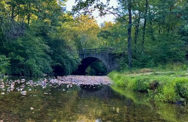
The Arkansas Hot Springs National Park is a place where stories and histories are intertwined with natural abundance and unique geological features. Home to 47 hot springs, this national park has been a place of healing and relaxation. These springs offer the ultimate spa treatment after you complete arduous hiking through the trails. Are you ready to indulge in a therapeutic experience at this national park known as the American Spa? Let’s take a deep dive. Also, I have grabbed this opportunity to talk about the rich history of the park. Know The Hot Springs National Park History And Culture The 5,500-acre landscape of the Hot Springs National Park tells us many tales from the trails and springs. This park has seen novaculite extraction by American Indians for thousands of years, as well as The Great Fire of 1878. Even before the park’s designation as a Hot Springs Reservation in 1832, historic events like the Dunbar-Hunter Expedition took place here. Many historic places in the park, including the Hot Springs Mountain Tower, Arlington Lawn, and Stonebridge Area, have been narrating the stories of this park for centuries. Hot Springs Mountain Tower Built in 1983, Hot Springs Mountain Tower is a great place for visitors to enjoy the panoramic view of the park and the surrounding area from a 1,256 ft height. Don’t miss to catch a glimpse of the Ouachita Mountains from the open-air upper deck of the tower. The air-conditioned lower observation deck offers you the opportunity to explore exhibits related to the history of the locality and the park. Also, if you want to collect souvenirs, you can visit the gift shop at the base of the Hot Springs Mountain Tower. This tower was first built as a wooden structure in 1877 by Enoch Woolman. Further, in 1906, a new steel tower was built, and it was known as Rix Tower after Charles N. Rix, the then-president of Arkansas National Bank. However, the Rix Tower was taken down in 1971. Bathhouse Row The Bathhouse Row is probably the most iconic and visited place in the Hot Springs National Park. It has 8 bathhouse buildings, all of them built between 1892 and 1923, adding to the historic and architectural value of the park. These eight bathhouses are: Lamar Bathhouse Buckstaff Bathhouse Ozark Bathhouse Quapaw Bathhouse Fordyce Bathhouse Maurice Bathhouse Hale Bathhouse Superior Bathhouse In 1987, Bathhouse Row with Grand Promenade became a National Historic Landmark District. Arlington Lawn The Arlington Lawn gets its name from the presence of the first two luxurious versions of the Arlington Hotel present here. The first version of the hotel was built in 1875, and a second or grander version replaced it in 1893. The second version had a glorious run until 1923 when a fire broke it down. In 1925, the third Arlington Hotel (which you can see now) came up an unbelievable 500-room accommodation. Whittington Park Whittington Park got its name from Hiram Abiff Whittington, an early resident of Hot Springs. The greenway stretches along Whittington Creek, which stands between Sugarloaf Mountain and West Mountain. Constructed in the late 1890s, Whittington Park was initially called Whittington Lake Reserve. You can enjoy a relaxing walk through this tree-shaded greenway. Stonebridge Area The Stonebridge Area is the best spot in the National Park to watch turtles. You will also see a waterfall area carving through step-like structures in the rocks. Further, Lake Lillian, now known as Ricks Pond, is here with its tranquil beauty and turtles floating in the water. What Is Hot Springs National Park Famous For? Known as the American Spa, Hot Springs National Park has 47 natural hot springs. Since the early 1800s, people have been visiting this park to soak in the hot and cold springs here. Further, thanks to the healing geothermal waters here, bathhouses and a full-fledged bathing industry were built here. The average temperature of the bath springs water here is 143° Fahrenheit. You can soak in the springs in the Buckstaff and Quapaw bathhouses, as there are no opportunities for soaking in the water outdoors. You can even drink the water from these springs, and the geothermal water of the springs has healing properties. Hot Springs In The National Park Here are some of the hot springs in the national park. You will find hot springs In front of the Libbey Memorial Physical Medicine Center and the National Park Service Administration Building on Reserve St. Visit the Bathhouse Row and find the hot springs between the Hale and Maurice Bathhouses. You will find the Noble Fountain at the Grand Promenade south entrance on Reserve St. If you want to touch the geothermal water of the springs, you can visit the shallow pool where the Display Spring falls. Cold Water Spring Fountains Happy Hollow and Whittington Spring are two cold water spring fountains in the national park. The origin of the Whittington Spring is the West Mountain, and the Hollow Spring comes from the North Mountain. Hiking And Camping In Hot Springs National Park Camping and hiking are two of the most fascinating things to do in Hot Springs National Park, Arkansas. Hiking In Hot Springs National Park Hot Springs and North Mountain Trails and West Mountain Trails are the two most popular destinations in the park for trekking. However, there is also a Sunset Trail, which is longer and passes through the remote areas of the park. Hot Springs And North Mountain Trails Along with the most amazing scenic view, these trails have highlight points such as Stephen’s Balustrade or the Grand Staircase, Gulpha Gorge Campground, Hot Springs Mountain Drive, and Fordyce Bathhouse. West Mountain Trails If you want to explore the vivid wildlife of the Hot Springs, you will have to take the West Mountain Trails. Find the trails through the Canyon Trailhead and Whittington Park. Sunset Trail The longest in the Hot Springs, the Sunset Trail, is a straight 10-mile hike. Also, if you want to complete the loop, you will have to cover 15-17 miles. The best thing about this trail is that it takes you to places less trodden by in the park. Further, hiking in the long trail will be broken into three sections: West Mountain, Sugarloaf Mountain, and Stonebridge Road. Camping In The Gulpha Gorge Campground This campground is most suitable for tents and RVs or recreational vehicles. Basic amenities like water, electricity, and sewage are available at the campground. Further, there are facilities like pedestal grills and picnic tables. You can stay for a maximum of 14 days at a stretch in the camp. In addition, the park authority does not allow camping for more than 30 days in a calendar year. Final Words The Hot Springs National Park has been consistently getting more than 2 million visitors for the last few years. In 2023, 2,502,967 people paid a visit to this park to indulge in the therapeutic experience of the hot springs, explore wildlife, and enjoy hiking. (Source) Further, you can never forget how significant this park is from the perspective of history and culture. Exploring the Stonebridge Area and spending some time in Whittington Park or other historic places in the park will help you learn how American Indians extracted novaculite from this park and made their tools and accessories. In addition, prominent names in American history, such as Dr. Timothy L. Bottoms, Samuel Wesley Fordyce, and Robert Radcliff Stevens, are associated with this popular national park. So, you must visit this national park to enjoy nature at its best and see some pages of history unfurling before your eyes. What do you think of the other national parks in America, like the Biscayne National Park or the Everglades National Park? Don’t forget to share your ideas with us! Hot Springs National Park FAQs How Is Hot Springs National Park Wildlife? The Hot Springs is a crucial sanctuary for vivid animals. The “novaculite outcrops” and “lush creek valleys” make this national park a safe harbor for animals and birds. Overall, this park has more than 50 species of mammals, over 100 bird species, 50+ fish species, and more than 70 species of reptiles and amphibians. The Copperhead snake is the most venomous reptile here, along with other venomous snakes. The park is also replete with lizards, frogs, salamanders, and turtles. Bluegill and banded darter are some common fish in this national park. Further, this park is home to mammals like groundhogs, white-tailed deer, and squirrels. Moreover, pigeons, doves, falcons, herons, vultures, owls, and many other birds make this park delightful. Also, watch out for the colorful butterflies and fireflies in the park. By the way, did you know that Arkansas has more than 5,000 species of moths and butterflies? What Are The Best Hot Springs National Park Activities? The most amazing thing to do at Hot Springs National Park is to soak in the hot springs and indulge in a therapeutic experience. The Buckstaff Bathhouse and The Quapaw Bathhouse offer you the most relaxing time. Further, you can explore 26 miles of hiking trails in the park and enjoy biking to the North and West Mountains. You can take these rides on bicycles or e-scooters. Also, if you are a birder, you will get to see great blue herons, vultures, falcons, and many other birds in the national park. Shopping and exploring the Mid America Science Museum are some other activities to do when you are at the Hot Springs. What Is The Hot Springs National Park Size? The Hot Springs National Park stretches across 5550 acres. As one of the oldest national parks in the USA, this national park was designated in 1921. You will find many hiking trails and as many as 47 natural hot springs in the national park. The campground, visitor center, and gift shop further make it a place of versatile encounters with nature and history. Hot Springs and North Mountain Trails, and the West Mountain Trails are the most concentrated trekking zones in the park. However, if you want to explore more remote parts of the park, you can surely take the longer Sunset trail. Also read Why Include Whale Watching In Your LA Itinerary. Traveling On A Budget: Tips For Affordable Adventures. From Cocktails To Kickflips: Must-Try Activities In San Diego.

