


 Related
How to Stay Safe in New Orleans: A Traveler’s Guide
BY Ankita Mar 28, 2024
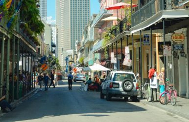
Welcome to New Orleans, a city of vibrant culture, rich history, and endless entertainment. Safety is likely on your mind as you plan your visit to the Big Easy. "Is New Orleans safe?" you might ask. If you have read my blog on the best time to visit New Orleans, you must have noted how I have crafted this travel guide to ensure you have a delightful and secure experience in this iconic city. So, if THAT is something that you are wondering, I have you covered! Let's dive into the safest spots and tips for a worry-free adventure. Is New Orleans Safe to Visit! New Orleans, like any major city, has areas that are safe and others that are less so. It's generally safe for travelers, especially in well-trafficked regions like the French Quarter, Warehouse District, and Uptown. However, the city does have a higher violent crime rate compared to the national average in the United States. It's important for visitors to stay aware of their surroundings, take common-sense precautions, and stay informed about the areas they plan to visit. For a safe and enjoyable trip, consider exploring neighborhoods such as Uptown, including Audubon Park and Magazine Street, and Lakeview and Lakeshore. Though petty theft can occur, the French Quarter is bustling with tourists and generally considered safe. Visiting the beautiful cemeteries with a tour guide is something that I would definitely recommend. This is due to occasional robberies and muggings. Safest Places to Visit in New Orleans Here are some of the safest places are discussed below where you can visit on your tour to New Orleans. The French Quarter: The Heart of New Orleans is Your Safe Haven The French Quarter, the pulsing heart of New Orleans, is a melting pot of history, culture, and festivity. This iconic neighborhood, also known as the Vieux Carré, is where the spirit of New Orleans comes alive with its cobblestone streets, vibrant music, and culinary delights. Historic Jackson Square At the center of the French Quarter is Jackson Square, a historic park that is a National Historic Landmark. Significant structures like the St. Louis Cathedral, the oldest cathedral in North America, and the historic Cabildo and Presbytère buildings surround it. Artists, musicians, and performers line the sidewalks, offering a glimpse into the city's creative soul. The square is a perfect starting point for any visitor, providing a snapshot of the city's rich history and contemporary culture. Bourbon Street: The Life of the Party No visit to the French Quarter is complete without a stroll down Bourbon Street. Known for its lively bars and jazz clubs, it's the epicenter of New Orleans' nightlife. It is also one of the places that is great for couples visiting New Orleans. Here, the sounds of jazz, blues, and zydeco music spill out onto the street, inviting passersby to join the dance and soak in the festive atmosphere. Culinary Adventures The French Quarter is a food lover's paradise, offering a taste of authentic Creole and Cajun cuisines. The neighborhood showcases New Orleans ' gastronomic excellence from the famous beignets and café au lait at Café du Monde to the exquisite seafood gumbo at award-winning restaurants. Royal Street: An Artistic Haven Parallel to Bourbon Street is Royal Street, a quieter but equally charming avenue known for its art galleries, antique shops, and boutiques. It's the perfect place to find unique treasures, from vintage jewelry to original artwork, and to experience the more refined side of New Orleans' culture. French Market: Shop and Savor The French Market is America's oldest public market and has been operating for over 200 years. Visitors can browse through various goods, from local crafts to fresh produce, and enjoy the lively atmosphere. The market also hosts a flea market, where you can find an eclectic mix of items and souvenirs to take home. Cultural Museums The French Quarter is home to several museums that delve into the city's diverse heritage. The New Orleans Jazz Museum celebrates the birthplace of jazz. At the same time, the Voodoo Museum offers insights into the mysterious and often misunderstood religion that has been a part of the city's fabric for centuries. Riverfront Relaxation The Mississippi Riverfront is a stone's throw away from the bustling streets of the French Quarter. Visitors can take a leisurely walk along the Moonwalk, enjoy a steamboat cruise, or simply sit and watch the river flow by, offering a moment of tranquility amidst the excitement of the city. Garden District: Strolling Through Elegance, Serenity, and Safety The Garden District of New Orleans is a visual storybook of Southern charm. It is a neighborhood where the beauty of the past lingers amidst the vibrancy of the present. With its lush greenery and grand antebellum mansions, the district invites visitors to step into a world of historical elegance and tranquility. Strolling Through History A walk through the Garden District is a journey back in time. The well-preserved mansions, each with its own story, are architectural gems ranging from Greek Revival to Victorian styles. The famous Lafayette Cemetery No. 1, the resting place of many notable figures, offers guided tours that reveal the history of the city through the lives of its past residents. Magazine Street: Shopper's Delight Magazine Street, the district's commercial heart, stretches six miles and is lined with boutiques, art galleries, and antique stores. It's where you can find everything from high-end fashion to quirky souvenirs, making it a perfect spot for window shopping and finding that special keepsake. Culinary Experiences The Garden District's dining scene is as diverse as its architecture. The area boasts some of the city's best restaurants, from cozy cafes to fine dining establishments. Indulge in traditional Southern cuisine or explore contemporary dishes that tell the story of New Orleans' culinary evolution. Commander's Palace: A Gastronomic Landmark No culinary tour of the Garden District is complete without a visit to Commander's Palace, a turquoise and white Victorian marvel known for its Creole cuisine and the birthplace of the jazz brunch. This iconic restaurant has been a local favorite since 1893 and continues to be a culinary beacon in the city. Arts and Culture The district is not just about historical sights; it's also a hub for arts and culture. The Ogden Museum of Southern Art and the Contemporary Arts Center are nearby, showcasing the region's art and offering a glimpse into the creative spirit of the South. Relaxing in Audubon Park The nearby Audubon Park offers a serene escape for those seeking a natural retreat with its ancient live oaks, tranquil lagoons, and the Audubon Zoo. It's a place where locals and visitors alike come to unwind, picnic, and enjoy the outdoors. Architectural Tours Several companies offer architectural tours of the Garden District, providing insights into the history and design of the neighborhood's most famous homes. These tours are a great way to learn about the district's development and the stories behind its stately facades. Mardi Gras World: Behind the Scenes While not located within the Garden District, Mardi Gras World is just a short ride away and offers a unique experience. Here, visitors can see the artistry and craftsmanship that go into creating the floats and costumes for New Orleans' most famous celebration. City Park: Your Ultimate Family Place! City Park in New Orleans is an expansive canvas of outdoor pleasures and cultural treasures, offering diverse activities for all ages. Spanning 1,300 acres, it's one of the largest urban parks in the country, inviting visitors to immerse themselves in nature, art, and recreation. Outdoor Adventures Picturesque waterways, perfect for boating and kayaking, crisscross the park's vast green spaces. With rentals available, you can paddle through the serene bayous or enjoy a romantic ride in an authentic Venetian gondola. For those who prefer land over water, the park's biking trails offer a scenic route through its lush landscapes. Botanical Beauty The New Orleans Botanical Garden is a living exhibit of the city's floral diversity, with over two thousand plants arranged in themed gardens. Visitors can wander through the English garden's orderly beauty or find tranquility in the Japanese garden's bamboo groves. The garden is a testament to New Orleans' temperate climate, which keeps the city blooming year-round. Artistic Encounters The New Orleans Museum of Art (NOMA), located within the park, houses an impressive collection of fine arts. The adjacent Sydney and Walda Besthoff Sculpture Garden features over 90 sculptures set against a backdrop of pines, magnolias, and live oaks, creating a harmonious blend of art and nature. Family Fun City Park is a haven for families, with attractions like Storyland, a fairytale-themed playground, and Carousel Gardens Amusement Park, home to a century-old carousel. The park also hosts the Train Garden, showcasing miniature trains amidst meticulously crafted cityscapes. Recreational Activities Sports enthusiasts can enjoy the park's tennis courts, golf courses, and disc golf courses. Fishing is a popular pastime at the park's Big Lake, where you can also find walking and jogging paths for a leisurely day out. Couturie Forest For a wilder experience, Couturie Forest offers a glimpse into the region's natural state before urbanization. It's a 60-acre woodland with trails leading to Laborde Mountain, the highest point in New Orleans, though only 43 feet high. Culinary Delights No visit to New Orleans is complete without indulging in the local cuisine. City Park caters to this with various dining options, including the iconic Café Du Monde. This is the place where you can enjoy café au lait and beignets. Other food venues offer everything from casual bites to gourmet experiences. Seasonal Events City Park is also a venue for seasonal events, from farmers' markets to musical storytimes, ensuring there's always something new to experience. The park's event calendar is filled with activities that reflect the city's vibrant culture and community spirit. Staying Safe: Practical Tips to Have a Safe Stay at New Orleans! When visiting New Orleans, or any new city, staying safe is paramount to ensure a positive experience. Here are some practical tips to help you navigate the Big Easy with confidence. Stay in Well-Lit Areas New Orleans is a city that comes alive at night, but it's important to stay in areas that are well-lit and populated. Avoid walking alone in dimly lit areas, especially if you're unfamiliar with the surroundings. Keep Valuables Secure Pickpocketing can happen in crowded places, so keep your valuables secure. Use a money belt or a cross-body bag that stays in front of you at all times. Be mindful of your belongings in busy tourist spots. Travel in Groups There's truth to the saying "safety in numbers." When exploring the city, especially at night, travel with friends or family. If you're alone, consider joining a guided tour group. Be Aware of Your Surroundings Stay alert and be aware of your surroundings. If you're enjoying the nightlife, keep an eye on your drink and know your limits. It's easy to get caught up in the fun, but staying aware can prevent unwanted situations. Use Trusted Transportation When getting around the city, use trusted transportation options. Rideshare apps are a safe bet, as are licensed taxis. If you're using public transportation, plan your route ahead of time and avoid waiting alone at bus or streetcar stops late at night. Respect Local Customs New Orleans is rich in culture and tradition. Respect local customs and be mindful of your behavior, especially during festivals like Mardi Gras. Blending in and respecting the local way of life can go a long way in keeping you safe. Know Emergency Contacts Familiarize yourself with local emergency numbers and the locations of hospitals or police stations. In case of an emergency, knowing who to call and where to go can save valuable time. Stay Hydrated and Protected from the Sun New Orleans can get quite hot and humid. Stay hydrated, wear sunscreen, and seek shade when necessary, especially during the summer months. Check Weather Forecasts The weather in New Orleans can be unpredictable, with sudden rain showers or intense heat. Check the forecast before heading out and be prepared with appropriate clothing and an umbrella if necessary. Use Common Sense Lastly, use common sense. If something doesn't feel right, trust your instincts and remove yourself from the situation. Don't take unnecessary risks, like taking shortcuts through unfamiliar or secluded areas. Wrapping It Up! So, is New Orleans safe? The answer is both yes and no. The thing is it totally depends on the places that you visit. By following the tips that I have mentioned above in this blog, you can focus on enjoying the rich experiences that New Orleans has to offer, knowing you're taking the right steps to stay safe. Remember, preparation and awareness are your best tools for a safe and memorable trip. New Orleans is a city with soul, and with these tips, you'll navigate it safely and with ease. Remember, the key to a safe trip is awareness and preparation. So, pack your bags, bring this guide, and get ready to experience the Big Easy in all its glory! Read Also: Is Savannah Safe? What You Need To Know Before Visiting! Is San Francisco Safe? THIS Is What You Should Know! Is Cabo San Lucas Safe? – Let’s Find Out!