Related
The Viral Hokkaido Beach: Where Snow, Sand, And Sea Meet (The Myth Vs Reality)
BY Sibashree May 16, 2025
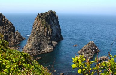
Have you seen the viral social media photos of a lone person walking on a strip of sand sandwiched between white snow and blue surf? Then, I have to burst the bubbles. You are actually looking at the Tottori Sand Dunes in the San’in Kaigan Geopark (Honshu Island). However, the internet has continuously labeled it as Hokkaido Beach. So, while those posts are a myth, Hokkaido genuinely has its own incredible now-meets-sea beaches. Nevertheless, here, I will talk about the “Viral Hokkaido Beach,” and give you a brief comparison showing why and how it is different from the actual Hokkaido Beach. Also, as fantasy is a driving force in Haruki Murakami’s work, the astonishing and actual Hokkaido Beach in Western Japan is nothing short of a dream! It is the land where snow, sand, and sea meet. It’s surreal when you see snow-covered sand dunes appearing before your eyes against the backdrop of the sea. Also, the blocks of ice or jewelry ice in the Tokachi River mouth attract a lot of visitors in the winter. And that’s not all! The beach has sandbars, volcanoes, coasts, and valleys. Do you also want to see Hokkaido beach snow and other unique attractions? You will find all the details in this Tour and Travel Blog. What Is The Best Time To Visit Hokkaido Beach? Hokkaido beach weather remains pleasant throughout the year. So, it’s a year-round destination. However, if you want to witness the golden moments where the sea, sand, and snow meet, you have to plan a trip from December to February. And let me spill the beans for you, Hokkaido Beach is not located in Hokkaido. Moreover, if you especially want to see the phenomenon of ice, snow, and sand meeting, you have to travel to the main island of Honshu. Why Does Hokkaido Beach Have So Much Snow? Hokkaido Beach has so much snow because strong winds blow and shift ice to the beach from late January to February. This ice comes from the frozen chunks of freshwater from the Amur River. Further, during January and February, you will find icebergs in the water and on the beach. How To Reach Hokkaido Beach From Tokyo? The distance between Tokyo and San’in Kaigan Geopark, the home of Hokkaido Beach, is around 657 km. The best way to reach San’in Kaigan Geopark from Tokyo is by taking a bullet train. Take a bullet train from the Tokaido Shinkansen to Shin-Osaka Station. It will take around 2 hours and 30 minutes. Then, travel on the Super Hakuto limited express train for 2 hours and 30 minutes to reach Tottori Station. Finally, you can take a bus from Tottori Station to Hokkaido Beach. However, if you want to really enjoy the scene of ice, sand, and sea meeting, you have to take a cruise ride from Monbetsu, Rausu, and Abashiri. Everything will appear before your eyes as an impossible dream as you see the Hokkaido Beach from the shore or an icebreaker. Do you want some more adventure while exploring the beautiful Hokkaido Beach? You can go for a guided ice walk from Shiretoko. And as you walk toward the beach, you will meet the most fascinating wildlife of the area. The sea eagles and white-tailed eagles, especially, will cross your path many a time. You will see a real-life example of how the food chain in nature works as these birds prey on fish before your eyes. Having said that, you will have to wear a dry suit and snowshoes for the walk. You will rent snowshoes from the Shiretoko National Park Nature Center. Shiretoko National Park Nature Center: A UNESCO World Heritage Site On Your Way To Hokkaido Beach Shiretoko Peninsula, a UNESCO World Heritage Site and a national park, is a favorite of hikers. You can go for a hike through the Furepe Waterfall Trail. The trail passes through a forest, and it opens in a meadow looked over by Mount Io, Mount Rausu, and Mount Tenchosan. Finally, the trail ends with a fascinating cliffside view of Furepe Waterfall. It looks the most fascinating during the winter season. Due to extreme cold temperatures, the water of the waterfall gets transformed into bluish ice. Exploring San’in Kaigan Geopark: Home To The “Viral” Hokkaido Beach San’in Kaigan Geopark is a celebration of the Earth's heritage. Stretching over 245,844 hectares, this Geopark is also home to the Genbudo Cave, “known as the place where the term of Quaternary geomagnetic reversal polarity was first proposed with basalt.” “The San’in Kaigan UNESCO Global Geopark is home to a diversity of geological sites related to the formation of the Sea of Japan, including granite outcrops formed when Japan was part of the Asian continent (70 million years ago), as well as sedimentary and volcanic rocks accumulated when Japan rifted away from Asia (25 to 15 million years ago) to form the Sea of Japan, a geological process still on-going today.”- UNESCO Further, due to the unique geological features, the park is also home to diverse flora and fauna. You will find rare plant species such as Ciconia boyciana, Pseudolysimachion ornatum, and Ranunculus nipponicus here. Moreover, you will be able to see many marine animals and avian creatures in the park. During the winter season, especially, you will spot marine animals such as: Steller sea lions Sea eagles Seals The Steller sea lions come here from the Kuril Islands in the south as the ice starts drifting toward the Hokkaido Beach. Again, irrespective of the season of your visit, you will meet Blakiston’s fish owl in San’in Kaigan Geopark. It is an endangered species. In addition, the nearby mountains here have some of the biggest mammals in Japan. You will find here “Ezo red foxes,” “Ussuri brown bears,” and “Ezo silka deer.” A Honshu Vs. Hokkaido Comparison: The Viral Vs. Actual Hokkaido Beach FeatureThe Viral "Hokkaido Beach" LocationThe Real Hokkaido Winter BeachesActual LocationSan'in Kaigan Geopark (Tottori/Kyoto)Otaru, Toyokoro, and Shiretoko CoastsWhat You SeeSnow-covered sand dunes meeting the Sea of JapanDrift ice, jewelry ice, and snow on black sandBest AccessBullet train from Tokyo to Shin-Osaka and then TottoriFly into Sapporo (New Chitose Airport) The Real Hokkaido Winter Coastline: Ice And Wildlife I have already mentioned that what we actually know as the Hokkaido Beach is actually in Honshu. Still, the actual Hokkaido island also offers dramatic winter coastlines shaped by freezing rivers and Siberian weather. So, you will enjoy the sub-zero beach magic here. Toyokoro: The Shimmering Jewelry Ice Of Otsu Beach On the southeastern coast of Hokkaido, the shoreline of Toyokoro becomes an outdoor gallery of natural crystals from January to February. This amazing natural phenomenon is called Jewelry Ice. The ice here is completely transparent as it originates from the pure freshwater of the Tokachi River. Also, as the river freezes, you will find massive sheets of ice breaking apart and emptying into the Pacific Ocean. Then, the ocean waves tumble and smooth these blocks into rounded and glass-like crystals. The waves further wash the crystals back onto the dark sands of Otsu Beach. Moreover, these ice crystal balls look magical during sunrise or set as the ice blocks refract the amber sunlight like gemstones. The Okhotsk Coast: Ryuhyo Drift Ice And Sea Ice Walkers If you go further north, you will find the Sea of Okhotsk, This coast has an entirely different frozen landscape. Here, you will find Ryuhyo, or drift ice. This is a massive layer of sea ice originating near the Amur River in Siberia and drifting south, completely choking Hokkaido’s northern waters in a vast white sheet by late January. Furthermore, it is the place to indulge in a host of adventurous activities. The Icebreaker Cruises These cruises operate out of Monbetsu and Abashiri. These are heavy-duty vessels crushing directly through the dense sea ice field. Thus, as a passenger, you can enjoy panoramic views of an endless frozen ocean. Shiretoko Ice Walks The Shiretoko Peninsula is a rugged UNESCO World Heritage Site. Here, the ice becomes thick, and the thickness is enough for you to walk on. You can be a part of any guided tour to get equipped with insulated dry suits to safely trek across the floating ice sheets or even float in the freezing coastal waters. Apex Wildlife This icy ecosystem attracts incredible biodiversity. You can regularly spot massive Steller’s sea eagles, white-tailed eagles, and seals resting on the moving ice floes. A Gear Checklist For Hokkaido Beach Dry Suits: Mandatory for drift ice walking to prevent hypothermia if you slip into the freezing ocean. Snowshoes: Essential for trekking over soft, deep coastal powder. Spikes/Crampons: Necessary if walking near the frozen Furepe Waterfall trails where paths turn to solid ice. Some More Information About Hokkaido Beach You Need To Know Here is some more information about Hokkaido Beach. Does Hokkaido Have A Beach? Yes, Hokkaido, the northernmost island of Japan, has many beaches. The beaches and coastlines along the Sea of Japan, the Pacific Ocean, and the Sea of Okhotsk show diversity in their characters. Nevertheless, some popular beaches in Hokkaido are Shimamui Beach, Shiretoko Beach, Otsu Beach, and Otaru Dream Beach. Why Is Hokkaido So Famous? Hokkaido is famous in the world for its milk and dairy products. It is also the land of inspiration behind many of Haruki Murakami’s works. Further, Hokkaido has a vibrant food scene with specialties such as Sapporo ramen and crab and scallop delicacies. Also, it has geological wonders such as Mount Asah volcano in the Daisetsuzan National Park and geothermal spots such as Noboribetsu Onsen. Where Is The Beach Where Snow, Sand, And Sea Meet? Hokkaido Beach is the place where snow, sand, and sea meet. It is located in western Japan, and it stretches between the eastern Kyogamisaki Cape in Kyoto, and the western Hakuto Kaigan Coast in Tottori. Read Also: What Is The Oldest Country In The World? Japanese And Other Civilizations Still Alive Today What Are The Things To Do In Japan? Know Why Gen Z Travelers Love Japan The Most What Is The Best Japanese Temple To Visit? A Temple Tour In Japan