


 Related
From Festivals to Spas: The Top Things to Do in Park City Utah
BY Abdul Aziz Feb 22, 2024
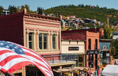
It's likely that when people think of Park City, they picture world-class skiing. Or, on snowy sidewalks, celebrities mingle while donning designer winter attire, hidden from the prying eyes of the media and the public. Given that it hosted the Winter Olympics in 2002 and is still the yearly location of Sundance, the biggest independent film festival in the country, it has a well-earned reputation. But this picture-perfect mountain town is home to much more activity that is not widely known. To begin with, Park City is a worthwhile trip in any season. Perched at an elevation of 7,000 feet amidst the undulating peaks of the Wasatch Range, it offers unparalleled opportunities for springtime hiking, summertime mountain biking, and autumn foliage viewing in the American West. Yes, this place's shoulder season is arguably its best-kept secret. Whatever time of day you arrive, though, you'll find a friendly and hospitable community that's far more diverse than its 10,000 or so residents would indicate. Downtown offers a wide variety of dining experiences, from sophisticated Michelin-starred omakase to rustic, farm-raised cuisine. The only ski-in restaurant in the world serves drinks. Alternatively, just relax in front of a fire in the lobby of a five-star luxury hotel and take in the breathtaking scenery. The closest ocean is more than a thousand miles away from this specific area of Utah. However, Park City is entirely your oyster. Additionally, access to this region of the world is now simpler than ever, thanks to the completion of enormous new additions to the nearby Salt Lake City International Airport. Here are some of the best things to do in Park City Utah. Things To Do in Park City Utah If you are curious about Park City, we have a list of details about all the things to do in Park City Utah that you cannot miss. Check them out and add them to your list when packing for the trip. Picnic Fun Maggie Alvarez is a Park City native and co-founder of Tupelo, one of the best farm-to-table dining concepts. As such, she has extensive experience finding delicious food. She wants to enjoy it outside as well, though. She enjoys taking her meal outside to enjoy the perfect mountain picnic on particularly lovely days. Additionally, there are many locations throughout the city where she can get the kind of quick lunch she needs for her job. Reputable mixologist Xania V. Woodman creates a wide range of inventive drinks at two different locations in the city: Sip & Stir and Handle. She enjoys using the torch at Red Flower Studios when she isn't working behind the bar. Winter Sports In many resorts across the nation, skiing is still an intimidating experience for individuals with disabilities. Fortunately, the National Ability Center (NAC) in Park City proves to be an exception to that rule. This nonprofit organization offers outdoor adventures and adaptive recreation to people with disabilities. It recently opened a brand-new, cutting-edge facility with a focus on inclusive winter sport access for guests with developmental, physical, and cognitive disabilities. Dine in a Yurt Have you ever desired to savor chef-driven cuisine at 10,000 feet (about the height of Mount St. Helens) above sea level in an elegant tent? The Viking Yurt provides you and your loved ones with a once-in-a-lifetime experience. The adventure starts on time at 5:45 p.m. with a 25-minute sleigh ride to Park City's highest point. As you settle in for a 3.5-hour dining experience, you are greeted with a glogg mug upon entering the yurt. Dinners must be booked in advance and start at $280 per person, tax and gratuity included. Shots at the World’s Longest Shot Ski High West offers something a little stronger if that's what you're craving. Opening along Main Street in 2007, the massive saloon boasted its own stillhouse and a distinct Old West feel. The brand relocated the majority of its production to a distillery up the road in Wanship, which is currently accessible for public tours, as its whiskey gained popularity across the nation. But there's still a lively restaurant and bar at this original location. It holds the World's Longest Shot Ski event every October. In an attempt to break the previous record, the bar served 1,340 people a group shot of spirit by arranging 528 skis end to end. Haunted History Stories If you're looking for a different kind of spirit, Park City Ghost Tours departs every night at 7 p.m. in the winter and 8 p.m. in the summer. Park City apparently takes its history seriously, as the mining camp as well as a boomtown that almost became a ghost town. The Park City Museum offers pre-planned hikes to historic locations, lectures, and local cemetery tours. It also has a top-notch Main Street exhibition that requires several visits to fully appreciate. Main Street Escapade Escape Room Park City, situated along the lower portion of Main Street, provides four unique experiences, one of which is a Mine Trap with a distinctly Western vibe. They start at $39 per person and can be reserved for up to ten players. Families will have a wonderful afternoon out. This is one of the cooler things to do in Park City Utah. Local Vino Sommelier-led wine tastings are available at the bar and lounge called Old Town Cellars. You can take pleasure in a custom assortment of pours made to your exacting requirements. Alternatively, you can accept the dealer's selection of products. It may contain wines that are skillfully blended in this very town. Whatever goes into your glass, you'll have a deeper understanding of the craft of oenology after reading this. Bakeries To Check Out Although Slovakia and Utah may not seem like the most obvious geographic partners, one adventurous expat has made the connection delicious. During the two-hour hands-on cooking class, "Bake with Lenka," guests arrive at the home of the namesake chef and learn the art of perfecting the Eastern European pastry. Reservations are accepted year-round at a rate of $115 per person. Luxurious Hotels Park City offers several choices when it comes to five-star lodging. For those who wish to stay as close to the mountain as possible, the St. Regis, the Montage, and the Pendry are all great choices. They all have heated pools, a variety of dining options, and extensive spa services. It's not unusual to get into any of these properties for about $350 per night during shoulder season. You can anticipate those rates to double come ski season. Scenic Drives Enjoying the sights and the clean mountain air of Park City can be achieved by biking. For those who are unfamiliar with the ups and downs of alpine cycling, it can be difficult terrain, particularly at high altitudes. An enjoyable and reasonably priced workaround is e-bikes. Renting yours from Pedego will cost you $85 for a half-day. Get a good workout without becoming too intoxicated. Consider making a quick trip up the Guardsman Pass Scenic Backway if you're arriving in the summer or early fall. You'll see a ton of views along the road, even though it requires driving up winding pavement for just under seven miles. All around you will be aspens, evergreens, and expansive fields dotted with wildflowers. And as you reach the 9,717-foot crest of the Wasatch Range, those views only get bigger. Alpine Coasters In all of Utah, the Park City Mountain Coaster is the longest of its kind. When you visit outside of the winter, you can reach up to 30 miles per hour as you zoom down the track's mile length. Although each ride at the top costs $30, the views are incomparable. If you like coasting, this is one of the best things to do in Park City Utah. Art and Culture For a small town of its size, Park City has a surprisingly vibrant arts scene. Over 20 galleries, featuring everything from black-and-white nature photos to bronze sculptures, line the streets. The last Friday of every month is when the Park City Gallery Association hosts its three-hour gallery stroll, when each venue's unique aesthetic is on full display. The public is welcome to attend for free. For art lovers this should be one of the best things to do in Park City Utah. Ski Deer Valley Resort In addition to providing the most opulent amenities and top-notch customer service, Deer Valley is renowned for its excellent skiing. Only skiers are permitted on the mountain; snowboarders are not permitted. Additionally, the resort only allows 7,500 skiers per day, so even during the busiest holiday seasons, the hill is never overcrowded, and you can always count on getting the most vertical. With terrain spanning four mountains, there is something for every skill level of skier. The resort caters to novice and intermediate skiers, but that doesn't mean the terrain isn't difficult. Skiers with more experience should visit Lady Morgan Mountain, as it offers excellent powder stashes and untracked glade runs. There are 6,570 feet at base elevation. Ski Park City Mountain Resort Park City Mountain Resort is a vast ski area featuring an almost infinite variety of runs. Before you ever run out of places to ski, your energy will run out. The resort features more than 330 runs, is distributed across 17 peaks, and tops out at 10,026 feet. With a good assortment of intermediate and beginner runs, the resort caters to families. In addition, while there are soft greens and expansive blue groomers, there are also black diamonds that will make your pulse race. Park City Mountain and Canyons Ski Resort combined to become one resort, but there are still two primary base areas. The largest parking area is found in the first area, which is just outside of town. The second area is in town and is mainly for guests staying at neighboring hotels. On busy days, arrive early if you want a spot because parking is extremely limited here. Vail Resorts owns Park City Mountain Resort, which is included in the Epic Pass network. In the summer, you can enjoy hiking, mountain biking, riding the mountain coaster, taking a gondola ride to take in the scenery, and other entertainment options like the summer concert series. Sundance Film Festival Every year, during the final ten days of January, Park City hosts the renowned Sundance Film Festival. This is your opportunity to see famous people. During the festival, the town is lively and bustling, making it a great place to be. Along with other locations around town, the renowned Egyptian Theater screens movies. While lodging can be expensive and hard to come by during the festival, keep in mind that Salt Lake City is only 45 minutes away, and free shuttle buses are provided by the festival from the various parking lots. In actuality, the Sundance Film Festival is a fantastic time to ski at Park City Resort and Deer Valley Resort. It tends to discourage people from going skiing during the festival because of the thought of crowds and parking in town. There will probably be excellent snow and a few lines. It's possible to spot a celebrity zipping down the hills or riding the chairlift next to you. For most people, this is one of the most exciting things to do in Park City Utah. Park City Museum Constructed in 1884, the original Park City Hall now houses the Territorial Jail and Museum. Although it may not appear large from the outside, the museum is home to a sizable collection and is spread across multiple floors totaling 12,000 square feet (about twice the area of a basketball court). Numerous interactive exhibits about Park City and the surrounding area's history are available at the museum. Exhibits include a mining exhibit where you can try riding in an old elevator and set off an explosion. Additional activities that are ideal for family outings include a visit to the Smith and Brim grocery store after a descent into the original, dank, and dark territorial jail. A synopsis of the history of downhill skiing is also provided. Egyptian Theatre Show Arts enthusiasts should visit the renowned Egyptian Theatre to see a play, comedy act, musical, or film. Additionally, the Sundance Film Festival's initial screenings took place in this theater. The theater has been restored to its former splendor after being around for more than a century. It is easy to find on Main Street. Just look for the neon-lit marquee and the bright red doors below. Throughout the year, performances happen. If you are into old stuff, this will be one of the best things to do in Park City Utah. Wrapping Up Park City offers free usage of its city buses. The buses travel all the way to lower Deer Valley properties, and taking the bus is frequently more convenient than trying to find Park City public parking. The two main ski resorts are also accessible by bus. The historic street is traversed by the Main Street trolley. Most of the stores, galleries, and restaurants are located along the trolley's route. The trolley operates between 10 and 11 p.m. In the city, ridesharing services like Uber and Lyft are widely available. There shouldn't be a long wait for these services because Park City is a popular place to get them. If you have thoughts to share or questions to ask about things to do in Park City Utah, please leave a comment below. We would love to hear from you! Read Also: The 4 Top Reasons You Should Visit Les Deux Alpes During Your Ski Break From Museums To Parks: The Top Attractions In St George Utah Ski Retreats And City Suites: Salt Lake City’s Hotel Gems