Related
What Are The Best National Parks In Arkansas? Know Why You Will Love Them
BY Sibashree Sep 1, 2021
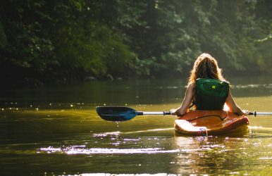
Especially, the best national parks in Arkansas, along with national museums and trails, are a must-visit to learn about the American Civil War history. But do you know that there is only one national park in Arkansas? The National Park Service only recognizes the Hot Springs National Park. Along with that, you can also explore the National Memorial, Arkansas Post, National River, Buffalo, the National Historic Site, Fort Smith, etc. For the campers and the hikers, these natural parks, monuments, and sites in Arkansas are like gems. Every hiking trail has a rich history along with a mesmerizing beauty. 7 Best National Parks In Arkansas Arkansas is home to the birthplace of the 42nd President of the United States, Bill Clinton. Also, it is known as the “Natural State.” Furthermore, the state has seen major economic success in the tourism sector. According to a report from Arkansas Money & Politics, in 2024, the tourism spending (business and leisure) was $10.3 billion, and it was a 4% increase from 2023. Now these national sites, monuments, and national parks of Arkansas are the pillars of such a tourism boom. Also, I had a wonderful time at these natural wonders. So, here, I will share some important details and my experience at these places. 1. Buffalo, The National River, Best For Canoeing, Kayaking, And Stargazing Quick Facts Established: 1st March, 1972 Flowing Distance: 135 Miles through the Ozarks Entry: Free Camping Charges: $0-$50 As I cruised through the Ozark Mountains and saw the massive limestone bluffs, Buffalo, the first national river of America, gifted me some goosebump moments. It is also one of the undammed rivers in America. As the Sun went down, I along with my co-travelers and I enjoyed our campfire on the Buffalo River banks. Furthermore, the Buffalo National River bank was designated as an International Dark Sky Park (IDSP) in 2019. You can even take part in various night sky programs in the river. Moreover, the National Park Service has made some changes to the restrooms and lighting facilities around the Buffalo River to keep the light pollution and interference minimal for dark sky observation. 2. Fort Smith National Historic Site: Best For An American Civil War History Tour Entry: Free Hours: 9 AM to 5 PM Contact Number: Voice Phone Number, (479) 783-3961 Once you visit the Fort Smith Historic Site, 80 years of history will be alive in front of your eyes. It awaits you to tell the story from 25th December 1817, the day it was established, to 1896, the jurisdiction of Judge Isaac C. Parker over Indian Territory. In the middle of Oklahoma and Arkansas, there are many historic buildings from the Civil War era, in the Fort Smith National Historic Site. Also, can you believe that 86 got the verdict of execution at Fort Smith between 1873 and 1896 in the courtroom of Isaac C. Parker? The gallows are also still there. Does not seem surprising again, thanks to the jurisdiction of Judge Isaac C. Parker, who believed and said, “Permit no innocent man to be punished, but let no guilty man escape." 3. Hot Springs: The National Park In Arkansas With Ancient Thermal Springs Entry Fee: Free Hours Open: Visitor Center, 9 AM to 5 PM, and Hiking 24/7 Hot Springs, the national park of Arkansas, has an interesting geology, and the ancient thermal springs are the most fascinating feature of this national park. Furthermore, it has historic bathhouses where you can heal and relax with the ultimate spa experience. Choose between the Lamar Bathhouse, Ozark Bathhouse, Hale Bathhouse, Superior Bathhouse, and many such names. Also, remember that the bathhouse area, constructed during the period of 1892 and 1923, was designated as a National Historic Landmark District in 1987 along with the Grand Promenade. Furthermore, along with exploring the hot springs and bath houses, you can even camp at the Gulpha Gorge Campground. The camping fee is $34 per night. However, the most rewarding experience here is hiking through Hot Springs and North Mountain Trails, Sunset Trail, and West Mountain Trails. 4. Little Rock Central High School: National Historic Site I missed visiting the Little Rock Central High School. In 1957, this school was the epicenter of the enforcement of the African American Civil Rights. The school followed the Brown v. Board of Education. Moreover, the struggle of the Little Rock Central High School ensured that everyone around the world got opportunities for education. 5. Arkansas Post: National War Memorial Henri de Tonti established the Poste de Arkansea in 1686. Located at the Quapaw village of Osotouy, it became known as “The Post.” There was a long struggle between Spain, France, and England for dominion over the Mississippi Valley. The Post eventually became the first semi-permanent settlement of the French in the Lower Mississippi Valley. Moreover, The Post is witness to the only Revolutionary War in Arkansas, in which the British partisans logged head with Spanish soldiers. It took place in 1783 and was also known as the Colbert Raid. Again, in 1803, thanks to the Louisiana Purchase, the Post became a part of the United States. Moreover, by 1819, it was the first city to become the capital of the Arkansas Territory, and it was the largest regional city. During the Civil War, Fort Hindman was built here to take control over the confluence of White and Arkansas Rivers. However, it was destroyed in 1863. 6. President William Jefferson Clinton Birthplace This place is the perfect definition of an American leader born in the woods, who makes some revolutionary movements. President William Jefferson Clinton was born in the Town of Hope in the Arkansas ranges. The president spent his first four years here. The property is still in good condition. Take a walk on the property. Then take a tour of the town of Hope. And feel the historical vibes of the place. 7. Trail Of Tears The historical value of the trails is pretty touching, and is remembered by the Native Indian tribes and the Cherokee people. The Trail of tears is a historical trail that is 5,043 miles long. The track stretches from the southern Appalachian mountains to the west side. This single historical trail crosses over nine USA states. The heart-touching facts are attached to this trial. In 1830, seventeen Cherokee groups were removed from their homelands. And the painful consequences determined the fate of these people. For the remembrance of the sacrifice of the people, this historical path is called the Trail of Tears. Wrapping It Up: The best national parks in Arkansas, along with other national sites, are good travel destinations for people of all ages. If you are looking for a good travel option that has historical value. This is the best choice. For adventure-loving travelers, this is the best choice to spend the entire day on the side of the Buffalo River. You can visit the nearest places from the river banks, and all the hiking trails lead towards a town. So most often there is less chance of getting lost. But morning and daytime are the most suitable times to explore the place. So what is your next travel plan? Do not forget to share your experience with us in the comment section. Read Also: Living Your Solo Travel Dreams: 8+ Best Places To Travel Solo Female In US Unique Things To Do In Tulsa: Into The Land Of Art Deco Architecture Be Soothed And Meet History At Hot Springs National Park