Surviving The Sizzle: Things To Keep In Mind While Traveling To Heat Wave Zones!

Sep 7, 2023

Last Updated on: Sep 1, 2025

Travel Blog

Summers are warm. However, Scorching heat in certain places has highlighted them as heat wave zones. With heat wave temperatures across many areas worldwide, we are reminded that climate change is a global phenomenon.

A significant health risk, heat wave zones make it difficult for people to travel, stay, enjoy or perform professional liabilities. I will identify certain important factors that influence travel plans, health risks and ways in which you can be safe from heat waves.

The conditions that are being observed across the world in some beautiful vacation-worthy locations are serious! They can impact your health and lifestyle, so read the article to learn about the dangerous conditions that will likely affect your travel plans.

Things To Keep In Mind While Traveling To Heat Wave Zones!

Things To Keep In Mind While Traveling To Heat Wave Zones

Across the world, many places are currently heating up! Several tourist destinations and other places in Asia, Europe and the United States have heat wave temperatures. Officials in countries like France and Italy in Europe have issued health warnings.

I am not saying it is highly risky, but the probability of the situation becoming risky is high! If you are visiting one of the heat wave zones, you may not be able to stick to your original plan, be it for vacation or professional liabilities.

Let’s explore further the precautions you might take to be safe when you visit or have to visit a heat wave zone!

What Are Heat Waves?

What Are Heat Waves?

The increasing global temperature worldwide has led to people experiencing some of the hottest days! According to the weather reports, the heat intensifying in several countries worldwide has led to people fainting, sunburns and health concerns such as sunstroke.

It is identified as a heat wave, especially when the temperature from June 2023 has been recorded as the warmest in the global records. The increasing heat wave temperature has succinctly impacted water supplies, agriculture, ecosystems, energy, human health and economies.

One of the major reasons for heat waves has been greenhouse gas emissions, which need to be cut off as soon as possible. Climate change is a serious threat; we must take it that way to survive and help our future generations.

What Are The Regions With Heat Wave Zones?

Regions With Heat Wave Zones

In Europe, the temperature in Rome reached 104°F in July, while in Sardinia, it was 112°F. In at least 23 cities in Italy, there have been red alerts for the weather as the heat wave is potentially becoming a threat in recent times. Tourists have been passing out, creating an awareness towards global climate change and crisis.

Now, Death Valley in Nevada, running along a section of the border of Central California, is identified as the “hottest place on earth“! The National Weather Service reported that the temperature reached 128°F in July 2023, a clear cause for concern. People living in Los Angeles heat wave are having serious health issue concerns!

According to the weather forecast, the capital of Arizona, Phoenix, has seen a rise in temperature to 114°F while Florida and Texas are equally heating up! La Palma, located in the Canary Islands, has been riddled with wildfires recently, leading to the evacuation of 4,000 people from their homes.

The popular tourist destination, the Acropolis in Athens, was shut down at the beginning of July this year during midday! It is peak time for tourist visits, but because the authorities informed us the temperature could rise to 111.2°F within a week, it was closed!

In China, the recorded temperature in northwestern Xinjiang province was 126°F. Places worldwide have been hampered by the heat wave temperatures, impacting people’s lifestyles, tourism and the country’s economy.

Is It Safe To Travel To Heat Wave Zones?

Is It Safe To Travel To Heat Wave Zones?

As travelers, you should check the upcoming weather and climate of the location that you are visiting! If you visit one of the places I have stated regarding increasing temperature, you must keep a tab on the everyday temperature.

Your sightseeing might go differently than planned if a situation occurs when one of the monuments or places you will be visiting is shutdown due to increasing temperature. If you suffer from chronic health conditions, you should not go out, especially in the scorching heat!

If you are visiting from professional liability, you must carry out certain steps to cope with the heat. Remember that the temperature starts building from 11 a.m.; hence, try to enter a building or where your work is within that time frame.

Read along further to learn about your steps to stay safe!

What Are The Things To Do If You Travel To Heat Wave Zones?

Things To Do If You Travel To Heat Wave Zones

In the evening, the temperature will come down. Hence, it would be best to keep yourself cool in the daytime. The first thing is to wash your face and arms, including your armpits and wrists, so your body temperature can feel a bit of semblance.

You can repeat the action as much as possible the whole day! If you are visiting Europe, you’ve got it easy! There are fountains in Europe. Apart from that, you need to take cool showers and air-dry yourself! It will keep the temperature of your body down.

In some countries, such as Italy, residents are asked to stay in an air-conditioned environment for at least 3 hours a day. Try to find a cool restaurant, gallery or museum if you are visiting one of these countries to stay in air conditioning for some time.

Try to wear clothing that is made of cool fabric, such as cotton! It is even better if the material is light and loose from your clothing. Try to use sunscreen as much as possible. Recently, people have been using manual and electric handheld fans to keep the face and body cool as much as possible.

Another important thing that you must do is use heat wave sunglasses when outside!

Drink more beverages and filled food, such as fruits, salads, and veggies! Also, ensure that you must have insurance covering all your medical expenses before traveling.

What Are The Health Risks?

What Are The Health Risks?

Heatwave zones have several health risks, such as heatstroke or sunstroke! In this condition, your body cannot maintain a safe temperature, especially when exposed to hot weather. The body temperature must not exceed 103 Fahrenheit, but in sunstroke, it does.

There is also a chance of getting pale skin, muscle cramps, sweating, and exhaustion. Currently, the US heat wave is one of the serious concerns for business travelers!

You might get red and blotchy skin if you stay in the sun for too long! You have to take fluid regularly.

Chances of dizziness, headaches, and sweating when visiting heat wave zones are high!

Finishing Up…

Overall, climate change has led to health risks along with issues where people cannot avoid these situations. With increasing temperatures in certain places across the world, people, children, and senior citizens cannot cope with the increasing temperature.

People with chronic health conditions such as allergies to skin, asthma, upset stomachs, and headaches are facing more issues, especially when traveling to heatwave zones. I suggest following the tips and consulting a doctor if the situation worsens.

Let us know your thoughts about this situation and how to be safe in heat wave temperatures!

Read Also:

Share on Social Media

Sagnika Sinha is a content writer who is passionate about writing travel vlogs, entertainment and celebrity articles and literature-based pieces. With a 4 years experience in teaching, she loves reading books. A procrastinator by nature, she loves travelling, listening to music, planting and gardening.

Leave a Reply

Your email address will not be published. Required fields are marked *

title-img Related

READ MORE

How About Exploring The Hiking Trails in Channel Islands National Park?

BY  Sibashree Aug 20, 2024

It’s hard to imagine that a watery wonder and a versatile geological place exist so close to the Californian Mainland. Yes, we are talking about the Channel Islands National Park.  Rich in diverse flora, fauna, and wildlife, this national park, consisting of five islands, is a hiker’s favorite. The hiking trails on each island are different. For example, the trails in Anacapa are flatter, and they get steeper as you visit Santa Rosa or Santa Cruz.  Also, as a critical marine sanctuary, this national park offers an amazing experience for people interested in aquatic pursuits. Boating and scuba diving here are activities that an adventurous soul will surely look upto.  Are you ready to pack your bags and hit the trails? Let us join you. Channel Islands Hikes That You Just Cannot Miss  Hiking trails in the five islands of this national park vary in their difficulty parameters. The trails in Anacapa, Santa Rosa, San Miguel, Santa Cruz, and Santa Barbara are easy (Cavern Point Loop), moderate (Potato Harbor), and hard (Montañon Ridge Loop).  As a hiker, you have to be sure of your physical and mental endurance before you start exploring specific trails. Further, you will encounter many challenges as you explore the hiking trails.  Common perils here include poisonous oaks, scorpions, ticks, wildfire risks, reptiles, and Hantavirus spread by deer mice. To deal with these hazards, you must make the most of the buddy system and, most importantly, be respectful to the wildlife.  However, the pain you have to undergo throughout the journey is worth the dramatic experience the trails offer. It’s time to know about them.  Anacapa Island Hiking  Anacapa Island got its current name from its original Chumash Native American Indian name, Anypakh. This island is made of East, Middle, and West Anacapa islets, and surprisingly, none of these are connected to each other.  Before I introduce you to some of the most amazing trekking trails in Anacapa, let me share some highlights about the island. Anacapa Island: Things To KnowAnacapa is known for its diverse vegetation, wildlife, culture, and history.Coreopsis and sunflowers come to life after the winter rain, and you can see them from the California Mainland.Anacapa is the largest breeding colony of western gulls in the world.It is also the largest breeding colony of the California brown pelicans, which are endangered species.Chumash Indian people used to camp here thousands of years ago. Inspiration Point Hike (Easy) Just a 1.5-mile hiking trail, Inspiration Point offers the most amazing view of the island. Enjoy the sheer contrast created by vibrant wildflowers and the tranquil blue water.  Pinniped Point Hike (Easy) Pinniped Point hike, which is a 4-mile distance, is known for its sea lion rookery and lighthouse.  Cathedral Cove Hike (Easy) The 6-mile hiking trail is the best place to see the most amazing rock formations. Here, you will also find beautiful kelp forests, sea lions, sea caves, and birds.  San Miguel Hiking  Hiking in San Miguel is a little tricky as you cannot take the off-trail roads. Further, hiking is only limited to certain spots, as its unique geological features, wildlife, and plants need preservation.  Caliche Forest Hike (Hard)  Despite its difficulty level, Caliche Forest is the most exciting trail to hike in San Miguel. This landscape of five miles has naturally calcified prehistoric vegetation. So, the entire area has the most surreal “fossilized” appearance. A visit to this trail is like a time travel, and the feeling is, at times, eerie.  Cuyler Harbor Beach Hike (Easy) Enjoy the pristine beauty of the 2 miles of white sand stretch and observe the adorable seals. Take a walk along the beach to find the sand running into the rocks.  Cabrillo Monument Hike (Hard)  The distance of this trail is 2 miles. However, the steep climb makes the hiking experience very strenuous. You will visit the monument of Juan Rodriguez Cabrillo, the first European to explore this island.   Santa Cruz Island Hiking  Santa Cruz, or the La Isla de Santa Cruz, is the land of the Sacred Cross. Known as Mini California, this island has endless bounties to offer. From the Transverse Mountain ranges to the deep valleys, canyons, and beaches! You will meet the most diverse geological picture here. Here, I will talk about some of its most prominent hiking trails. However, before that, let’s share some interesting facts about the island. Things To Know About Santa Cruz IslandSize: 96 Square Miles (The Largest Of The 5 Channel Islands)Plant Species: 600Plant Communities: 10Landbird Species: 140Land Mammal Species: 11Cultural History: More than “10,000 years of American Indian habitation, 150 years of European exploration” Cavern Point Loop Hike (Easy) Cavern Point Loop is a popular destination for hiking, kayaking, and seasonal whale watching. As you trek through the 2 miles route, you will get to see the most magnificent coastal vistas.  Potato Harbor Hike (Moderate)  The harbor gets its name from its unique oval or potato shape. The cliffs here are steep and dangerous. The bright white sedimentary rocks (diatomaceous earth) here are formed by diatoms or single-cell sea plants made of silicon dioxide.  Diatomaceous earth has wide applications in filtering water.  View this post on Instagram A post shared by Channel Islands National Park (@channelislandsnps) The Giant Kelp Forest is another attraction in Potato Harbor. Kelp is a nutrient-rich and fast-growing algae that helps build a rich marine ecosystem. The California sea lions here will make your visit to the island most delightful with their playful nature.  Montañon Ridge Loop (Hard) Montañon Ridge, with Montañon Peak and High Mount, is the highest ridge on the eastern side of the island. This trekking trail is only for experienced hikers.  The total distance of the hiking trail is 10 miles.  Santa Barbara Hiking  View this post on Instagram A post shared by Channel Islands National Park (@channelislandsnps) Santa Barbara is an island for endless outdoor pursuits like hiking, camping, fishing, and watching wildlife.  Further, Santa Barbara is the island to be if you want to explore the local vegetation. If you visit the island in spring and winter, you will meet the most colorful wildflowers here. Also, delightful flowers like poppies and verbenas are in full bloom in the summer. Do you want to hike on this island? Here are some trails for you.  Lizard’s Mouth Hiking Trail (Moderate) You have to take just a quarter-mile walk off West Camino to find this hiking spot. It’s also a favorite Santa Barbara destination for picnics.  The place gets its name from the rock formation resembling a lizard’s open mouth. This place is picturesque and perfect for photoshoots.  La Cumbre Peak (Diificult)  With the highest elevation of 1215 m, the La Cumbre Peak (the highest in Santa Barbar) hike is full of challenges. However, this trekking trail is full of highlights like the Cathedral and Arlington Peaks, the coastline to the sea, etc.  San Roque Creek (Easy) The San Roque Creek trail is located in the 25-acre recreation area in the park. The area is called Stevens Park. With just an elevation gain of just 93 m, it is an easy trail to explore, and you can have a great time walking with your dogs here.  Santa Rosa Hiking  The hiking trails in Santa Rosa are a combination of flat and steep terrains. The trails to the Water Canyon Beach are flatter. At the same time, roads to the Black Mountain are strenuous.  Water Canyon Campground Hike (Easy) This 3-mile hiking trail is one of the easiest routes in Santa Rosa or all over the Channel Islands. Enjoy a gala picnic with your group here.  Water Canyon Hike (Moderate To Strenuous) The perennial canyon and the local vegetation make the water canyon hike the most amazing experience. If you want, you can also follow the stream bed and get wet.  Black Mountain Hike (Hard) With a distance of 8 miles, this trail offers the most amazing views of the mainland and San Miguel, Santa Cruz, and Santa Rosa islands.  Did You Know? By 1928, many fossils of pygmy mammoths were found in the Channel Islands. Further, almost a complete skeleton of an adult pygmy mammoth was excavated on Santa Rosa Island in 1994. These mammoths were very similar to the Californian mainland mammoths. However, they evolved and got smaller in size to accommodate on the Channel Island. Worldwide, these mammoths are known as Channel Islands Pygmy Mammoths.  Final Words  Channel Islands National Park had 328,746 visitors in 2023 (Source). Despite being close to the California mainland, these islands offer tranquility, and with many places to visit and activities to do on the five islands, you will surely be spoilt by the choices at this national park.  On all the islands, you can trek, fish, camp, and take part in many water sports. However, two of the most coveted activities in these parks are hiking and exploring marine life. The variety you find here in whales and other marine mammals can be a close match to the vibrant marine ecosystem of Wrangell-St. Elias National Park.  In this guide, I have highlighted trekking through the trails in this national park. Do you want to know more about its wildlife and marine ecosystem? Share your thoughts in the comment below.  Channel Islands National Park FAQs  Which Island Is The Best To Hike In Channel Islands National Park? Anacapa and Santa Cruz islands are great for hiking in the Channel Islands. However, if I am to share my opinion, Anacapa will be my silent favorite.  The trekking trails here are way easier in Anacaopa than in Santa Cruz. So, irrespective of your expertise level, you will be able to hike the entire island in a day.  Also, as the trekking journey here is less arduous, you will be able to enjoy the surrounding scenic beauty even more. You will meet the most adorable sea birds, sea lions, and seals. Also, if you are lucky enough to be in these mountains during spring or late winter, you will find the mountains replete with colorful wildflowers. Inspiration Point, Cathedral Cove, and Pinniped Point are some of the highlights of hiking expeditions in the Anacapa Islands.  What Is Special About Channel Islands National Park?  Channel Islands National Park is special because it is a paradise for trekkers, nautical surfers, and wildlife explorers.  Its San Miguel, Santa Rosa, Anacapa, Santa Barbara, and the largest, Santa Cruz islands have many hiking trails with Transverse Ranges.  Further, half of the national park is under the ocean, and you will find six nautical miles of water around it. So, it is a critical marine sanctuary and a great place for scuba diving, boating, and other aquatic pursuits.  In addition, its wildlife is mesmerizing, with the presence of animals like island foxes, spotted skunks, salamanders, whales, California sea lions, sea otters, dolphins, giant black seabass, and more.  Which Island Is The Largest In Channel Islands National Park? The largest island in the Channel Islands National Park is Santa Cruz, which is also known as the epitome of California. Its size is 96 square miles.  Its geology is versatile, with Transverse Ranges, fault systems, springs, streams, and canyons. You will also come across sea caves, beaches, and coastline cliffs. Among the sea caves, the Painted Cave is the most prominent one with lichens, algae, and colorful rocks. Also read Why Include Whale Watching In Your LA Itinerary. Traveling On A Budget: Tips For Affordable Adventures. Be Soothed And Meet History At Hot Springs National Park.

READ MORE Rio de Janeiro Travel Guide

Rio de Janeiro Travel Guide: What Your Brazilian Real Gets You

BY  Sibashree Sep 20, 2025

Rio de Janeiro sweeps you up the moment you arrive. Golden beaches stretch for miles, samba rhythms spill from bars in Lapa, and cable cars glide up Sugarloaf Mountain for some of the best views on Earth.  Life here is colorful and fast-moving, and part of slipping into that rhythm is knowing how far your Brazilian real will take you - from a chair on Ipanema beach to a plate of feijoada in a neighborhood café. Before we go on, here is a quick Rio de Janeiro travel guide. Just a quick note: exchange rates and prices don’t stay still. At the moment, 1 US dollar equals about 5.4 Brazilian reais, but it’s best to check the latest rates and costs before you travel. Rio de Janeiro Travel Guide: What To Expect? Rio de Janeiro is one of the best cities you can explore. It is one of those few places that has a care-free energy and will make you feel alive. The beaches, food, and major attractions will draw you to it without even trying too hard. Here is a simple Rio de Janeiro travel guide. Beaches - Rio’s Living Rooms The beaches of Copacabana and Ipanema are more than postcards - they’re part of daily life. Locals jog along the promenade in the morning, families gather for a swim, and groups of friends set up for impromptu games of beach volleyball or footvolley. Tourists blend right in, renting chairs and umbrellas from vendors for around R$10-15 per piece. Snacks come to you. Vendors walk the sand offering everything from ice-cold coconuts (R$8-10) to grilled queijo coalho (cheese skewers) for about R$12. You can even try a caipirinha mixed fresh on the spot, usually for R$15-20. These are usually cash-only transactions, and the small notes feel like part of the ritual - bargaining isn’t common, but handing over a few reais feels easy and authentic. Spend an afternoon at Arpoador, the rocky point between Copacabana and Ipanema, and you’ll see why locals gather here at sunset. It doesn’t cost more than a bus ride (R$5) to get there, and yet it’s one of the richest experiences you’ll take home. Food: From Street Bites to Sit-Down Meals Rio has a huge range of food. Starting from some humble bakeries to some fancy rooftop restaurants, Rio has it all. Start with breakfast like a local: pão de queijo (cheese bread) and strong coffee, often no more than R$10-15.  Step into a juice bar and you’ll find tropical flavors like passion fruit, guava, or the ever-popular açaí bowl, usually under R$20 for a generous portion. At lunchtime, the prato feito is king. This “set plate” of rice, beans, salad, and a protein such as beef, chicken, or fish costs R$25-35 and will keep you full all day.  You will get various self-service buffets that charge by weight. You will get roasted meats, vegetables, and farofa, and you will have to pay around R$30-40. For dinner, you can choose what you prefer. You can try something casual or something fancy. If you prefer a mid-range seafood meal along with drinks, it will cost somewhere around R$80-100 per person.  However, a proper night out in Ipanema at a fancy fine-dining spot might cost around R$200-250.  You can even visit Churrascarias, which is a Brazilian steakhouse. It is an event in itself. They have endless skewers of grilled meats, side dishes, and salad bars. You can expect to pay somewhere around R$120-180 per person. However, this does not include drinks. All these places accept cards, but it is better to keep some cash handy for bakeries and street food. Attractions: Big Names And Hidden Gems There are various major icons in Rio, and those are actually worth it. You can take the Sugarloaf Mountain cable car for around R$150, and the ride itself is a major part of the thrill. The glass walls will give you a 360-degree view of the way from above the city. You can visit Christ the Redeemer, resting on Corcovado Mountain, for R$100. The moment you stand at its feet and see the city from there, you get an amazing view. You can carry cards as both attractions accept payment in cards. However, it is better to carry some cash for small vendors, tacos, or snacks. Rio is also filled with a lot of gems that you can see for free or for a low cost.  The Selarón Steps, covered in colorful tiles from around the world, cost nothing to climb. A stroll through Santa Teresa’s narrow streets will take you past murals, studios, and cafés where you can pause for a R$12 espresso. At night, head to Lapa to experience samba at its source. Entry to some clubs is around R$30-50, and drinks inside range from R$15-25. Smaller bars may only accept cash, especially if you’re outside the main tourist drag. Getting Around Rio is quite a big city, but it is not difficult once you understand the system. You can take the metro, it's quite safe and clean, and a single ride costs around R$5.  Moreover, if you have a rechargeable RioCard, it will save you a lot of time and work. You will be able to use it for different types of transport, including trains and buses.  You can take a bus, which goes almost to the city, and the fare is quite similar to the metro. Here, you can get taxis for around R$6, and cross-town trips generally range around R$40-60. Also, Uber and other apps like these are popular, and often offer rides at a cheaper rate than a taxi. If you want, you can pay in-app with the card, and that way, you will not have to use cash for payment.  For day-trips outside the city, you will get intercity buses. This will help you explore the outskirts within a budget. If you are planning to visit the historic mountain town, Petropolis, you can explore it for around R$40-50. Moreover, if you are planning to take a longer ride to Búzios, the beach town, you will be able to visit it for around R$70-80. You can get the bus tickets online or from the bus station as well.  How Much To Budget You need to prepare a budget for a trip. However, the budget depends on the kind of trip you want to have. Budget travel: It will cost you around R$200-250 for a day, including hostels, street food, public transport, and free attractions. Mid-range: It will cost you around R$600. You will get comfortable hotels, visit some of the major landmarks, and have some casual as well as sit-down meals. High comfort: This will cost you around R$1000 and above. You will get four-star hotels, fine dining, and guided tours at this range.  However, the prices in Rio rise during any carnival or New Year’s, and this also varies depending on the neighborhood.  Ipanema and Copacabana are some of the premium places that tourists visit, but there are some block islands that will offer the same charm but at a lower price range. Spend Smart In Rio Start your trip with at least a little Brazilian real in your wallet. It will cover your first taxi or ride-share, snacks, or that first fresh coconut without delay. From there, cards will carry most of your expenses, but having R$100-200 in cash each day is wise for small payments. Stick to ATMs inside banks or malls when you need to withdraw. They’re safer and usually give fair rates. Avoid exchanging money at the airport - the rates are often poor, and the fees stack up quickly. Think about how you balance cash and cards. Use your card for hotels, restaurants, and tours, and keep your reais for buses, bakeries, street snacks, and tips. It’s a system that works well in Rio and lets you move through the city without stress. Enjoy Your Journey Landing in Rio with a Rio de Janeiro travel guide and Brazilian real already in hand saves you time and makes the city easier to navigate. You’ll breeze through those first transactions - a cab, a snack, a metro ride - and step right into the energy of the city. Rio rewards travelers who embrace both the big icons and the small everyday moments. The real you spend on a chair at the beach, a cup of coffee, or a bus ride across town is more than just money - it’s your ticket into the rhythm of the city.  As mentioned before, exchange rates and prices may change, but the value of those moments never does.

READ MORE Phuket Sunset Cruises

Best Routes For Sunset Cruises Around Phuket

BY  Sibashree Nov 18, 2025

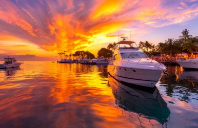
The Andaman Sea transformed into a spectacular canvas. The water started reflecting shades of violet, crimson, and amber. The experience was not just my eyes capturing some beautiful visuals. It was immersive. The tranquil setting, the chirpings of the birds going back to their nests, and the golden glow bathing everyone’s face, transported me to somewhere else. The crowded viewpoints on the beach were at a distance, and it was like the noise in my mind, which I wanted to distance myself from. This is how magical the Phuket sunset cruises can be. We seldom connect Phuket and a cruising experience there with something spiritual. However, if we allow ourselves, we can explore a different side of Phuket. In my mind, the lines of the famous Pink Floyd song were playing. “And as the windshield melts My tears evaporate Leaving only charcoal to defend. Finally, I understand the feelings of the few. Ashes and diamonds Foe and friend We were all equal in the end…” The sunset cruising was a kind of experience that made me feel one with the universe. Also, everything good and bad that happened in my life kept occurring before my eyes as a flashback. In this article, I will talk about the prime routes for the Phuket sunset cruises, how the surrounding elements define the experience, and every other detail you need to know. Prime Routes For Phuket Sunset Cruises The prime routes for Phuket sunset cruises offer diverse experiences. While the western coastline is about drama, the northern routes are surreal. Furthermore, the island-hopping circuits are more action-packed with itineraries including snorkeling and swimming. 1. Western Coastline The western coastline presents the most dramatic sunset vistas, with Promthep Cape serving as a legendary reference point. Promthep Cape, or the Laem Promthep, is on the southernmost tip of Phuket. The rocky outcrop here sets the stage, and as you climb it, you will see how the Sun creates magic on the waters of the Andaman Sea during the sunset hours. In addition, the panoramic view from the clifftop was amazing, and again, a famous quote came into my mind that when we see a problem from a distance, it looks smaller, but when we go close to it, it appears bigger and sometimes unbearable. Departing from Chalong Bay allows vessels to navigate toward this southern landmark while maintaining optimal positioning as daylight fades. The journey typically passes Rawai Beach and Nai Harn Bay, where protected waters create smooth sailing conditions ideal for photography and relaxation. 2. Northern Routes Northern routes toward Phang-Nga Bay offer a different perspective, with limestone karsts silhouetted against the glowing sky. These geological formations, such as the caves and lagoons, add depth and character to sunset compositions, particularly around Koh Panyee and the surrounding archipelago. The bay's sheltered nature ensures calm conditions even during monsoon transitions. If you want an added dose of adventure, you can take a canoe and explore the sea caves, inlet caves, and lagoons as the daylight starts getting softer and nature prepares for the sunset. 3. Island-Hopping Circuits Island-hopping circuits incorporate the following spots. Coral Island Racha Yai Khai Islands These itineraries typically allocate afternoon hours for swimming and snorkeling. Atmospheric Elements That Define The Experience As the Sun began spreading different shades of red and touched the waters of the Andaman Sea, I felt a subtle chill in the air. The midday heat was still there like the strongest perfume, the whiff of which remains on a shirt even after a wash. Within a few minutes, the transition in the weather became very prominent. The calm evening winds began to blow, infusing everyone on the deck with a sense of relaxation. I felt like that time stood still, and I quickly put on my jacket to be more comfortable in the moment. The jacket kept me cozy while I was still feeling the ocean breezes directly caressing my face and hair. Also, the color change felt like a 45-minute masterclass. At first, everything began to soften; the bright daylight took on a mellower tone, and then came the real drama, with intense saturation during the final ten minutes before dusk.  Finally, the lights were on, and the Andaman Sea looked most mysterious as the sky became dark. The blue hour, or the moments just after sunset, is dreamy in Phuket. There are aesthetic pastel tones everywhere, and the stars were becoming visible in the sky one by one. Standing on the deck of the water and with water everywhere around our cruise, there was very low light pollution. So, the stars and constellations shone the brightest. Thanks to this change of colors for an extended period, I could take some brilliant snaps. There was no rush, and I could experiment with my lenses and angles. Also, this extended timeline gave me enough time to cherish contemplative moments, and there was no rush. Companies specializing in yacht rentals in Phuket, such as DreamCharter, offer dedicated sunset cruise packages with professional crews managing navigation and timing to position guests at optimal viewing locations. Viewing Locations Open-water positioning west of the major islands maximizes unobstructed sightlines toward the setting sun. However, incorporating foreground elements such as traditional longtail boats, rocky outcrops, or palm-fringed shores adds compositional interest to photographs and enhances the overall visual narrative. Areas with minimal light pollution, particularly between islands or away from Patong's illuminated coastline, allow stars to become visible shortly after sunset. This astronomical dimension extends the experience beyond the sunset itself, creating a seamless transition into the evening. The combination of maritime mobility and natural spectacle makes sunset cruising a distinctive way to experience Phuket's coastal environment. Whether seeking romantic ambiance, photographic opportunities, or simply peaceful moments on the water, these golden-hour voyages deliver perspectives unavailable from land-based vantage points. November to April is the best season for sunset cruising in Phuket. Sunny days and clear skies make these months ideal for experiencing the beautiful transition of colors and stargazing after dark. Read Also: Three Of The Best Must-See Attractions During Your Time On The Thai Island Of Phuket 5 Must-Visit Places In Thailand: Should I Go To Phuket Or Krabi? Should You Choose A Luxury Resort In Phuket?