Are you searching for the best national parks in New Mexico? If your answer is yes, then you have reached the right place.
There are many breathtaking vistas in New Mexico. It is in the Southwest region of the United States, yet tourists generally ignore them. The state is also home to the Rocky Mountains, and the Rio Grande. It is a variety of vivid canyons, cliffs, and caves in addition to its stunning but harsh desert landscape.
If you are planning to visit the state, you need to check out some of the best national parks that are located in New Mexico. If you don’t know which one to begin with, you might just find his blog to be of help. Keep reading this article till the end to learn more…
Top 10 Must-Visit National Parks In New Mexico In 2024!
You can tour the magnificent archaeological sites that the Ancestral Puebloans left behind at several locations. It provides a fascinating look into the cultures and individuals who have influenced the state. They are protected as a component of the nation’s parks and monuments.
With so many facets and breathtaking beauty on display, New Mexico more than lives up to its moniker as the “Land of Enchantment.” And what better way to explore them than the national parks in New Mexico!
Here are the best national parks in New Mexico that you need to visit at least once in your life. If not in the year 2023!
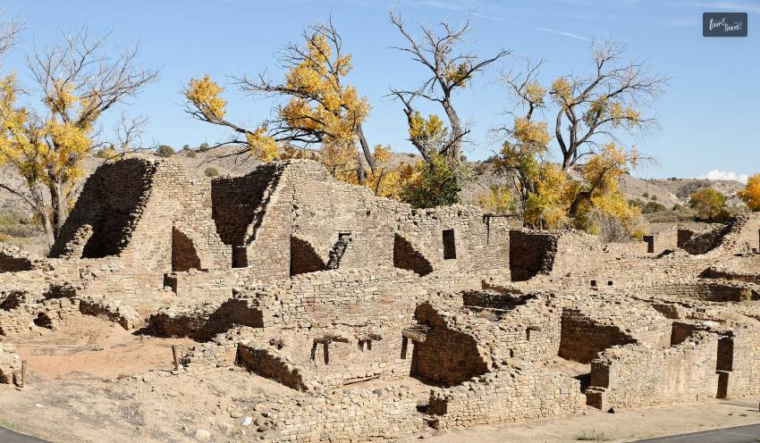
1. Aztec Ruins National Monument
The captivating Aztec Ruins National Monument, which is next to the little city of the same name, is tucked away in the state’s northwest. It has been guarding the ruins and remains of a fascinating prehistoric pueblo, thought to have been constructed about a thousand years ago, since 1923.
This magnificent archaeological monument has over 400 rooms to explore, with its Great Kiva unquestionably the standout. American settlers mistakenly credited it to the Aztecs. Visitors can enter a duplicate that has been meticulously recreated in order to see the real ruin’s glorious stonework. You can also view it as it was in its prime.
The museum at the National Monument is definitely worth visiting. Especially if you want to learn more about the history and culture of the Ancestral Puebloans. There are lots of eye-catching exhibits and artifacts there.
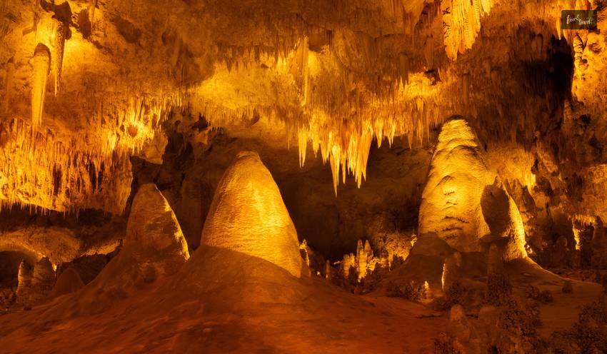
2. Carlsbad Caverns National Park
Carlsbad Caverns National Park comes in second on the list of the top national parks in New Mexico. The fascinating Carlsbad Caverns National Park is located in the southeast of the state, not far from Texas. It is a remarkable location with more than 119 caves, the greatest and most impressive of which is Carlsbad Cavern, its show cave.
Although the state of New Mexico is breathtaking from the outside, Carlsbad Caverns National Park is home to at least one subsurface natural wonder. Carlsbad is far from anything else in New Mexico. It is situated on the border with Texas, is well worth the trip.
The Big Room is a natural chamber that is 4,000 feet long, 625 feet wide, and 255 feet high. It is the third-largest cave chamber in North America and the seventh-largest in the world. Carlsbad is covered in limestone that an old coral reef deposited.
Intricate and enormous, Carlsbad is home to tens of thousands of rare cave formations. It includes stalagmites, stalactites, cave pearls, flowstones, cave crystals, and underground lakes. Visitors have the option of taking a ranger-led expedition into one of the less popular caverns. They can also explore the well-lit tunnels on their own.
The half-day Hall of the White Giant and Spider Cave trips are not for the claustrophobic. But the King’s Palace and Left Hand Cave tours are appropriate for kids and beginners. The closest established campsite is in Guadalupe National Park, which lies across the Texas state line. Camping is permitted in the park’s wilderness.
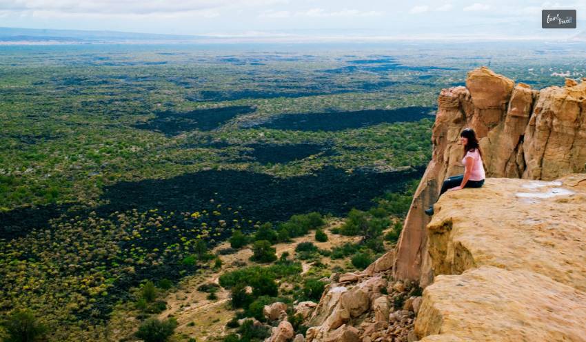
3. El Malpais National Monument
The state’s westernmost national monument, El Malpais, is where a sizable volcanic field may be found. It is situated in a remote but breathtaking area just off Interstate 40 and is full of cinder cones, lava flows, and rock formations.
Its barren, devastated, and lava-scarred areas, which are a part of the Zuni-Bandera volcanic field, seem to continue on forever; the most recent flow occurred there about 3000 years ago. There are several amazing lava tubes for visitors to explore, some of which are home to shimmering ice caverns, tucked away among the isolated and rocky remnants.
El Malpais’ immensely varied volcanic scenery provides solitary pursuits, leisure, and adventure. Unbelievable geological phenomena like lava flows, cinder cones, lava tube tunnels, and sandstone bluffs are just a few to explore. People have been adjusting to and living in this unique terrain for decades, despite what some may perceive as a barren setting.
4. El Camino Real de Tierra Adentro National Historic Trail
In all of the United States of America and Mexico, El Camino Real de Tierra Adentro is revered as a historic path for trade and cultural exchange. Trade and travel along this path influenced the settlement and growth of the larger Southwest and changed the lives of individuals and communities.
In addition to helping to break down barriers between cultures and improve the lives of those who live along El Camino Real de Tierra Adentro, the designation of this route as an international historic trail honors the connections and interactions that have existed between American Indian, Mexican, Black, Spanish, and other European cultures both historically and currently.
The aims of El Camino Real de Tierra Adentro were varied. Many of its users participated in the lengthy mission of the Spanish empire to convert American Indians to Christianity. However, the road was home to a wide variety of personalities; those traveling north included settlers, priests, and newly appointed officials; those traveling south included retiring officials, friars, traders, enslaved Indians, prisoners of war, and convicts.
The path was also a key route for trade, serving as a conduit for the exchange of products and knowledge. Each of the thirty-two waggons in a typical caravan along the road was pulled by eight mules and could hold around 4,000 pounds of freight. Most caravans also carried other livestock like cattle, lambs, goats, burros, and poultry. The freight included private goods, correspondence, mission supplies, and royal decrees.
Between El Paso, Texas, and Santa Fe, New Mexico, the El Camino Real de Tierra Adentro National Historic Trail stretches for 404 miles; the historic trail continues all the way to Mexico City. Along the entire length of the trail into Mexico, there are museums, historic sites, churches, and remnants of the old trail.
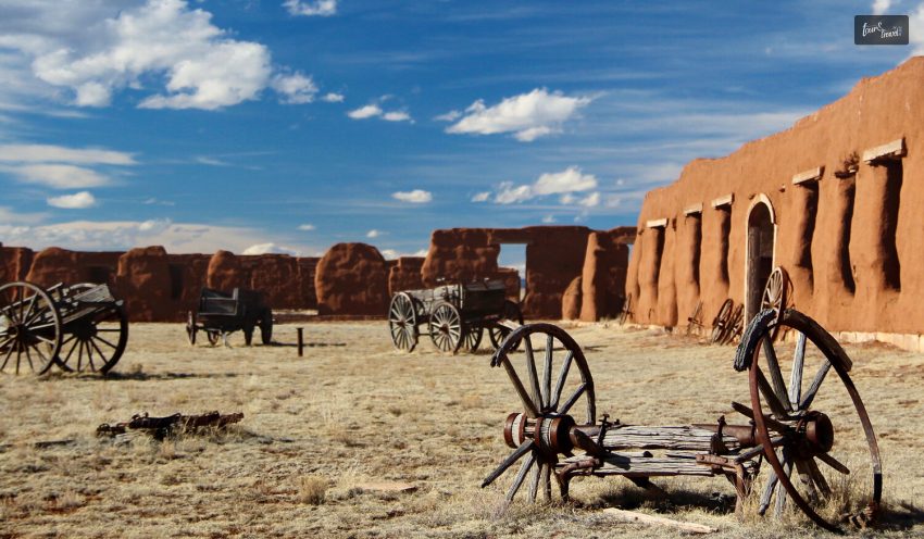
5. Fort Union National Monument
The territorial-style adobe remains of the greatest 19th-century military fort in the area are exposed to the wind. There is a broad valley of short grass prairie among the swales of the Santa Fe Trail. Fort Union served as a catalyst for political and cultural change in New Mexico and the Southwest for forty years. It happened from 1851 to 1891, whether those changes were wanted or not.
North of Watrous in Mora County, New Mexico, is where you’ll find Fort Union National Monument, a part of the US National Park Service. On June 28, 1954, the national monument was established.
The site includes the remains of the third fort as well as the second of three forts that were built there starting in 1851. A network of ruts from the Mountain and Cimarron Branches of the previous Santa Fe Trail is also discernible.
From a self-guided tour and a much interpretive trail where the guides take the visitors through the fort, to a short 0.5-mile walk with a special focus on some parts of the fort, the tourists can have it all here!
The Fort Union National Monument opens at 08:00 a.m. in morning and stays open till eight in the night. You can visit this place on Saturdays and Sundays.
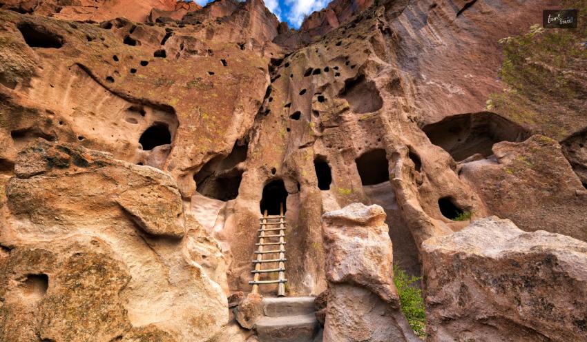
6. Bandelier National Monument
Another of the region’s top archaeological sites, the magnificent Bandelier National Monument, is located not far from Santa Fe. It is located on the Jerez Mountain slopes and has a tonne of amazing wilderness, as well as various Ancestral Puebloan sites scattered throughout its picturesque surroundings.
It was established in 1916 and now preserves some of the state’s most stunning, reachable, and substantial cliff homes. Visitors can explore caves, kivas, and ceremonial structures utilized by the Ancestral Puebloans for generations in Frijoles Canyon’s magnificent peach-colored surroundings. There are Petroglyphs and rock art too.
Even though it is the most well-known and picturesque location in the park, there are many more amazing things to see across the national monument, with delightful wildlife, landscape, and views everywhere you look. It also boasts a fantastic museum that displays ancient artifacts and finds from archaeology.
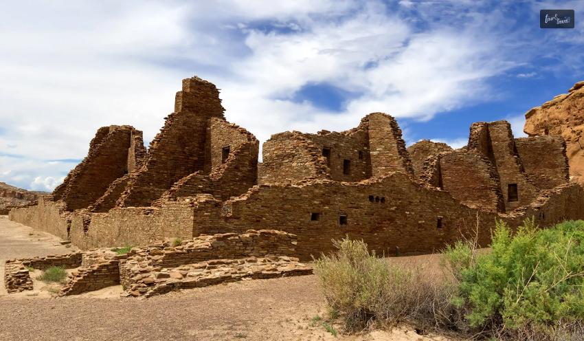
7. Chaco Culture National Historical Park
Northwest New Mexico is home to the fascinating Chaco Culture National Historical Park, one of the most significant and magnificent pre-Columbian cultural sites in the whole United States. It is one of the best national parks in New Mexico. Its expansive site, located within the Navajo Nation, safeguards a large number of historically significant pueblos.
Pueblo Bonita, built between AD 900 and 1100 from pieces of sandstone that have skillful placement. It was once the hub of Puebloan culture and trade. The ruins of several “great houses,” and other smaller structures are there all across the starkly gorgeous Chaco Canyon. Many of these are aligned with the sun’s and moon’s light and shadow patterns. In the wake of a protracted drought in 1130, everyone left their homes.
A network of old roads known as the Chacoan Roads connects the Chaco Culture National Historical Park to a number of formerly prosperous desert settlements. After visiting Chaco, go 75 miles north to the Aztec Ruins National Monument. It is a first-come, first-served campground at the end of a 21-mile dead-end dirt road. Here you will see another magnificent grand house and a recreated underground ritual space called a kiva.
The backdrop is equally stunning as the extensive archaeological sites, which are fascinating to investigate. The barren desert steppe has enormous mesas and stunning buttes. Visit the museum at the site before leaving. Learn all there is to know about the Ancestral Puebloans who once lived in the dry area.
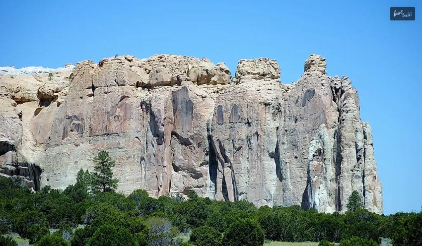
8. El Morro National Monument
Imagine how refreshing it would be to reach water after days of sand-filled journey. El Morro (the headland) was a well-liked camping area for hundreds of years. This is because of a dependable waterhole concealed in the base of a sandstone bluff. Over 2,000 signatures, dates, notes, and petroglyphs are here from prehistoric Puebloans, Spanish, and American travelers. Make a pit stop at the El Morro National Monument while traveling.
Two paths are there at El Morro National Monument. To select the path that’s best for you, stop by the visitor center and speak with a ranger. The tourist center is where all routes start and end.
Only when the visitor center is open can visitors access the trails of El Morro National Monument?. It is necessary to start hiking the Headland Trail by 3:00 PM. Before 4:00 pm, hikers who want to complete the Inscription Loop must start.
Let me give you some advice if you intend to visit the El Morro national park and want to know what to do there. On the Headland Trail, you can go hiking. The Inscription Loop is part of this 2-mile track, which also leads to the top of the El Morro bluff. With a 224-foot elevation climb, the course is somewhat challenging.
You can trek the Inscription Loop by taking a shorter trail. You can walk the half-mile trek to the pool You will pass through hundreds of Spanish and American inscriptions and ancient petroglyphs. The looping, half-mile asphalt trail is wheelchair accessible with some help. If you only have an hour or so to spend at the park, this is a fantastic option. It must begin at 4:00 p.m. at the latest.
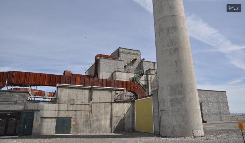
9. Manhattan Project National Monument
The Manhattan Project was a groundbreaking, top-secret government initiative during World War II that saw the United States race to create and use the first atomic weapons before Nazi Germany.
One of the most significant historical moments of the 20th century was the American employment of these weapons against Japan in August 1945. The project gave birth to the nuclear era and left behind profound impacts, still felt today. Three key places across the nation served as the birthplace of the Manhattan Project: Hanford, Washington; Los Alamos; and Oak Ridge, Tennessee.
The villages created to house the Manhattan Project personnel were private businesses and enterprises under contract with the project. Every community transformed into a hub of activity with theaters, shops, schools, hospitals, parks, and community gathering spaces.
The population of Oak Ridge had increased to roughly 75,000 by 1945. Richland, a Hanford Site bedroom suburb, witnessed an increase in population to 15,000, while Los Alamos had an increase to 6,000.
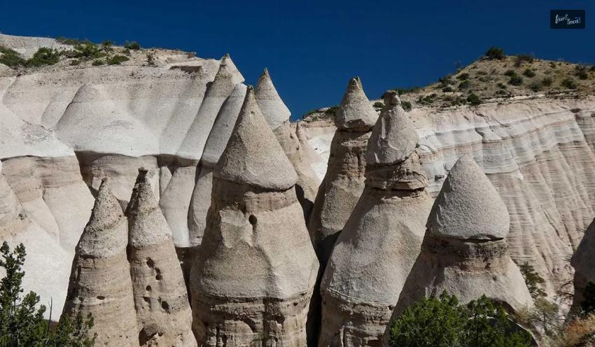
10. Kasha-Katuwe Tent Rocks National Monument
Less than an hour south of Santa Fe, Tent Rocks offers slot canyons, strangely beautiful rock formations, and breathtaking views—everything you could desire in a desert hike.
Before opening up beneath the 100-foot conical hoodoos that give this national monument its name, the three-mile trail’s first half winds through a slot canyon so narrow you can touch the walls on both sides. From there, the trail switches back up to the top of the mesa for a commanding view of the Jemez Mountains and the Rio Grande River Valley.
In the Keresan language, Kasha-Katuwe translates to “white cliffs.” The people of Cochiti Pueblo speak it, which also co-manages the monument. An eruption gave birth to the volcanic tuff that formed the white cliffs, hoodoos, and Slot Canyon.
Tent Rocks does not allow camping and the route is only open during the day, although the Cochiti Lake recreation area is close by and has built campsites. It makes for a wonderful day excursion because it is a short drive from old Santa Fe.
Wrapping It Up!
In case you were searching for the best national parks in New Mexico, I hope that this log has been of much help to you. If there are any other queries related to the same, feel free to let me know. All that you need to do is scroll down till you reach the bottom of the page, then leave your comments and queries in the box below, And I will be there to answer them all for you!
Ankita Tripathy loves to write about food and the Hallyu Wave in particular. During her free time, she enjoys looking at the sky or reading books while sipping a cup of hot coffee. Her favourite niches are food, music, lifestyle, travel, and Korean Pop music and drama.
The official document released by the House of Commons suggests that almost 42.5 million overseas residents visited the United Kingdom in the year 2024.
People generally travel to the United Kingdom to enjoy the diverse experiences the nation offers, including its history, nature, culture, and heritage.
They enjoy exploring various historic landmarks in London as well as the diverse natural scenic landscapes of Scotland and Wales.
However, you should always remain protected against any mishap. You should always plan for any unexpected event while planning the itinerary, accommodations, and transportation.
Having the right travel insurance in the United Kingdom ensures that you are financially covered for medical emergencies, trip interruptions, or unforeseen mishaps during your journey.
Choosing a suitable travel insurance for UK trip before departure should save you from stress and costs later on.
Do You Need Travel Insurance for the United Kingdom?
Healthcare in the UK is high-quality but can be expensive for visitors. Most tourists and short-term visitors are not eligible for free NHS care except in limited situations. making international travel medical insurance essential.
This type of insurance typically covers hospitalisation, doctor visits, and emergency treatments, helping you avoid large out-of-pocket expenses.
It also provides support services like medical referrals, emergency transport, and 24/7 assistance while you are abroad.
Factors To Consider When Choosing The Best Plans For Your UK Trip
There are several things to keep in mind when travelling to the UK. Hence, here are some of the factors that make purchasing travel insurance for UK trip very important.
1. Medical Coverage To Look For
While evaluating travel insurance for UK trip, people often forget to check for some of the most important factors.
Health expenditure for visitors in the United Kingdom is generally high. Thus, you should purchase a policy plan that incorporates the crucial elements.
Hence, your plan should incorporate things like.
Costs of stay and surgery in the Hospitals.
Proper coverage for doctor consultations, diagnostics, and prescribed medications.
Emergency medical evacuation to the patient's motherland, if required.
Treatment for accidents or sudden illnesses
2. Coverage Beyond Medical Emergencies
Medical cover remains critical. However, good travel insurance should also handle other unexpected situations. Travelling is full of uncertainties. Thus, you should be ready for sudden, unwanted surprises.
These surprises can include unwanted cancellations, sudden natural disasters, man-made problems like being robbed, and more.
Look for policies that include:
Trip cancellation or interruption due to emergencies or illness
Lost, delayed, or damaged baggage
Passport or document replacement assistance
Personal liability for accidental damages or injuries
These additional benefits help smooth out many common travel disruptions and protect your finances if something goes wrong.
Single Trip Vs Multi-Trip Plans For the UK
People often travel to the same place multiple times. Thus, they can definitely go for multi-trip insurance. You should choose between a single trip and multiple trips based on the number of visits to the country.
Moreover, the single-trip policies work great when you visit the UK for a fixed duration.
The single-trip policies remain ideal for people visiting places for leisure purposes. The single-trip policy mostly covers people from departure to return.
However, several people have to visit the country multiple times throughout the year. They often visit the UK for purposes like education, business, and others.
Thus, multi-trip visas typically suit the needs and requirements of those people who visit the United Kingdom multiple times, throughout the year.
The travellers can leverage multiple entries without renewing the policies for every trip. The purchasers of multi-trip policies should closely monitor factors such as trip durations, medical coverage caps, and other details.
How To Compare Travel Insurance Plans Effectively
The buyers should check the Insurer's claiming process and support network in the UK. The buyers of the insurance should get quick access to customer care.
Furthermore, the organization should provide transparent documentation and the ability to make claims online through their phone.
Moreover, these things play an important role during emergencies abroad.
Policies with complicated procedures or limited assistance can become frustrating when you need help most.
Moreover, people find it very difficult to navigate the procedural nuances when they are unfamiliar with a place.
You should not have to go to a country's embassy for any kind of help during these emergency situations.
All the processes should be manageable at the tip of your finger through your mobile phone.
Conclusion
Selecting the right travel insurance in the United Kingdom goes beyond just meeting visa requirements.
It is about safeguarding your journey against unexpected medical bills and travel-related costs.
Understanding coverage details, comparing options, and planning according to your travel style ensures a smoother experience.
Well-known insurers like TATA AIG offer international travel medical insurance options tailored for international travellers, including comprehensive medical coverage and additional protections, making them a practical choice to consider when planning your UK trip.
Frequently Asked Questions About Travel Insurance For Uk Trip
Here are the answers to some of the most commonly asked questions about travel insurance for a UK trip
1. Do I Need Travel Insurance For A UK Trip? Travel insurance is not really mandatory for travelling to the UK. However, you should get insurance for multiple reasons.Health expenditure in the United Kingdom generally remains high for travellers. Thus, travel insurance can save you during uncertainties. 2. How Much Does Travel Insurance Cost For The UK? The cost of purchasing travel insurance in the United Kingdom varies by plan. While single-trip insurance remains cheap, multi-trip insurance is generally costly. 3. Do I Need Travel Insurance To Enter The UK? Travel insurance is not really mandatory for travelling in the United Kingdom. However, travel insurance for a UK trip can save you in multiple situations. 4. Which Travel Insurance Is The Most Reliable? Reputed endurance providers like TATA AIG serve as trusted Insurers in the market. Moreover, they offer a range of insurance policies, including single-trip and multi-trip. 5. Do Visitors To The UK Get Free Healthcare? Visitors to the United Kingdom do not really receive free healthcare under the NHS. Thus, healthcare for visitors is generally more expensive.
Setting out on a road trip is unquestionably thrilling as well as liberating. Nothing compares to taking to the open road with the wind in your hair and stunning scenery rushing by.
A proper guide will help you discover the best routes so you never have to stress out while on your adventurous trip. You can experience some of the most stunning scenery to make your road trip worth all the traveling efforts.
Here is a list of the top six most beautiful road journeys globally to create a memorable road journey of all time.
The Most Mesmerising Road Trips: The List Of The Best
Here is a list of the most spectacular scenic road trips from around the world. So let's understand them here.
Pacific Coast Highway, California, USA
Driving the Pacific Coast Highway from north to south keeps you within the lane closest to the water, letting you experience the most heavenly coastline view. The Pacific Coast route follows US Highway 101 in Washington, Oregon, and at the northernmost point of California. Starting in San Francisco, travel south to Los Angeles, stopping in quaint communities like Santa Cruz and Monterey.
The West Coast is also notable for its number of well-preserved historic sites that stand as vivid reminders of life on what was once the farthest frontier of a new nation, in addition to the overwhelming scale of its natural beauty. Most of these sites have yet to be torn down, built on, or even built around.
Great Ocean Road, Victoria, Australia
The 243-kilometer Great Ocean Road winds past lush rainforests and beautiful beaches. It also glides by the recognizable Twelve Apostles limestone stacks as it travels down Australia's southeast coast. Look out for koalas in the treetops as well as whales breaching in the ocean as you travel from Torquay to Port Fairy. Remember to stop along the trip at the breathtaking Loch Ard Gorge and London Arch.
The magnificent Great Ocean Road follows the seashore cliffs that crisscross the untamed as well as the battered Southern Ocean. The famed road's breathtaking panoramas inspire awe. It has jagged cliffs, deserted beaches, and towering bluffs flanked by vivid green countryside,
Ring Road, Iceland
The Ring Road, commonly known as Route 1, should be at the top of your list of things to do when visiting Iceland. Visit South Iceland, the East Fjords, North Iceland, as well as the Snaefellsnes Peninsula, among other places, to see Iceland at its best. Students studying in Europe can quickly leave their Student accommodations, plan a road trip with their new friends, and create great memories.
The most incredible way to experience Iceland's most beautiful scenery is by taking the Ring Road around the island. Explore the tranquil Jökulsárlón Glacier Lagoon, take in the unearthly splendor of the Golden Circle, and unwind in the Blue Lagoon's geothermal waters.
Garden Route, South Africa
Stretching from Mossel Bay to Storms River, South Africa's Garden Route is a picturesque drive that showcases the country's diverse beauty. The Africa's Garden Route is a 750-kilometer-long route with lush forests, pristine beaches, and stunning landscapes. Visit the famous Tsitsikamma National Park, watch whales in Hermanus, and explore the Cango Caves in Oudtshoorn.
The Garden Route is also famous for its excellent wildlife spotting opportunities and adventurous activities such as shark cage diving and bungee jumping. The Africa's Garden Route can be a great road trip for young adult college students, and it it can also be a great reunion trip for old college friends who recently moved out of their student housing.
Transfăgărășan Highway, Romania
For an adrenaline-filled road trip, head to Romania and take on the mighty Transfăgărășan Highway. Marvel at the impressive Balea Lake, drive through hairpin bends and reach the highest point at the stunning Vidraru Dam.
The Fagaras Mountains, a component of the Carpathians, are crossed by the route as indicated by its name. These mountains, which separate western and southern Romania, are frequently called the Transylvanian Alps. The 90km (56 miles) long road ascents over the summits with ambition. It initially imitates a river and later just follows the ridges.
Route des Grandes Alpes, France and Switzerland
The genuine classic journey spans 684 kilometers (425 miles). It ascends over some of the highest as well as the most picturesque mountain passes in all of Europe. It encompasses Thonon-les-Bains on the shores of Lac Léman to Menton on the French Riviera.
As you drive from Lake Geneva to Nice, stop by iconic destinations like Chamonix, Val d'Isère, and the glamorous French Riviera. Make sure you give yourself enough time so that you may stop frequently. It is the most well-known tourist route in the French Alps, snaking through remote valleys and across high mountain passes.
Conclusion
The most stunning places on earth may be explored at your speed by taking a scenic road trip. So fill up the tank, gather your belongings, and get ready to embark on an exciting journey.
About AmberStudent - Amber Student is one of the leading platforms of student accommodation (2016) and has served over eighty million students from around the world. It is your one-stop destination for all your needs, mainly housing needs.
The experts of ember completely assist them. They secure housing far from your home. So look for our social platforms, Facebook as well as Instagram, and be on our journey!
Read Also:
The Easy Way to Travel in India
10 Useful Tips For Planning A Trip That You Will Love
Why Engage Competent Tourism Companies For Executing Best Leisure Time
What is an art museum? Have you ever visited an art museum? Have you been planning to visit museums in Austin recently? Here, I am making a list of museums in Austin, Texas, so that you can plan your itinerary according to your preferences.
Museums are a treasure of history, so when you walk into museums, you will feel as if you are walking back into history. The pace inside the museums feels like it has slowed down as you get to learn so much about the exhibits.
Informative and interesting museum exhibits ensure that all the artifacts are preserved. You can find literary manuscripts, objects, photographs, and rare books in these museums, which are several years old. This is why it is important to visit museums to learn about history and acquire inspiration from it!
The Best Museums in Austin for Every Interest and Age Group!
What museums are open in Austin? So, what's the largest museum in Austin? It is, of course, the Blanton Museum, and I will be sharing with you the little details related to it. There are other museums of course which you should be visiting when in Austin.
Blanton Museum Of Art
https://www.instagram.com/p/C0_-PzwOK7i/
This museum is one of the largest and most significantly comprehensive art collections in Central Texas, Austin! There are more than 21,000 pieces in permanent collections in the museum. The museum authorities organize special events regularly and regulate exhibits.
If you are planning to go, why don't you try to visit on Tuesdays? This museum offers free admission on Tuesdays.
Bob Bullock Texas State History Museum
https://www.instagram.com/p/CvH-TT_IZLk/
The museum has been named after the 38th lieutenant governor of the state! When you visit this museum, you will learn a lot of information. Therefore, it offers educational and meaningful experiences on the history of Texas.
They organize culturally enriching exhibits and provoke your thoughts regarding historical events. You can visit the museum from Monday to Sunday between 10 am to 5 pm, while the admission prices range from $9 to $13.
The Contemporary Austin
https://www.instagram.com/p/CZ7wVZGO5oQ/?img_index=1
To check out contemporary and modern art, you must visit The Contemporary Austin. This museum has two locations: Jones Center in Downtown Austin and Laguna Gloria in Lake Austin.
If you want to visit this museum with your family, this is the perfect place because they organize seasonal exhibits and educational events. You must see it from Wednesday to Sunday from 9 am to 3 pm.
On Thursday evenings, you can visit from 6 pm to 9 pm! You must pay $10 for adults, while for senior citizens and students, you must pay $5; for the military, it is free.
George Washington Carver Museum & Genealogy Center
https://www.instagram.com/p/B7TzjYaFuYq/
The museum is in East Austin, and it celebrates the global contributions of black people. When you visit the museum, you will be bound to feel emotional because it preserves the history and culture of African American culture. The museum reflects a beautiful aesthetic expression!
In this museum, admission is completely free. So how do you know when to visit? You must visit the website to learn about the current times you can see the museum. So, you must visit Monday to Wednesday from 10 am to 6 pm.
You can visit the museum on Thursday from 10 am to 9 pm; on Friday, you must see it from 10 am to 6 pm.
Elisabet Ney Museum
https://www.instagram.com/p/C4OqD_1pfn4/
When you visit this museum, you will have a fun and unique experience with the photo ops. I recommend you visit this museum because it is highly recommendable and offers you a diverse view of art and exhibits.
The museum is historic because it is the home and studio of Elisabet Ney! She is known as a wildly iconoclastic German sculptor who moved to Austin in 1882.
There are self-guided tours that you can take when you visit this museum. You can visit the museum from Wednesday to Sunday as the duration is from 12 pm to 5 pm. For further information, you can visit their website.
Neill-Cochran House Museum
https://www.instagram.com/p/C1h9OFGJ-oN/
The museum is quite magnetic as it is inside a huge, beautiful mansion with an interesting history. A self-guided tour is available, and friendly staff will help you check out different aspects of this museum.
The museum authorities organize educational exhibits. When attending, you will feel like you have stepped back in time. Why don't you check the website for more details to see if it is included in your itinerary?
The museum is open from 11 am to 4 pm, Wednesday to Sunday. On Thursday and Friday, visits are from 11 am to 4 pm.
The Contemporary Austin - Laguna Gloria
It was an estate that has now been turned into a museum venue and an outdoor garden. You will be tremendously happy and attracted once you visit this museum, as the beautiful sculptures are in the park.
These outdoor sculptures are perfect for exploring and enjoying the Colorado River's view. The museum is closed on Monday and Tuesday and open from Wednesday to Friday from 9 am to 3 pm.
Texas Memorial Museum
https://www.instagram.com/p/C3IlmFYsp1d/?img_index=1
In Austin, if you want to visit a museum that will excite your children, you must visit the Texas Memorial Museum. This museum's dinosaur fossils and other exhibits are impressive, so what are you waiting for?
Take your kids or your partner, friends, or family who are dino lovers. The exhibit features a t-rex skull, flying pterosaur, and complete mosasaur. Why don't you check out their website to learn about the exhibits and the time of visit?
From Tuesdays to Saturdays, the museum is open from 10 am to 5 pm; on Sundays, it is open from 1 pm to 5 pm. It is mostly closed on all major holidays and Mondays!
Old Bakery & Emporium
This museum is one place where you can buy art and crafts as they offer beautiful crafts and handmade items. Some friendly volunteers will help you understand the beauty of the exhibits.
If you want to buy unique gifts, this is the perfect place to shop. This museum is near the capital and is easily accessible. It is through a website where you can check out many details.
The museum is open from 10 am to 6 pm from Wednesday to Friday, but on Saturdays, you can visit the museum between 12 pm and 5 pm.
Mexic-Arte Museum
https://www.instagram.com/p/Cmy3h4NN9Di/?img_index=1
The museum is a collection of contemporary Mexican art that mainly focuses on the works of artists who work with contemporary Mexican art. There are texts available to understand the art in bilingual texts, such as Spanish and English.
You can visit the museum if you want to buy something to give someone because there is a gift shop attached there. This museum is open from Monday to Thursday from 10 am to 6 pm, while on Fridays and Saturdays, it is open from 10 am to 5 pm.
On Sundays, the museum is open from Noon to 5 pm. So why don't you visit this place?
Finishing Off…
To sum it up, all these museums offer diverse art, their representation, and artists interpret beauty. I am sure you will love all the museums' exhibits and art that talks so much about the history of the places and the people.
If you can relate to the culture and want to know more about ancestors of old times, go ahead and check out one of these museums. It will be a perfect activity to entertain you and your kids for a long time.
Comment on which museum you plan to visit in Austin and tell us why!
Read More About:
Is Savannah Safe? What You Need To Know Before Visiting!
Is San Francisco Safe? THIS Is What You Should Know!
Is Cabo San Lucas Safe? – Let’s Find Out!


 Related