
Knuckles Mountain Range Sri Lanka: A Guide To The Wildest Central Highlands Of Sri Lanka

Aug 21, 2026

Last Updated on: Sep 30, 2026

Asia

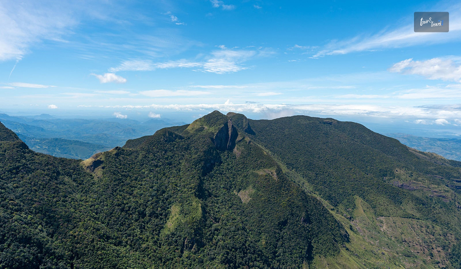
I saw the Knuckles Mountain Range from a distance, and I knew where it got its name from. 

Near Riverston, the ridgeline transformed into a row of rounded peaks with unique folds.

The folds further made it look like a clenched fist against the sky.

I was expecting an extension of Nuwara Eliya or the charm of Ella in the Knuckles Mountain Range. 

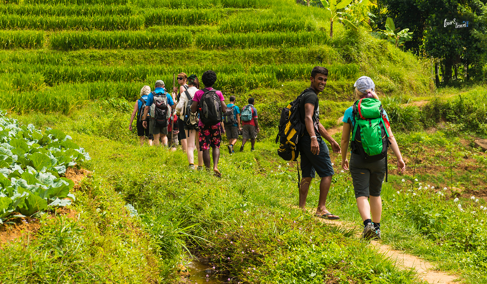
However, instead of the tea estates, I got days of cloud forest, leech socks, and village guides.

Also, I experieced a silence so complete that I could hear my own footsteps on the trail.

Also, if you have loved Horton Plains National Park, you will definitely cherish the Knuckles Mountain Range, the less-polished and wilder counterpart.

Where The Knuckles Mountain Range Is And The Mystery Behind Its Name

Knuckles Mountain Range Sri Lanka: A Guide To The Wildest Central Highlands Of Sri Lanka

The Knuckles Conservation Forest is in the Central Highlands of Sri Lanka.

It is between the Kandy and Matale districts and at a distance of around 30 to 40 kilometers northeast of Kandy Town.

Furthermore, it stands between the Kandy and Matale districts.  

The Mountain Range gets its name from five or six peaks that you can see from certain angles.

These peaks, with their folds and unique round shapes, resemble knuckles on a closed fist.

However, the local name for the mountain range is Dumbara Kanduvetiya.

The name means the “misty mountain range.” 

Honestly, I could relate to this name more during my visit.

On the two days I visited the mountain range, the Sun was not out even at 9 AM. 

In 2010, the Knuckles Mountain Range got the designation of a UNESCO World Heritage Site as part of the Sri Lankan Central Highlands listing. 

It got the designation because of how many distinct climate zones and endemic species are packed into a relatively small area.

How To Reach The Knuckles Mountain Range?

Most people base themselves in Kandy or the small village of Meemure, Corbett’s Gap, or Hunnasgiriya before heading in.

I stayed in a homestay near Hunnasgiriya, which cut my morning drive to the trailhead down to about 40 minutes.

FromDistanceApprox. Travel Time
Kandy30–42 km (depending on trailhead)1.5 to 2 hours by tuk-tuk or car
Colombo140 km4 to 4.5 hours by car
Matale25 km1 hour
Dambulla45 km1.5 hours

There is no train access into the range itself.

So, a hired vehicle, tuk-tuk, or your own transport is essentially mandatory. 

Roads narrow into single-lane gravel past Loolwatte, and a couple of the approach roads are only comfortable in a 4WD or trail bike during monsoon months.

What Makes Knuckles Different From Other Highland Parks

Knuckles Mountain Range Sri Lanka: A Guide To The Wildest Central Highlands Of Sri Lanka

If you have already read up on Horton Plains, you will know that the park is essentially a single well-marked loop trail to World’s End. 

Knuckles is the opposite.

It is a sprawling, largely unmarked forest reserve with more than 35 identified peaks and a dozen-plus trail combinations, most of which require a local guide.

I hired mine through the Forest Department office near the Wattegama entrance, and I am glad I did.

Without him, I would have missed the point entirely where the trail splits toward Deer Park versus the summit route.

Flora And Fauna

The range spans five distinct climatic zones within a 20-kilometer radius, which is unusual anywhere in the world. 

On my hike, I moved from dry-zone scrub near the base.

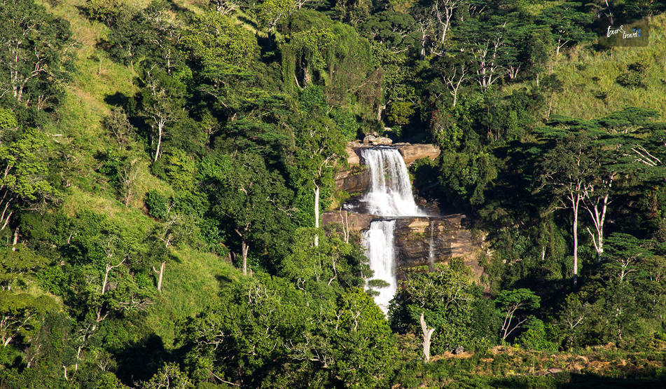
We hiked through a submontane forest thick with orchids, into genuine cloud forest by midday, where the canopy dripped constantly even without rain.

FeatureDetails
Elevation range300 Meters to 1,863 Meters (Knuckles Peak)
Endemic plant speciesOver 160 Recorded
Bird speciesAround 128 Bird Species, including the Endemic Sri Lanka Whistling Thrush
Notable wildlife•Purple-faced Langur
•Rusty-Spotted Cat
•Kandyan Drongo
Best known peaks•Knuckles Peak
•Gombaniya
•Corbett’s Gap
•Deer Plateau

I did not spot the rusty-spotted cat, and almost nobody does.

However, I did have a long, unbothered staring match with a purple-faced langur troop near Deer Park.

Also, the birdlife alone was worth the leech bites.

Popular Trails And What To Expect

Knuckles Mountain Range Sri Lanka: A Guide To The Wildest Central Highlands Of Sri Lanka

You can choose the loops and trails in the Knuckles Mountain Range based on the kind of experience you want. 

The Meemure Loop

This is the trail most guides recommend for a first visit.

It is a roughly 10-kilometer loop through the traditional village of Meemure, one of Sri Lanka’s most isolated settlements.

It is still reachable only by a single mountain road. 

I spent a night here in a village home, ate red rice and jackfruit curry cooked over a wood fire.

I was left with a much better sense of why people describe Knuckles as a living landscape rather than just a park.

Corbett’s Gap And Riverston

If you have limited time, Riverston is the easiest win. 

It is a short drive-up viewpoint rather than a trek.

On a clear morning, the “Bible Rock” formation and the valley below are genuinely dramatic. 

I would treat this as a half-day add-on rather than the main event.

Knuckles Peak Summit Trail

This is the demanding one. 

It is approximately a 14-kilometer round trip with a real elevation gain, usually done as a full-day hike starting before dawn. 

Expect grassland patches, patana grass ridgelines, and a scramble near the top. 

I would not recommend it without a guide or without reasonable fitness.

Parts of the descent were harder on my knees than the climb up.

TrailDistanceDifficultyTime Needed
Riverston / Corbett’s Gap1–2 Km ViewpointsEasy2–3 Hours
Meemure Loop10 KmModerateFull day / Overnight
Knuckles Peak Summit14 km round tripChallengingFull day (Start Pre-Dawn)
Deer Park Trail6 KmModerateHalf Day

Practical Tips From My Trip

•Leeches are real and constant in the wetter zones, especially June through September.

So, leech socks aren’t optional.

I learned this the hard way on day one.

•Weather flips fast.

I packed for cold cloud-forest mornings and sweated through humid valley afternoons on the same day.

•A guide is genuinely necessary for anything beyond Riverston.

Trails are not signposted, and the Forest Department requires registered guides for most routes anyway.

•The best season is broadly February to April and August to September, avoiding the heaviest southwest monsoon rains.

•Phone signal disappears past Hunnasgiriya on most networks, so download offline maps beforehand.

•Entry to the Knuckles Mountain Range is free.

However, based on the loop you take, the trekking and permit charges will be between LKR 1000 and LKR 2500. 

Where To Stay Near The Knuckles Mountain Range?

Options are simple by design. This is not a resort destination. 

Homestays in Meemure and Loolwatte give the most authentic experience.

On the other hand, Hunnasgiriya and Corbett’s Gap have a handful of small eco-lodges with better amenities if you want a hot shower after the hike.

Knuckles Mountain Range: The Ultimate Remoteness Of Sri Lanka

Knuckles won’t give you the manicured, easy-access experience of Horton Plains or the tea-country views of Nuwara Eliya. 

What it gives instead is a genuine sense of remoteness.

I found village life largely untouched by tourism.

I came across a forest that changes character every few hundred meters of elevation, and trails that still require a bit of local knowledge to navigate. 

If World’s End felt like Sri Lanka’s highlands on display, Knuckles felt like walking into them. 

I am already planning a return trip to attempt the summit trail from the Deanston side, weather permitting.

Share on Social Media

Sibashree is a travel, culture, and leisure writer who has been writing since the age of 12 and professionally since 2014. With more than a decade of travel writing experience and journeys across India and several parts of the world, she brings a deeply personal and thoughtful perspective to her work. A student of English Literature and Mass Communication, Sibashree has always viewed travel as more than movement — for her, it has been a way of understanding people, cultures, and herself. Her passion for spiritual exploration has also led her to many unusual and meaningful destinations over the years. Outside of writing, Sibashree enjoys watching European cinema, reading about global politics, and reflecting on the stories hidden within everyday places.

Leave a Reply

Your email address will not be published. Required fields are marked *

title-img Related

READ MORE Peradeniya Botanical Garden

A Slow Walk Through Royal History: My First-Person Guide To Peradeniya Botanical Garden

BY  Sibashree Sep 10, 2026

While setting my Kandy itinerary, I thought Peradeniya Botanical Garden would take around two hours. However, I ended up staying four hours in the botanical garden. Still, I felt that I rushed through exploring the spice garden. The time it demands is not just because of its expansion. Every section of the park is worth stopping for.  In this article, I will give you a walkthrough of Peradeniya, along with the fees, timings, and route details I gathered along the way. A Quick Snapshot Before You Visit The Peradeniya Botanical Garden DetailInformationOfficial NameRoyal Botanic Gardens, PeradeniyaLocationPeradeniya, about 5.5 km west of Kandy, Central ProvinceEstablishedIn 1821 as a formal botanic gardenThe site was a royal pleasure garden earlier, under the Kandyan kings.SizeRoughly 147 acres (about 60 hectares), Sri Lanka's largest botanical garden.SettingHeld within a wide loop of the Mahaweli River, the island's longest river.Managed byDepartment of National Botanic Gardens, Sri LankaPlant CollectionMore than 4,000 species, including a well-known orchid collection.Opening Hours7.30 AM - 6.00 PMTicketing Hours7.30 AM - 5.00 PMAnnual VisitorsAround 1.2 million local and 400,000 foreign visitors in a typical year. Sources: Department of National Botanic Gardens The Royal History Behind The Gardens A walk around Peradeniya helped me realize how much of Kandyan royal history is tied up in this particular loop of the Mahaweli River. From Royal Pleasure Garden To Botanic Institution Before the British formalized it in 1821, the Peradeniya Botanical Garden was a royal pleasure garden. The Kandyan kings were the patrons of the site, and it was especially dear to the last queen of Kandy.  Six years after the fall of the Kandyan Kingdom to the British in 1815, the land was converted into a proper botanic garden. It was initially managed by Alexander Moon and centred on coffee and cinnamon cultivation before it grew into the far broader collection it is today. A Living Library Of Over 4,000 Species Today, the park has more than 4000 plant species. You will see palms, ferns, orchids, and shrubs from across the world. So, within the same park, you will walk from the spice garden to the giant bamboo grove. It is like a mix of different ecosystems along the riverbank.  What I Found Walking Through The Gardens Peradeniya spans across 147 acres. So, it is not possible to cover the entire area on a single visit.  So, pace yourself rather than making an attempt to see everything at once.  The Royal Palm Avenue This is the postcard shot everyone takes, and for good reason.  Rows of towering royal palms line a long, straight avenue, and the scale of it is more impressive in person than in any photo I had seen beforehand. The Spice Garden I lingered longest here.  Cinnamon, nutmeg, vanilla, and other spices grow as actual plants rather than the packaged versions most visitors are used to. Also, having someone point out which bark strip becomes the cinnamon on a supermarket shelf made the whole spice trade history of the island feel a lot more concrete. The Orchid House The Orchid House displays Cattleya, Dendrobium, Arachnis, Oncidium, Phalaenopsis, and Vanda varieties and their hybrids, including specimens of Tiger Orchid, the largest orchid species in the world.  I would budget more time here than you think you need. It is easy to walk through in ten minutes, but worth thirty. The Giant Javan Fig Tree And Giant Bamboo These are two of the garden's most photographed non-flowering specimens. There is a sprawling Javan fig with a canopy wide enough to shade a small crowd. Also, the bamboo grove with stalks reaching over 30 metres. ] Both feel less like garden features and more like landmarks in their own right. The River Loop And Great Lawn The Mahaweli River wraps around most of the property. The paths along that loop are noticeably quieter than the main avenues. If you want a break from the crowds near the entrance, this is where to find it. A Realistic One-Day Itinerary TimeWhat I did7:30 – 8:30 AMArrive at openingStart at the Royal Palm Avenue while the light is still soft and the paths are quiet.8:30 – 9:15 AMExploring the Spice Garden with cinnamon, nutmeg, and vanilla plants. 9:15 – 10:15 AMVisiting the Orchid House, then the surrounding orchid garden.10:15 AM – 11:00 AMVisiting the Giant Javan fig tree and the great lawn near the river loop. 11:00 – 11:45 AMExploring the Fernery and the quieter riverside paths.11:45 AM – 12:30 PMVisiting the Giant bamboo grove, then a slow walk back toward the entrance. Planning Your Visit: Fees, Timings And Getting There Visitor CategoryAdults (12+)Children (5–12)Under 5Foreign VisitorsLKR 3,540 LKR 1,770FreeLocal VisitorsLKR 200LKR 30Free The charges for foreign schools and students are LKR 2,360. However, they need to produce the right proof.  Also, for local senior citizens with NIC proof, the entry fee is LKR 50.  How To Reach Peradeniya? Peradeniya sits less than 5.5 kilometres from central Kandy on the Colombo road, which makes it one of the easiest half-day trips out of the city. Take a short tuk-tuk or taxi ride, or a public bus running the Kandy–Peradeniya route.  Several local operators also combine it with a Kandy city tour, pairing the garden with the Temple of the Tooth and viewpoints around town in a single outing. Best Time To Visit Unlike Hakgala Flower Garden, Peradeniya's lower elevation and river-loop setting mean it is a comfortable visit almost year-round. However, a few things are worth timing around. Early morning (7:30–10:00 am) for cooler temperatures and quieter paths. The dry inter-monsoon months for the most reliable weather, since Kandy still sees regular rainfall through much of the year. Weekdays over weekends, since school groups and local families tend to fill the garden on weekends and public holidays. Tips From My Visit To The Peradeniya Botanical Garden Wear comfortable shoes. The paths are flat and wheelchair-friendly, but the total distance covered adds up quickly across 147 acres. Electric buggies and golf carts are available for rent. The 4-seater electric cars cost LKR 1000 per hour, and the 8-seater vehicles cost LKR 2000 per hour.  Carry water and sun protection. Despite the tree cover in places, long stretches of the main avenues are fully exposed. For photography, the light along the Royal Palm Avenue is best in the first hour after opening. Nearby Places To Combine With Peradeniya Botanical Garden Because it sits so close to Kandy, Peradeniya rarely needs to be its own dedicated day trip. The Temple of the Tooth Relic and central Kandy are easy extensions to a trip to this botanical garden.  Also, don’t forget the University of Peradeniya campus, which borders the gardens. Moreover, if you want a journey onward to the hill country, you can include Nuwara Eliya in your itinerary.

READ MORE pasikudah

What Are The Things To Do In Pasikudah? Know The Place Where The Indian Ocean Forgets How To Be Rough

BY  Sibashree Jul 25, 2026

Pasikudah is getting its first floating dining platform thanks to Sun Siyam. So, this coastal town around 35 km away from Batticaloa is going to offer a more luxurious experience.  While this is a delightful upgrade, the first thing I noticed in Pasikudah was the silence.  With the sands and turquoise waters that almost looked surreal, it was away from the crowds.  Also, the absence of crashing surf and urgent pull made exploring the shoreline easier for me. There was no need for reminders to stay close to the shore.  Furthermore, in the south, at Unawatuna Beach and Mirissa Beach, the Indian Ocean threw itself at land with real intent.  At Pasikudah on the eastern coast, it was just a gentle lapping, the kind of sound that makes you lower your voice without realizing it. The shore here waits for the Ocean to arrive! How To Reach Pasikudah? Pasikudah is at a distance of around 300 kilometers from Colombo.  So, if you are traveling from Colombo or straight from the Bandaranaike International Airport, it will be a road journey of five to six hours.  A little taxing it may sound, but it can be a wonderful opportunity for cultural exploration. The road takes you through the Cultural Triangle of Anuradhapura, Polonnaruwa, and Kandy. The key destinations on this circuit also include the Sigiriya Rock Fortress and the Dambulla Royal Cave.  However, during my trip to Sri Lanka, I took the 6075 Batticaloa Special train from Colombo Fort to the Valaichchenai Railway Station.  This is the closest to Pasikudah, and you can reach the coastal town in 15-20 minutes in a tuk-tuk.  The train started at 3:15 PM and reached Valaichchenai Railway Station at 10:50 PM. I was traveling in a third-class compartment, and the ticket price was LKR 1400.  There are two other train options from Colombo Fort to Pasikudah. The first one leaves at 6 AM and reaches Valachchenei at 2:40 PM. Also, the last train for the day departs from Colombo Fort Station at 7 PM and reaches Valachchenei at 3:23 AM. Pasikudah: A Place With A Multilayered History Pasikudah shows Tamil influence in its naming, and it is roughly translated to “Green Algae Bay.” The name is, of course, not flattering for a place that looks this beautiful. However, it ties the link perfectly to the past when Pasikudah was a working fishing settlement. It became a resort town much later.  Furthermore, Pasikudah is the place where the Dutch first landed in Sri Lanka in 1602. I could see the traces of that Colonial period scattered everywhere.  There were old buildings, a slender lighthouse, and a fort dating to 1628 with sweeping views over the coastline, about 20 minutes away near Kalkudah. 2004 And 2009: Two Landmark Years For The History Of Pasikudah And Sri Lanka  The history of Pasikudah got erased twice in recent years.  The Tsunami in 2004 hit this stretch of coast hard.  Also, decades of Civil War kept Pasikudah off the tourist map entirely until the war ended in 2009, like Kilinochchi and Mullaitivu.  Standing on the beach, I watched families wade out into water that barely reached their knees even 400 meters from shore. It was hard to picture how quiet and forgotten this coastline was less than two decades ago.  The recovery of this resort town has been consistent and, in places, quite luxurious.  However, the bones of an old fishing village are still there. What Are The Things To Do In Pasikudah?  Pasikudah is not a beach that you visit for drama or some out-of-the-box adventure.  You can chase that in the moody coastline I found in Mannar or the raw remoteness of Vavuniya.  Here the water is the whole point, and the things to do in Pasikudah revolve around that.  1. Exploring The Shallow Reef Coastline  Pasikudah has one of the longest stretches of shallow reef coastline in the world.  I walked out nearly 500 meters from the shore one morning, and the water still sat at my waist. It was dreamy, and it felt like the ocean had turned into a very warm and large swimming pool.  Also, the shallow gradient makes it an ideal snorkeling spot.  I spent an afternoon drifting over coral patches just offshore. I watched for the reef fish that dart in and out of the structures close to the resort strip.  Diving operators here also run trips further out for anyone wanting more depth than the bay itself provides. Moreover, if you are traveling with kids, it is one of the safest beaches in Sri Lanka. So, you will usually notice families visiting this beach and not the usual surf crowd.  2. Experiencing The Rawness Of Kalkudah The tuk-tuk ride to Kalkudah in the north was a brilliant decision as it impressed me with its quieter and rawer feel.  Kalkudah had fewer sun loungers and resorts and more fishermen.  I spent half a day on a coastline that was not fully smoothed out yet. 3. Exploring Beyond The Beach I wanted to get inland for at least one day.  So, I took a drive south and reached Batticaloa town. Batticaloa had its own Dutch fort and a slower, more local rhythm than the resort strip. I loved wandering its lagoon-side streets in the afternoon and talked to fishermen whose families had been working in the same waters for generations.   Then I explored the lagoon system of Batticaloa by bicycle and saw rice paddies, water buffalo, and small fishing communities up close.  I rented the bicycle from a local operator, and they charged me 300 LKR per hour.  4. A Visit To The Somawathiya National Park The Somawathiya National Park is at a distance of around 68 km from Pasikudah. It is a protected site known for its biodiversity.  It has leopards, elephants, water buffalo, and various species of birds,  Also, it is a prominent pilgrimage site with the stupa housing the relic (the right canine tooth) of Lord Buddha.  The experience at Somawathiya National Park was very different from the time at the beach, and the Somawathiya Chaitya reminded me of the Great Stupa at Sanchi in Madhya Pradesh, India.  Overall, Pasikudah rewarded me as a place to slow down. However, with enough history and the spiritual vibe of the Stupa, my time here was more rewarding.

READ MORE Wilpattu National Park

Wilpattu National Park: Chasing Leopards Through Sri Lanka’s Wild Lakelands

BY  Sibashree Sep 8, 2026

My driver, Dasun, stopped the jeep beside a villu, one of the signature natural lakes of Wilpattu. Our jeep had been idling by villu for around 20 minutes. Then, suddenly, our tracker killed the chatter and pointed.  I spotted a leopard moving along the far treeline. His body language was unbothered, and it seemed that he was in no rush at all.  Also, there were no jeeps fighting to capture the spot for taking a photo. The absence of radio crackling and other trackers converging on the spot further added to the experience.  Overall, the moments here told me everything about why Wilpattu is quietly considered Sri Lanka's most serious leopard park, even though Yala National Park gets most of the international attention. Furthermore, Wilpattu is the largest in Sri Lanka, and it feels like it.  Also, I noticed a clear difference between Yala and Wilpattu. Yala’s blocks can feel congested because of the safari traffic in peak season.  However, the sheer scale of Wilpattu and its remoteness from the southern tourist circuit keeps visitor density low even when sightings are excellent.  Wilpattu National Park At A Glance Wilpattu is in the North Western and North Central Provinces of Sri Lanka.  It straddles the boundary near Puttalam and Anuradhapura districts.  The villu system defines this national park. The villu system has a network of roughly 60 natural, sand-rimmed lakes scattered through dense scrub and forest. Also, it is the villu system from which the park gets its name. The meaning of Wilpattu is “The Land of Lakes” in English.  Moreover, thanks to the water network, the park has many predictable spots for animal concentration.  So, despite the massive scale, the chances of spotting wildlife here are excellent.  DetailInformationLocationNorth Western and North Central Provinces, near Puttalam and AnuradhapuraAreaApprox. 1,317 Square KilometersIt is Sri Lanka's Largest National ParkKey FeatureAround 60 Natural "Villu" Lakes Set in Dense Dry-Zone ForestSignature WildlifeSri Lankan LeopardSloth BearElephantSpotted DeerMugger CrocodileNearest CityAnuradhapura: Approximately 30 KmPuttalam: Approximately 40 KmRecommended Visiting MonthsFebruary to October How To Reach Wilpattu National Park? You can approach Wilpattu from the Cultural Triangle via Anuradhapura. Also, you can take the northwestern coastal route via Puttalam and Kalpitiya. Both these routes are straightforward and sealed.  However, the final stretch to the main Hunuwilagama entrance narrows into a quieter rural drive. FromApproximate  DistanceApproximate Drive TimeAnuradhapura30 Km45 MinutesPuttalam40 Km1 HourKalpitiya75 Km1.5–2 HoursColombo180 Km3.5–4 HoursNegombo150 Km3 Hours Again, there is a second and less-used entrance on the Mannar side of the park.  It is for those travelling the north-south coastal route, though most safari operators and lodges are clustered around the main Hunuwilagama gate near Anuradhapura. Inside The Park: My Safari Experience I planned a full-day safari in Wilpattu National Park, and it was from 6 AM to around 4 PM.  A park safari is the best way to see Wilpattu properly. A half-day barely gets you past the entrance loop before you have to turn back. The Villus: Wilpattu's Signature Lakes The villus make the ecology of Wilpattu different than any other national park in Sri Lanka.  These are not man-made reservoirs. These are natural rain-fed lakes ringed with pale sand, and the jeep tracks are laid out to string several of them together. Also, every meaningful sighting I had came from parking quietly at a villu edge and waiting rather than driving in search of animals.  Crocodiles were basking at the waterline, and elephants were drinking water. Finally, the leopard appeared along the treeline.  Leopards And The Chance Of A Sighting Wilpattu is often described by naturalists as having a leopard density comparable to Yala's famous Block 1, without anywhere near the crowd.  Sightings are not guaranteed on any single visit, and practically no park can promise that. However, the odds, combined with the calmer viewing experience when a leopard does appear, are a big part of why serious wildlife photographers increasingly prefer Wilpattu over Yala in peak season. Elephants, Sloth Bears, And Birdlife As I have mentioned, elephants are frequent around the villus and the drier months are the best time to spot them.  Also, the park has around 30 recorded mammal species, including sloth bear, water buffalo, sambar, and mongoose. Furthermore, it has a strong birdlife presence. I could spot painted storks and several kingfisher species around the lake edges.  Peacocks and hornbills are more common sightings among birds in this park.  What Is The Best Time To Visit Wilpattu National Park? You can take part in safaris year-round.  However, the park is ideal between February and October. These months are ideal for avoiding the heavier northeast monsoon rains. Rain makes interior tracks difficult and reduces visibility.  Also, in a day, early morning and late afternoon remain the most productive windows for activity, as the midday heat pushes most animals into cover. Entrance Fees And Safari Costs Wilpattu is among Sri Lanka's higher-tier national parks for entrance pricing. The entry fee is less than Yala National Park. However, it is above smaller Category 2 parks.  Recent traveller reports and 2026 pricing guides put the all-in foreign adult entrance cost, including entry, service charge, vehicle fee, and VAT. It is roughly USD 29–30 per person, with jeep hire priced separately and negotiated locally. Fee ComponentApproximate Cost (Foreign Adult)Park EntranceServiceVehicleVATUSD 29.50 per AdultUSD 17.70 Per Child (6 to 12 Years)Guide/Tracker Fee$7 to $10It is Often Bundled into the Jeep PackageHalf-Day Jeep HireApproximately LKR 12,500 (6 AM to 10:30 AM)Full-Day Jeep HireApproximately LKR 25,000 (6 AM to 6 PM) A Full-Day Wilpattu Itinerary Given the park's size, a full day is genuinely worth the early start. Here is roughly how my day broke down. TimeActivity5:30 AMDepart lodge and arrive at Hunuwilagama entrance.6:00–9:00 AMMorning safari loop through the northern villus. 9:00–9:30 AMBreakfast break at a designated stop inside the park.9:30 AM to 12:30 PMContinue tracking toward the larger central villus.12:30 PM to 1:30 PMMidday rest as animal activity drops with the heat.1:30 PM to 4:00 PMAfternoon loop, best window for leopard and elephant activity. Where To Stay Near Wilpattu? You can choose from simple guesthouses in Anuradhapura, which put you within easy reach of both Wilpattu and the ancient city's ruins, to dedicated eco-lodges and tented camps right on the park's buffer zone near Hunuwilagama.  Staying inside or immediately adjacent to the buffer zone shaves a meaningful amount off your pre-dawn drive time, which matters if you want to be at the gate for the 6 am opening. The guesthouses in Wilpattu cost around LKR 3500 per night, and if you are staying in the ecolodges around the buffer zone, the charges will be approximately LKR 7500.  Tips From My Visit A few things I would tell anyone planning a Wilpattu trip. Book the full day rather than a half-day if your schedule allows, since the best villus are further from the entrance. Pack your own food and water, as very little is available once you are inside. Also, pay for the jeep and entrance in Sri Lankan rupees only, since foreign currency isn't accepted at the gate. Places To Visit Near The Wilpattu National Park  Wilpattu's location makes it an easy pairing with the cultural triangle. Anuradhapura's ancient stupas and monasteries are barely half an hour away, and it is a natural stop for anyone routing between the north and the northwestern coast.  Travelers continuing toward the coast often carry on to Kalpitiya for kitesurfing and dolphin watching, or further north toward Mannar and Vavuniya. Again, Chilaw, with its lagoon and temple circuit, also makes a workable stop if you're driving down from Wilpattu toward Colombo.