


 Related
7 Best National Parks In Ohio You Should Know Before Going
BY Abdul Aziz Dec 27, 2021
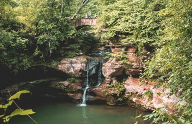
Are you a nature lover? Then, Ohio is the best place for the travel enthusiast. Ohio has hundreds of natural cliffs, hiking trails, and camping parks. Further, all the federal parks in Ohio are irresistibly beautiful and are full of natural beauty. When you look at the map of Ohio, you will acquire knowledge about how many national parks are there in Ohio. The number of national parks in Ohio is eight. Further, the national parks in Ohio are the best tourist spots for national and international travelers. They are also the most popular camping spots. So, at Tour and Travel, we have decided to give you a brief idea about all the Ohio national parks. These places are great as budget-friendly tourist destinations and explore the nature and culture of Ohio at its best. List Of All 8 National Parks In Ohio If you are living nearby Ohio and still do not have ideas of camping in federal parks in Ohio. You have missed the beautiful view of nature. All the national parks in Ohio are becoming the best hanging-out spot for every adventure sports-loving person. Here are the names of the seven most popular Ohio national and state parks. 1. Cuyahoga Valley National Park Address: Ohio, USA Hours Open: 24 Hours Contact Number: +1 440-717-3890 Fees: Free Cuyahoga Valley National park is one of the best national parks in Ohio. This national park lies between Cleveland and Akron. And it is situated along the Cuyahoga River. With the natural preserving beauty of the national park, the rich history of the place makes the park a unique tourist place. This national park is carrying the history of 19th-century waterway Canal exploration. On the north side of the park, a canal exploration center is present to deliver historical impressions to the visitors. The Cuyahoga Valley railroad runs through the park, making the place more unique. This wildlife park is the home of amazing native wildlife and plants. Where to get a national parks access pass in Ohio? You only have to Buy the American annual pass and enjoy the park. The annual pass system has a special discount for military professionals and children. 2. John Bryan State Park Address: 3790 OH-370, Yellow Springs, OH 45387 Hours Open: One and a half hours before Sunrise to half an hour after Sunset Contact Number: +1 937-767-1274 Fees: Free John Bryan state park is an extensive 752-acre state national park in Ohio. You hear about the Miami River, and This large green park is just right below the yellow spring and the Clifton. This park is a prevalent clamp ground among the local people. Apart from the beautiful scenic beauty, the long industrial history of the United States is adding more points. In the 19th century, industrial activity increased; therefore, water is no longer the economic source of water. For this reason, many of the factories are getting abandoned. And no longer in use. But the Clifton mill, which was built in 1802. This mill is now becoming a popular visiting place among tourists. 3. Nelson-Kennedy Ledges State Park Address: 12440 OH-282, Garrettsville, OH 44231 Hours Open: 7 AM to 7 PM Contact Number: +1 330-235-0030 Fees: Free This park is a 167-acre public recreation park. When you are near Nelson township, this place is the best hiking spot for you. The Ledge park is full of hiking trails and camping spots. Beautiful waterfalls and native green plants are making this park look like heaven. This park is one of the best hiking spots for travelers as well as the national parks in Ohio. Nelson Kennedy ledges state park has a 3 miles long hiking trail. As the park is situated on the natural landscape. Many dangerous paths are present in the park, but the marked hiking trails are guiding the right path of hiking. 4. Mohican-Memorial State Forest Address: 975 O D N R Mohican Road 51, Perrysville, OH 44864 Hours Open: 24 Hours Contact Number: +1 419-938-6222 Fees: Free Have you seen the movie "The Last of The Mohican"? The natural beauty of the shooting spot is still getting most of the viewer’s attention. This state forest is situated in Ashland country, Ohio. This forest is quite popular among forest researchers. This large 4525 area of forest area is carefully looked over by the Ohio Division Of Natural Resources. This is the third most popular tourist destination in the United States. The Clear Fork River and Pine’s major streams are the two major rivers of the park. The park’s best feature is 32 miles hiking, 22 miles bridle, 8 miles snowmobile, and 24-mile mountain biking trails. 5. Hueston Woods State Park Address: 6301 Park Office Rd, College Corner, OH 45003 Hours Open: 24 Hours Contact Number: +1 513-523-6347 Fees: Free This park lies in oxford city Ohio. The park belongs in the Butler and Pable country of Ohio city. It covers nearly 3000 acres of area and has 625 acres of a human-made lake. The state was bought in 1941. Initially, it was a prison camp, and after 1957 the park was open to regular visitors. And now, this is one of the best national parks in Ohio. This park has 12-mile long hiking trail and 19 miles of bridle trails along with 20 miles of mountain biking trails. The place’s camping facility is very organized, along with the hiking trails, golf course, and lodging facility. 6. Hocking Hills State Park Address: Logan, OH 43138 Contact Number: +1 740-385-6842 Hours Open: 10 AM to 5 PM Entry Fee: Free Are you searching for any national parks near Columbus, Ohio? Hocking Hills State Park is a good choice for you. This park belongs in the hocking hills region. A big part of Hocking state forest belongs in the hocking hills state park. This park has seven separate types of hiking areas, including different hiking trails. Cantwell Cliffs, Ash Cave, Conkle's Hollow, Old Man's Cave, Rock House, Cedar Falls, and a popular hiking route Hemlock Bridge Trail to Whispering Cave 7. Charles Young Buffalo Soldiers Address: 120 US-42, Wilberforce, OH 45384 Hours Open: 9 AM to 4:30 PM (Monday Closed) Contact Number: +1 937-352-6757 Fees: Entry Free Do you want to see a national monument in Ohio? Visit this park, and you can see monuments along with enjoying the beautiful natural view. Charles Young Buffalo is one of the historical figures in his first days of life. He was an escaped slave. He was the first afro American soldier in the United States army. The house of the Buffalo soldier is one of the famous historical destinations among travelers. This is one of the most popular iconic monuments in Wilberforce, Ohio. When you plan to visit the Ohio parks, do not forget to visit this monument because the American civil war history was attached to this monument. 8. Dayton Aviation Heritage National Historical Park https://www.instagram.com/p/CjxhlbMMIAw/?img_index=1 Address: 16 S Williams St, Dayton, OH 45402 Contact Number: +1 937-225-7705 Hours Open: 9 AM to 4 PM (Monday Closed) Entry Fee: Free For all the literary enthusiasts and dark academia fans, Dayton Aviation Heritage National Historical Park in Ohio is one of the best places to visit. It remembers Paul Laurence Dunbar, an eminent poet and author. The park also honors the aviation pioneers Orville and Wilbur Wright. A tour of this park will be a fulfilling and educational experience. Throughout the park, you will come across the following important spots: Carillion Historical Park Wright Cycle Shop Huffman Prairie Flying Field Paul Laurence Dunbar House Wright-Dunbar Interpretive Center Huffman Prairie Interpretive Center You can even opt for a ranger-guided tour of this best national park in Ohio. The only disadvantage of the park is that it does not have a camping ground. So, you cannot stay here. However, you can always put up your tent in the private and public campgrounds near the park. So, check out the website of the Greene County Convention & Visitors Bureau to locate and reserve the campgrounds. Frequently Asked Questions On National Parks In Ohio (FAQs) Q1: What is the newest state park in Ohio? A: Jesse Owens state park is the newest state park in Ohio. it is named after a world-famous athlete. It was created in the year 2018 out of a coal mining land that was owned by American Electric Power. Q2: Which is the smallest state park in Ohio? A: Oak Point state park is known to be the smallest one in Ohio. Measures at 1.5 acres, despite being the smallest state park, it still offers a wide range of facilities for boaters, sightseers, and picnickers. Q3: Are state parks free in Ohio? A: Ohio is one of the few states in the country that do not charge general admission and parking fee at its 74 state parks. Wrapping It Up: All the Ohio state parks camping is the most favorite for the fitness enthusiast. The collection of these places are the most popular tourist destination among local and international travelers. National parks in Ohio list quite a long list. But these seven parks and sites are the best places where you can enjoy the hiking trails and camping. If you are planning to visit Ohio parks for adventurous hiking, do not skip these popular parks. So what is your plan to visit? Do not forget to comment back to us.