

Bakers Falls: The Reward At The End Of The Horton Plains Loop

By the time I heard Baker’s Falls, my legs already knew we were on the return leg of the Horton Plains loop. 

We had started before sunrise to beat the mist at World’s End, walked the open plateau in that strange, cold, grassland light, and then dropped back into cloud forest for the final stretch. 

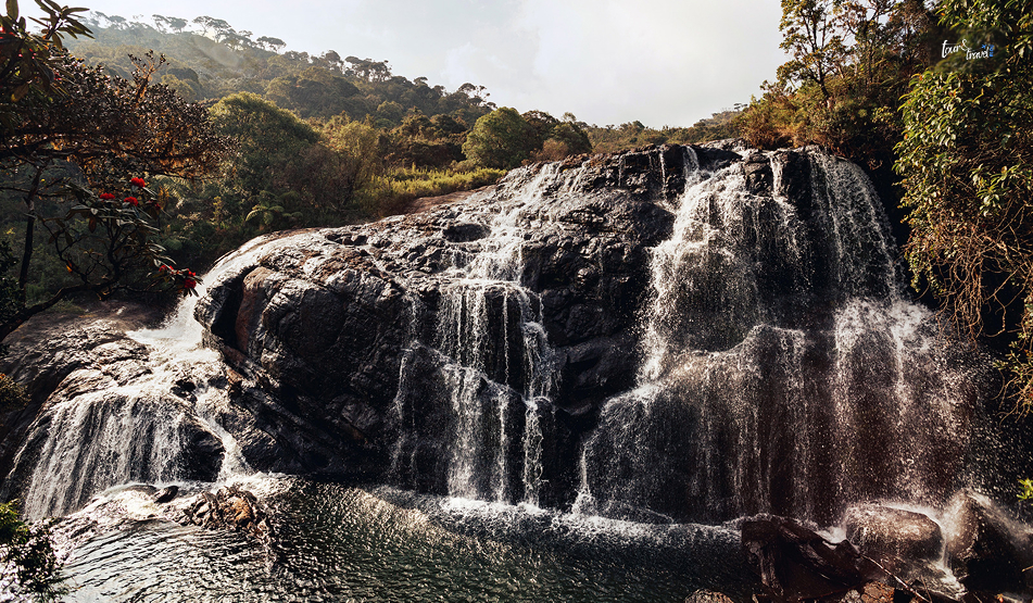
The falls announced themselves before they appeared as a low rush of water through the trees.

After the wide-open plains, that first glimpse of water tumbling over dark rock into the ferns felt almost intimate by comparison.

Baker’s Falls Quick Facts

DetailInformation
HeightAround 20 Meters
WidthAround 25 Meters
RiverBelihul Oya, a Tributary of the Walawe River
LocationHorton Plains National Park, Nuwara Eliya District
Distance from EntranceAround 3 Km from the Main Loop Trail
Full Loop Distance9.5 Km Round Trip, including Bakers Falls and World’s End
Park ElevationAround 2100 to 2300 Meters
Entry FeeEntry Fee to Horton Plains National Park, No Additional Fee
Named AfterSir Samuel Baker, a British explorer, who is said to have come upon it in 1845

Where Is Bakers Falls And How To Reach?

Bakers Falls: The Reward At The End Of The Horton Plains Loop

Baker’s Falls is inside Horton Plains National Park in the Nuwara Eliya District. You have to walk from the entrance along the main park trail to reach Baker’s Falls. 

Belihul Oya, a major tributary of the Walawe River, has formed this waterfall. 

Reaching The Park Entrance

You can reach Horton Plains National Park from Nuwara Eliya, at a distance of around 32 km. 

You can also travel from the towns of Pattipola and Ohiya, both of which sit on the upcountry railway line. 

If you are traveling by train, you will have to hire a tuk-tuk or taxi for the final stretch to the gate.

The Hike To The Falls

You can reach Baker’s Falls via the park’s main loop trail.

The same trail also takes in Little World’s End and the main World’s End escarpment. 

From the entrance, it is about 4 km to World’s End, then roughly 2 km further around the loop to Baker’s Falls, and another 3.5 km back to the entrance.

So, it is a 9.5 km round trip in total, usually taking about three hours at a comfortable pace. To reach the water itself, you’ll descend a set of steps from the main trail down to the viewing area.

World’s End: The Rest Of The Loop

Almost nobody visits Baker’s Falls on its own.

It is one stop on the wider Horton Plains circuit, alongside Little World’s End (a roughly 300 m drop) and the main World’s End escarpment, where the plateau falls away nearly 880 m.

Horton Plains is unusual among Sri Lanka’s national parks in that visitors can walk the main trail independently, without a mandatory guide.

However, hiring one at the entrance is a good way to learn more about the park’s cloud-forest ecology and resident sambar deer.

What Makes Baker’s Falls Worth The Walk

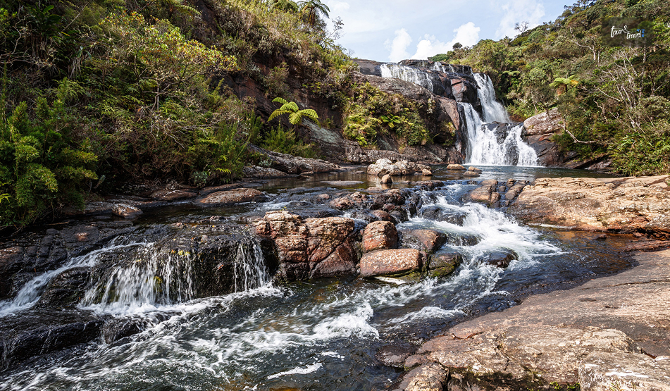
Baker’s Falls is modest by Sri Lankan standards, with a height of around 20 meters.

It is dwarfed by giants like Bambarakanda further south. 

But its setting is what makes it memorable. 

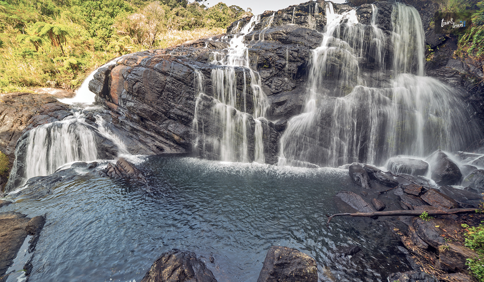
The Belihul Oya spreads across a wide, dark rock face in two stages, hemmed in by rhododendron and tree-fern growth that feels completely different from the open grassland just a couple of kilometres back up the trail. 

Originally known as Gonagala Ella, the falls were renamed after Baker, who is credited with discovering them during his time exploring and hunting in the Nuwara Eliya highlands.

After the exposed walk to World’s End, where wind and cold are the main things you are contending with.

The descent into the forest around Baker’s Falls is a genuine change of pace. It is quieter, greener, and sheltered. 

Most people treat it as the natural place to stop, catch your breath, and refill water before the final stretch back to the entrance.

What Is The Best Time To Visit Bakers Falls?

Bakers Falls: The Reward At The End Of The Horton Plains Loop
SeasonMonthsWhat to Expect 
Dry SeasonJanuary to AprilBest overall conditions.
Clearer views at World’s End and easier underfoot.
Wet SeasonMay to SeptemberFrequent Mist, Especially After Mid-Morning
Slippery Trail Sections
Early MorningAny Season, Before 9-10 AMEssential for a Clear View at World’s End Before the Cloud Rolls in.

A One-Day Itinerary: The Full Horton Plains Loop

Bakers Falls: The Reward At The End Of The Horton Plains Loop
TimeStopNotes
5:30 AMDepart Nuwara EliyaStart Early to Beat the Mist at World’s End
6:30 AMArrive at Park EntranceBuy Tickets and Start the Loop Trail. 
7:15 AMLittle World’s EndFirst Viewpoint, About 45 minutes in
7:45 AMWorld’s EndThe Main Escarpment
Aim to Arrive Before 9 AM for Clear Views
9 AMBaker’s FallsRoughly 2 Km Further Along the Loop.
Descend the Steps to the Base.
10:30 AMReturn to EntranceFinal 3.5 Km Stretch Back Along the Trail.
11:30 AMDepart for Nuwara EliyaYou Can Also Continue Toward Ella if Heading Further into the Hill Country. 

Practical Tips To Keep In Mind For A Trip To Baker’s Falls

  • Start before sunrise because World’s End is frequently shrouded in mist by mid-morning, especially from April to September.
  • Wear proper hiking shoes as parts of the trail are uneven. Also, the steps down to Baker’s Falls can be slippery.
  • Pack warm layers. Horton Plains sits above 2,000 m and mornings are cold, even though the walk itself will warm you up.
  • There is no swimming at the pool below Baker’s Falls. It is deeper than it looks and has a history of drownings.

We reached the park entrance again a little after ten, legs tired and jackets finally shed. 

Of everything on the Horton Plains loop, World’s End is the view people talk about. However, Baker’s Falls is the one I would send someone back for on its own.

Share on Social Media

Sibashree is a travel, culture, and leisure writer who has been writing since the age of 12 and professionally since 2014. With more than a decade of travel writing experience and journeys across India and several parts of the world, she brings a deeply personal and thoughtful perspective to her work. A student of English Literature and Mass Communication, Sibashree has always viewed travel as more than movement — for her, it has been a way of understanding people, cultures, and herself. Her passion for spiritual exploration has also led her to many unusual and meaningful destinations over the years. Outside of writing, Sibashree enjoys watching European cinema, reading about global politics, and reflecting on the stories hidden within everyday places.

Leave a Reply

Your email address will not be published. Required fields are marked *

title-img Related

READ MORE lahugala national park

Lahugala National Park: A Quiet Corner Of Sri Lanka’s Wild East

BY  Sibashree Sep 8, 2026

I was quite content at Arugam Bay for a week of surfing, and I had Kumana penciled in as one of my big wildlife detours.  I had heard about Lahugala, but most guides or locals I met mentioned it in passing.  It was more like, “Oh, that little park on the way to Pottuvil, you'll drive past it anyway.” However, an elderly guesthouse owner told me not to skip it. I listened to him. Otherwise, I would have missed the most understated, elephant-dense pockets of wilderness.  It was not like anything I had visited in Sri Lanka. Also, the best part was that I had it almost entirely to myself.  The park neither can nor tries to compete with Yala National Park or Wilpattu in scale or star power.  It is 5.4 square kilometres of flat, tank-fed scrubland in the Eastern Province, and that smallness is precisely the point. Everything in Lahugala revolves around water, grass, and elephants, and on the afternoon I visited, all three came together in a way I still think about. A Quick Introduction To Lahugala National Park Lahugala Kitulana National Park is in the eastern province of Sri Lanka, and it is roughly 16 Km inland from Arugam Bay.  It is also just off the Pottuvil–Monaragala road, which actually cuts through the park's southeastern edge. This park began its journey as a wildlife sanctuary in July 1966. Then, on 31st October 1980, it had an upgrade as a national park.  Furthermore, the ecology of the park revolves around the three ancient tanks, Lahugala, Kitulana, and Senagamuwa. These tanks eventually drain into the Heda Oya River. Nevertheless, have a look at the quick snapshot below before you plan a visit to Lahugala National Park.  DetailInformationLocationEastern Province, near Pottuvil and Arugam BayAreaApproximately 15.4 sq kmEstablishedSanctuary in 1966National park status on 31 Oct 1980Key featureThree Interconnected TanksLahugalaKitulanaSenagamuwaFamous forElephant gatherings around Lahugala tank, especially in the dry seasonNearest townPottuvil (approx. 16 km)Arugam Bay (approx. 16–18 km)Best seasonYear-roundElephant sightings are strongest July–September How To Reach Lahugala?  You do not need to plan a standalone trip for Lahugala National Park.  Like most travelers, I reached Lahugala from Arugam Bay. The tuk-tuk price was LKR 3000, and it took around 45 minutes.  Furthermore, the distance between Colombo and Lahugala is around 378 kilometers. So, if you are traveling from Colombo, choose Ella or Monaragala as your overnight stop.  Attempting the national park from Colombo will be an overly ambitious plan.  FromApprox. DistanceApproximate Drive TimeArugam Bay16–18 kmAround 30- 45 MinutesPottuvil16 km20–25 minutesMonaragala45 km1 hourColombo378 km6–7 hours The A4 Highway from Pottuvil to Monaragala runs directly alongside and briefly through the park. So, you do not even need a dedicated safari transfer to see part of Lahugala.  So, you can see a major section of the tank and grassland from the main road.  However, if you want to explore the interior tracks or the tank edges, you will need a park-registered tracker and jeep.  My Safari Experience At Lahugala National Park It was around 3:30 PM when I reached Lahugala. From the locals, I already knew that it was the ideal window for the classic dawn safari here.  The heat is at its peak in the afternoon, and that is what pushes elephants toward the tanks.  So, in the late afternoon, you will find them near the tanks.  The Elephants Of Lahugala Tank The Lahugala Tank supports a thick growth of Sacciolepis interrupta, a wetland grass elephants seem to genuinely love.  I saw herds gathering along the tank margins to graze on it.  The herds I came across had a decent strength of 20 to 30 elephants. However, the guide told me that during the peak season, there can be around 100 elephants in a herd.  Also, one thing I want to share here. The largest herd I spotted in the park was nowhere near the known gathering spots.  I saw them across the far bank and in the shallows.  Overall, barring the famous gathering of Minneriya, this was the largest elephant encounter I had in Sri Lanka.  I loved the elephant watching experience here because of how unhurried it felt.  No other jeeps were jostling for position, and there was no radio chatter about a sighting three tracks over.  My tracker cut the engine near the tank edge, and we simply sat and watched calves wade in, and adults strip grass with their trunks for close to forty minutes. Birdlife Along The Tanks The three tanks of Lahugala made it an exciting spot for bird watching. The park especially stands out with its population of waterbirds.  I picked out painted storks, several egret species, cormorants, and a pair of white-bellied sea eagles working the thermals above the water. Because the park is so rarely crowded, birds tend to stay closer and longer than they would somewhere busier. Sloth Bears And Other Wildlife In the park, I saw spotted or axis deer, sloth bears, along with mugger crocodiles and freshwater turtles.  However, to be honest, sloth bears are elusive, and you can spot them by luck.  They are shy. So, even if you cannot see them, know that they are present in the park.  What Is The Best Time To Visit Lahugala National Park? Lahugala National Park is a year-round destination.  However, if you are in the park especially for elephant gatherings, dry months are the best time to spot them.  During the dry months of July to September, elephant sightings become frequent, with the water levels dropping elsewhere and the gigantic creatures gathering around the tanks.  Also, you must avoid the northeast monsoon period from October to January. The tanks are full in these months, and the elephants disperse into the surrounding forest, making sightings far less predictable. Entrance Fees And Permits CategoryApproximate Cost (2026)Foreign Adult (12+)USD 12Foreign Child (6–12 Years)USD 6Foreign Children under 6 Years FreeSAARC NationalsUSD 10 for AdultsUSD 5 for Children between 6 and 12 YearsFree for Children below 6 YearsLocals Adults: LKR 60Children from 6 to 12 Years: LKR 30Children below 6 Years: FreeStudents: LKR 20Vehicle Entry TicketLKR 300Foreign Group Fee Per VehicleUSD 10 A Half-Day Lahugala Itinerary Because Lahugala is small, it is easy to pair with either Arugam Bay's beaches or a longer Kumana National Park excursion. Here is roughly how I had structured the afternoon based on my own visit. TimeActivity2:30 PMDepart Arugam Bay 3:00 PMArrive at Lahugala entrance, collect tracker3:30–4:45 PMSafari loop around Lahugala tank, elephant and bird watching4:45–5 PMStop at the old Magul Maha Vihara ruins near the park boundary5:15 PMReturn to Arugam Bay in time for sunset Tips From My Visit A few practical notes I will pass on. Go in the late afternoon rather than dawn, since Lahugala's elephant activity peaks as the heat pushes them toward water. Bring binoculars, as the tank is wide and animals often graze on the far bank. Do not expect the density of jeeps you will find in Yala National Park. This is one of the few parks in Sri Lanka where a wildlife sighting still feels unhurried and private. Nearby Places To Explore Lahugala sits at the crossroads of Sri Lanka's east coast and its deep south, which makes it easy to fold into a longer itinerary.  If you are basing yourself in Arugam Bay, it pairs naturally with a Kumana National Park safari for a more thorough wildlife day.  Travellers heading further south along the coast often continue on toward Pasikudah or Nilaveli for beach time. Again, those coming from the cultural triangle sometimes route through Mullaitivu or Vavuniya on the way east.

READ MORE best beaches in thailand

What Are The Best Beaches In Thailand For Families? Here Are The Ones I Loved

BY  Sibashree Jun 18, 2026

As the names of the World’s 50 best beaches get declared, three beaches in Thailand get shoutouts. These are the Freedom Beach, Paradise Beach, and Donald Duck Bay.  Also, with popular hubs such as Pattaya and Phuket, beach tourism is a major driver of the blue economy and the GDP of the country.  However, beyond these facts and accolades, the best beaches in Thailand, for me, are important because of the “Feel.”  The clear water, soft sand, and the warm hospitality of the place make it one of a kind. Furthermore, the landscapes starlight out of a storybook offer the quintessential tropical charm.  However, while traveling with my kids, I decided to focus more on the best beaches in Thailand beyond the commercial hubs such as Phuket. I wanted to take them to smaller regions where they could relax and feel the intimacy.  So, in this article, I will talk about the best beaches in Thailand for families, with Ao Nang in focus. I have also included the names from Phuket and Koh Lanta.  Ao Nang In Focus: The Best Beaches In Thailand For Family  As I have mentioned, despite Phuket getting most of the attention, Ao Nang is more suitable for a family vacation.  It has calmer waters, dramatic scenery, and a more authentic, community-centric environment for children. No wonder that Ao Nang in Krabi Province has emerged as the most overlooked gem among the beaches in Thailand.  The overall experience here is more authentic, and it offers a community-centric environment for children.  And here are the best beaches in Ao Nang I visited and loved.  Pai Plong Beach: The Ultimate Jungle Adventure Pai Plong is one of the best beaches in Thailand for families because of the soft golden sand. Furthermore, reaching the Pai Plong Beach is an adventure in itself. Children especially will love it.  How To Reach The Pai Plong Beach Via The Monkey Trail?  To reach the hidden cover, we took a walk along the main Ao Nang beachfront until we reached the start of the famous Monkey Trail.  This hiking path passes through a lush and dense jungle. Walking was quite adventurous but convenient with elevated boardwalks and wooden steps.  Furthermore, my kids were thrilled to have such close encounters with local monkeys. So, the excitement built up even before hitting the ocean.  Scenery And Swimming Beauty At The Pai Plong Beach  The Pai Plong beach is smaller than the neighboring public bays. However, the visual punch was unmatched.  It has surreal limestone cliffs and a striking karst island sitting just off the coast.  Furthermore, it was a welcome relief from the world-famous and overcrowded Railay Beach. Also, as a mother, the best part was the texture of the beach. The sand was soft. So, I did not have to check frequently whether any of them had toppled over and gotten a cut or gotten hurt.  In addition, the water was crystal clear, and the sea floor was entirely free of painful sea urchins. So, the kids could splash around safely without heavy water footwear.  2. Phra Nang Cave Beach: A Crystal-Clear Paradise Phra Nang Cave is another world-class coastal destination when you are traveling through Krabi with your family.  Even if many people consider Railay Beach to be the ultimate spot in the area, Phra Nang is actually a clear winner by miles.  How To Reach The Phra Nang Cave Beach?  The journey to the Phra Nang Cave Beach is an exciting experience. We took a traditional Thai longtail boat from Ao Nang to the Railay peninsula. As we stepped off the boat, we had to walk for around 20 minutes through a scenic route.  The path meandered through quiet and quaint villages, and the entire route runs alongside a vertical and majestic limestone mountain.  Moreover, the road is well-shaded, and it is full of biodiversity. We got to see playful monkeys on the route.  However, I got a little scared seeing the giant monitor lizards.  What Are The Best On-beach Activities For Children On The Phra Nang Cave Beach? The ocean water is so clear that we could easily spot schools of tropical fish around our ankles. We did not even have to wear a snorkel mask.  Furthermore, kids love the rock climbing spectacles here as professional climbers scale the massive and overhanging limestone crags right on the edge of the sand.  Moreover, there is this secret sandbar walk. During some tide windows, we could spot a pristine and shallow sandbar. We walked right across the ocean on the sandbar to explore a nearby rocky island.  3. Noppharat Thara Beach: The Golden Shell-Collecting Haven Noppharat Thara Beach is an ideal place if your family prefers tranquility and wide-open spaces.  Away from crowds, this beach is more popular as the “Other Beach” in Ao Nang. It is also less commercialized.  We took a quick tuk-tuk ride to reach the beach from the town. You can even plan a walk for 20-30 minutes from the town.  Unending Golden Sand And Natural Cleanliness Guarded by giant karst limestones on both horizons, the Noppharat Thara Beach boasts a long stretch of golden-brown sand.  The beach was pristine in the truest sense, and it was a relief seeing no litter or discarded garbage on the shoreline.  This is so hard to find on the beaches of Southeast Asia.  Noppharat Thara Beach Has A Thriving Ecosystem For Little Explorers  Young kids and inquisitive toddlers will love the shoreline covered in thousands of intact, beautifully colored marine seashells. Even I could spend hours collecting and sorting those seashells. Furthermore, as the ocean water stays calm and shallow at a distance from the shore, the beach is safe for toddlers and youngsters to swim.  In addition, you can spot thousands of miniature crabs and tiny sea snails in the damp sand here. So, overall, the beach offers an interactive learning session for the kids.  Planning A Day Trip To Hong Island (Ko Hong) From Ao Nang After spending some time on the mainland, we decided to go for a day trip to Hong Island from the Ao Nang coast.  We chartered a private longtail boat from the boatman's collective located at the northern edge of Ao Nang Beach. Once the boat arrived at Hong Island, getting off it was a lot of fun. We had to disembark onto a floating pier and not directly on the sand.  It is a great move to protect the delicate shoreline. However, before you leave the dock, take a note of the specific boat number and ask the captain about the exact pick-up time in the afternoon.  We also went to the National Park. The entry fee for the national park was around 400 Thai Baht for adults, and for children, it was free admission.  Here are more attractions for travelers on Hong Island.  The Hidden Turquoise Lagoon A key highlight of visiting Ko Hong is journeying into its hidden inner lagoon. Most organized day tours include this stop.  Your boat captain will slowly pilot the vessel through a breathtakingly narrow opening in the towering rock walls.  Once inside, the water becomes beautifully shallow and shifts into a brilliant, glowing shade of turquoise.  The lagoon is entirely encircled by vertical, jungle-covered cliffs, creating an enchanting environment for kids.  Powder-White Sand And Protected Swimming Once you arrive on the main island, skip the exposed southern beach and head directly to the far northern tip.  Here, you will find a secondary lagoon that is completely shielded from the rough open ocean. This area offers perfectly calm, waveless water.  Hong Island easily rivals Railay Beach in raw beauty. While Railay features darker golden sand, Ko Hong boasts brilliant, blindingly white sand.  The sand texture is incredibly soft, feeling exactly like talcum powder underfoot. However, note that it sticks stubbornly to wet skin and clothes. Park signs and automated loudspeakers frequently remind visitors to wear life jackets while wading.  Additionally, the shallows contain jagged chunks of bleached coral reef and sharp, broken shells.  It is highly recommended to pack durable water shoes for the family to avoid cuts.  The Educational Tsunami Nature Trail As my kids were getting restless sitting on a beach towel, I took them on a 15-minute break to explore Hong Island’s interior nature trail.  The path features highly educational English interpretive signs.  These include profound historical accounts detailing exactly how the island was impacted by the devastating December 26, 2004, Indian Ocean tsunami.  While walking through the dense brush, keep a sharp eye out for the island's native residents: massive water monitor lizards.  These docile reptiles grow so large that children frequently mistake them for real Komodo Dragons. Overrated Icons: Why Railay And Ao Nang Main Beach Can Disappoint Families Railay Beach and the primary Ao Nang town beach are the two suggestions you will usually get when you search for the best beaches in the Krabi region.  However, there are practical reasons why I have not included them in my list of the best beaches in Thailand.  Railay Beach: The Longtail Boat Traffic Jam  The Railay Beach is visually stunning, and it has dramatic limestone peaks that jut straight out of the clear ocean water. Furthermore, the massive rock walls completely cut off the peninsula from the mainland. So, you can only reach it by boat.  This logistical setup creates the biggest problems for families.  Noise, Exhaust, And Crowds The constant presence of longtail boats is one of the major problems with Railay Beach.  Dozens of commercial transport boats gather right offshore and create a dense cluster in the center of the beach.  Furthermore, the boats have unmuffled and loud automotive engines. This process creates a near-constant roar, and it prompts strong fuel exhaust fumes across the sand. This ruins the peaceful tropical ambiance. Rocky Shallows And Missing Shells Thousands of tourists walk these sands daily during the high season. As a result, you will hardly find interesting pieces of coral or seashells for kids to collect.  Furthermore, the ocean floor here stays shallow and clean for a long distance. However, there is the presence of jagged and hidden rocks.  Moreover, you have to wear sturdy water shoes if you want to visit the beach for snorkeling and kayaking.  Ao Nang Main Beach: A Busy Transit Hub The main municipal beach running directly along the primary resort strip is noisy and has high traffic.  So, you can visit this as an important transportation hub, and it is not suitable for a swimming beach.  Furthermore, here are the following main problems with the Ao Nang Main Beach. Endless Rows Of Water Taxis  The water of the Ao Nang Main Beach has a continuous line of a massive row of longtail boats. These longboats wait to ferry tourists away to cleaner, offshore islands.  Pollution Concerns  Many sections of the beach have significant environmental issues.  One of the issues is the large municipal drainage pipes empty directly across the open sand into the surf line.  As a result, this can cause unpleasant odors near the runoff zones. Litter In The Sand  There is constant foot traffic from the shops and bars nearby. Furthermore, you will find a noticeable amount of garbage embedded in the sand. Furthermore, the garbage in the sand includes sharp metallic beer bottle caps. So, it is hazardous to walk barefoot in the sand here.  Comparing Alternatives: Phuket And Koh Lanta If you want to go beyond Krabi and explore more beaches in Thailand, you can visit Phuket and Koh Lanta.  Both islands have many beaches for the kids. However, these beaches are vastly different in their environments.  Phuket Beaches For Families  The beaches in Phuket are charming despite the dense crowd. Also, my kids especially loved the Bang Tao Beach.  I also loved Kamala Beach because of its long stretch of sand without rocks and seashells.  Kamala Beach  Kamala Beach has soft golden sand, and it allows an obstruction-free movement with a clear ocean floor and very little presence of rocks and seashells.  However, it is also a popular hub for parasailing and jet skiing. So, the waves can be huge sometimes, and you need to be watchful. Bang Tao Beach  With its long stretch of 8 km and unbroken beach, Bang Tao Beach was a delightful place to visit.  The southern part of the beach was quite busy, and as we headed north, we found a manmade ditch.  My kids immediately slid down the ditch and played happily for quite a long time.  Furthermore, the beach had many cool Thai food stands. So, we had a fun snacking time. Koh Lanta Beaches Khlong Dao Beach in Koh Lanta has a diverse marine life, white sand and gentle waves.  Furthermore, it is ideal for kid-friendly body surfing, and the sunset here was magical. Read Also: What Are The Things To Do In Santorini? A Complete Guide For Travelers Heard Of Patong Beach In Thailand? It Will Blow Your Mind! Bali vs Thailand: Which Place is Better?

READ MORE pasikudah

What Are The Things To Do In Pasikudah? Know The Place Where The Indian Ocean Forgets How to Be Rough

BY  Sibashree Jul 25, 2026

With Pasikudah getting its first floating dining platform thanks to Sun Siyam, this coastal town around 35 km away from Batticaloa is going to offer a more luxurious experience.  While this is a delightful upgrade, the first thing I noticed in Pasikudah was the silence.  With the sands and turquoise waters that almost looked surreal, it was away from the crowds.  Also, the absence of crashing surf and urgent pull made exploring the shoreline easier for me. There was no need for reminders to stay close to the shore.  Furthermore, in the south, at Unawatuna Beach and Mirissa Beach, the Indian Ocean threw itself at land with real intent.  At Pasikudah on the eastern coast, it was just a gentle lapping, the kind of sound that makes you lower your voice without realizing it. The shore here waits for the Ocean to arrive! How To Reach Pasikudah? Pasikudah is at a distance of around 300 kilometers from Colombo.  So, if you are traveling from Colombo or straight from the Bandaranaike International Airport, it will be a road journey of five to six hours.  A little taxing it may sound, but it can be a wonderful opportunity for cultural exploration. The road takes you through the Cultural Triangle of Anuradhapura, Polonnaruwa, and Kandy. The key destinations on this circuit also include the Sigiriya Rock Fortress and the Dambulla Royal Cave.  However, during my trip to Sri Lanka, I took the 6075 Batticaloa Special train from Colombo Fort to the Valaichchenai Railway Station.  This is the closest to Pasikudah, and you can reach the coastal town in 15-20 minutes in a tuk-tuk.  The train started at 3:15 PM and reached Valaichchenai Railway Station at 10:50 PM. I was traveling in a third-class compartment, and the ticket price was LKR 1400.  There are two other train options from Colombo Fort to Pasikudah. The first one leaves at 6 AM and reaches Valachchenei at 2:40 PM. Also, the last train for the day departs the Colombo Fort Station at 7 PM and reaches Valachchenei at 3:23 AM. Pasikudah: A Place With A Multilayered History Pasikudah shows Tamil influence in its naming, and it is roughly translated to “Green Algae Bay.” The name is, of course, not flattering for a place that looks this beautiful. However, it ties the link perfectly to the past when Pasikudah was a working fishing settlement. It became a resort town much later.  Furthermore, Pasikudah is the place where the Dutch first landed in Sri Lanka in 1602. I could see the traces of that Colonial period scattered everywhere.  There were old buildings, a slender lighthouse, and a fort dating to 1628 with sweeping views over the coastline, about 20 minutes away near Kalkudah. 2004 And 2009: Two Landmark Years For The History Of Pasikudah And Sri Lanka  The history of Pasikudah got erased twice in recent years.  The Tsunami in 2004 hit this stretch of coast hard.  Also, decades of Civil War kept Pasikudah off the tourist map entirely until the war ended in 2009, like Kilinochchi and Mullaitivu.  Standing on the beach, I watched families wade out into water that barely reached their knees even 400 meters from shore. It was hard to picture how quiet and forgotten this coastline was less than two decades ago.  The recovery of this resort town has been consistent and in places quite luxurious.  However, the bones of an old fishing village are still there. What Are The Things To Do In Pasikudah?  Pasikudah is not a beach that you visit for drama or some out-of-the-box adventure.  You can chase that in the moody coastline I found in Mannar or the raw remoteness of Vavuniya.  Here the water is the whole point, and the things to do in Pasikudah revolve around that.  1. Exploring The Shallow Reef Coastline  Pasikudah has one of the longest stretches of shallow reef coastline in the world.  I walked out nearly 500 meters from the shore one morning, and the water still sat at my waist. It was dreamy, and it felt like the ocean had turned into a very warm and large swimming pool.  Also, the shallow gradient makes it an ideal snorkeling spot.  I spent an afternoon drifting over coral patches just offshore. I watched for the reef fish that dart in and out of the structures close to the resort strip.  Diving operators here also run trips further out for anyone wanting more depth than the bay itself provides. Moreover, if you are traveling with kids, it is one of the safest beaches in Sri Lanka. So, you will usually notice families visiting this beach and not the usual surf crowd.  2. Experiencing The Rawness Of Kalkudah The tuk-tuk ride to Kalkudah in the north was a brilliant decision as it impressed me with its quieter and rawer feel.  Kalkudah had fewer sun loungers and resorts and more fishermen.  I spent half a day in a coastline that was not fully smoothed out yet. 3. Exploring Beyond The Beach I wanted to get inland for at least one day.  So, I took a drive south and reached Batticaloa town. Batticaloa had its own Dutch fort and a slower, more local rhythm than the resort strip. I loved wandering its lagoon-side streets in the afternoon and talked to fishermen whose families had been working in the same waters for generations.   Then I explored the lagoon system of Batticaloa by bicycle and saw rice paddies, water buffalo, and small fishing communities up close.  I rented the bicycle from a local operator, and they charged me 300 LKR per hour.  4. A Visit To The Somawathiya National Park The Somawathiya National Park is at a distance of around 68 km from Pasikudah. It is a protected site known for its biodiversity.  It has leopards, elephants, water buffalo and various species of birds,  Also, it is a prominent pilgrimage site with the stupa housing the relic (the right canine tooth) of Lord Buddha.  The experience at Somawathiya National Park was very different from the time at the beach, and the Somawathiya Chaitya reminded me of the Great Stupa at Sanchi in Madhya Pradesh, India.  Overall, Pasikudah rewarded me as a place to slow down. However, with enough history and the spiritual vibe of the Stupa, my time here was more rewarding.