
Devon Falls, Nuwara Eliya: Know The Timings, Entry Fee, Experience, How To Reach And More

Like how I had pulled over for St. Clair’s Fall, the same thing happened a few kilometers along the A7.  

The driver asked me not to keep my camera aside yet, and suddenly the hillside opened up.  

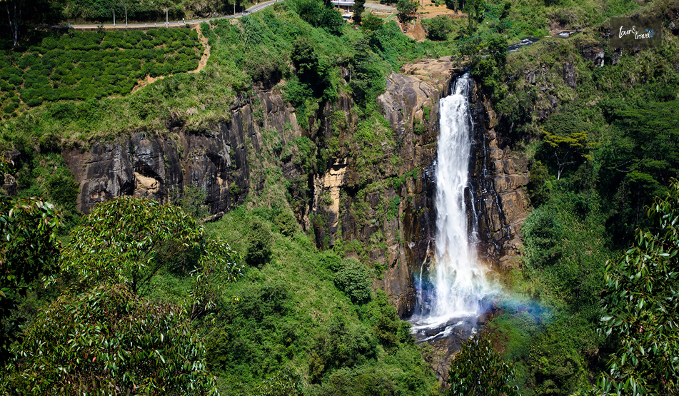
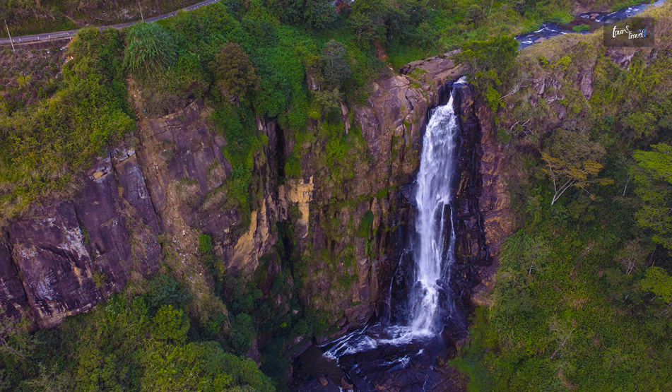
There was a long, narrow ribbon of white water dropping almost straight down into a gorge of tea bushes. 

It was Devon Falls, the “Veil of the Valley” in Sri Lanka’s Tea Country. The name comes from how it falls a long way.  

So, it more than makes up for the lack of width compared to St. Clair’s Waterfall. Here is more about this beautiful waterfall that should be on your Sri Lanka itinerary the next time you visit.  

Some Quick Facts About Devon Falls, Nuwara Eliya  

Details  Information 
Height Around 97 Meters 
Number of Drops  3 Tiers 
River A Tributary of the Kotmale Oya, Part of the Mahaweli River System 
Location 6 KM West of Talawakele, Nuwara Eliya District, Central Province 
Elevation Around 1140 Meters Above Sea Level 
Entry Fee Free and Viewable from Roadside Platform 
Nickname The Veil of the Valley 
Rank 19th Highest Waterfall in Sri Lanka 

Where Is Devon Falls And How To Get There?

Devon Falls, Nuwara Eliya: Know The Timings, Entry Fee, Experience, How To Reach And More

Around 6 kilometers west of Talawakele, Devon Falls is on the A7 highway that connects Colombo to Nuwara Eliya via Hatton. 

This waterfall in the Nuwara Eliya District is at an elevation of around 1140 meters. It is in the heart of the Dimbula tea-growing region.  

From Nuwara Eliya 

The distance between Nuwara Eliya and Devon Waterfall is around 30 kilometers. I took a car from Nuwara Eliya, and it cost me around 3000 LKR.  

You can also take a tuk-tuk, which costs around LKR 2000.  

The road passes directly above the falls. So, even before you reach the viewpoint, you will get your first glimpse of it through the windscreen. 

From Kandy Or Colombo 

If you are traveling from Kandy by road, you will reach Devon Falls within 2 to 2.5 hours via Gampola and Nawalapitiya.  

Furthermore, from Colombo, it is a 4-hour drive on the Avissawella–Hatton route. Since it is a long journey from Colombo, you can pair it with a night in Hatton or Nuwara Eliya rather than a same-day round trip. 

On Foot From The Road 

There are two designated car parks along the A7 that double as observation platforms.  

Both offer a clear view of the three-tiered drop without any walking required.  

If you want a closer look, a short trail leads about a kilometre through the surrounding tea estate toward the base, though the pool itself is not easy to reach. 

The Story Behind The Name Of Devon Falls

Devon Falls, Nuwara Eliya: Know The Timings, Entry Fee, Experience, How To Reach And More

Devon Falls gets its name from Devon, a pioneering English coffee planter.  

His plantation once occupied the land nearby.  

When coffee cultivation collapsed across Sri Lanka’s hill country in the late 19th century due to a leaf-rust blight, tea took its place. 

Today, the falls tumble past neat rows of tea bushes rather than coffee, though the name from that earlier era stuck. 

What I found most memorable about Devon Falls was not just its height, but how sudden it feels.  

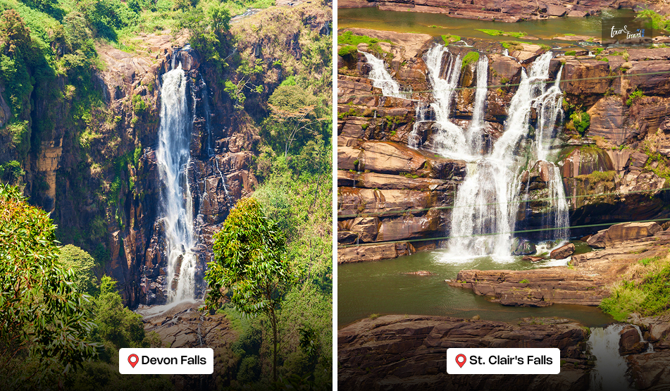
St. Clair’s spreads its water wide and slow. 

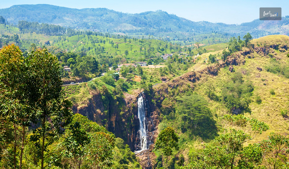
Devon narrows it and lets it drop, almost in a single unbroken curtain through the first two tiers before spreading again near the base.  

Moreover, standing at the main viewpoint opposite the Mlesna Tea Centre, you get the full length of the fall in one frame, framed by steep, green escarpments on both sides. 

What Is The Best Time To Visit Devon Falls? 

Season Months What to Expect 
Wet Season May to September Fuller, more dramatic flow, though mist can obscure the view 
Dry Season December to March Clearer skies, better for photography, lighter flow 
Early Morning Any Season, Before 9 AM Less roadside traffic and softer light on the water 

Pairing Devon Falls With St. Clair’s

Devon Falls, Nuwara Eliya: Know The Timings, Entry Fee, Experience, How To Reach And More

Because the two falls sit only a few kilometres apart on the same road, almost nobody visits just one.  

St. Clair’s is the wider, more famous of the pair, while Devon is the taller and, to my eye, the more dramatic.  

Seeing both in a single stop along the A7 takes less than half a day, which makes this stretch of road one of the most efficient sightseeing detours in the hill country. 

A One-Day Itinerary Around Devon Falls

Devon Falls, Nuwara Eliya: Know The Timings, Entry Fee, Experience, How To Reach And More

Here’s how I’d plan a day trip centred on Devon Falls, starting from Nuwara Eliya or Hatton. 

Time Stop Note  
8:30 AM Depart Nuwara Eliya or Hatton Aim to reach the falls before the midday tour-bus crowds.  
9:30 AM St. Clair’s Falls Roadside viewpoint, about 6 km east of Devon.  
10:30 AM Devon Falls View from the main platform opposite Mlesna Tea Centre.  
11:15 AM Tea estate walk or factory visit Several estates in Dimbula offer short tours.  
12:30 PM Lunch in Talawakele Local rice-and-curry spots along the main road.  
2:00 PM Onward to Hatton or Nuwara Eliya Or continue toward Adam’s Peak if timing allows.  

Practical Tips For A Visit To Devon Falls 

  • Both viewpoints are roadside, so no hiking is required if you just want the classic photo. 
  • Traffic along the A7 can be heavy with tour vans in the late morning. So, an early start helps. 
  • Skip swimming here. The pool is difficult to access, and the currents near the base are not considered safe. 
  • Pack a light jacket. At over 1,100 m elevation, mornings can be genuinely chilly even in the dry season. 

We only stopped for about fifteen minutes at Devon Falls. 

However, it was one of those places that have stayed with me. That long, narrow drop through the tea hills, half-hidden in mist, is hard to shake.

Share on Social Media

Sibashree is a travel, culture, and leisure writer who has been writing since the age of 12 and professionally since 2014. With more than a decade of travel writing experience and journeys across India and several parts of the world, she brings a deeply personal and thoughtful perspective to her work. A student of English Literature and Mass Communication, Sibashree has always viewed travel as more than movement — for her, it has been a way of understanding people, cultures, and herself. Her passion for spiritual exploration has also led her to many unusual and meaningful destinations over the years. Outside of writing, Sibashree enjoys watching European cinema, reading about global politics, and reflecting on the stories hidden within everyday places.

Leave a Reply

Your email address will not be published. Required fields are marked *

title-img Related

READ MORE things to do in galle

What Are The Things To Do In Galle Fort, Sri Lanka? Exploring A UNESCO Heritage Site

BY  Sibashree Mar 24, 2026

Galle has been my ideal dreamy, sepia-toned travel destination located on the southwestern coast of Sri Lanka.  Moreover, the city’s stunningly beautiful old fortified peninsula reaches defiantly out into the Indian Ocean and boasts many crumbling colonial-style buildings, narrow cobblestone streets, and swaying palm trees.  However, the true magic of Galle comes from taking it slowly.  Hi, in today’s blog, I will talk about the things to do in Galle Fort. However, I will begin with why a visit to the Galle Fort is worth it and how to get there.  Why Visit Galle Fort? A UNESCO World Heritage Site And The Fortress That Defied Time “Founded in the 16th century by the Portuguese, Galle reached the height of its development in the 18th century, before the arrival of the British.  It is the best example of a fortified city built by Europeans in South and South-East Asia, showing the interaction between European architectural styles and South Asian traditions.” • UNESCO World Heritage Convention.  The trading post was once impenetrable, and the rampart walls kept the invaders at bay.  However, centuries later, during the 2004 Tsunami, the same stone walls that stood against cannons also protected the people from the ocean.  Thus, the Galle Fort remained intact even though the surrounding coastline was devastated. Today, it stands as a UNESCO World Heritage Site for being a unique example of a fortified city.  How To Reach The Galle Fort? You can easily reach the Galle Fort from Colombo or down the coast.  From Colombo  You can take a train from Colombo Fort, and after a three-hour journey and amazing ocean views, you will reach Galle.  However, currently, this route is being reconstructed. So, you can take a Highway AC bus from the Makumbura Station.  Furthermore, it is a 2-hour journey through the Expressway.  From Mirissa Or Weligama If you’re already beach-hopping the south coast, you can just hop on any local bus headed toward Matara or Galle.  It’s cheap, frequent, and gives you a real taste of local life, and that’s amazing as a follower of TheLowDownUnder Travel philosophy.  Also, from my days in Jaffna to the things to do in Kandy, I have always ditched comfort and the obvious for a more authentic experience.  What Are The Things To Do In Galle Fort, Sri Lanka?  When talking about the things to do in Galle Fort, you have to think beyond the tourist checklist.  Furthermore, Galle is a place of contrasts! You have the rugged, salt-sprayed stone of the ramparts on one hand, and on the other hand, you have the most polished boutique shops.  So, Galle is beyond your usual Instagram photo op.  And one of the best things to do in Galle is to understand how the fortress and the neighborhood have survived empires and natural disasters.  Moreover, in Galle, you become a part of the history as you watch the sunset from an ancient bastion or sip cold beer at a wine bar on a cobblestone street.  Also, you will see an extension of all these in my detailed account of two days in Galle Fort.  Day 1: Getting Lost In The Living Museum Walks, exploring the architecture, culture, and the much hyped sunset experience! These were the things to do in Galle Fort on day one.  Morning: The Rampart Walk Walking is the best way to begin your exploration of Galle Fort. It is small and, therefore, a great destination for pedestrians.  In the morning, I climbed to the top of the stone ramparts and walked the entire way around the edge of the Fort, obtaining a 360-degree view of Galle. I saw the sparkling, turquoise ocean to one side and the red tiled roofs of the original buildings of the town on the other. On your walking tour, look for the famous Galle Clock Tower and the historic Galle Lighthouse, which is probably the most photographed place in all of Sri Lanka.  The whitewashed lighthouse is stunning against the clear blue sky, but I found that the late afternoon light gives it that soft, golden color that makes the palm tree shadows cast perfectly across the grass. Afternoon: Culture And Architecture After you’ve finished exploring the upper level of the walls, it’s time to explore the narrow alleyways of the city.  Throughout the streets, you are going to notice something extremely wonderful. You will see the cultural and ethnic diversity and the same inclusive culture of Sri Lanka, prominent through the iconic Ambuluwawa Tower in Colombo.   In just a matter of blocks, I was able to visit the Dutch Reform Church, All Saints Anglican Church, Meeran Mosque, and Sri Sudharmalaya Buddhist Temple.  All these places serve as a testament to the many different people who have influenced the development of Sri Lanka over many hundreds of years. If the heat of the sun becomes unbearable, I recommend that you check out either the Historical Mansion Museum or the Maritime Museum.  Both of these museums are in beautifully restored colonial structures and provide visitors with great artifacts dating back to Sri Lanka’s colonial period. Evening: The Sunset Ritual When the sun is going down, I suggest that you make your way to the western walls of the fort.  At Flag Rock Bastion, you will find the locals performing their “cliff jumping” tourism attraction.  You will have the opportunity to see how far they will go into the crashing waves.  If you would rather have a quieter spot to watch the sunset, I would recommend that you go to Triton Bastion.  I spent an hour there on the grassy ramparts watching as the sky slowly burned with bright oranges. What a way to see Mother Nature's fireworks show. Day 2: Boutiques, Buffets, And Beaches Day 2 was more relaxed as I shopped, gorged on grand feasts, and explored the beaches.  Morning: The Shopping Mecca Galle is now Sri Lanka's shopping capital. Pedlar Street is the epicenter of the boutique shops, from where you can collect elegant souvenirs.  A few of my personal favorites are in the table below.  Places to Visit for ShoppingThings to BuyStick No BillsVintage-Style PostersThe Tea Room by Evergreen GroupBuy Tea in BulkOld Dutch HospitalThis former colonial hospital is now a chic shopping and dining precinct. It’s the perfect place to grab a coffee and browse. Lunch: A Local Feast After the spicy food in Jaffna, the food in Gelle was comforting. So, trying the Coconut Sambal is one of the best things to do in Galle.  You will get the curries with chicken and vegan-friendly options here. Also, to beat the midday Sun, have some homemade ginger beer or treat yourself to a scoop at Isle of Gelato.  Moreover, don’t forget to try the cashew caramel at Isle of Gelato.  Afternoon: Beyond The Walls As the Sun starts getting softer, you can explore the surrounding coast. Also, if you want to extend your coastal hunt, head to Dewata Beach.  Here, you will find many beginners and professionals surfing the waves.  Furthermore, if you want to just relax, take a tuk-tuk ride to the Jungle Beach in Unawatuna. It is a small sandy cove with lush greenery. 
READ MORE Nilaveli Beach

Nilaveli Beach: Four Kilometers Of Sand And Not Much Else

BY  Sibashree Jul 27, 2026

There is a particular kind of quiet that settles over a beach town when you cannot think of a proper definition for it.  Nilaveli Beach has it. Still, it is one of the 13 beaches in Sri Lanka that Lonely Planet has highlighted as the best coastal escapes in January 2026.  This recognition once again solidifies the position of Sri Lanka as an international tropical destination.  Do you want to know more about Nilaveli Beach? Here, I will discuss my first experience in this coastal town, how to reach there, and how I spent my time here.  My First Impression Of Nilaveli Beach  I arrived at Nilaveli Beach in the late afternoon. The beach looked magical with the golden light.  Also, instead of traffic horns or music, the rhythmic slap of fishermen pulling in nets a few hundred meters down the shore was the first sound to reach my ears.  This sound had set the right tone for all the experiences that followed at Nilaveli Beach.  How I Reached Nilaveli Beach? Nilaveli is on the northeastern coast of Sri Lanka. It is also 16 kilometers north of Trincomalee.  Furthermore, the distance between Nilaveli and Colombo is around 264 kilometers. So, it is a journey of approximately 6 hours by road.  However, you can also fly to the small domestic airport of Trincomalee. Tuk-tuks and local buses run the short hop between Trincomalee town and Nilaveli itself without much fuss. Nevertheless, I made the trip overland after finishing up in Kalpitiya on the northwest coast.  I cut across through the interior, and I would recommend that route if you want to enjoy a longer east-coast itinerary.  Taking the route also puts you within easy striking distance of Mannar if you are willing to backtrack a little.  Nilaveli Beach: It Has An Older RĂ©sumĂ© Than You Can Guess Nilaveli is different from many other beaches on the east coast as it has been in the tourism business since the 1970s.  Then, it had a couple of beachfront hotels, and those were quite popular among the tourists making their way to this part of the country.  However, that tourism scene got interrupted by the rampage of the Civil War for two decades.  The Civil War shaped so much of what I saw further north in Kilinochchi and Mullaitivu. However, it emptied the coastline here.  After the war ended in 2009, Nilaveli Beach has been very cautious in its attempt to return to form.  It did not have the resort boom like Pasikudah further south. However, that has been a blessing in disguise as fewer beach clubs have ensured longer silences and more space.  What Is So Magical About Nilaveli?  The Nilaveli Beach itself is the main attraction with pale and soft sand running for kilometers.  Furthermore, the gentle shallow gradient made it safe for swimming, and it offered enough space. So, even after a decent crowd strength, it did not feel crowded.  I walked a good stretch of it one morning before the heat set in and passed maybe a dozen people the entire way. You can just sit offshore and unwind. However, I chose to explore more.  What I Did At Nilaveli? I took a boat ride to the Pigeon Island National Park, one of the few marine national parks in the country.  It has an extensive coral reef, the home to over 100 species of corals, 300 species of fish, turtles, and blacktip reef sharks.   Snorkeling At Nilaveli Beach  I booked a morning snorkeling trip and spent a couple of hours drifting over coral gardens, watching for the blacktip reef sharks the island is known for. They were small and shy! I also spotted some green turtles.  Here, let me share some important details and how we can be responsible in our behavior here.  The reef is not as pristine as it used to be decades ago. After the 2009 tsunami impact and to minimize the traffic impact, the government has capped daily numbers and started rehabilitation work. So, if you have snorkeling plans, especially in the peak seasons from May to October, you need to book your slot in advance. A Trip To Trincomalee, Just Down The Road  I allocated one day for myself away from the sand to explore Trincomalee proper.  Fort Frederick was built by the Portuguese and later expanded by the Dutch and British. It sits on a headland with genuinely dramatic views out over the harbor. The harbor is further one of the finest in the world. Inside the fort grounds, the Koneshwaram Temple was the highlight for me. Furthermore, you can visit the Kanniya hot springs and the Uppuveli Beach too. Nilaveli Beach wins with its honesty, and the reef here is really vibrant.  Pasikudah is Sri Lanka's east coast dressed up for a resort brochure. Nilaveli is a humble coastal hub with its history and marine diversity.

READ MORE Mullaitivu

Mullaitivu Tourist Places And The Coastline That Taught Me How Silence Speaks

BY  Sibashree Jul 22, 2026

My trip to Sri Lanka crossed many dramatic turns, especially in the Northern part of the country.  With Vavuniya feeling like a crossroads rather than a stopover and Mannar being a high point where the wind never stops, the next stop was Mullaitivu.  Mullaitivu was a name that I had only read about in the news archives.  Mullaitivu is even in the news today as the people of Keppapilavu have been protesting for days now for the return of their ancestral lands.  Thurairasa Ravikaran and Sivagnanam Shritharan, two Tamil parliamentarians, have shown their support and solidarity to this protest.  Nevertheless, while Trincomalee beaches and the rich culture of Jaffna dominate the conversations about Northern Sri Lanka, Mullaitivu surfaced as a place talking about the past.  In this article, I will talk about my two days in Mullaitivu, from the drive in to the lagoon that ended a war, and why I think this coastline deserves more than a passing mention on a map. Why Mullaitivu Almost Stayed Off My List The day I spent at Vavuniya, the guesthouse caretaker there, a soft-spoken man named Selvam, was the one who first brought up Mullaitivu. About Mullaitivu, he mentioned,  “The beaches were empty, the lagoon was calm, and the town had not yet learned how to perform for tourists.” This stirred me, as most travel forums I had checked mentioned Mullaitivu as a former war zone with a nice coastline and not much infrastructure. While this is not false, this is only a fragmented picture of Mullaitivu. How I Reached Mullaitivu From Vavuniya, I took A34 to reach Mullaitivu. It was a distance of around 54 kilometers, and I reached within an hour and a half.  The road narrowed past Puthukkudiyiruppu, cutting through scrubland, paddy fields, and the occasional stretch of forest before the land flattens out toward the coast. How Mullaitivu Felt At First Sight?  Mullaitivu was once a small fishing harbor.  It was a small fishing harbor and a stop for sailing vessels moving goods between Colombo and Jaffna in the early twentieth century.  Today, it also remains a fishing town, unbothered and unhurried by outsiders.  As I entered the town, my driver, Ravi, pointed out the old lighthouse. It was built in 1896, and it has lost its original iron frame.  So, when you visit the lighthouse today, you can only find a faded signboard.  Nevertheless, I spent my first evening walking along Mullaitivu Beach.  Fishing boats had gathered there, forming neat rows, and the nets were drying on the sand.  Also, it was most delightful to find children playing cricket on the sand with a tennis ball.  Being from the country where cricket is a religion, I joined them. We bonded big time talking over big names such as Kumar Sangakkara and Kusal Mendis.  A few meters away from them, an elderly woman was mending a fishing net.  It felt like a scene from a Sanjeewa Pushpakumara movie. Like his films, Flying Fish and The Venishing, it was like a scene depicting the raw portrayal of survival.  What Are The Places To Visit In Mullaitivu?  I was not prepared for the amount of Civil War history Mullaitivu offered me.  Also, the birds and the sanctuary where the beach and lagoon meet allowed me to unwind with so many things going on in my head about life during and after the Civil War in Sri Lanka.  Nanthikadal Lagoon: Where The War Ended At a glance, the Nanthikadal Lagoon looks like a shallow, sand-fringed body of water. It is on the northeastern edge of the district. Small rivers feed it, and it finally opens into the Indian Ocean.  When I reached the lagoon, I found some egrets standing motionless in the shallows. Then, a kingfisher dropped into the water and came up empty. Ravi then took me to an old man, a local school teacher called Rajan. He narrated the entire story of the Nanthikadal Lagoon to me.  What Happened At Nanthikadal Lagoon  The 26-year Civil War of Sri Lanka ended at Nanthikadal Lagoon in May 2009.  Here, the government forces cornered the last LTTE fighters. The group's leader, Velupillai Prabhakaran, was also killed.  In the weeks before that, civilians had been pushed into a shrinking strip of land along this same lagoon. They were between the fighting lines. In a report published on 17th January 2009, The Guardian wrote,  “International concern is intensifying over the fate of around 350,000 civilians trapped in a rapidly shrinking rebel-controlled pocket of land in Sri Lanka's north east, as the military steps up its campaign to end the civil war by crushing the Tamil Tiger forces. There is no specific count of the number of human casualties in these final months. A 2011 UN Panel of Experts report stated that credible sources estimated as many as 40,000 civilian deaths. Another report, published by The Times (UK) on 29th May 2009 based on confidential UN documents the paper obtained, reported that civilian deaths in the no-fire zone rose sharply from late April. The deaths averaged around 1,000 killed per day until May 19, 2009. Thus, it had put the total civilian death toll at over 20,000. (Source: Al Jazeera).  The Sri Lankan Government has shown a much lower figure.   However, in the UN Rights Council: Act on Sri Lanka Report published on 13th September 2011, Brad Adams, the Asia director at Human Rights Watch, mentioned,  “When a UN Panel of Experts report concludes up to 40,000 civilians died amid war crimes, the Human Rights Council should feel compelled to act. The council should order a full international investigation – anything less would be a shameful abdication of responsibility.” How Nanthikadal Lagoon Looks Back At Those Days Every Year Tamil families gather at Mullivaikkal, close to the lagoon, on 19th May every year to remember relatives lost in the final days.  They light lamps and plant coconut saplings in their memory.  Standing at the water's edge, with fishermen casting nets a short distance away, I found it hard to reconcile the stillness in front of me with what this ground had witnessed. The Victory Monument, The Museum, And The Submarines The Puthukkudiyiruppu Victory Monument was on the Paranthan-Mullaitivu road, which was a short drive from the lagoon.  It was unveiled in 2019, and it depicts a soldier carrying the national flag.  Furthermore, the surrounding pond and lilies represent the ocean around the island and the nation itself.  An adjoining war museum displays weapons, vehicles, and vessels used during the conflict's final phase. Entry to the museum was free, and it remains open from 8 AM to 5 PM.  Also nearby, there were rusted hulls, and it was the site where the government troops discovered an abandoned Sea Tiger boatyard in 2009.  It is where the LTTE's naval wing used to build improvised submarines and semi-submersible craft.  I want to be honest about something here. This is a site that different communities in Sri Lanka read very differently, and I do not think a two-day visit qualifies anyone to settle that.  What I can say is that visiting both the lagoon and the monument on the same day gave me a fuller, more uncomfortable picture than either would have alone. The Kokkilai Lagoon:  Where The Coastline Turns Peaceful Again On the second afternoon, I drove out to Kokkilai Lagoon.  It was a wetland sanctuary around 25 kilometers southeast of town.  It has been a protected bird sanctuary since 1951, and I could spot pelicans, herons, and occasional flamingos moving along the shallows.  The crowd of birdwatchers was small, and the overall ambiance was quiet.  Chundikulam Further along the coast, Chundikulam allowed me to relax. It was a sanctuary with no visitors.  I quietly cherished the view of the beach and lagoon blurring into one uninterrupted stretch of sand and water. Coming back from Chundikulam, I had some spicy crab curry and rice at a roadside stall. It was similar to what I had in Jaffna, but it tasted even better.  Ravi said, “It was the only reason to end the day here.”  My Two Days In Mullaitivu: The Itinerary  Day TimeActivities/Places to VisitDay 1MorningDrive from Vavuniya via the A34MiddayCheck-in and Walk through Mullaitivu TownAfternoonNanthikadal Lagoon and the CausewayEveningMullaitivu Beach at SunsetDay 2MorningPuthukkudiyiruppu Victory Monument and War MuseumMiddaySea Tiger Submarine YardAfternoonKokkilai Lagoon BirdwatchingEveningChundikulam Coastline and Seafood Dinner Mullaitivu: A Quiet Place That Asks You To Listen  Away from the grandeur of Kandy and Colombo, Mullaitivu is a place that simply exists. It tells the stories of human survival, and it is still recovering and fishing despite the stains and the lives lost in the Civil War.  So, if you are already tracing the north of Sri Lanka through Vavuniya, Kilinochchi, or Mannar, I would not leave Mullaitivu off the route.  Just go with the understanding that this is not a beach add-on. It is a place that holds two very different stories at once, and it does not owe you a tidy conclusion to either.