


 Related
Is Seattle Safe for a Tourist: My Experience!
BY sagnika Mar 11, 2025
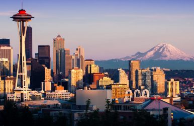
Are you planning a trip to Seattle? It is a major city and there is both a possibility of experiencing beautiful places and also being a victim of scams. So, somewhere it is your responsibility to research before you visit the place. It is one of the best places to travel solo female in US! Simultaneously, when you are planning to visit Seattle, researching different types of scams will help you become more aware. As a solo traveler, it is important to focus on soaking up the culture of the place. Wander around these beautiful places, drink coffee, and go on a hike across glorious mountains and others! Let me share with you some safety tips for navigating the streets, eating the best street food, exploring the wild and exotic outdoors thus, having diverse experiences. Is Seattle Safe for a Tourist: My Experience! One of the most dangerous neighborhoods in Seattle, areas around Pike Place Market at night are not safe for you. You might also skip going to the 12th and Jackson and Aurora Avenue if you are traveling alone or at night. However, the question is Seattle safe is obviously a question for a tourist! But try to think from the perspective of a local person, and connect with the places, events, and festivities. Just to stay safe, you can keep your laptop, documents, and other electronic devices with you at all times. Apart from implementing safety tips, you also need to enjoy the place when you are visiting. Seattle as a place is beautiful and has a lot to offer so you should be aware of your surroundings! This is one of the best places to travel with kids too! Safety Tips When You Visit Seattle The rush hours in Seattle are from 7 to 9 AM and 4 to 6 PM so, if you want to drive, you need to remember this. Furthermore, there is Google Maps to help you navigate the roads and avoid congestion. I would also suggest you avoid isolated and dark bus stops if you are traveling at night! So, this is the perfect place for you if you are asking the question, is Seattle safe? Let me fill you in with the safety tips mostly related to what to do when you first arrive in Seattle. Property crime Whenever you visit a big city, you will see property crime happen especially because you get to see neighborhoods that are quite high maintenance. There are some common scams when it comes to properties especially if you book an Airbnb. It is better if you constantly stay in contact with the owner. Additionally, if there is a caretaker, you must be cautious in the beginning especially when it comes to your electronics, luggage, and others. Pickpockets Anywhere you go in the world, pickpockets will be there. They are everywhere because poverty is everywhere and of course, they are struggling. Often as a tourist, when you look different and behave differently, pickpockets identify you as an easy target. It is better if you try to blend in as a local, trying to mingle well. There is also an application, Bounce, which you can use to keep your luggage, especially if you are traveling alone and have already checked out of your accommodations. Avoid keeping your mobile phones, cameras, and wallets in your hand all the time. It is again something that makes you an easy target. Also, people with the intention of fraud might chat with you a lot, a way of distracting you. Be careful of your surroundings! Gold Jewelry scam At times, you might find someone telling you a sob story and engaging you in a way where you might end up losing money. They ask for money, even request you to give your gold ring or jewelry, if you are wearing any. Initially, you might feel like you are helping someone, or it is a good deal to offer something to them. However, later you realize it is a scam, and they can easily sell your jewelry at a pawn shop and earn money. Safe Accommodations Options in Seattle Several accommodation options in Seattle are quite safe. When visiting Seattle, you can go across the entire city because it is safe. However, there are issues especially if you are traveling alone or at night. Let me share with you some of the safest neighborhoods in Seattle. I am sure you can decide which will be best for you, especially if you are covering various places in Seattle, locations, and events. Blue Ridge A tranquil neighborhood, Blue Ridge is quite close to Golden Gardens Park. It is mostly residential but what is more beautiful is the beautiful views and hiking trails of Puget Sound. You can book Hotel Ballard with a rooftop pavilion, which is quite luxurious, in addition to an athletic club. It will cost you around $250 per night hence, I would say you must book soon. Hawthorne Hills Another upscale neighborhood, Hawthorne Hills is a perfect place if you are looking for a peaceful vibe. The University of Washington is quite close to this area offering you quite a scenic view of Lake Washington. Furthermore, you can also check out the Cascade Mountains, another amazing view. Additionally, the place is residential so you can make a booking at the University Inn – A Stayinpineapple Hotel. It will cost you around $160 for a night at the hotel. If you are trying to live on a budget and experience the University style, book the dorm-style rooms with a fun pineapple theme. What's more, you can also use the pool! Places You Must Visit in Seattle With exotic locations and unique geography, Seattle offers you one of the coolest places to visit. Let's not forget that it is also quite a safe place for tourists. Why don’t I share with you some of the best ways to get around and enjoy your vacation? First Hill and South Lake Union are two neighborhoods that are connected by streetcars. Additionally, you can also use public transport like taxis, ferries and buses which will help you move easily around. Furthermore, you can also use the ORCA card and the Transit GO Ticket app if you are looking for easy payments. Another way to maintain real-time schedules is to download the OneBusAway app. You know you can also go visit Seattle while booking on one of the best cruises from Florida! Cultural Practices that You Might Want to Know If you follow some of these cultural practices, I feel you will not feel or look completely out of place when in Seattle. You can try some of these cultural practices that will help you blend in with the locals in Seattle. Most of the locals seem very friendly especially when they initially meet someone new. However, they will not form any deeper connections with people they have met recently. Called the “Seattle Freeze”, you should be careful and don’t take it to heart when this switch happens. I would say you shouldn’t form deeper connections in the beginning or even expect them to become close buds. If you are a coffee lover, this is the perfect place for you to visit, it is an art form here! Did you know Starbucks originated in Seattle? A jacket is a must when you visit Seattle because it can get cold really fast! The weather in Seattle is unpredictable that way so you can dress however you like but try to have a jacket with you at all times. In Case of an Emergency... When asking the question, is Seattle safe, I would say, it feels that way for the locals. However, as a tourist, I would say you should stay a little careful and aware. Not just in Seattle, you can fall prey to pickpockets or a scam anywhere in the world if you are a stranger to that place. Following the tips we have shared regarding how you can navigate the place; you should also know a bit about the cultural practices. Comment below to let us know do you feel safe when you are traveling to Seattle after you read this article. Also read Top 10 Most Popular Paraguay Food That You Must Try. Top 13+ Famous Wonders Of India That You Must Visit.