


 Related
Pokagon State Park Camping | The Best Year-Round Camping Experience At Pokagon State Park
BY Sibashree Jan 27, 2025
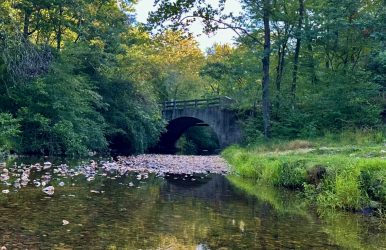
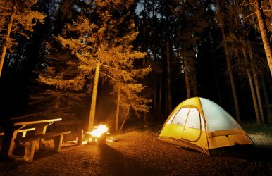
The Pokagon State Park in Indiana is famous for deer hunting. However, things went haywire on 7th July 2024 when the police received a phone call from the park regarding the shooting at the park. Shots were fired near the toboggan run, and at least three people were injured. Nevertheless, despite Pokagon State Park being in the news for the wrong reasons, we cannot deny its charm as a year-round camping ground. With its inns and cabins and endless activities to do in the park, it is even a popular staycation spot for the people of Indiana. So, are you also ready for camping and fun at Pokagon State Park? This Tour and Travel guide is here to help you! However, let’s know this state park at a glance. Pokagon State Park At A Glance | Things You Need To Do Pokagon State Park’s location is around 10000-15000 years old. The Wisconsin glacier has been transformed into this park thanks to nature forces and factors. Further, it has more lakes than any other Indiana state park today. All the lakes here are formed after the meltdown of glaciers, and Lake James, with an area of 1000 acres, is the largest among them. Moreover, it is home to over 200 species of birds and diverse ecosystems. In addition, the land of the state park belonged to the Potawatomi tribe. After procuring the land from them, it was named Pokagon, after the tribe chief. The table below has more details you need to know about the park. Year Of Establishment1927EcosystemsMarshesLakesSwampsFensPine GrovesMeadowlandsOld FieldsDeciduous WoodlandsEntry Fee$7.00 (noncommercial vehicles with Indiana number plates)$9.00 (noncommercial vehicles with non-Indiana number plates)$2:00 for 5 years and older. $1:00 Programming Fees$50 Annual Entrance Permit for Residents$70 Annual Entrance Permit for Non-Residents$25 Golden Hoosier PassportBest Time To VisitWinterLocation450 Lane, 100 Lake JamesAngola, IndianaHours Open7 AM to 11 PMContact NumbersPokagon State Park Office: (260) 833-2012Nature Center: (260) 833-3506 Pokagon State Park has pleasant weather conditions throughout the year. During the summer months, the highest temperature hovers around 80 degrees F. Further, in winter, you can expect a temperature between 1-18 degrees F. Pokagon State Park Camping | Get Ready For Year-Round Attractions Indiana people love outdoor time, and Pokagon State Park best matches their interests. It has abundant nature, with various ecosystems and over 200 species of birds. Further, the lakes in the park allow you to enjoy an immersive time there. On the other hand, it has all modern-day amenities. Moreover, irrespective of the visiting season, the campers always have some fun activities to engage in. Things To Do At Pokagon State ParkBoatingFishingHikingHorse RidingPicnicWinter SportsToboggan Run For example, if you are at the park in summer, you can swim in the lakes and cool off. You can even visit the bathhouse. Further, in winter, you can enjoy toboggan runs, cross-country skiing, and sledding, with the entire park transformed into a snowy wonderland. Moreover, the park has the best wildflowers in spring and the fiery reds of the autumn foliage are magical here. So, are you all set for camping at Pokagon State Park? Let’s discuss the camping grounds and facilities. Electric Sites (Class A) At Pokagon State Park Camping Nightly Rate: $23 (Sunday-Wednesday), $30 (Thursday to Saturday), $33 (Holiday Weekends) Campgrounds 1,3, 4, and 5 of the state national park have electric or Class A camping sites. Among them, a few sites in Campground 3 have ADA-accessible 366, 368, 374, and 376 camping sites. These sites have electrical hookups and other amenities here, including drinking water, showers, restrooms, parking spurs, picnic tables, and fire rings. Non-Electric Sites (Class B) At Pokagon State Park Camping Nightly Rate: $16 (Sunday-Wednesday), $19 (Thursday to Saturday), $22 (Holiday Weekends) At the Campground 2 of the state park, you will find 73 non-electric campsites. These are equipped with fire rings, parking spurs, restrooms, showers, and drinking water facilities. Youth Tent Area Campsites Nightly Rate: $20 ($2 Each for 10 People, Additional $2 Per Person) The Youth Tent Area has 5 campsites, and they only allow tents. Here, the campers should be below 21 years old, and there can be 10 members in a group, guided by an adult leader. Moreover, these campsites have pit toilets, fire rings, and picnic tables. Campground 5 and Spring Shelter will also have a drinking water supply. Group Camp Site Nightly Rate: $480 This group campsite is ADA-accessible. It can accommodate a total of 78 people in 12 cabins. There is another counselor cabin where 14 people can stay. Moreover, the two bunkhouses at Pokagon State Park are ideal for 36 people (18 each). Other amenities in the park include: A commercial-style kitchen Basketball court Dining hall Craft room Picnic tables Volleyball court Charcoal grills Seasonal dock Parking facility for 21 vehicles In addition, the Group Camp Site offers the most amazing lake view. Camp Store Summer Season Hours: Monday-Saturday (9 AM to 9 PM) and Sunday (11 AM to 7 PM) You will find the camp store close to the Campground Gatehouse of the state park. The camp store remains open seasonally. If you are camping in the park, you can collect food, drinks, wood, ice, and other essentials from the camp store. You can also collect souvenirs from here. Pokagon State Park | Cabins, Hotels And Inns If you are not in parking at Pokagon State Park, you can stay at the hotels, inns, and cabins here. The Potawatomi Inn is the best among them and it has a whiff of history in its name. This inn has 126 hotel rooms, 8 cabins, and 4 cabin suites. Further, you will love the Lakeview Restaurant or the Sauna Bath Corner here. You can contact The Potawatomi Inn at 1-877-768-2928 for booking. Moreover, for a rustic experience, you can plan a stay at the historic Pokagon State Park cabins. Eight of the cabins are remodeled and they come with proper HVAC systems. In addition, Ramada by Wyndham Angola/Fremont Area (Contact No: +1 260-624-4402) and Hotel Quality Inn Fremont (Contact No: (419) 332-0601) are some hotels near the state park. Also read Top 10 Most Popular Paraguay Food That You Must Try. Top 13+ Famous Wonders Of India That You Must Visit. Top Tips For Motorbike Rental In Phuket – A Guide To Exploring The Island On Two Wheels.