Are you searching for the best national parks in Oregon? If the answer to this question is a YES, then you have reached the right place!
The state of Oregon, which is blessed with magnificent scenery, nature, and landscapes, is situated in the US’s Pacific Northwest. It has a wide range of attractions to offer. There are stunning mountains and picturesque shoreline to lush woods, vast deserts, and intriguing canyons.
Oregon is a destination for outdoor enthusiasts due to its remarkable variety of landscapes. It has plenty of amazing hiking, camping, and animal viewing to be experienced anywhere you go.
In this article, I will be talking about one such natural wonder— the national parks in Oregon! S, if that is something that you are searching for, there is one thing you need to do. And that is to keep reading this blog till the end…
Top 10 National Parks In Oregon That You Must Visit!
Despite having just one national park, Oregon is not short on beautiful landscapes. The state is full of natural beauties, including a fossil-rich desert, gorges, untamed rivers, and 360 miles of public coastline.
In this article, I will be focusing on the top ten national parks of Oregon that you must visit. So, if that is something that you have been searching for, then you will find this blog to be of great help!
Keep reading this article till the end to learn more…
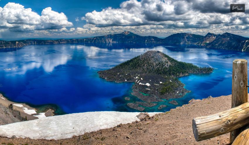
1. Crater Lake National Park
As one of the deepest and clearest lakes in the world, Crater Lake National Park in western Oregon is well-known today. But 7,700 years ago, the eruption of Mount Mazama, which formed Crater Lake, is probably one of the largest geologic catastrophes ever.
After Mount Mazama erupted, it fell, leaving a crater more than 1,200 meters deep. It measured 8 kilometers north to south and 10 kilometers east to west. The crater subsequently filled with rain and snowmelt.
The Crater Lake is awe-inspiring, and that is why it is the first one on the list of the best and most visited national parks in Oregon. Native Americans saw it form nearly 7,700 years ago when a powerful eruption caused a lofty mountain to collapse. Its purity and popularity as the deepest lake in the United States. It is also one of the most pristine lakes on the planet, nourished by snow and rain, astounds scientists. Photographers, artists, and tourists love the breathtaking location and crystal-clear water above the Cascade Mountain Range.
2. California National Historic Trail
The California National Historic Trail, is situated geographically near a number of towns and states. With state map illustrations and driving instructions, modern auto tour routes closely resemble the historic road(s). It offers opportunities to find the trail’s remains and important resources. Insight into life on the trail is provided by fascinating tales. It recorded incidents of immigrants, businesspeople, missionaries, and fortune seekers.
During the 1840s and 1850s, more than 250,000 people made the largest mass migration in American history. They moved to the gold fields and fertile farmlands of California. The more than 5,000-mile-long California National Historic Trail passes through parts of ten states. Over 1,000 miles of ruts and tracks left by travelers and their overland wagons allow you to walk through history.
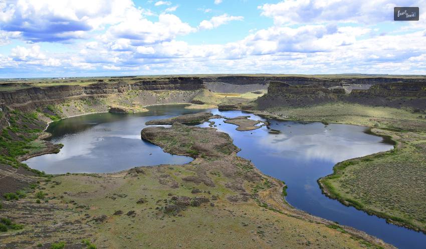
3. Ice Age Floods National Geologic Trail
Glacial Lake Missoula, a 3,000 square-mile body of water encircling Missoula, Montana, is the result of an ice dam in northern Idaho at the conclusion of the last Ice Age, between 18,000 and 15,000 years ago. Floodwaters burst open when the dam broke, traveling across Washington, Oregon, and the Columbia River before reaching the Pacific Ocean. The Ice Age Floods affected the people, and the terrain of the Pacific Northwest, profoundly.
The majority of geologists thought that glaciers and streams slowly eroded rock formations to create Washington’s Channelled Scabland. Geologist J Harlen Bretz postulated that cataclysmic floods were responsible for the formation of the Channelled Scabland after finding geologic data that contradicted this theory.
Bretz’s theory was initially mocked, but it was later proven correct thanks to new technology like satellite photography. By the 1970s, everyone agreed that the Ice Age Floods were to blame for the ravaged terrain of the northwest United States.
Today, the terrain is littered with remnants of these Ice Age Floods, including massive basalt coulees ND massive dry falls. It also has big boulders that have traveled hundreds of miles, high water lines, and tremendous current ripples. The Ice Age Floods National Geologic Trail includes spectacular examples of cataclysmic flood geology, breathtaking landscapes, and locations for scientific study.
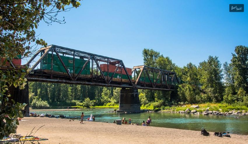
4. Lewis And Clark National Historical Park
The Lewis and Clark National Historical Park is tucked away in northwest Oregon, close to the Washington state line, just south of Astoria. It honors the remarkable accomplishments of the well-known couple who traveled the United States by bearing their names.
It was at this picturesque location that Lewis and Clark finally brought their expedition to a close. They set up camp for the winter of 1805, with everything from thick rainforest and magnificent coastline panoramas to portions of the Columbia River and Pacific Coast.
A copy of Fort Clatsop and a visitors center are located in the historical park. You can learn all about their journey here. They both contain intriguing artifacts and displays. Its woodlands also offer some fantastic hiking opportunities, and kayaking, fishing, and wildlife viewing are all very popular.
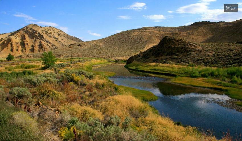
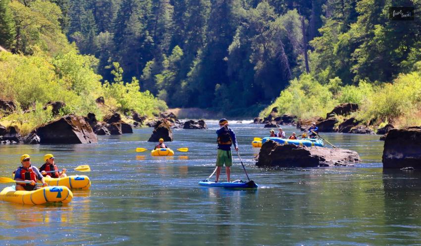
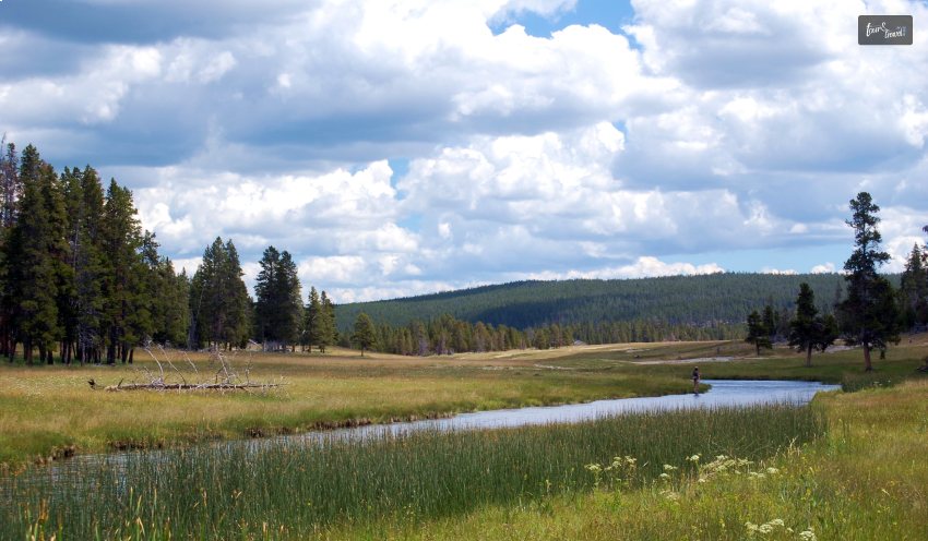
5. Valley Of The Rogue River State Park
The Rogue River in Oregon is appropriately called and is the next one on the list of national parks in Oregon. It flows through the state’s southwest and is famous for its untamed rapids, untamed beauty, and legendary salmon runs.
The thirty-five-mile stretch that goes downstream from the Grants Pass is one of the best whitewater runs in the nation. Visitors can also explore the Rogue on foot along the Rogue River National recreation path. It follows the river for more than 80 miles.
With a rafting-supported backpacking trip, you may explore the entirety of Rogue in one fell swoop. It is available from many local outfitters. Rafts carry camping gear downstream and give weary hikers the chance to float down the river.
The Rogue River is famous for its salmon, steelhead, and rainbow trout fishing, and a number of dams have been demolished recently to reopen fish migratory routes.
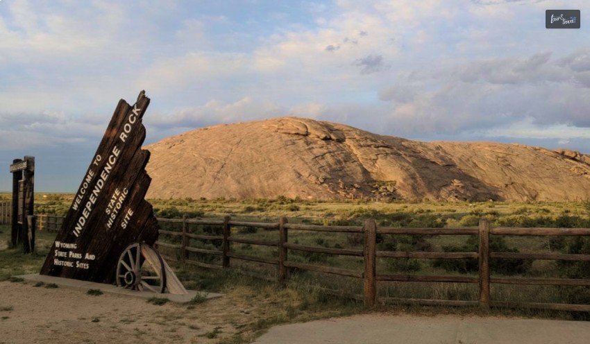
6. Oregon National Historic Trail
If you were an immigrant heading to Oregon, would the promises of luscious farmlands and a fresh start tempt you to leave your home and trek for days? The Oregon National Historic Trail, which spans more than 2,000 miles across six states, still bears witness to the sacrifices, tribulations, and victories of early American settlers.
A number of African Americans traveled to Oregon as pioneers. Some did so voluntarily as free people, while others faced coercion as slaves. Between the 1840s and 1860s, hundreds of people certainly made it to Oregon.
With state map illustrations and driving instructions, modern auto tour routes closely resemble or follow the historical road(s), offering opportunities to find the trail’s remains and important resources.
Thousands of wagon wheels and hooves moving west ran over the land, pounding the surface. Known as waggon ruts, their remnants can take a variety of forms depending on the kind of soil and the long-term impacts of water erosion. Visiting a trail rut and traveling back in time is one of the best ways to experience the Oregon Trail. Fortunately, you may still find places today where you can have that experience.
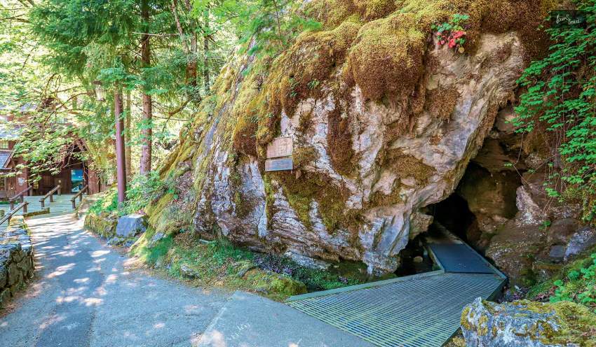
7. Oregon Caves National Monument And Preserve
The magnificent “Marble Halls of Oregon” are tucked away in the Siskiyou Mountains. The Oregon Caves National Monument and Preserve is a well-liked and remarkable tourist destination that is located in the southwest of the state, close to the California border.
The lovely cave complex, which was formed millions of years ago, glitters and shines before your eyes, with spectacular formations and exquisite stalactites and stalagmites everywhere you turn. Exploring the caverns’ vast halls, fantastic passages, and dark depths while on tour is an excellent way to learn more about their history and geology.
Even while the unusual underground tunnels are the main draw, the surface is just as fascinating, with sparkling rivers and streams meandering through the forest. The gorgeous preserve is the perfect location for nature enthusiasts, offering hiking, hunting, and animal viewing.
8. Nez Perce National Historic Trail
The Nimiipuu (Nez Perce) people have lived in the prairies, valleys, plateaus, and mountains of the inland northwest since the beginning of time. They were incredibly tenacious, surviving the American colonization and adapting to a new world.
A non-traditional national park, Nez Perce National Historical Park is made up of 38 sites that collectively depict the tale of the Nimiipuu (Nez Perce). These sites are dispersed throughout a large portion of the Nimiipuu people’s modern-day homelands in Idaho, Montana, Oregon, and Washington.
The visitor centers in Lapwai, Idaho, the Big Hole National Battlefield near Wisdom, Montana, and the Bear Paw Battlefield near Chinook, Montana, all have staff on hand. It might require a significant amount of time and travel over many hundreds of miles to see all the park’s attractions.
There are 38 locations in the Nez Perce National Historical Park that are significant to the history and culture of the Nimiipuu. Examine these locations. Find out their tales. There is just so much to do here!
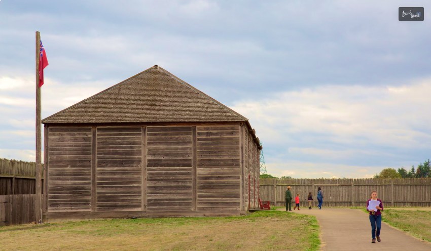
9. Fort Vancouver National Historic Site
This park has a rich cultural history and is on the north bank of the Columbia River, in view of snow-capped mountain peaks and a bustling urban environment. Four distinct locations share history, ranging from a frontier fur trade post to a significant military legacy, the wonder of flying, and the beginnings of the American Pacific Northwest. Learn about tales of change, settling, conflict, and community.
The enormous collection of archaeological artifacts, historical artifacts, and archival records kept at Fort Vancouver National Historic Site helps to tell the site’s tales. Native Americans from before and after European contact, the Hudson’s Bay Company fur trade, the United States Army, early military and civilian aviation at Pearson Field, and the Kaiser Shipyards are all represented in the museum collection.
In the midst of the bustling City of Vancouver, the Fort Vancouver National Historic Site is a haven of natural beauty and history. This National Historic Site includes a number of dog-friendly routes as well as a summer Bark Ranger programme for tourists and their canines. On the grounds of Fort Vancouver National Historic Site, have a picnic. The park has a number of picnic sites that are accessible from sunrise to dusk.
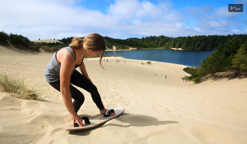
10. Oregon Dunes National Recreation Area
The last one on the list of the best national parks in Oregon is the Oregon Dunes National Recreation Area. The vast majority of Oregon’s coastline is stunningly rocky and rugged, but this 40-mile stretch of beach between the Coos and Siuslaw rivers is home to the continent’s greatest stretch of coastal sand dunes.
Windswept dunes that rise 150 meters above sea level here are perfect for hiking, whale viewing, riding horses, and off-roading. Both developed campsites and undeveloped locations along the Siltcoos river offer camping options.
Both developed campsites and undeveloped locations along the Siltcoos river offer camping options. Reservations are advised for the state parks of Umpqua Lighthouse to the south and Jessie M. Honeyman to the north, which both provide additional sites.
The quieter regions with just foot traffic are kept apart from the areas for motorized off-highway vehicles by Oregon Dunes admirably. The largest off-road area, if you’re into it, extends between Spinreel Campground and Horsfall Road.
While exploring the dunes on foot, by horseback, or in a dune buggy is a lot of fun, the recreation area also offers a number of campsites for visitors to use. Fishing and canoeing are also very popular here. With so much to see and do, it’s a wonderful spot to travel to.
Wrapping It Up!
In case you were searching for the best national parks in Oregon, I hope that this article has been of help to you. If there are any other queries related to the same, feel free to let me know. All that you need to do is scroll down till you reach the bottom of the page. Then leave your comments and queries in the box below.
Ankita Tripathy loves to write about food and the Hallyu Wave in particular. During her free time, she enjoys looking at the sky or reading books while sipping a cup of hot coffee. Her favourite niches are food, music, lifestyle, travel, and Korean Pop music and drama.
Setting out on a road trip is unquestionably thrilling as well as liberating. Nothing compares to taking to the open road with the wind in your hair and stunning scenery rushing by.
A proper guide will help you discover the best routes so you never have to stress out while on your adventurous trip. You can experience some of the most stunning scenery to make your road trip worth all the traveling efforts.
Here is a list of the top six most beautiful road journeys globally to create a memorable road journey of all time.
The Most Mesmerising Road Trips: The List Of The Best
Here is a list of the most spectacular scenic road trips from around the world. So let's understand them here.
Pacific Coast Highway, California, USA
Driving the Pacific Coast Highway from north to south keeps you within the lane closest to the water, letting you experience the most heavenly coastline view. The Pacific Coast route follows US Highway 101 in Washington, Oregon, and at the northernmost point of California. Starting in San Francisco, travel south to Los Angeles, stopping in quaint communities like Santa Cruz and Monterey.
The West Coast is also notable for its number of well-preserved historic sites that stand as vivid reminders of life on what was once the farthest frontier of a new nation, in addition to the overwhelming scale of its natural beauty. Most of these sites have yet to be torn down, built on, or even built around.
Great Ocean Road, Victoria, Australia
The 243-kilometer Great Ocean Road winds past lush rainforests and beautiful beaches. It also glides by the recognizable Twelve Apostles limestone stacks as it travels down Australia's southeast coast. Look out for koalas in the treetops as well as whales breaching in the ocean as you travel from Torquay to Port Fairy. Remember to stop along the trip at the breathtaking Loch Ard Gorge and London Arch.
The magnificent Great Ocean Road follows the seashore cliffs that crisscross the untamed as well as the battered Southern Ocean. The famed road's breathtaking panoramas inspire awe. It has jagged cliffs, deserted beaches, and towering bluffs flanked by vivid green countryside,
Ring Road, Iceland
The Ring Road, commonly known as Route 1, should be at the top of your list of things to do when visiting Iceland. Visit South Iceland, the East Fjords, North Iceland, as well as the Snaefellsnes Peninsula, among other places, to see Iceland at its best. Students studying in Europe can quickly leave their Student accommodations, plan a road trip with their new friends, and create great memories.
The most incredible way to experience Iceland's most beautiful scenery is by taking the Ring Road around the island. Explore the tranquil Jökulsárlón Glacier Lagoon, take in the unearthly splendor of the Golden Circle, and unwind in the Blue Lagoon's geothermal waters.
Garden Route, South Africa
Stretching from Mossel Bay to Storms River, South Africa's Garden Route is a picturesque drive that showcases the country's diverse beauty. The Africa's Garden Route is a 750-kilometer-long route with lush forests, pristine beaches, and stunning landscapes. Visit the famous Tsitsikamma National Park, watch whales in Hermanus, and explore the Cango Caves in Oudtshoorn.
The Garden Route is also famous for its excellent wildlife spotting opportunities and adventurous activities such as shark cage diving and bungee jumping. The Africa's Garden Route can be a great road trip for young adult college students, and it it can also be a great reunion trip for old college friends who recently moved out of their student housing.
Transfăgărășan Highway, Romania
For an adrenaline-filled road trip, head to Romania and take on the mighty Transfăgărășan Highway. Marvel at the impressive Balea Lake, drive through hairpin bends and reach the highest point at the stunning Vidraru Dam.
The Fagaras Mountains, a component of the Carpathians, are crossed by the route as indicated by its name. These mountains, which separate western and southern Romania, are frequently called the Transylvanian Alps. The 90km (56 miles) long road ascents over the summits with ambition. It initially imitates a river and later just follows the ridges.
Route des Grandes Alpes, France and Switzerland
The genuine classic journey spans 684 kilometers (425 miles). It ascends over some of the highest as well as the most picturesque mountain passes in all of Europe. It encompasses Thonon-les-Bains on the shores of Lac Léman to Menton on the French Riviera.
As you drive from Lake Geneva to Nice, stop by iconic destinations like Chamonix, Val d'Isère, and the glamorous French Riviera. Make sure you give yourself enough time so that you may stop frequently. It is the most well-known tourist route in the French Alps, snaking through remote valleys and across high mountain passes.
Conclusion
The most stunning places on earth may be explored at your speed by taking a scenic road trip. So fill up the tank, gather your belongings, and get ready to embark on an exciting journey.
About AmberStudent - Amber Student is one of the leading platforms of student accommodation (2016) and has served over eighty million students from around the world. It is your one-stop destination for all your needs, mainly housing needs.
The experts of ember completely assist them. They secure housing far from your home. So look for our social platforms, Facebook as well as Instagram, and be on our journey!
Read Also:
The Easy Way to Travel in India
10 Useful Tips For Planning A Trip That You Will Love
Why Engage Competent Tourism Companies For Executing Best Leisure Time
Welcome to a new restaurant guide – this time, we are in Sandusky, Ohio, and we are on an all-elusive hunt to find some of the most popular restaurants in Sandusky, Ohio.
Are you new to Sandusky? Or is Ohio completely new to you? Or are you just a tourist on an extended vacation?
Whatever might be your reason, we can help you to plan the perfect gastronomical adventure in Sandusky.
All you have to do is stick around till the very end and keep reading to check out the best places to eat in the Sandusky region of Ohio!
What Are The Top Recommended Restaurants In Sandusky, Ohio?
So you are here to find the best place to eat in Sandusky Ohio – but one restaurant is just not enough! So we did some exploration, and it was almost a state of a food coma for us, but we did end up finding some of the best restaurants in Sandusky Ohio, and we are going to tell you all about them.
Without wasting any more time, scroll down and read about the best of Sandusky – there’s nothing more lovable than food!
1. Amarone Italian Restaurant:
One of the best places to eat in Sandusky Ohio, the Amarone Italian Restaurant is a must-visit, especially if you are a fan of Italian food!
Here’s the information you need about this restaurant!
Address 160 Wayne St, Sandusky, OH 44870 Phone (419) 502-5020 Hours Monday – Saturday: 5 pm – 9 pm | Sunday: Closed
Review By Kevin Richardson:
Quaint little restaurant off the beaten path. Excellent authentic Italian dishes. The food was very delicious and made correctly. I had veal parm, and it was one of the most tender veals I’ve ever had. The marina is delicious. Our server was very nice, helpful, and patient. It was a nice place for date night. My wife was very pleased. We will definitely go back and hope you give it a chance and check it out yourselves.
2. J Bistro Downtown:
View this post on Instagram A post shared by Jessica (@lollipopodie)
One of our favorite Sandusky Ohio restaurants, the J Bistro Downtown never fails to win hearts. And not just their food, but even their staff aims to please.
Here’s the information you need about this restaurant!
Address 129 W Market St, Sandusky, OH 44870 Phone (419) 502-2280 Hours Tuesday – Saturday: 5 pm – 9 pm | Sunday – Monday: Closed
Review By Scott:
The service was incredible, everyone was super attentive. The food here was off the charts, unbelievably good! The steak was cooked to perfection, as were the cod and shrimp! This is your best bet if you are in Sandusky and want a superior dinner!
3. Small City Taphouse:
View this post on Instagram A post shared by Meri Stratton (@13th_clone)
Small City Taphouse is one of the most popular restaurants in Sandusky Ohio – how can you not visit this crazy taphouse? The food, the vibes, and even the service – all top-notch!
Here’s the information you need about this restaurant!
Address 202 Columbus Ave, Sandusky, OH 44870 Phone (419) 502-0099 Hours Tuesday – Thursday: 3 pm – 10 pm | Friday – Saturday: 12 pm – 10 pm | Sunday: 12 pm – 9 pm | Monday: Closed
Review By 875phyllish:
Heard about this restaurant from a car rental service agent at the airport. This was a trip to Cedar Point and we asked about a good place to eat. Decided to visit and we were pleasantly surprised. The prices are reasonable and you receive large portions. The menu had a large variety of choices so much so that it was hard for me to make one selection. Our server, Sarah, was a tremendous help and was extremly attentive. If you are a beer drinker, this establishment makes over 80 types of beer. You will be happy to try several types and according to my daughter, you won’t be disappointed. I had a glass of Blufield German wine that was very good. I had a dish with shrimp, rice and onions and a great sauce. We always have an appetizer of tuna for the table and we were not disappointed. Each of my family members (5) said they wanted to come back the next day for dinner becausse the food was that good.
4. ‘BIG’ Jon’s pArTy Bar & Grill:
‘BIG’ Jon’s pArTy Bar & Grill was exactly what we thought – one of that minimal grills and bars that serve comfort food and a great selection of liquors.
Here’s the information you need about this restaurant!
Address 3129 W Monroe St, Sandusky, OH 44870 Phone (567) 283-5544 Hours Monday – Saturday: 4:30 pm – 2:30 am | Sunday: 3 pm – 1 am
Review By Brian Schlottag:
I enjoyed myself haven’t been in there since it was the Casino, Big Jon was very nice and down to earth, I will definitely go back again very soon!!!
5. Berardi's Family Kitchen:
View this post on Instagram A post shared by joan a (@joanggraeni)
Beradi Family Kitchen is perhaps one of the best Sandusky restaurants we found. It was such a family-friendly place – plus all the Italian and American favorites that we found here!
Here’s the information you need about this restaurant!
Address 1019 W Perkins Ave, Sandusky, OH 44870 Phone (419) 626-4592 Hours Tuesday – Saturday: 7 am – 7:30 pm | Sunday: 7:30 am – 1:30 pm | Monday: Closed
Review By Sado Kim:
Love the vibe. The service was great. Great quiche! Hash is pretty good too. On August 1st, 2022, their waffle machine is down, and they are trying to get it fixed.
6. Landmark Kitchen and Bar:
View this post on Instagram A post shared by Landmark_bar (@landmark_kitchen)
While searching for the top restaurants in Sandusky Ohio, we stumbled upon Landmark Kitchen and Bar, and our world was never the same again! What a beautiful experience!
Here’s the information you need about this restaurant!
Address 101 E Water St, Sandusky, OH 44870 Phone (419) 502-1213 Hours Wednesday – Saturday: 11 am – 10 pm | Sunday: 11 am – 10 pm | Monday – Tuesday: Closed
Review By Mark Boff:
I traveled from Pittsburgh looking for a great place to eat while in town, and The Landmark was outstanding. I had the hand-breaded fresh perch dinner, it was Fantastic. My girlfriend had the New York Strip cooked perfectly.
7. Port Sandusky Family Restaurant:
View this post on Instagram A post shared by Jeff Kusner (@jkoozzz)
You don’t have to type ‘restaurants Sandusky Ohio’ or even ‘restaurant Sandusky Ohio’ on Google – you can just save this article, and don’t miss out on Port Sandusky Family Restaurant!
Here’s the information you need about this restaurant!
Address 325 W Market St, Sandusky, OH 44870 Phone (419) 627-2028 Hours Monday – Saturday: 7 am – 2 pm | Sunday: 7 am – 1 pm
Review By Sterling Auty:
Family restaurant and the quality of the food really shines through. Everyone is super nice and helpful. Came from out of state, but if we travel through this way again, it is a definite stop on our list.
8. Crush Wine Bar:
View this post on Instagram A post shared by Jeff Kusner (@jkoozzz)
Come on, you can’t miss out on Crush Wine Bar while visiting the best restaurants in Sandusky Ohio! You will find an excellent selection of wines here, accompanied by small entrees and plates.
Here’s the information you need about this restaurant!
Address 145 Columbus Ave, Sandusky, OH 44870 Phone (419) 502-9463 Hours Monday – Thursday: 4 pm – 9 pm | Friday – Saturday: 4 pm – 10 pm | Sunday: Closed
Review By Sado Kim:
We had the best time here; We felt like a real local! Lindsay was great and made us feel SO welcome! This is a must-see spot if you’re in town. I will certainly be back!
9. Barra Tacos + Cocktails:
View this post on Instagram A post shared by Barra Tacos + Coctails (@barratacos)
Do you love Mexican food? Then Barra Tacos + Cocktails is the perfect Mexican eatery to visit, especially love handcrafted cocktails and enjoy an easygoing, modern vibe!
Here’s the information you need about this restaurant!
Address 142 Columbus Ave, Sandusky, OH 44870 Phone (419) 502-0025 Hours Sunday – Thursday: 11 am – 9 pm | Friday – Saturday: 11 am – 10 pm
Review By Dennis Hart:
Food and drinks were excellent, staff was very polite and accommodating. Also caught some great live entertainment in the bar upstairs.
Read More: Trying ‘All You Can Eat Sushi’ In The United States? All The Top Places To Visit!
10. TONY'S:
If you are looking for the most popular restaurants in Sandusky Ohio, then there’s no way to forget TONY’s! It’s a great place, and more importantly, they serve excellent hotdogs!
Here’s the information you need about this restaurant!
Address 115 W Water St, Sandusky, OH 44870 Phone (419) 502-9021 Hours Monday – Thursday: 11 am – 10 pm | Friday – Saturday: 11 am – 12 am | Tuesday: Closed
Review By Chris Bradburry:
Cool vibe! The food is great. They have a fried bologna sandwich, which is fantastic. We also had the pierogi as an appetizer, which was awesome. Good beer selection. Trivia night, when we were there on a Wednesday, was fun.
11. The Brick Oven Bistro
View this post on Instagram A post shared by The Brick Oven Bistro (@brickovenbistro)
Welcome to The Brick Oven Bistro, a cozy, family-owned gem that truly brings the heart of home cooking to life.
Here, you’ll discover mouthwatering brick oven pizzas, along with delicious calzones, sandwiches, crispy wings, and a variety of appetizers and soups. Don’t forget to try our fresh salads and desserts; they make every meal special.
One of the highlights of your visit will be our locally sourced gluten-free pizza crust, plus a range of other gluten-free options, so everyone can enjoy a slice of goodness.
And if you’re a beer enthusiast, you’re in for a treat! With an extensive selection featuring some of the finest brews from Ohio and beyond, there’s something for everyone to sip and savor. We can’t wait for you to join us for a meal!
Here’s the information you need about this restaurant:
Address 1012 Cleveland Rd, Sandusky, OH 44870-4034 Phone +1 419-624-1400 Hours Sunday – 12:00 PM - 9:00 PM | Monday- Tuesday – closed | Wednesday- Thursday — 4:00 PM - 9:00 PM | Friday – 12:00 PM - 10:00 PM Saturday – 12:00 PM - 10:00 PM
Review by Brooklyn M
Absolutely wonderful. Excellent service, food was amazing. im not typically one to write reviews, but they earned it today.
The Best Restaurants In Sandusky, Ohio Listed
There are so many great restaurants in Sandusky Ohio, that we were completely spoilt for choice! After all, it’s not every day that you stumble upon so many crazy places to eat. You don’t even have to be specific with your search with terms like ‘restaurants in upper Sandusky Ohio’ or even ‘restaurants near Kalahari Sandusky Ohio.’
Instead, just save this article and when you are in Sandusky, come back because we sure have the best places listed! Tell us your thoughts on this subject, and at the same time, don’t forget to share your experiences in case you have already visited these places
Read Also:
Top Restaurants In Maitland Australia That Give You Culinary Delights!
Top 10 Restaurants In Lagrange Ga – Restaurant Guide For Your Trip
Best Restaurants In Honduras To Visit While Traveling
Okay, so, picture this: Chile laid out like a long ribbon—kind of wild, right? Mountains stacked on one side, waves crashing on the other, and somewhere in between, these sun-kissed vineyards doing their own thing.
And not just recently, either. Some of these spots have been growing grapes longer than most countries have existed.
When folks talk about wine in Chile, it’s no stuffy affair—honestly, it feels more like jumping headfirst into the whole shebang: the scents, the crazy landscapes, locals chatting about soil like it’s family gossip...and the wine isn’t just a drink.
It’s, I dunno, almost like reading a diary of the land and weather and the winemaker’s mood last summer.
Believe me, if you find yourself wandering around Central Valley’s endless stretches, or just chilling with a glass of something zippy and white right off the coast, the whole experience flips whatever you thought you knew about wine on its head.
Here’s a rundown of how to, well, do it up right—and why Chilean wine country is totally underrated for anyone who actually cares what’s in their glass.
Why Chile Belongs On Your Wine Travel List
Let's be real. Chile’s geography, if you look at a map, is ridiculous. It's absurdly long and skinny—on one side, you’ve got the Andes looking dramatic, on the other, the Pacific just doing its endless thing.
That combo means you get all kinds of grapes—each with its wild backstory.
Sometimes, you’ll even wonder if the wine tastes different because of the wind or the fog, and honestly, maybe it does.
Way back, some old Spanish guys brought over vines during the 1500s (imagine lugging grape plants on a boat…).
Fast-forward: these days, Chile fires off everything from bold Cabernet to its famous Carmenère (which was basically lost everywhere else until they stumbled on it growing here), and while tradition is huge, they’re also not afraid to play around—mixing, blending, inventing.
But don’t let the obsession with the grape fool you—traveling here, you’re in for high-energy Santiago, mind-blowing seafood in Valparaíso, classic farmhouses, and some wineries that look like spaceships landed in the vines.
The Essential Wine Regions Of Chilean Wine Country
Can’t see it all? Yeah, same. So here are the spots you wanna hit if you thrive on the good life:
1. Maipo VALLEY – The Bordeaux Of South America
Jump in a car from Santiago and you’re basically in wine heaven before you’ve finished your podcast.
Maipo’s like Bordeaux if Bordeaux were dragged down to South America and given a tan. Their Cabs are everything—sun, altitude, crazy temperature swings.
Here, you bounce between proper castles and tight-knit family farms. Pro tip: Say yes to barrel tastings, even if you don’t know what’s going on. Also, picnic in the vines? Yes, please.
2. Colchagua Valley – Bold Reds And Boutique Luxury
Prefer your wine big and loud? Colchagua’s where it’s at. You get Carmenère, Malbec, and Syrah, all hedged in by mountains and dusty hills.
Out here, you can sleep in some bougie lodge, eat with a chef who got bored with Santiago, or hop on a horse and clop around feeling very, very far from home—or work.
3. Casablanca Valley – Cool-Climate Elegance
Suddenly need something crisp? Casablanca’s like dipping your toes in the ocean, but with wine. The vibe? Super chill (temperature-wise too), close to Valparaíso, and heavy on Sauvignon Blanc and Chardonnay that somehow taste like the smell of fresh rain.
And, weirdly, the buildings at some of these wineries—glass walls, clean lines—make you feel like you’re drinking inside a modern art painting. Not bad, right?
4. Aconcagua Valley – Tradition Meets Innovation
Nose around north of Santiago, and you hit Aconcagua.
This place is a mashup: grandad techniques next to bright-eyed winemakers pouring orange wine and talking about fermentation like it’s the new rock ’n’ roll.
Reds, whites, and all kinds of stuff in between.
More Than Just Wine: Immersive Chilean Wine Country Experiences
Let’s be honest for a second: even if wine’s great, no one wants just wine, all the time. Some add-ons you can’t miss:
Gourmet Food: Loads of wineries double down with restaurants that’ll ruin you for regular meals—seafood, lamb, veggies, all paired so well you’ll start rating salad at home.
Art and Architecture: Sometimes you come for the wine, and end up taking fifty photos of the cool ceilings or a painting hung next to barrels.
Nature and Adventure: Think: hiking near volcanoes, pedaling past vines, even floating in a hot air balloon. Wild? Yes.
Culture Stuff: Pick grapes with strangers, learn a dance and laugh at yourself, or poke around for cheese, olive oil, or crafts that weigh down your suitcase.
When To Visit Chilean Wine Country
Best part—Chile’s long enough that there’s always somewhere worth going. If you want the inside scoop:
Harvest (March to May): Grapes everywhere, everyone’s busy, and there’s a good chance you’ll get roped into a festival—or grape-stomping contest.
Spring (September to November): The Weather’s sweet, gardens and vines exploding, and not a tour bus in sight.
Summer (December to February): Big sunshine, big crowds, big everything. Good if you want max hustle and bustle.
Traveling In Style: Curated Luxury Wine Tours
Hate planning logistics? Me too. Just get a fancy tour company and let them sweat the details—private tastings, cool places to crash, cars to get you from A to B, and guides who know when to hang back and when to start telling crazy stories about wine politics.
Check out Into the Vineyard or anyone who actually answers their emails. They make sure you’re doing what you want, not what the last ten tourists did.
One of the best ways to experience the breadth of Chile’s wine regions is with a specialized travel company like Into the Vineyard.
A Sample Luxury Chile Wine Tour Itinerary
Let’s imagine how a week goes down (give or take, you know?):
Day 1 –
Land in Santiago. Someone grabs your bags; you’re at a boutique hotel with a welcome drink before you even check Wi-Fi.
Day 2 –
Maipo Valley. Taste, eat, repeat. If the schedule says “vineyard lunch,” you’re in for at least three wines before dessert.
Day 3-4 –
Colchagua Valley. Sleep in a posh lodge. Visit small-batch wineries. Maybe fall off a horse (hopefully not).
Day 5 –
Casablanca Valley. White wine and seafood until you need a nap. Then, go to Valparaíso for a night out. Graffiti, music, food, the works.
Day 6 –
Aconcagua Valley. Get nerdy with organic wine folks. Learn that “biodynamic” isn’t just a buzzword.
Day 7 –
Back to Santiago. Last gifts, one more meal, then gone.
Insider Tips for the Perfect Chilean Wine Country Tour
Here are some of the tips for travel. The travellers should follow these tips for a more immersive experience while visiting the place.
Honestly, don’t drive yourself. Local drivers know where to go (and where to stop for the best empanadas).
Try the funky grapes—País, Carignan, even that Riesling with the label you can’t pronounce.
Book the good stuff early—boutique tours disappear quickly.
Look for places with a pool or a hot tub. Thank me later.
The Last Few Things To Keep In Mind Before Visiting Chile
Chile’s not just another check on your wine passport. You’re standing with snow-capped Andes in the background, sipping a glass that could’ve been impossible anywhere else, and finishing your last meal by the ocean.
Mix in a little culture, art, and memories you can’t fit in a suitcase, and well, that’s what makes Chile a story you can drink.
Read Also:
With Popular Wineries, Learn the Things to Do in Mudgee!
5 Ideas For Wine Tours In Barcelona- Make It Happen
Wineries You Should Visit In Winter


 Related